MikeC
Admin
Reged:
Posts: 4544
Loc: Orlando, FL
|
|
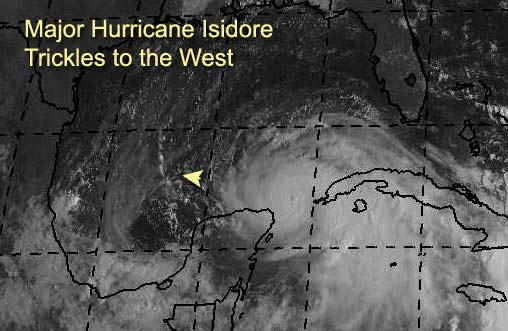
3:30 PM Update
Tropical Depression 13 Will be forming near 10.4N 44.9W (East of the caribbean islands) at 5PM, track expected to strengthen into a storm over the next few days. More later.
Recon reports Isidore's pressure drop to 946 millibars.
3PM Update
Isidore is strengthening, and aircraft recon found evidence of a mesovortex (Tornado-like "mini eyes" within the eyewall of a major storm that tend to cause Andrew scale ground damage). Which suggests we may have a category 4 hurricane in the gulf soon. It has slowed its forward motion. I still think it'll scoot a bit more west, but now I think the chances for a northerly turn are greater now. Still the Entire Gulf, especially LA to Alabama needs to watch. This story is not over by a long shot.
Original Update
Bad puns in topics aside, we now have a Category Three Hurricane moving slowly in the Gulf, near the Yucatan Peninsula, that may be in the Gulf for quite a while.
This is both good and bad, good because upwelling may occur and the environment may change to actually keep Isidore's strength in check or weaken, bad because it's a major hurricane in the Gulf that models are going wild with. So it may not decrease.
For example, this mornings GFDL model run shows the storm hanging out in the Bay of Campeche. This still makes the strike zone anywhere in the Gulf from Mexico to Florida, and is a little unsettling. Why, some of the other models, which are longer range, have it heading north after a while, and potentially restrengthening again. The length of time this system will wander around will continue to give EM folks around the gulf coast a headache, and everyone else will need to watch it. Mexico to Florida... still. Concentrating on the north central Gulf coasts from tX/LA to FlAL lines. However, if it slides more westward Mexico may get it (Watch the trends). Although I don't think it'll landfall in the Yucatan.
Kyle is a subtropical storm and is also not going anywhere fast. And two more waves in the open Atlantic will have to be watched. As they may near the Caribbean later.
Jim Williams and Barometer bob are doing live Audio shows starting at 8PM and lasting usually to 10 or 11PM all during Isidore's run. Use the link below to check them out.
Havana, Cuba Radar
NRL Monterey Marine Meteorology Division Forecast Track of Active Systems (Good Forecast Track Graphic and Satellite Photos)
NASA GHCC Interactive Satellite images at:
North Atlantic Visible (Daytime Only), Infrared, Water Vapor
Some forecast models:
NGM, AVN, MRF, ETA ECMWF
DoD Weather Models (NOGAPS, AVN, MRF)
AVN, , , , , UKMET
Other commentary at Mike Anderson's East Coast Tropical Weather Center, Robert Lightbown/Crown Weather Tropical Update Accuweather's Joe Bastardi, Hurricane City Weather Audio Broadcast Network - Live Audio from Jim Williams and Barometer Bob , Tropical Weather Watchers.Com (JasonM) Gary Gray's Millennium Weather, Barometer Bob's Hurricane Hollow, Snonut, Ed Dunham and Jason M in our Storm Forum Even more on the links page.
- [mike@flhurricane.com]
|
scottsvb
Weather Master
Reged:
Posts: 1184
Loc: fl
|
|
looks like wobbles to the sw continue, rainfall amounts of near 2 feet over the next 72 hours on the northern and Neastern part of the Yucitan. Somehow if this system stays slow and even stalls at times during the next 60-72 hours. There will be a chance for the turn to the N. Matters on how far south the next trough gets. For florida right now it has to stay E of 90W for the next 60 hours. Ill post a complete forcast later, but my forcast from a few days back on a turn to the WSW came true, but will it make it near Tampico its hard to tell. scottsvb 
|
Steve
Senior Storm Chaser

Reged:
Posts: 1063
Loc: Metairie, LA
|
|
1) BD: Here are some links for your mom:
http://wwwghcc.msfc.nasa.gov/GOES/goes8hurrir.html
http://www.ssd.noaa.gov/PS/TROP/DATA/RT/FLOAT/IR4/20.jpg
Steve
--------------------
MF'n Super Bowl Champions
|
HanKFranK
User

Reged:
Posts: 1841
Loc: Graniteville, SC
|
|
izzy's getting pushed only a little, staying between upper lows. big question now is how far west the storm gets before the ridge to the east rebuilds and hooks it up with a shortwave. my thoughts have changed just a little.
three major differences with the official:
1)system will probably move right along the yucatan coast.. i mean something like 20 miles inland to offshore. land intereaction has a history of slowing the forward movement (it took a really long time to cross western cuba yesterday).. think the track is too fast. not thinking the storm will get west of 92w, but yeah probably 90. think the storm will wobble along its path, but smoothed should resemble .
2)intensity.. naturally mine is lower, since i think the storm will be interacting with land more. think it stays in the 2-3 range through 72hr, except maybe it gets to 4 right before approaching the coast tonight.
3)think after 60hr the wsw component is gone, storm should be moving north of west again.
my endgame has changed too.. shifting it westward, focused on the central gulf. se louisiana to the western panhandle now. expect the storm to bend north, but northeast before reaching the coast. expect it to come ashore at category three/four on thursday or friday.
other systems:
1)kyle. should be fully tropical later today, stall and move erratically through 36hr, then next week start sw and eventually west. a couple of the models have it getting under the newfoundland wheel and accelerating west, as lili did in 1990. not quite ready to take it that far, but suffice to say it could be pretty close to bermuda by the middle of next week.
2)92L. this should be a depression tomorrow. it is moving west fairly quickly, and think it will develop slowly as a result. probably enter the caribbean late monday/early tue as tropical storm lili. whether or not it kills itself with forward speed i'm not quite sure. if it doesnt, will be threatening the western caribbean or southeast u.s. a week from now.
3)the bastardi pinwheel. surface low pressure is disorganized and not moving much, but convection has shifted northward yesterday and something may start to gel tomorrow east of the carolinas. this seems less probable than it did thu or fri, but still a chance it could make some late hour organization as it accelerates ahead of a trough off the east coast. as the upper low decays the area southwest of it up to its remnant axis will have to be watched for further activity.
4)east atlantic wave. basically three possibilites. one, it develops and recurves well out to sea early next week. two, it doesnt develop. three, it moves westward and then develops later next week closer to the islands and becomes another nuisance.
so there, two active systems, maybe one or two more before all's said and through with this span. probably a major hurricane landfall between morgan city and fort walton beach as well.
HF 1603z21september
Edited by HanKFranK (Sat Sep 21 2002 04:09 PM)
|
Steve
Senior Storm Chaser
Reged:
Posts: 1063
Loc: Metairie, LA
|
|
You gotta love tropical season. I took care of my two main worries today - plywood for 2 windows in my safe room and provisions.
We've decided to make my bedroom the safe room because it has access to the attic just in case. There was a need for a 40 x 50 and a 40 x 69 cut of plywood. Got a new flashlight for one of my kids and updated the AA battery supply. Home Depot was just starting to get crowded. I only had to wait about 10 minutes for my plywood to be cut.
I Hit Sav-A-Center next. We bought 12 gallons of Kentwood Spring Water to go with the 36 12 oz bottles of Ozarka I already have. We had a bunch of non-perishables already in stock. I also got some coals and starter fluid - you can never have enough of that if there is power or gas line interruption. Then I picked up a 12-pack of Abita Amber and a case of Coors Light. Beer is another thing you can never have too much of  . I know about 12 of 'em will be gone tomorrow with the NFL, but I can always restock later. Btw, water was getting REALLY low at Sav-A-Center. They still had a few hundred gallons, but that will be gone by noon. I'd say the boys at the Abita Springs and Kentwood bottling plants have their work cut out for 'em the next few days. . I know about 12 of 'em will be gone tomorrow with the NFL, but I can always restock later. Btw, water was getting REALLY low at Sav-A-Center. They still had a few hundred gallons, but that will be gone by noon. I'd say the boys at the Abita Springs and Kentwood bottling plants have their work cut out for 'em the next few days.
The main reason I wanted to post this stuff is to let remind everyone between Brownsville and Tampa that now is the time to act. Most of us already have half of our stuff in place (first aid kits, flashlights, etc.). The rest will be disappearing from the shelves little by little until the lines become unbearable. Since you're more aware than the average bear (obvious because you're reading this forum), be smart and go take care of stuff now so you'll only have a few things to deal with mid-week - topping off your gas tank, replenishing ice. Only having to wait in 1 or 2 lines beats the snot out of having to wait in 5!
Steve
--------------------
MF'n Super Bowl Champions
|
Anonymous
Unregistered
|
|
Thanks so much for the links Steve..... they are great.
Regards
BD
|
Justin in Miami
Storm Tracker
Reged:
Posts: 269
Loc: Ft. Lauderdale, Florida
|
|
Steve,
Excellent point..never hurts to have all that stuff in house anyway....btw are you covering all the windows in your home?
|
scottsvb
Weather Master
Reged:
Posts: 1184
Loc: fl
|
|
l might have to change my long term forcast from 4 days back on my near Tampico thing. It might be a dramatic change. I saw something on sat pics yesterday and is becoming more apperent. Lets just say New Orleans to Tampa watch this, but of course all the way down to the BOC.
New data coming in.....very,very strong shortwave trough coming down to reinforce the southern trough early next week to mid week. If this does happen to what is shown. Expect Isadore to move very close to ifnot into the Yucitan, BUT then head back N to then NE into maybe even the SE gulf and NE to Cedar Key by Thurs?? All just speculation.
New ETA is out now that goes out 60 hours, shows what Im seeing, WSW then NE off NE part of Yucitan (never bringing it more then 88W) and back moving NNE near to where it is now about 23N and 86W. That would be scary for florida,, but hey folks its just 1 model and solution. Lets see more models, continued verified runs 12-24,36 hours later and the digging of the trough early next week. In the mean time, lets see if he does make landfall onthe NE tip of the Yucitan. scottsvb hurricaneupatecenter
|
Justin in Miami
Storm Tracker
Reged:
Posts: 269
Loc: Ft. Lauderdale, Florida
|
|
Interesting story from China. Evidently a new law there says that if you wrongly report information about the hurricane to up ratings you will be fined...not sure all the specifics about the story but heard about on the local news down here. Interesting tid bit of fact from another part of the world that deals with storms.
|
Anonymous
Unregistered
|
|
if it hits u/p and stays ther good by izzy
|
BabyCat
Weather Guru
Reged:
Posts: 150
Loc: New Orleans, La.
|
|
Steve, you forgot to mention an axe. You say attic, I think axe.
Neurotic? Maybe....
I've had the bejeesus scared out of me a few times with storms.
Stay safe!
|
Rasvar
Weather Master

Reged:
Posts: 571
Loc: Tallahassee, Fl
|
|
Scott: I was a lot happier when you were sticking with Tampico! The Cedar Key scenario is a mess. I hope that one flits away. I can only envision massive flooding from St Pete north on a situation like that.
--------------------
Jim
|
Kevin
Weather Master

Reged:
Posts: 524
Loc: EC Florida
|
|
I also saw that shortwave digging down on some of the non-tropical models. It concerns me, but I'm not biting on until I see consistency. Ever since Tuesday and Wednesday I have been extremely bullish on a Florida landfall from Pensicola to Cedar Key. If the models are more consistent in the strength of this shortwave and if actual data back the models up, I may just have to say Pensicola to Tampa threat in a couple of days.
Keep watching as the forecasting process with Isidore is being smoothed out.
Kevin 
|
Frank P
Veteran Storm Chaser
Reged:
Posts: 1299
|
|
I live on the beach in Biloxi... I have six - 3 foot X 6 foot windows in the front of my house on the first floor and four - 3 foot by 5 foot windows on the second floor, all facing the beach.... this does not include another 8 windows that do not face the gulf. so when I board up it takes quite a while... I only board up the beach windows, unless its a Cat 4 then I board up everything including all exterior doors but one...
as a rule of thumb I never board up my house if I'm sure the system will hit east of me... say from AL/FL line.... experience has taught me it is not necessary because I am so sheltered from any winds from the north...
and people who put tape on windows are wasting their time and money... I've seen taped windows blow out.... my advise... board em up....
|
Steve
Senior Storm Chaser
Reged:
Posts: 1063
Loc: Metairie, LA
|
|
No. This is my uncle's house so I'm only boarding up my saferoom.
Cat - Yeah, I was supposed to buy an axe or hatchett at Home Depot today but I forgot. I'll pick one up from Ace on Tuesday if there is a more likely threat.
-------------------------------------------------
Comments on the WSW/W movement. Isidore has moved 1.5 degrees west the last 12 hours putting her near 86.1 as of 11am EDT. Something all of us North Gulf Coasters are going to have to watch is how far west and how far north Isidore is at 72 hours. I'm much more worried about a WNW solution rather than a westerly one near term. When the eventual parabolic curve takes place, it's best for my area that Isidore is much further south. That increases the threat to points east of the AL/FL line. If she's up around 26 or 27, look out LA/MS. Also, a WNW track after 24-48 hours is far more disturbing to SE LA, Coastal MS residents. Having said that, I'm very comfortable with 's 92.5 option at 72 hours. They've done a good job so with their Isidore tracks and deserve credit for them so far. The only way Isidore doesn't get to 92.5 west is if the southerly component of the current track is not just temporary. Since the shortest distance between 2 points is a straight line, any deviation away from due west will lessen the liklihood that he actually makes it to 92.5. However, the 12 UTC tropical tracks bring him as far west as:
BAMD - 96.2
BAMM - 96.3
A98E - 93.9
LBAR - 92.0
The SHIP and DSHIP intensity models of 125 knots at 72 hours is pretty disturbing. If I remember my coversion table right, that's a solid 140mph Cat 4 storm.
Steve
--------------------
MF'n Super Bowl Champions
|
scottsvb
Weather Master
Reged:
Posts: 1184
Loc: fl
|
|
Im still not changing my forcast yet,, I just want to make aware things could change. I still have a near tampico thing, but if it makes landfall just north of there who knows.
scottsvb
|
recmod
Weather Guru

Reged:
Posts: 188
Loc: Orlando, FL
|
|
Oh no....I can already hear Shawn clicking on his keyboard all the way across the GOM after scottsvb's comments putting a threat back in the FL forecast
NO wishcasting here! 
Lou
|
Steve
Senior Storm Chaser
Reged:
Posts: 1063
Loc: Metairie, LA
|
|
I agree. If Isidore was to have a North Mexican or south Texas landfall - UKmet's solution I think there are 3 possibilities. 1) Continues to head W into TX/MX (least likely IMHO); 2) comes up north ahead of the next shortwave after the one you mentioned and gives Eastern TX all the rain they can handle (second least likely); 3) re-emerges out in the Gulf and heads off to the FL Panhandle at a pretty quick speed as probably a Cat-1.
Do you see any other logical possibilites in the event of a North Mex/South TX landfall?
Steve
--------------------
MF'n Super Bowl Champions
|
Steve
Senior Storm Chaser
Reged:
Posts: 1063
Loc: Metairie, LA
|
|
http://www.hurricanealley.net/10Ltrpmdl.html
I think the LBAR solution is very disheartening. I'm not buying it, but that's exactly where I wouldn't want to see Isidore in 72 hours. A98E (surprisingly since that model does funny things) seems to make the most sense right now for the next 72 hours.
Steve
--------------------
MF'n Super Bowl Champions
|
Steve
Senior Storm Chaser
Reged:
Posts: 1063
Loc: Metairie, LA
|
|
While looking at the HIstorical Tracks at Weather Underground - those Cat 3's, 4's and 5's that passed within 300 miles of Isidore's center in September - it's evident that Isidore doesn't share a consistent track with any of the other storms. Most of them went into Florida or Texas. Isidore will be carving her own trail for future historical tracks.
Steve
--------------------
MF'n Super Bowl Champions
|


 Threaded


