LI Phil
User

Reged:
Posts: 2637
Loc: Long Island (40.7N 73.6W)
|
|
Tropical Storm Bonnie passed through this morning/afternoon with relatively little problems. That's the good news. Unfortunately, that's about it for the good news for now.
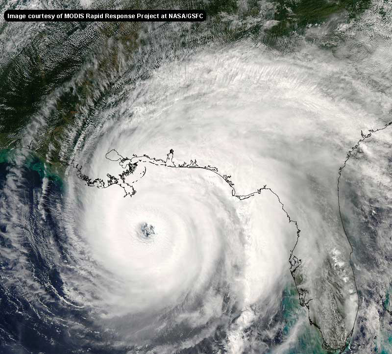
Hurricane remains a 105 mph Hurricane as of the last official update, although it appears his winds would be much stronger than that. Many expect to be upgraded to Category III status by 11:00 EDT, Thursday night (8/12/04).
Tomorrow, not coincidentally, is Friday the 13th. For those triscadecaphobes, this could spell a triple whammy. One, it's Friday the 13th. Two, There are some projected landfalls at astronomical high tide. Three, this part of the nation hasn't seen a storm of this magnitude in 40 or more years.
For those who are in the warning area , if you are told to evacuate, you must do so, or remain at your own peril. While the landfall point is still uncertain, it would appear from all modeling and extropollation that Tampa/St. Pete is the bulls-eye, though any area 100 to 150 miles either way could be the recipient. Anyone with interests from Key West to Pensacola should have some kind of evacuation plan ready by now.
While it is entirely possible this storm could de-intensify or change course, it is also quite possible this system could intensify to Category IV. Therefore, it is most important to heed the warnings of the and your local weather service, which is receiving the same data from . We are facing potentially the largest peacetime evacuation in United States history. They would not call for such unless the danger is real.
If you own a NOAA radio, you should make sure it is on and have battery backup. If your preparations to protect house and home are complete, you should be heading to a shelter as soon as possible. If you haven't prepared your abode for a possible major hurricane impact, you should take whatever quick and decisive action as is necessary, and head for a safer location, if possible.
I want to wish everyone in the warning areas the best of luck and godspeed. I pray for a weak hurricane at landfall, but this has the potential to impart massive damage. Storm surge could approach 15' or even greater, in the areas hit with the eyewall.
Again, stay tuned to the official weather sources (but do check back here, this site will have all the latest, up to date data, warnings & information), and if you are told to leave...please...do so. This COULD (emphasis on could) be one for the record books.
Good luck and god bless.
Currently the National Hurricane Center has what I consider the best bet.
* site note * our automatic tracking map has been disabled temporarily due to a crash issue with the map generation program.
Event RelatedLinks
Hurricane City is having live audio and video broadcasts throughout the day on Bonnie/Charley and Jim's Audio show is from 8PM to 11PM EST
All model "Spaghetti" for Bonnie/Charlie from hurricanealley
Another Multi-Model Track plot for
General Links
Current Aircraft Recon Info
NRL Monterey Marine Meteorology Division Forecast Track of Active Systems (Good Forecast Track Graphic and Satellite Photos)
Check the Storm Forum from time to time for comments on any new developing system.
Follow worldwide SST evolution here:
Global SST Animation
NASA GHCC Interactive Satellite images at:
North Atlantic Visible (Daytime Only), Infrared, Water Vapor
LSU Sat images
Some forecast models:
NGM, AVN, MRF, ETA ECMWF
AVN, , , JMA, , UKMET
DoD Weather Models (NOGAPS, AVN, MRF)
Multi-model plots from WREL
Other commentary at Independentwx.com, Robert Lightbown/Crown Weather Tropical Update Accuweather's Joe Bastardi (now subcriber only unfortunately), Hurricane Alley North Atlantic Page, Cyclomax (Rich B.), Hurricane City , mpittweather , Gary Gray's Millennium Weather, storm2k, Barometer Bob's Hurricane Hollow, Snonut,
Even more on the links page.
Edited by John C (Fri Aug 13 2004 01:30 AM)
|
Anonymous
Unregistered
|
|
Live TV Coverage from Tampa FL on your computer
http://www.wtsp.com/news/live.asp
http://www.hardcoreweather.com
|
joepub1
Storm Tracker
Reged:
Posts: 240
Loc: Jacksonville,Fla
|
|
Thanks for the new thread. Things are getting hairy on the west coast of Florida.
The 0000 utc SHIP has as a 80kt storm as it goes by me in Jacksonville. That's after it goes across the state. Somehow that doesn't compute with me. The numerical models show not much more movement to the west ( no more than 83W) and it makes landfall only, or just because, he runs into land. I hadn't thought about the fact he's not west of tampa yet. He comes in south of Tampa and strong, 97kts. Now all this is according to the numerical models, not me.......
He's going to be quick across Cuba, no more than a couple of hours. He's going across the thinnest possible overland route he could find, he really has taken advantage of every break he could get from mother nature. This will change the way I think of the GOM in August for a long time. 
|
SirCane
Storm Tracker

Reged:
Posts: 249
Loc: Pensacola, FL
|
|
Hmm, wonder what will have in store on Friday the 13th? Change of track? Something unheard of? That's scary. Batten down the hatches folks!
|
John C
Unregistered
|
|
Does anyone see a more southerly track then predicted?
|
Cocoa Beach Guy
Unregistered
|
|
Maybe John C, check out the radar and satellite - looks like it's going due north by now
http://www.srh.noaa.gov/radar/loop/DS.p20-r/si.kbyx.shtml
http://www.ssd.noaa.gov/PS/TROP/DATA/RT/float-wv-loop.html
|
cyclone_head
Weather Hobbyist

Reged:
Posts: 74
Loc: Florida
|
|
Great Intro to the new thread Phil....
|
Bruce
Weather Guru
Reged:
Posts: 139
Loc: Palm Bay, Florida
|
|
John, I agree, Im going with HF on Sanibel Isl. Radar from Key West has shown almost due North for the last 3 hours.
|
ChrisT
Verified CFHC User
Reged:
Posts: 12
Loc: Coral Gables/Sanibel Island
|
|
Although not very good with hurricanes, the latest BAMM model appears to have shifted back to the east again - bringing ashore in the Ft. Myers/Punta Gorda area.
|
alan
Weather Hobbyist

Reged:
Posts: 95
Loc: Apopka, FL
|
|
I've been thinking the same thing lately, that it looks like it's going north much quicker than expected.
|
Anonymous
Unregistered
|
|
Any new recon info ? Or can we not fly around cuba ?
http://www.hardcoreweather.com
|
DroopGB31
Weather Guru
Reged:
Posts: 122
Loc: Pensacola
|
|
So what is your guy's best guess on what time tomorrow will make landfall? Im gonna say between 5 and 9pm tomorrow evening. It really all depends on the track. If stays more NNW then it will have more time out in the gulf. If he starts turning NNE that will cut back alittle bit of the time he has before he makes landfall. So what do you guys think?
|
joepub1
Storm Tracker
Reged:
Posts: 240
Loc: Jacksonville,Fla
|
|
I think it's possible because like I posted a few back, he's not west of Tampa, and I'm not sure he ever will get west of Tampa. So he would have to come in south of there even if he went straight north from this point on and never curved at all. This is really a gentle curve that he's forecast to have.
So how bout this: If he turns north (000) before he gets to the Keys, then he could be the stronger southern storm that doesn't weaken before landfall, BUT NOT SE FLORIDA !!!! I did not say MIAMI !!!! Get him out to 83.5-84W then Tampa (maybe) or north.
|
GuppieGrouper
Weather Master
Reged:
Posts: 596
Loc: Polk County, Florida
|
|
I don't think anyone will know for sure what this cane is going to do until it completely clears cuba and decides how it is going to react to that trough. This is the dicey part coming up. When this is resolved, we will know for sure what direction the thing is going in. After that, it probably won't matter exactly who gets the landfall until it gets to the evacuation orders of other areas of the state.
--------------------
God commands. Laymen guess. Scientists record.
|
cyclone_head
Weather Hobbyist

Reged:
Posts: 74
Loc: Florida
|
|
Thanks Cocoa Beach Guy...
The radar loop definitly points out what John C. was noticing.
It looks like Ft Meyer now...or even south of that...It seems to be in some transition now....according to the last few frames. Is the proximity to land having effect?
|
Rasvar
Weather Master

Reged:
Posts: 571
Loc: Tallahassee, Fl
|
|
I have to give props to the on air Meteorologist on TV 28 in Tampa. Using a simple paper map, he gave one of the best explainations of the effects of various landfalls I have seen in a while.
|
Rasvar
Weather Master

Reged:
Posts: 571
Loc: Tallahassee, Fl
|
|
I would not read a lot into a radar loop. Unless it is a three hour loop. Too many wobbles occur in the short term. Have to take the average motion.
|
ShaggyDude
Weather Guru

Reged:
Posts: 112
Loc: Cocoa Beach, Florida
|
|
No problem, cyclone head.
I guess since it's appropriate, I should join. I've been reading here for a while, getting lots of great info, so just trying to return the favor and help.
Anyways, i've been scouting for model sites trying to find anything that can correspond to current storm information, does anybody know if they've been updated, and where they could be found?
Thanks - CB Guy
|
Rasvar
Weather Master

Reged:
Posts: 571
Loc: Tallahassee, Fl
|
|
I see a little what is being said. Not really sure I will consider it a trend as much as a cuase of land interaction. I think it may resume a nnw motion for a bit once it gets over Cuba.
|
BillD
User
Reged:
Posts: 398
Loc: Miami
|
|
I have seen what I think is a more northerly shift over the last couple of hours on the key west and cienfuego radars, and IR. But I haven't said anything because I think we need to see a longer trend than an hour or two. Give it a couple more hours and lets see what happens. Although I haven't said anything before, I'm with bobbi on the trend more to the east (and I am not wishcasting). Just take a good long look at those water vapor loops. I don't think Miami is in trouble, I just think its going to landfall further south than currently predicted. I think this is what the is worried about.
Bill
|


 Threaded


