jr928
Weather Guru
Reged:
Posts: 101
|
|
great sats and visibles
http://www.geocities.com/tropicwx/
|
Hugh
Senior Storm Chaser
Reged:
Posts: 1060
Loc: Okaloosa County, Florida
|
|
Quote:
can't say that I disagree hugh. I would say my very untrained eye is seeing the stronger storm tightening again and since it grew during eye wall repl it look more northward. but I'm an idiot when it comes to real weather so bear with me
Me too - but as I said I know what I have heard on TV from "weather guessers" if you will - and putting two and three together I get six and a potential turn SOON.
--------------------
Hugh
Eloise (1975) - Elena and several other near misses (1985) - Erin & Opal (1995) - Ivan (2004)
|
Ron Basso
Storm Tracker

Reged:
Posts: 267
Loc: hernando beach, FL
|
|
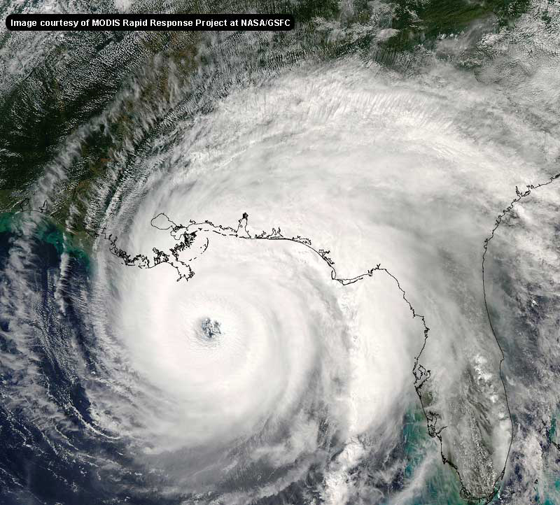
Yeah, check out the explosion of convection on this IR SAT. The has really expanded to the north and east over the last several hours. This looks like one massive storm - may be our 21st century Camille.
http://www.rap.ucar.edu/weather/satellit...amp;duration=10
--------------------
RJB
|
pryord1
Weather Watcher
Reged:
Posts: 49
Loc: Navarre, FL
|
|
I would like to know the same thing. Have you received a response for this posting? If so, would you please share it with me? Thanks!
--------------------
The key to a good life is higher thought. Challenge yourself, push your personal limits and go for the brass ring!
|
Margie
Senior Storm Chaser

Reged:
Posts: 1191
Loc: Twin Cities
|
|
Well on wv sat images it looks like is reorganizing quite rapidly.
Looking at conditions on buoy 42003 as the hurricane moves past, south of it. This buoy is located NW of the storm, at 1.5N and 0.5W relative to the storm's current position (could someone work out how many miles away that is). Wave heights have averaged over 20 ft since early this morning and are currently approaching the 25 ft mark as windspeed has been increasing (up to around 40kts steady now). The waves will probably be even higher shortly, as the storm is directly S and the wind shifts to due E.
It looks like the only other buoy before landfall will be 42001, tomorrow, because 42041 is not in service anymore.
Edit - Oh WLOX has an excellent online hurricane center for resources for MS, and also tracking map that shows buoy locs and the shortcuts to the NOAA page for each.
http://www.wlox.com/
--------------------
Katrina's Surge: http://www.wunderground.com/hurricane/Katrinas_surge_contents.asp
Edited by Margie (Sat Aug 27 2005 08:29 PM)
|
Hugh
Senior Storm Chaser
Reged:
Posts: 1060
Loc: Okaloosa County, Florida
|
|
Quote:
I would like to know the same thing. Have you received a response for this posting? If so, would you please share it with me? Thanks!
No one has mentioned the pressure on that recon yet, and it is still not posted anywhere on that I can find.
--------------------
Hugh
Eloise (1975) - Elena and several other near misses (1985) - Erin & Opal (1995) - Ivan (2004)
|
Reaper
Weather Watcher

Reged:
Posts: 45
Loc: Lake Placid, Fla
|
|
The eye is getting that cool "stadium Look" to it now....
|
Hugh
Senior Storm Chaser
Reged:
Posts: 1060
Loc: Okaloosa County, Florida
|
|
Quote:
Yeah, check out the explosion of convection on this IR SAT. The has really expanded to the north and east over the last several hours. This looks like one massive storm - may be our 21st century Camille.
and it still has all day tomorrow at the very least to intensify even further. I suspect even if it makes landfall at N.O., we may get hurricane force winds in the Panhandle as huge as it is becoming. Not 140+, but 75 is possible in gusts maybe.
Edit to reply to Reaper:
I do not find anything "cool" about the stadium effect in a hurricane, personally!
--------------------
Hugh
Eloise (1975) - Elena and several other near misses (1985) - Erin & Opal (1995) - Ivan (2004)
Edited by Hugh (Sat Aug 27 2005 08:23 PM)
|
Storm Hunter
Veteran Storm Chaser

Reged:
Posts: 1370
Loc: Panama City Beach, Fl.
|
|
Quote:
Quote:
Recon just reported a reading of 119 knot winds ... that's 137 mph...
I don't see the recon report at - what was the pressure?
All i see was this....must of missed something
URNT12 KNHC 271909
VORTEX DATA MESSAGE
A. 27/18:56:30Z
B. 24 deg 28 min N
085 deg 21 min W
C. NA mb NA m
D. 55 kt
E. 47 deg 016 nm
F. 146 deg 098 kt
G. 049 deg 030 nm
H. EXTRAP 950 mb
I. 13 C/ 2438 m
J. 20 C/ 2438 m
K. 16 C/ NA
L. WEAK NW
M. C45
N. 12345/NA
O. 0.02 / 2 nm
P. AF306 WX12A 01 OB 09
MAX FL WIND 98 KT NE QUAD 18:47:40 Z
SLP EXTRAP FROM 8000 FT
INNER EYE REMNANT 25% COVERAGE SW - S 5 NM FROM FIX POINT
i think this means is about over
--------------------
www.Stormhunter7.com ***see my flight into Hurricane Ike ***
Wx Data: KFLPANAM23 / CW8771
2012== 23/10/9/5 sys/strms/hurr/majh
|
Hugh
Senior Storm Chaser
Reged:
Posts: 1060
Loc: Okaloosa County, Florida
|
|
Quote:
Quote:
Quote:
Recon just reported a reading of 119 knot winds ... that's 137 mph...
I don't see the recon report at - what was the pressure?
All i see was this....must of missed something
URNT12 KNHC 271909
VORTEX DATA MESSAGE
A. 27/18:56:30Z
B. 24 deg 28 min N
085 deg 21 min W
C. NA mb NA m
D. 55 kt
E. 47 deg 016 nm
F. 146 deg 098 kt
G. 049 deg 030 nm
H. EXTRAP 950 mb
I. 13 C/ 2438 m
J. 20 C/ 2438 m
K. 16 C/ NA
L. WEAK NW
M. C45
N. 12345/NA
O. 0.02 / 2 nm
P. AF306 WX12A 01 OB 09
MAX FL WIND 98 KT NE QUAD 18:47:40 Z
SLP EXTRAP FROM 8000 FT
INNER EYE REMNANT 25% COVERAGE SW - S 5 NM FROM FIX POINT
i think this means is about over
That does not mention anything about a 119 knot wind, though... which is the report I was asking about.
--------------------
Hugh
Eloise (1975) - Elena and several other near misses (1985) - Erin & Opal (1995) - Ivan (2004)
|
Terra
Storm Tracker
Reged:
Posts: 286
Loc: Kingwood, Texas
|
|
Quote:
H. EXTRAP 950 mb
Guess they didn't sample over the eye... wonder why it's extrapolated... Maybe it's extrapolated from flight level, but generally it doesn't say this.
--------------------
Terra Dassau Cahill
Edited by Terra (Sat Aug 27 2005 08:28 PM)
|
JG
Weather Hobbyist
Reged:
Posts: 55
|
|
http://radar.weather.gov/radar/loop/DS.p38cr/si.kbyx.shtml
Tell me that's just the short term part of the loop and nothing else. I hope that's just a wobble..... 
|
Hugh
Senior Storm Chaser
Reged:
Posts: 1060
Loc: Okaloosa County, Florida
|
|
Quote:
http://radar.weather.gov/radar/loop/DS.p38cr/si.kbyx.shtml
Tell me that's just the short term part of the loop and nothing else. I hope that's just a wobble..... 
That's just the short term part of the loop and nothing else.
Oh, you want the truth? Ok, it's just an artifact of being too far from the radar for a reliable track to be obtained.
--------------------
Hugh
Eloise (1975) - Elena and several other near misses (1985) - Erin & Opal (1995) - Ivan (2004)
|
CaneTrackerInSoFl
Storm Tracker

Reged:
Posts: 395
Loc: Israel
|
|
Thats just the remainder of the old eyewall being, I guess, filtered out. Doesn't look like it has any implications on the overall direction of the storm, though.
--------------------
Andrew 1992, Irene 1999, Katrina 2005, Wilma 2005
|
tpratch
Moderator

Reged:
Posts: 339
Loc: Maryland
|
|
It's been mentioned that due to the distance from the tower, that radar data is at an angle that makes motion unreliable.
Take anything you ascertain from it with a large helping of NaCl 
|
Big Red Machine
Storm Tracker
Reged:
Posts: 223
Loc: Polk City, FL
|
|
Hugh, I am unsure of the exact website where you can find that at, but the reading is in another website's forum.
http://www.storm2k.org/phpbb2/viewtopic.php?t=71478&start=400
Hit control f and then type in 119. It will take you to the correct post.
|
Jeffmidtown
Weather Guru

Reged:
Posts: 132
Loc: Atlanta, Ga
|
|
Watching the streaming coverage of WWL-TV and they are saying that the contra-flow of the interstates at 5pm ET and watching the traffic cams from NoLa, it looks like that the folks there are getting out now. Major traffic delays it looks like......
--------------------
You know it's a bad day.....when you wake up and see Jim Cantore and Geraldo Rivera broadcasting from your backyard....literally!
|
Storm Hunter
Veteran Storm Chaser

Reged:
Posts: 1370
Loc: Panama City Beach, Fl.
|
|
URNT12 KNHC 272030
VORTEX DATA MESSAGE
A. 27/2009Z
B. 24 DEG 33 MIN N
85 DEG 23 MIN W
C. 700 MB 2634 M
D. N/A
E. N/A
F. 035 DEG 85 KT
G. 300 DEG 29 NM
H. 945 MB
I. 11 C/ 3062 M
J. 19 C/ 3066 M
K. 13 C/ NA
L. OPEN W
M. C08-50
N. 12345/7
O. 1/1 NM
P. NOAA3 1312A OB 23
MAX FL WIND 108 KTS NE QUAD 2015Z
ohhh......here we go! How big will she get?
--------------------
www.Stormhunter7.com ***see my flight into Hurricane Ike ***
Wx Data: KFLPANAM23 / CW8771
2012== 23/10/9/5 sys/strms/hurr/majh
|
SirCane
Storm Tracker

Reged:
Posts: 249
Loc: Pensacola, FL
|
|
Hmm I'm seeing a NW motion. Is that right? Mann
--------------------
Direct Hits:
Hurricane Erin (1995) 100 mph
Hurricane Opal (1995) 115 mph
Hurricane Ivan (2004) 130 mph
Hurricane Dennis (2005) 120 mph
http://www.hardcoreweather.com
|
Hugh
Senior Storm Chaser
Reged:
Posts: 1060
Loc: Okaloosa County, Florida
|
|
Quote:
Hugh, I am unsure of the exact website where you can find that at, but the reading is in another website's forum.
http://www.storm2k.org/phpbb2/viewtopic.php?t=71478&start=400
Hit control f and then type in 119. It will take you to the correct post.
Registration required 
ETA: Advisory is out. Hurricane Watch extended to the AL/FL border. Pressure down to 945 but winds remain 115. Have not read the Fcst/Discussion yet if it is even out.
--------------------
Hugh
Eloise (1975) - Elena and several other near misses (1985) - Erin & Opal (1995) - Ivan (2004)
Edited by Hugh (Sat Aug 27 2005 08:40 PM)
|


 Threaded


