meto
Weather Guru
Reged:
Posts: 140
|
|
yes im afraid we will have two monsters on our hands. in a few days, the waver near 11.0 and the one just about to exit. and they both will be south of c.v.
|
javlin
Weather Master
Reged:
Posts: 410
Loc: Biloxi,MS
|
|
Look at the GHCC site Frank looking 24.5'N and 84.7'W maybe that dreaded "w" world but I did the 10:45 shot and the 11:15 both just alittle further N.
http://wwwghcc.msfc.nasa.gov/GOES/
I know what you mean tracks I would suspect should deviate little E and W from here on out.
Edited by javlin (Sat Aug 27 2005 12:14 PM)
|
Sneakbridge
Verified CFHC User
Reged:
Posts: 20
Loc: Highlands County, Florida
|
|
That looks quite awful for N.O. then. Hopefully it will weaken some. I was very surprised it didn't lose more over the southern tip of Florida. That travel over land didn't seem to bother at all.
|
javlin
Weather Master
Reged:
Posts: 410
Loc: Biloxi,MS
|
|
Some wind shear forcast maps out to 72hrs not the best conditions but also not all that bad.When she builds a little more she might create some of her own enviroment.
http://www.wunderground.com/data/640x480/atlm_shear.gif
|
JG
Weather Hobbyist
Reged:
Posts: 55
|
|
Quote:
That looks quite awful for N.O. then. Hopefully it will weaken some. I was very surprised it didn't lose more over the southern tip of Florida. That travel over land didn't seem to bother at all.
Travel over the Everglades is not like moving over Central Florida. It does not degrade hurricanes very much.
|
SirCane
Storm Tracker

Reged:
Posts: 249
Loc: Pensacola, FL
|
|
From experience with and , both storms ended up further East than what was projected. Can't go by the models. Everyone up here should be prepared. was projected to hit the MS/AL line and ended up hitting the AL/FL line. was expected to hit Mobile (the West side of AL) and he hit one country to the East of Pensacola.
--------------------
Direct Hits:
Hurricane Erin (1995) 100 mph
Hurricane Opal (1995) 115 mph
Hurricane Ivan (2004) 130 mph
Hurricane Dennis (2005) 120 mph
http://www.hardcoreweather.com
|
susieq
Weather Watcher
Reged:
Posts: 49
Loc: Panhandle
|
|
The models are shifting a bit eastward again...
http://www.wunderground.com/tropical/tracking/at200512_model.html
--------------------
Gulf Breeze girl still not over Ivan
|
Terra
Storm Tracker
Reged:
Posts: 286
Loc: Kingwood, Texas
|
|
FYI.... Cantore is in Biloxi.... Stephanie Abrams in Gulf Shores....
--------------------
Terra Dassau Cahill
|
Steve
Senior Storm Chaser

Reged:
Posts: 1063
Loc: Metairie, LA
|
|
>>From exprience with and , both storms ended up further East than what was projected. Can't go by the models. Everyone up here should be prepared.
I agree with that. Even if the 5am landfall track held, you guys all the way to Ft. Walton & Destin would be in on at least close to tropical storm winds. I thnk she's going in east of here but not as far east as I originally thought. If I'm anywhere between Cocodrie and Destin right now, I'm weighing my options and figuring out what I'm going to do. I gotta go to the store this morning then hook up with my dad to find out what his final decision is then clean up the yard of debris. I'm sure most of you on the northern Gulf can relate.
Steve
--------------------
MF'n Super Bowl Champions
|
pcola
Storm Tracker

Reged:
Posts: 344
Loc: pensacola/gulf breeze
|
|
Wow..what a horrible day to be boarding up..95 degrees, I can't wait...this track reminds me so much of , and I really hate it that we are just about to lose long range radar....unlike thou, there has been no recent upwelling of water in the Gulf and the temps all the way to the coast are very warm..and the slow speed is going to create a huge storm surge for somebody, possibly all across the central and NE gulf coast
--------------------
Erin 95 , Opal 95, Ivan 04, Dennis 05, and that's enough!!!!
|
HanKFranK
User

Reged:
Posts: 1841
Loc: Graniteville, SC
|
|
three observations:
that has got to be one of the weirdest wind/pressure relationships i've seen. the storm has been steadily intensifying.. the pressure has fallen to a level more commonly associated with 145mph winds. it is barely category 3 by recon data. there is usually some lag in wind/pressure.. but not like that.
radar obs out of key west are showing a strange inner core structure. the station is far away, but the echoes indicate concentric eyewall type-structure.. with a tiny inner eyewall, a huge gap in the rain shield, then an outer eyewall.
pair these structural oddities and it has me thinking that the storm has entrained a ton of subsidence. there is more feeding from the north.. but this first patch that it started on yesterday is mostly sucked down and probably being worked out. in spite of that the pressure continues to fall. will probably go through an eyewall replacement cycle and adjust to a more conventional wind/pressure relationship in the coming hours.
i'll respond to something ralph said earlier about weakening... that hurricanes past their peak tend to weaken as they near the shore. when you look at the climatology of recurving hurricanes in the gulf, their weakening phase usually begins as they pass the ridge axis. the ridge axis right now is right along the coast.. and is forecast for the coming days to remain pretty much at the coast or just south of it. of the comparisons given.. Opal was an october hurricane that was caught by the trough that had been baroclinically enhancing it and sheared badly, and passed the ridge axis a couple of days before landfall and had a good while to spin down. on the forecast track will be passing the ridge axis as it makes landfall, so by that token it would be very close to maximum intensity.
as of right now the subsidence entrainment should continue for the next day or so, peaking again late today. after that (sunday into monday) the environment should be very close to ideal for to intensify. i wouldn't be surprised if approaches or reaches category 5 at some point on sunday.
going to hang tight at the ms/al border. that's what i should have been doing all along. going to stick w/ a strong 3 because it's a compromise between original ideas and what i'd forecast now.
HF 1242z27august
Edited by Ed Dunham (Sat Aug 27 2005 02:28 PM)
|
Hugh
Senior Storm Chaser
Reged:
Posts: 1060
Loc: Okaloosa County, Florida
|
|
Quote:
Wow..what a horrible day to be boarding up..95 degrees, I can't wait...this track reminds me so much of , and I really hate it that we are just about to lose long range radar....unlike thou, there has been no recent upwelling of water in the Gulf and the temps all the way to the coast are very warm..and the slow speed is going to create a huge storm surge for somebody, possibly all across the central and NE gulf coast
I think you can wait until tomorrow to board up in Pensacola - maybe, anyway - from the standpoint of having time to just board up (if you're not going anywhere but just putting boards up). I *really* hope that does not hit Pensacola. Nothing against New Orleans, but Pensacola still has not fully recovered from and, well, Pensacola landfall would put me just outside of the really nasty stuff (140+ MPH winds projected).
--------------------
Hugh
Eloise (1975) - Elena and several other near misses (1985) - Erin & Opal (1995) - Ivan (2004)
|
SirCane
Storm Tracker

Reged:
Posts: 249
Loc: Pensacola, FL
|
|
Thanks susie. Goes to show these models still don't really have a good handle still. It's going to depend on when the North turn takes place and I expect a NNE turn could happen before landfall.
--------------------
Direct Hits:
Hurricane Erin (1995) 100 mph
Hurricane Opal (1995) 115 mph
Hurricane Ivan (2004) 130 mph
Hurricane Dennis (2005) 120 mph
http://www.hardcoreweather.com
|
Hugh
Senior Storm Chaser
Reged:
Posts: 1060
Loc: Okaloosa County, Florida
|
|
Quote:
caught by the trough that had been baroclinically enhancing it and sheared badly, and passed the ridge axis a couple of days before landfall and had a good while to spin down. on the forecast track will be passing the ridge axis as it makes landfall, so by that token it would be very close to maximum intensity.
as of right now the subsidence entrainment should continue for the next day or so, peaking again late today. after that (sunday into monday) the environment should be very close to ideal for to intensify. i wouldn't be surprised if approaches or reaches category 5 at some point on sunday.
going to hang tight at the ms/al border. that's what i should have been doing all along. going to stick w/ a strong 3 because it's a compromise between original ideas and what i'd forecast now.
HF 1242z27august
Good luck. I'm enough inland that I would not leave even if it were a Cat 5 headed straight for me, but I wouldn't advise most people in the path to do that. I'll go along with your "now" forecast based upon what I'm seeing as far as intensity, despite the fact that Opal/Ivan/Dennis weakened as it came onshore. Near or slghtly above Cat 5 threshhold seems realistic right now with the deepening trend.
my now would be a low end 4. i'm playing a little weakening into the odds, because hurricanes almost never hit at full power. the strong 3 is a compromise. since you're in okaloosa i wouldn't worry too terribly much. unless you're in a mobile home and can animatedly describe 'tar-naders' and ufos to the local news in the worst of southern pidgin, you should be OK. -HF
Edited by HanKFranK (Sat Aug 27 2005 12:59 PM)
|
TDW
Weather Watcher
Reged:
Posts: 37
Loc: Mobile, AL
|
|
Hugh, is there really anywhere in Okaloosa County that is far enough inland if it took a direct hit?
it goes to the alabama border. yeah, in a strong structure you could weather that. -HF
Edited by HanKFranK (Sat Aug 27 2005 01:00 PM)
|
Hugh
Senior Storm Chaser
Reged:
Posts: 1060
Loc: Okaloosa County, Florida
|
|
Quote:
Hugh, is there really anywhere in Okaloosa County that is far enough inland if it took a direct hit?
Well, when I say "far enough inland", I'm assuming that it will weaken substantially. I'm in Valparaiso, and on top of a fairly big hill so I'm away from the bayou (which will flood most of the area). When I say far enough inland, I'm referring to flood threats - which is mostly reduced by living on this hill.
Tornados would be a big problem, and we'd probably get 100+ knot (115 MPH) sustained winds if a Cat 5 made landfall at FWB, but it would do lots more damage to FWB/Destin than here.
Edited by Ed Dunham (Sat Aug 27 2005 02:32 PM)
|
SirCane
Storm Tracker

Reged:
Posts: 249
Loc: Pensacola, FL
|
|
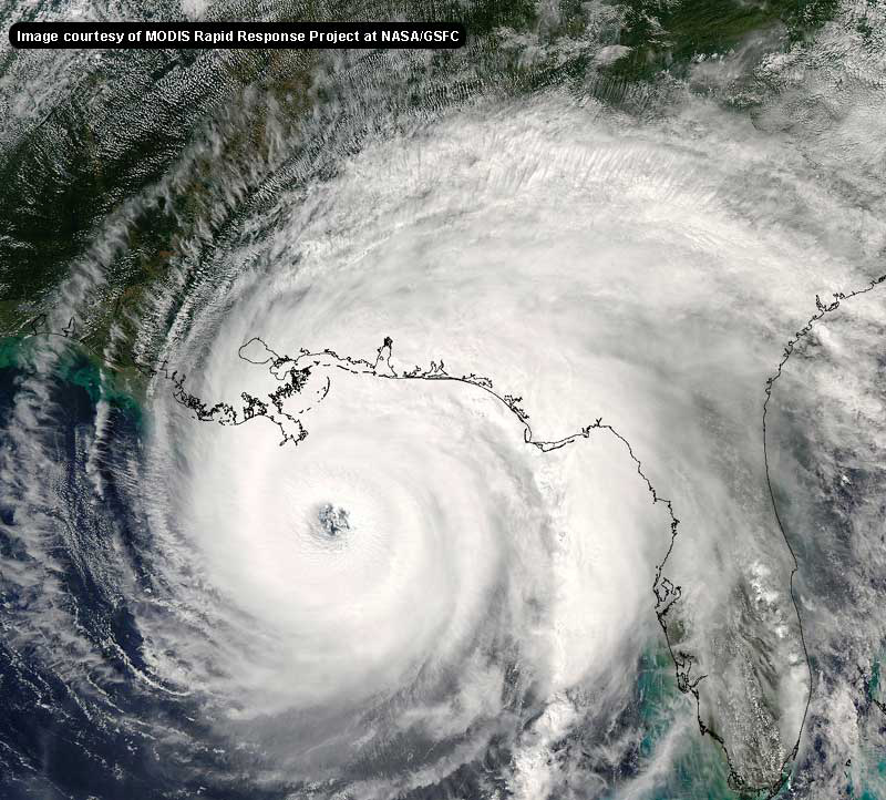
Hmm, these 2 storms look a lot alike. Don't they?
http://i.flhurricane.com/images/2005/katrina8.jpg
http://www.geocities.com/hurricanene/camille.jpg
--------------------
Direct Hits:
Hurricane Erin (1995) 100 mph
Hurricane Opal (1995) 115 mph
Hurricane Ivan (2004) 130 mph
Hurricane Dennis (2005) 120 mph
http://www.hardcoreweather.com
|
Katie
Weather Guru

Reged:
Posts: 167
Loc: Winter Haven, FL
|
|
(removed material that should have been sent in a PM)
NO hit....I wouldn't want to be up there. This isn't looking very good for NO at all. I have noticed that the "cone" has narrowed a lot in the last 24 hours.
Why won't she just start moving? It seems like she has just been in the same place for while now. Enough is enough.
For those of you in the NO area...good luck. Know that a Southern gal in Central Florida (along with Colleen's kids) will be praying for you!
Edited by Ed Dunham (Sat Aug 27 2005 02:36 PM)
|
Hugh
Senior Storm Chaser
Reged:
Posts: 1060
Loc: Okaloosa County, Florida
|
|
Quote:
Quote:
my now would be a low end 4. i'm playing a little weakening into the odds, because hurricanes almost never hit at full power. the strong 3 is a compromise. since you're in okaloosa i wouldn't worry too terribly much. unless you're in a mobile home and can animatedly describe 'tar-naders' and ufos to the local news in the worst of southern pidgin, you should be OK. -HF
Exactly. Although I do know people who are in a mobile home. They can't animatedly describe "tar-naders" though, and I've never discussed UFOs with them!
Cantore just mentioned Elena. I remember Elena. Elena was not pleasant. is no Elena (she's much worse!  ). ).
ETA:
I keep going back to the water vapor loop. Now it's looking like moisture is beginning to form and loop back into from the north. In other words, a hurricane that was lopsided with most of its nasty stuff on the south yesterday looks like it may be getting its act together - getting better organized to use the technical term 
Now, something just does not feel right about saying that a cat 3 hurricane is getting better organized. Is the buildup of "wet" air to the north a sign that the north turn may be beginning soon, or am I paranoid?
ETA2: I just noticed that it looks like it's just growing and growing and growing - it's actually expanded more to the SOUTH than it has to the NORTH. Egads, this is getting HUGE!!!!
--------------------
Hugh
Eloise (1975) - Elena and several other near misses (1985) - Erin & Opal (1995) - Ivan (2004)
Edited by Hugh (Sat Aug 27 2005 01:13 PM)
|
Random Chaos
Weather Analyst

Reged:
Posts: 1024
Loc: Maryland
|
|
I just looked at the 60-hour cumulative rainfall model for 102 hours out (about a day and a half after expected landfall). Even if you aren't anywhere near this thing, expect major flooding:
http://www.nco.ncep.noaa.gov/pmb/nwprod/analysis/namer/gfs/18/images/gfs_p60_102l.gif
|


 Threaded


 ).
).

