MikeC
Admin
Reged:
Posts: 4544
Loc: Orlando, FL
|
|
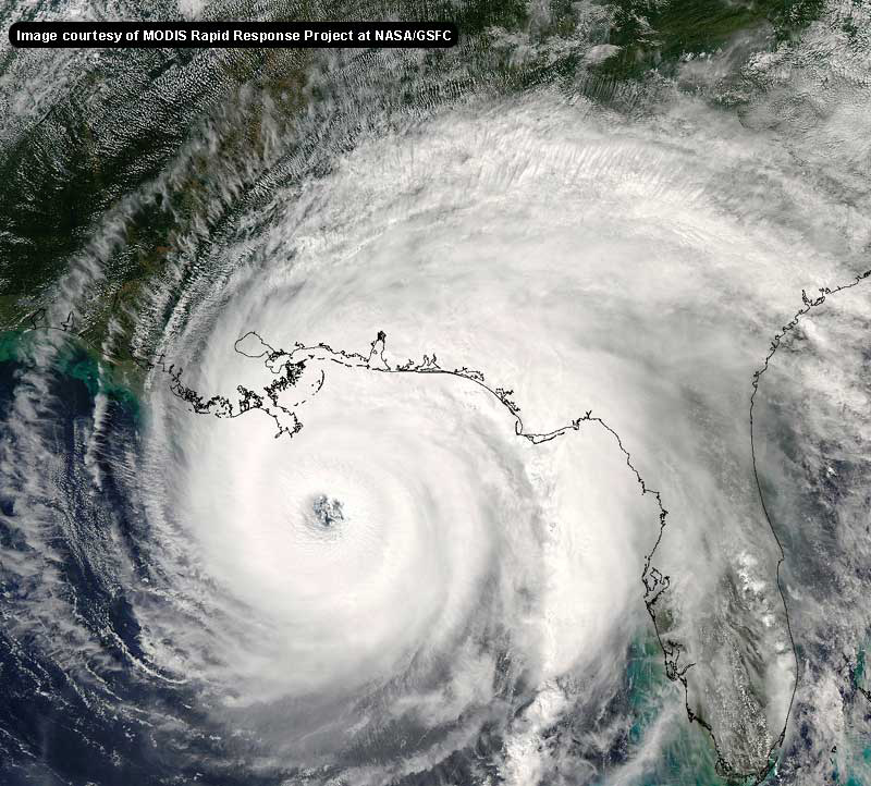
11PM Update
The pressure now sits at 897mb, with maximum sustained winds of 150kt/170-175mph. Slight additional strengthening is forecast within the next 12hr before slow weakening to landfall as a intense category 4/5 storm along the central Texas coastline just west of Galveston. Clark Evans has more in his latest blog entry below, including information of potential impacts along the coastline from New Orleans to Corpus Christi and inland to northern Texas.
8PM Update
The pressure has fallen to 898mb, the third lowest in Atlantic basin recorded history. Additional intensification is likely for the next 12hr before a potential eyewall cycle, though has all of the signs of an annular hurricane.

The strongest storm recorded in the Atlantic was 1988's hurricane Gilbert with 888 mb, and the labor day storm of 1935 with 892 mb.
6PM EDT Update
Hurricane is now the fifth most intense hurricane ever recorded in the Atlantic Basin with a new pressure recorded by the crews of the hurricane hunter aircraft of 904 mb.

Hurricane watches are now up from Port Mansfield Texas to Cameron Lousiana. East of Cameron to Grande Isle and from south of Port Mansfield, TX to San Fernando, MX a tropical storm watch is up.
5PM EDT Update
Rita is now a Category 5 hurricane with surface winds of 165mph and a sea level pressure of 914mb (though even lower were actually measured by dropsondes; the 914mb value is an extrapolated value). This makes it one of the most intense hurricanes on record in the Atlantic basin, just shy of where was 3 weeks ago. Microwave imagery suggest that an eyewall cycle might be 12-18hr away, leaving it plenty of time to unfortunately strengthen further. More soon.

Image courtesy SkeetobiteWeather.com
Comments/Feedback on the maps look here.
Event-Related Links
Emergency Management:
Texas Division of Emergency Management
Links to Texas County Emergency Management
Radars
Florida Keys Long Range Radar Loop
Houston/Galveston, TX Long Range Radar
Corpus Christi, TX Long Range Radar
Brownsville, TX Long Range Radar
Lake Charles, LA Long Range Radar
New Orelans, LA Long Range Radar
Spaghetti Style model plots from Colorado State University
Forecast Discussions for (Show All Locations):
Corpus Christi, TX, Houston/Galveston, Lake Charles, LA
New Orleans, LA
Brownsville, TX
StormCarib hurricane reports from observers in the Islands
Caribbean Island Weather Reports
Color Sat of Gulf
RAMSDIS high speed visible Floater of Storms
Video/Audio
Local Media/Television
KHOU the CBS affiliate in houston, is former Hurricane Center director Neil Frank's station, and likely will begin streaming once warnings are up in the area
Channel 2 NBC affiliate in Houston
ABC 13 in Houston
Radio
KTRH Rado News/Talk station in Houston with streaming
Other Houston area radio
Newspapers
Houston Chronicle
Web based Video and Audio
Many websites require realplayer for video and audio, you can get real player here or an alternative real media player here (Ie WinXp64)
Jim Williams, from Hurricane City and West Palm Beach, is doing his live audio show as approaches on hurricanecity. Listen here
Marc Sudduth over at hurricanetrack.com is in Galveston, Texas. see some of his live streaming video and audio here
Hurricanenow - Former CNN hurricane Reporter Jeff Flock reports n the storm with video updates and live streaming
Weathervine.com storm chasers/video/audio
radioNHCWX not affiliated with the real
Reply and let us know of other links.
Rita

Animated model plots of
Google Map plot of
Floater satellite loops (With forecast track overlay):
Rita Floater Visible Satellite Loop
Rita Floater Infrared Satellite Loop
Rita Floater Shortwave Infrared Satellite Loop
Rita Loop
Rita Water Vapor Loop
Philippe

Animated model plots of Philippe
Edited by Clark (Thu Sep 22 2005 02:43 AM)
|
Thunderbird12
Meteorologist
Reged:
Posts: 644
Loc: Oklahoma
|
|
Looks like they decided to go with the extrapolated 914 mb pressure reading from the last vortex message in the advisory, rather than the lower pressure indicated by the dropsonde.
|
Terra
Storm Tracker
Reged:
Posts: 286
Loc: Kingwood, Texas
|
|
Reposting from the last thread so my post actually gets read....
I'm only saying this because I learned it with and not everyone may remember it.... the motion that the gives is a 6-hour average. So, in the past 6 hours, the storm moved 0.1N, 0.9W, which is essentially due west. This type of binning of data averages out small wobbles and focuses more on true, long-term motion.
--------------------
Terra Dassau Cahill
|
ralphfl
Weather Master
Reged:
Posts: 435
|
|
Repost here also for the NW movement guys.
and yet another category five hurricane this season. Data from both
NOAA and Air Force hurricane hunters indicate a significant
pressure drop today and winds have increased to 145 knots. This is
based on a 700 mb wind of 161 knots recently measured by an Air
Force plane and a recalibrated SFMR surface wind of 146 knots.
Satellite intensity estimates were unanimously 140 knots from all
agencies. Because will be crossing an area of high heat
content during the next 12 to 24 hours...it is expected that the
hurricane will maintain its strength. Thereafter...the ocean heat
content is not as high and the intensity changes will be controlled
mainly by eyewall replacement cycles and decreasing heat content.
Some weakening is anticipated but is forecast to make landfall
as a major hurricane...at least category three.
There has been no change in the steering pattern and is moving
westward or 275 degrees at 11 knots. The high pressure system that
has been forcing westward is forecast to weaken and shift
eastward. This will allow the hurricane to turn gradually toward
the west-northwest and northwest during the next day or two. The
core of is basically moving toward the Texas coast and this is
consistent with the track model consensus.
Try and follow a 6 hr track rather then 2 hrs and you get what it has done all day and that is move a whole .01 which is due west since early today 12 hrs ago.
Note from the There has been no change in the steering pattern and is moving
westward or 275 degrees at 11 knots
where did those guys go now anyway? they been posting non stop the last 3 hrs where did they go?
Edited by ralphfl (Wed Sep 21 2005 09:10 PM)
|
Terra
Storm Tracker
Reged:
Posts: 286
Loc: Kingwood, Texas
|
|
The forecast track did shift the tiniest bit to the north in Texas... at 10am, it was right north of the little indentation... (sorry, I don't know my Texas geography well) and now it is even a little more north.
http://www.nhc.noaa.gov/refresh/graphics_at3+shtml/204204.shtml?3day
--------------------
Terra Dassau Cahill
|
TDW
Weather Watcher
Reged:
Posts: 37
Loc: Mobile, AL
|
|
How much does the forward speed of the storm affect the storm surge? Does a fster moving storm have less of a storm surge?
--------------------
"It's time to see the world
It's time to kiss a girl
It's time to cross the wild meridian"
|
ralphfl
Weather Master
Reged:
Posts: 435
|
|
looks like the same track to me if you run them both at the same time they are no different but that is from my eyes and the tracks they posted.
|
tenavilla
Weather Hobbyist
Reged:
Posts: 95
Loc: Tampa Area
|
|
Repost:
While it's true that 6 hour averages give overall, long-term motion, the bad thing is that if a turn begins shortly before the new advisory comes out, the average motion can be deceiving. For instance, the motion for the first 5 hours may be due west, but if in the last hour a turn begins, it won't necessarily be reflected accurately in the average. taught us that lesson down here. I seem to remember that when he made landfall, the motion for the last official advisory was obviously wrong.
Added: While the motion says west, they did adjust their track a little bit north which may be in response to the northward jog.
|
KATFIVE
Weather Watcher

Reged:
Posts: 25
|
|
For you expert trivia hunters: has there every been a 20 C temperature differential measured in any tropical cyclone?
|
JYarsh
Verified CFHC User
Reged:
Posts: 11
Loc: Virginia Beach, VA
|
|
where did I go Ralph? I went to eat dinner, where did you go, make witty statements about past observations?
Also, the DID adjust their track to the north a little...maybe you should do some more research...
|
Allison
Weather Guru

Reged:
Posts: 134
Loc: Laredo, Texas
|
|
Quote:
it was right north of the little indentation... (sorry, I don't know my Texas geography well
Matagorda Bay... 
--------------------
Allison
|
SirCane
Storm Tracker

Reged:
Posts: 249
Loc: Pensacola, FL
|
|
What's this NW motion I'm seeing?
--------------------
Direct Hits:
Hurricane Erin (1995) 100 mph
Hurricane Opal (1995) 115 mph
Hurricane Ivan (2004) 130 mph
Hurricane Dennis (2005) 120 mph
http://www.hardcoreweather.com
|
D3m3NT3DVoRT3X
Weather Watcher

Reged:
Posts: 48
Loc: The Burg < FL
|
|
Quote:
where did those guys go now anyway? they been posting non stop the last 3 hrs where did they go?
hey ralph it is great that u are stayin firm on your motion but no need to burn others for what they think is or is not happening . i just viewed the goes 1 water vapor and if u turn on the point it is a tad north .. maybe that is what they are goin on .. but no need to be condescending towards others 
|
bobbutts
Weather Hobbyist

Reged:
Posts: 71
Loc: New Hampshire
|
|
Quote:
Reposting from the last thread so my post actually gets read....
I'm only saying this because I learned it with and not everyone may remember it.... the motion that the gives is a 6-hour average. So, in the past 6 hours, the storm moved 0.1N, 0.9W, which is essentially due west. This type of binning of data averages out small wobbles and focuses more on true, long-term motion.
Right.. and what it also does is makes it take several hours for an actual turn to be reflected in the reported heading. I'm not saying that this isn't a wobble.. Just that it's not all that crazy to think that it may be an actual turn. Maybe it's because I saw coming directly at me while the was still saying it was headed for Tampa. I wouldn't start celebrating if I were in Texas, but I would be a little more concerned if I were on the east side of the cone right about now.
|
Random Chaos
Weather Analyst

Reged:
Posts: 1024
Loc: Maryland
|
|
Um...
The topic is "Category 5 Hurricane Moving Westward in the Gulf"
Isn't this "Rita" not ? Someone have on the mind? 
Thanks -- guess it got mixed up in between the two storms! It's fixed now. --Clark
Edited by Clark (Wed Sep 21 2005 09:35 PM)
|
ralphfl
Weather Master
Reged:
Posts: 435
|
|
Quote:
where did I go Ralph? I went to eat dinner, where did you go, make witty statements about past observations?
Also, the DID adjust their track to the north a little...maybe you should do some more research...
run them both at the same time there last track and this one its basicly the same....And the guys i was talking about were the guys who said quote "its going to N.O. or maybe east of there and the other poster who also talked the same.It is suppose to move some north but for them to say what they did was wrong.I am not referring to the fact that it made a jog or not north as anyone can see it made a jog but these guys were talking about trends and about even going east of the big easy and those are who im referring to and they know who they are!
Ralph, no one said it was going east of New Orleans! They said that the motion may have changed a little more to the north and that it made them uneasy, but no one said it was going to hit east of New Orleans. Please, as before, if you have a concern with a post, let us know or send the poster a message privately. --Clark
Edited by Clark (Wed Sep 21 2005 09:37 PM)
|
SirCane
Storm Tracker

Reged:
Posts: 249
Loc: Pensacola, FL
|
|
There is definately a NW motion at this moment, whether it continues I don't know but it can't bode well for New Orleans. I can see it with my own eyes. Just have to see if it's a trend. It's NOT moving due west as of now.
--------------------
Direct Hits:
Hurricane Erin (1995) 100 mph
Hurricane Opal (1995) 115 mph
Hurricane Ivan (2004) 130 mph
Hurricane Dennis (2005) 120 mph
http://www.hardcoreweather.com
|
gogogabby007
Registered User
Reged:
Posts: 5
Loc: Gulf Breeze, FL
|
|
Sir Cane,
Should we see any of the extreme outer bands in the Panhandle area as it crosses through the GOM?
|
DougBaker
Verified CFHC User
Reged:
Posts: 18
|
|
So went from a Tropical Storm to a cat 5 hurricane in about 36 hours?
Has a hurricane ever strengthened this fast?
It is nearly unbelievable
|
SirCane
Storm Tracker

Reged:
Posts: 249
Loc: Pensacola, FL
|
|
I don't know right now. All depends. As of right now I'd say no.
--------------------
Direct Hits:
Hurricane Erin (1995) 100 mph
Hurricane Opal (1995) 115 mph
Hurricane Ivan (2004) 130 mph
Hurricane Dennis (2005) 120 mph
http://www.hardcoreweather.com
|


 Threaded


