MikeC
Admin
Reged:
Posts: 4544
Loc: Orlando, FL
|
|
8 AM EDT Update 25 June 2010
The wave in the western Caribbean (93L) has a decent shot (70%) of developing before hitting the Yucatan, but is still a bit disorganized, but becoming more and more organized, this morning The best chance of development now is tonight or tomorrow, if it does. There is some shear in the area where it is at they may keep it from developing before it reaches the Yucatan, once back in the gulf is a different matter.

Once past the Yucatan it may enter the western Gulf and have another shot at development, and at this point it gets a bit spread out, most likely would be near the Texas/Mexico border, but there is enough model spread to make it worth watching across the rest of the Gulf too.
Hurricane Darby in the East Pacific will likely influence and be influenced by 93L as it gets into the Gulf. Intensity wise, since it's so close to the coast and will be arriving in the Yucatan, along with some shear, and the June factor, it is still very difficult to say.
Aircraft recon will arrive in the area around 2PM to check it out, and it looks as if it is a go today. If it continues to organize like it has been this morning, it may be called as a depression this afternoon.
There is another area east of the Leeward Islands that has a low chance of development (10%) over the next few days, it is not being tracked as an invest area as of this morning.
8 PM EDT Update 24 June 2010
The wave now entering the west Caribbean (93L) has reached far enough west to kick up the chances to 60%, if it were to develop tomorrow through Saturday seems the most likely time, especially if it develops convection overnight. There is shear north of the system that may keep in in check and not develop.
It is expected to near Honduras/Nicaragua, but stay to the north and head into the Yucatan, it likely will have a chance to develop then. Once back in the gulf it may have a chance to strengthen, but it seems shear/dry air may enter into the equation the further north it gets. Those in the Yucatan and Gulf states need to monitor the wave.
Overall though, the most likely scenario still remains that it will stay mostly weak and move toward the Yucatan peninsula of Mexico.
7 AM EDT Update 24 June 2010
The wave in the Caribbean, with an apparent low level circulation southwest of Jamaica, is still holding on, but is taking the slow road toward development. The window for development is tonight through Saturday. The most likely scenario, still, is for it to enter the Yucatan with rain, and it may not develop before it gets there (or very late).

Models are very divergent on where it may eventually go, but the weaker condition of the storm suggests more westerly into the Yucatan. In short, in common with most undeveloped systems, they are still mostly unhelpful.
In short not much has changed with this all week, and it is still very worth watching in the Gulf and Yucatan for changes.
Currently Recon is scheduled to go out there this afternoon, it may be canceled if it doesn't look more organized close to then. (Update: It was canceled this morning)
7 AM EDT Update 22 June 2010
This morning the tropical wave in the central Caribbean (93L) is now south of Hispaniola and moving slowly toward the west, chances for development over the next two days are very low, but improve either Late tomorrow or Friday. Then it may have a better chance for development.
Most of the convection is a bit further north than before, which may actually slow development. IF the system stays further north or east conditions aren't as favorable for development, so this system ever developing is not a guaranteed thing.

This morning the most likely scenario still remains that it will stay mostly weak and move toward the Yucatan peninsula of Mexico, and may enter the southern Gulf after that.
There is enough possible deviation from that to keep it under watch. Intensity models are still a bit useless while there is no formed system, and exact track is a bit up in the air. Those in the the Gulf from the Panhandle and west of Florida and the Yucatan are the ones that should be watching it the closest, and recon is scheduled to go out to this system tomorrow afternoon. Hopefully this will enhance data enough to adjust the models and forecasts to get a clearer picture of what may happen.
7 AM EDT Update 21 June 2010
The wave in the central Caribbean sea is very slowly organizing, and is in an area not known for development at present. According to the National Hurricane Center It currently has a 40% chance for development over the next two days. It has formed somewhat of a broad circulation, but there is no evidence of a low level circulation currently. This likely will keep it a wave for a while, maybe until Thursday evening or Friday. However, aircraft recon is still scheduled to check the system out tomorrow.

There is enough divergence in the models to suggest that it should be watched over the next several days. The most likely track remains into the Yucatan with mostly rain. However, this all depends on a ridge possibly developing along the central and northern Gulf, which would likely keep the system further west.
Since there is no discernible low level circulation, intensity and track models aren't as useful at the moment other than trends over time.
This will have to be monitored all week to see what happens this weekend into next week.
The most likely scenario is still that 93L impacts Yucatan Mexico with rain.
9:30PM EDT Update 21 June 2010
The first signs of a low level circulation are beginning to appear, upping chances for development to about 50%. The circulation is roughly around 14.0N 72.0W. Assuming it maintains itself, it may be upgraded to a depression tomorrow, or more likely after recon gets out there on Wednesday.
Models are still a bit too soon to believe, the latest run appears too far to the north.
6PM EDT Update 21 June 2010
The wave in the Eastern Caribbean Sea (93L) is a rather large system, but currently lacks a low level circulation. Conditions around it support a low chance for tropical development, but if it can hold together the largest chances will be when it reaches the western Caribbean sea later in the week.

Earlier forecast model runs overdid the system. This system has a better chance to develop than last week's 92L, but still the overall odds are against development. The most likely scenario is that it remains a wave or a tropical depression and moves its way into the Yucatan. While the system does not have a low level circulation, models won't be of much use.
Watching the model trends over the week, and signs for more circulation is important. There is a recon flight scheduled out for Wednesday, which is probably the best opportunity for real data and I don't expect it to be upgraded (if it is at all) before that.
Again the June factor along with the Jet are probably the biggest factors against development right now. If it has a circulation when it enters the west Caribbean, then chances go up quite a bit and could actually form into something.
In short watch it closely, but ihe wave known as 93L is most likely to impact Mexico with rain.
9:15AM EDT Update 21 June 2010
The wave in the eastern Caribbean is now being tracked as 93L, which will allow for more focus, models, and analysis on it shortly.
Long range guesses and discussion of the models can be found at the forecast lounge.
Original Update
June is usually a quiet month for development without much activity to consider. This year is a bit different in that we have had one wave that we have watcher over the week, 92L, that has been torn up.
This week we have another wave in the eastern Caribbean that some of the models are picking up on, it it currently near the lesser Antilles, and at the moment, is not being tracked as an investigation area.
Attention is being placed upon it based on long range models at the moment, because one (the /euro and Canadian models) have presented the "high hype" scenario into the Gulf. This means it's worth watching over the next few days, but that scenario right now is currently a bit of a stretch . But it will be an area to watch over the week to see where it goes and if it survives the trek across the Caribbean. There isn't a lot of data available in the region it will likely pass over in the next few days. Friday is the most likely time for development, when it gets into the western Caribbean.

Chances of the area developing in the next 48 hours are about 20%, it will likely have a better chance to develop in a couple days, if it does. We'll be watching.
You can discuss the system's long range models here at Forecast Lounge, on the models.
|
MikeC
Admin
Reged:
Posts: 4544
Loc: Orlando, FL
|
|
A recon flight out to 93L has been scheduled for Wednesday.
|
Hugh
Senior Storm Chaser
Reged:
Posts: 1060
Loc: Okaloosa County, Florida
|
|
NHC has upgrade 93L to a 30% (code orange) probability of formation within 48 hours, and indicates in the 2pm that conditions appear conducive for gradual development over the next couple of days - something they never said, I don't believe, with 92L even when it was a code red.
They don't mention the recon flight in the , yet.
--------------------
Hugh
Eloise (1975) - Elena and several other near misses (1985) - Erin & Opal (1995) - Ivan (2004)
|
Storm Hunter
Veteran Storm Chaser

Reged:
Posts: 1370
Loc: Panama City Beach, Fl.
|
|
93L... is getting better organized with every hour passing... i would expect a "Red Highlight" by this evening and if the current trend holds a TD within 12-24 hrs... The sats this afternoon show classical formation taken place... Upper Level Winds are becoming favorable... banding is showing up in low levels and upper levels...The forecast down the road could be interesting... the and HWF did not get a good hold the first runs... but i would expect that to change this evening... i would think the surface center could be developing near 68w 14n?
http://www.ssd.noaa.gov/goes/flt/t1/flash-vis.html
Close-Up
(TCPOD)
I. ATLANTIC REQUIREMENTS
1. NEGATIVE RECONNAISSANCE REQUIREMENTS.
2. SUCCEEDING DAY OUTLOOK: POSSIBLE LOW LEVEL
INVEST NEAR 16.ON 77.0W AT 23/1800Z.
Edited by Storm Hunter (Mon Jun 21 2010 08:24 PM)
|
Hugh
Senior Storm Chaser
Reged:
Posts: 1060
Loc: Okaloosa County, Florida
|
|
I see definate BANDING, Storm Hunter, but I see absolutely ZERO indication of a circulation.
It might exist, but I don't see it - yet! Having said that, this infrared loop: http://www.ssd.noaa.gov/goes/east/watl/flash-avn.html
does show banding as well, and the visible equivalent hints at a circulation forming near 15n 68w, just a bit north of where you indicated, I think. It's not a well organized LLC by any means, but it wouldn't shock me for the airplane to find a weak LLC when it gets there (Wednesday?)
--------------------
Hugh
Eloise (1975) - Elena and several other near misses (1985) - Erin & Opal (1995) - Ivan (2004)
|
metwannabe
Weather Hobbyist

Reged:
Posts: 92
Loc: NC
|
|
It really does look as if it is venting in all directions, no apparent shear to disrupt it. I'm guessing this could get interesting in many ways, the hype of a "possible" tropical system in the Gulf is just one way!
--------------------
Fran, Bertha, Dennis & Floyd (Tag Team)
|
Storm Hunter
Veteran Storm Chaser
Reged:
Posts: 1370
Loc: Panama City Beach, Fl.
|
|
Quote:
I see definate BANDING, Storm Hunter, but I see absolutely ZERO indication of a circulation.
It might exist, but I don't see it - yet! Having said that, this infrared loop: http://www.ssd.noaa.gov/goes/east/watl/flash-avn.html
does show banding as well, and the visible equivalent hints at a circulation forming near 15n 68w, just a bit north of where you indicated, I think. It's not a well organized LLC by any means, but it wouldn't shock me for the airplane to find a weak LLC when it gets there (Wednesday?)
my bad... i should be more specific... i don't see a "tight circulation"... but more of a "broader center of circulation"... the afternoon sats due in my opinion show a surface area under the complex of storms as mentioned in the above posts.. near both our cords. The 18Z is picking up on system now... latest run is a little concerning... time to watch and see!
PS: Stewart bumped the 8pm up to 50% chance in next 48hrs
--------------------
www.Stormhunter7.com ***see my flight into Hurricane Ike ***
Wx Data: KFLPANAM23 / CW8771
2012== 23/10/9/5 sys/strms/hurr/majh
Edited by Storm Hunter (Tue Jun 22 2010 12:09 AM)
|
MichaelA
Weather Analyst

Reged:
Posts: 944
Loc: Pinellas Park, FL
|
|
Yes, that run is more than a bit disconcerting since I will be away on vacation for the next 10 days. If that verifies, I may have to return home early.
--------------------
Michael
PWS
|
Hugh
Senior Storm Chaser
Reged:
Posts: 1060
Loc: Okaloosa County, Florida
|
|
Quote:
my bad... i should be more specific... i don't see a "tight circulation"... but more of a "broader center of circulation"... the afternoon sats due in my opinion show a surface area under the complex of storms as mentioned in the above posts.. near both our cords. The 18Z is picking up on system now... latest run is a little concerning... time to watch and see!
PS: Stewart bumped the 8pm up to 50% chance in next 48hrs
Yeah, it definately bears watching. Interesting that the got more bullish, while MikeC got bearish... curious.
New intensity model runs are much less bullish than the earlier ones, but until there is something there, the models really are useless. The DMIN has not been kind to 93L tonight, convections is very disorganized (what's left of the convection right now). Tomorrow will be interesting. I tend to agree with Mike that it won't be upgraded without recon confirmation of a LLC, if one ever exists.
The latest run appears to pull the system my way, or even east of me, into the Big Bend, or maybe even south of there.
--------------------
Hugh
Eloise (1975) - Elena and several other near misses (1985) - Erin & Opal (1995) - Ivan (2004)
|
MikeC
Admin
Reged:
Posts: 4544
Loc: Orlando, FL
|
|
I think this system has an overall better chance to develop than 92L ever did, but I'm just not buying the models, and think the is too far off right now. I want to watch it trend over the next day or two and see if it holds together. I speculate a bit more in the lounge.
|
kromdog
Weather Hobbyist
Reged:
Posts: 66
Loc:
|
|
We may find out sooner then we would like what a storm in the Gulf is going to do to all that oil and the relief efforts.
|
Storm Hunter
Veteran Storm Chaser
Reged:
Posts: 1370
Loc: Panama City Beach, Fl.
|
|
its appears in the last few images from the sats that there may be a "center" surface location near 15N 69W?
http://www.ssd.noaa.gov/goes/flt/t1/flash-ir2.html
--------------------
www.Stormhunter7.com ***see my flight into Hurricane Ike ***
Wx Data: KFLPANAM23 / CW8771
2012== 23/10/9/5 sys/strms/hurr/majh
Edited by Storm Hunter (Tue Jun 22 2010 02:25 AM)
|
weatherguy08
Weather Hobbyist
Reged:
Posts: 60
Loc: Miami, Fla.
|
|
I definitely see some kinda spin trying to, well, spin up in the area Storm Hunter is mentioning. This might be the area to watch overnight as we hit the diurnal maximum. It's going to be difficult to pinpoint a LLC or surface center without the reconnaissance flight scheduled for Wednesday since there's a lacking of good surface data in the area. It should also be noted that a few of the WFO on the Gulf Coast have mentioned the possibility of something entering the Gulf early next week.
--------------------
Jason
http://www.jasonsweathercenter.com
Andrew '92 - Lili '02 - Katrina '05 - Rita '05 - Humberto '07 - Gustav '08 - Ike '08 - Isaac '12 - Sandy '12
|
danielw
Moderator

Reged:
Posts: 3525
Loc: Hattiesburg,MS (31.3N 89.3W)
|
|
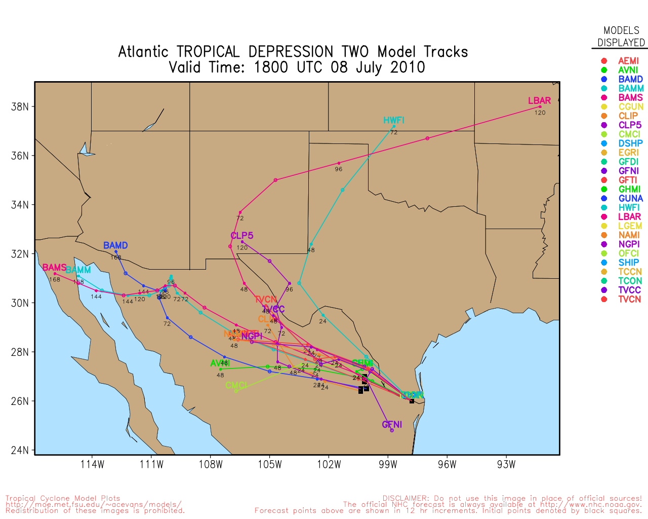
As of the 06Z model run. There are now 3 models in the Southern GOM at the 5 day point... , HWRF AND TVCN.
All three cross Cuba and move into the GOM after 3 1/2 days.
CLP5 crosses Cancun,MX and the three BAM models cross the lower/ mid Yucatan Peninsula.
Euro is outlier with a slow track toward Belize.
Latest 93L model plot here:
https://my.sfwmd.gov/sfwmd/common/images/weather/plots/storm_93.gif
See attachment for the 0515 rgb image. Lightning beginning to show in main cloud. Just south of Dominican Republic.
Edited by danielw (Tue Jun 22 2010 07:35 AM)
|
Storm Hunter
Veteran Storm Chaser
Reged:
Posts: 1370
Loc: Panama City Beach, Fl.
|
|
i would of expected the 00Z to move left.. instead it moved north and maybe east... the far right outlier... it also troubles me with what it does in the GOM in 5-6 days... but yet the HWF does a loop in central carib. and then takes left over to SE GOM... weird... until we get a surface feature... the models i think are going to move all over the place... the just stays calm with wave... very interesting to say/watch
http://moe.met.fsu.edu/tcgengifs/gfdl/2010062200-invest93l/slp21.png
--------------------
www.Stormhunter7.com ***see my flight into Hurricane Ike ***
Wx Data: KFLPANAM23 / CW8771
2012== 23/10/9/5 sys/strms/hurr/majh
|
Hugh
Senior Storm Chaser
Reged:
Posts: 1060
Loc: Okaloosa County, Florida
|
|
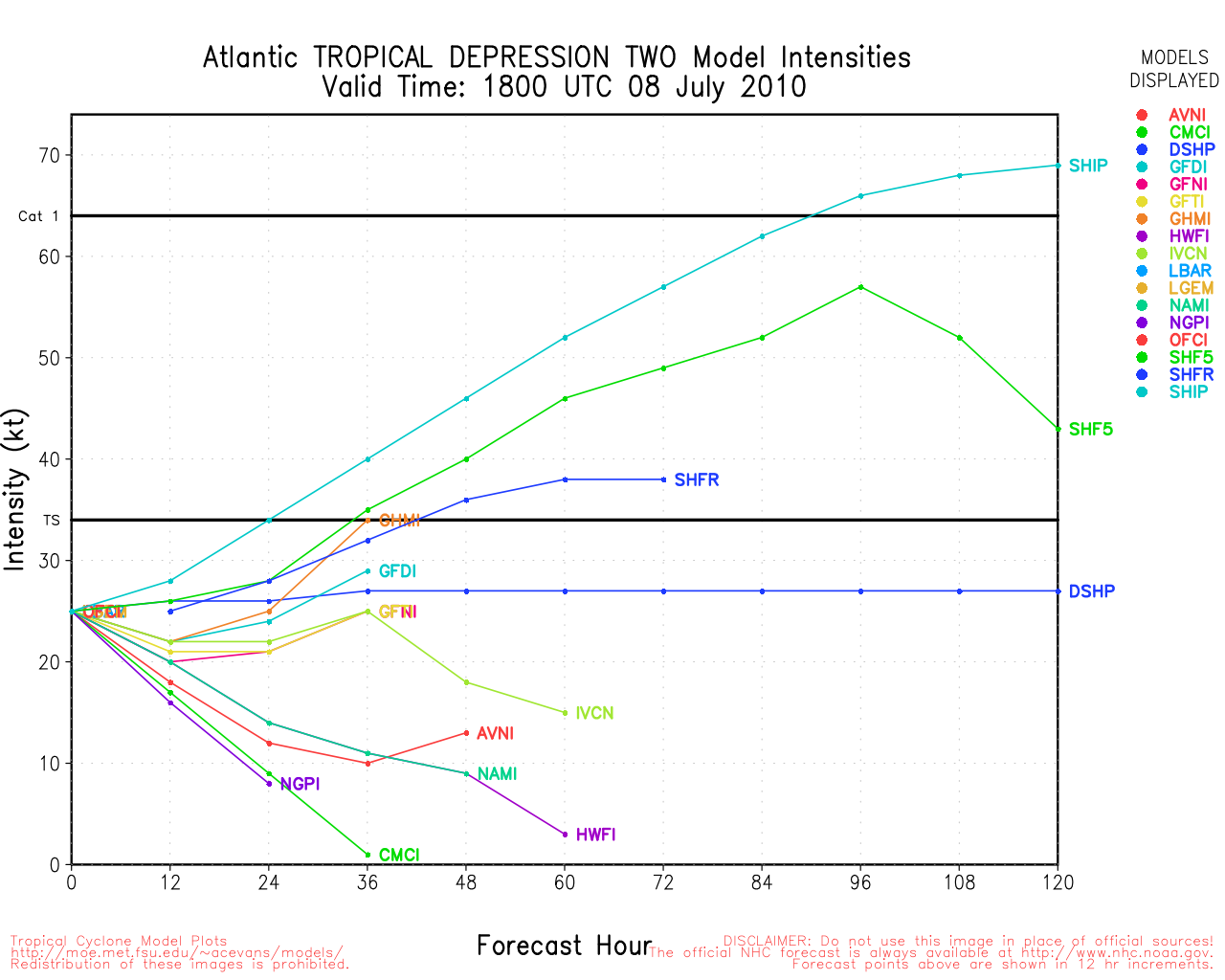
Well, the actually dropped the probability from 50% to 40% in the 8am . It's looking more ragged again today. They have yet to mention tomorrow's recon in the , which is curious.
GFDL and BAMS are a bit disturbing. No, they're very disturbing, still. HWRF is just wacked out.
Once it gets into the W. Caribbean things could pop in a big hurry, unfortunately.
--------------------
Hugh
Eloise (1975) - Elena and several other near misses (1985) - Erin & Opal (1995) - Ivan (2004)
|
Wingman51
Weather Guru

Reged:
Posts: 126
Loc: Orlando, FL
|
|
Just looked at and it is Whacked - - shows 2 systems training into the north gulf next week????
|
hogrunr
Weather Guru

Reged:
Posts: 153
Loc: Spring, TX
|
|
Looking at the RGB satellite loop, there is definitely more activity in 93L's lower levels this morning. Yesterday was definitely all and upper level spin, while today, even though I wouldn't call it an LLC, it definitely has more spin going in the lower level clouds.
Most of the models seem to be moving towards the system entering the central to western gulf alot more than they were yesterday. , HWRF, all of the system doing this. While I agree that the models won't really have a good grip on what the possibilities of this system are as long as it stays this unorganized, I take their shift westward in track as a sign they are starting to agree that the ridge that will be present over the northern GOM will not be leaving as soon as they believed, thus pushing the system further west.
Overall the system still is poised to be one that could make a rapid increase in intensity because of its location in the Caribbean and because of just about every other environmental variable around it.
|
scottsvb
Weather Master
Reged:
Posts: 1184
Loc: fl
|
|
I dont see any LLC with 93L its all SE and E winds until you get down in the SW carribean. What alot are seeing is the midlevel convergence T-Storms just south of Hispaniola. I dont think anything is close to forming for @ least 2-3 days until its closer to 80W
|
Beach
Weather Guru

Reged:
Posts: 187
Loc: Cocoa Beach/Banana River
|
|
If 93L holds together into the Gulf , I guess we will see the results of the debate of if oily water, can feed a system. Folks claim that oily water will not evaporate and help in keeping a system from growing. Currently the Gulf is 86 / 87 degrees, time will tell if that converts to tropical energy.
:?:
|


 Threaded


