Ed Dunham
Former Meteorologist & CFHC Forum Moderator (Ed Passed Away on May 14, 2017)
Reged:
Posts: 2565
Loc: Melbourne, FL
|
|
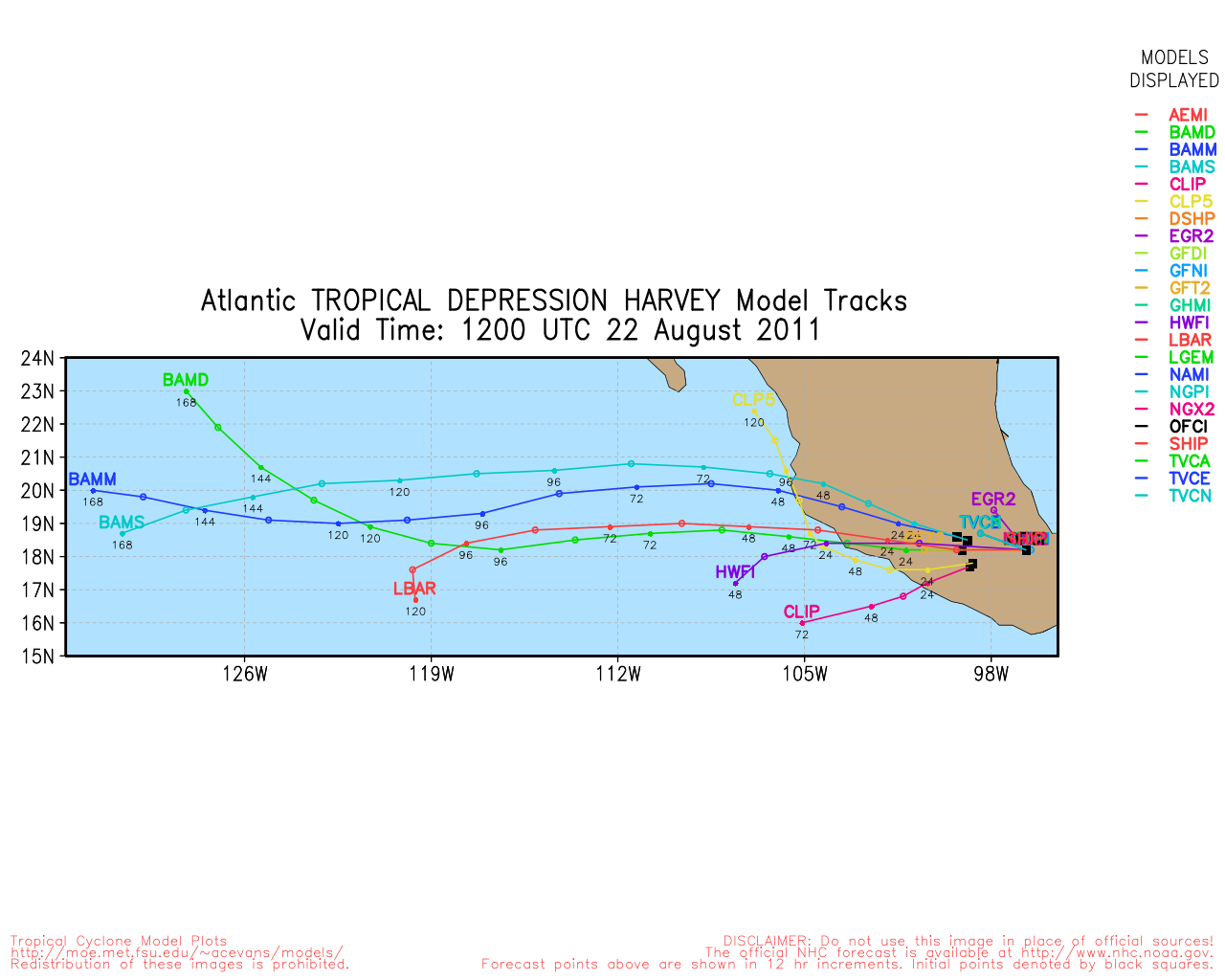
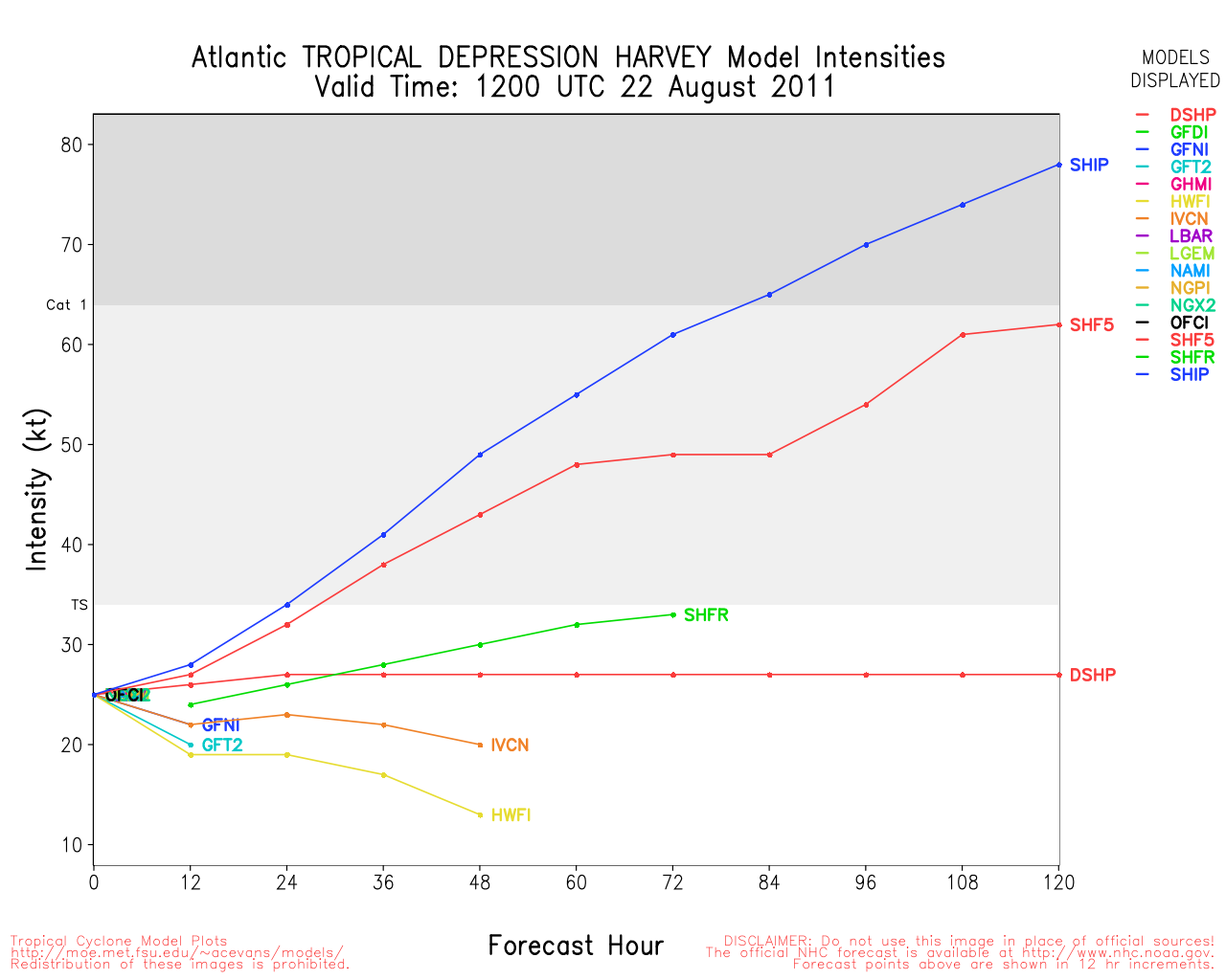
Update, Saturday, August 20th, 4PM EDT
Tropical Storm Harvey has made landfall near Dangriga Town in Belize. It is another named system this year to continue the streak of storms that have failed to reach hurricane strength. Hopefully this luck will continue with the system now nearing the Leeward islands in the Caribbean.

This system has a 90% chance to develop over the next two days, and likely will tonight or sometime tomorrow. Recon aircraft is currently in the system sampling it for any sign of a low level circulation center.
This system is large, and likely to grow slowly is still worth watching for those in Puerto Rico, Hispaniola, Eastern Cuba, the Southern Bahamas, Southeastern US Coasts, including Florida, and the North Central Gulf of Mexico coasts through the week. The more reliable models still have been persisting in the idea that it copuld possibly make landfall in the US, and odds still favor that it will. (Although at what strength is very uncertain, as it depends on the path it does or does not take over the Caribbean islands).
Once the system gets named and develops there may be a better idea on what this system may actually do, see the Forecast Lounge for more speculation on that.
Martinique Radar recording for 97l
Update, Saturday, August 20th, 745AM EDT
Harvey continues to strengthen and is now a 60MPH Tropical Storm moving west toward Belize, it is possible for Harvey to become this year's first hurricane, those along Belize may want to prepare for a category 1 hurricane approach. Officially, there are currently Tropical Storm Warnings up for the area.
97L has a 70% chance to become a storm or depression over the next two days, most likely tomorrow at the current rate. Odds with the long range models have persistently continued to favor some sort of land interaction with the Central Gulf or Florida (As opposed to a recurve) , and therefore it must be watched closely for late next week in the Southeast and Northern Gulf to see if the patterns persist. Once it develops there may be a better idea on what this system may actually do, see the Forecast Lounge for more speculation on that.
Those in the eastern Caribbean will want to watch the system extremely closely as it approaches over the next few days.
Update, Friday, August 19th, 2PM EDT
TD#8 was upgraded to Tropical Storm Harvey.
Also another wave in the far eastern Atlantic, off Africa was just designated Invest 99l.
Flhurricane Belize long term Radar recording of Harvey (2011) approach
Update, Friday, August 19th, 11AM EDT
Recon found a center a few miles further northeast, i.e., a little more offshore, so TD8 now has a better chance of becoming a Tropical Storm later tonight. The cyclone should pass over Roatan Island tonight with landfall in southern Belize on Saturday - possibly as a 50mph TS. Heavy rainfall likely over Honduras, Guatemala, Belize and portions of the Yucatan. Watches/Warnings are as follows:
A TROPICAL STORM WARNING IS IN EFFECT FOR...
* THE BAY ISLANDS OF HONDURAS
A TROPICAL STORM WATCH IS IN EFFECT FOR...
* THE COAST OF HONDURAS
* THE COAST OF GUATEMALA
* THE COAST OF BELIZE FROM DANGRIGA TOWN SOUTHWARD TO THE BELIZE/ GUATEMALA BORDER
* THE SOUTHEASTERN COAST OF THE YUCATAN PENINSULA FROM PUNTA GRUESA SOUTHWARD TO CHETUMAL
Invest 97L did develop additional convection during the night, however, a better organization has not occurred due to the rapid westward motion of the system.
ED
Update, Thursday, August 18th, 11PM EDT
Invest 93L has been upgraded to Tropical Depression 8, located over 400 miles east southeast of Belize City with sustained winds of 30 knots. The TD is moving to the west at 10 knots and has a limited timeframe to strengthen before interacting with the north shore of Honduras. Its going to be close as to whether the TD can attain Tropical Storm strength tonight or on Friday prior to final landfall in southern Belize.
There hasn't been any significant change to the structure of Invest 97L and a new system, Invest 98L, has emerged off the west African coast.
ED
Original Post
The system approaching the Western Caribbean Sea (Invest 93L) is a small system (so far that has been the standard for this season) with good convection and some lingering dry air to the west. The system is located southwest of Jamaica and well east of Roatan Island, Honduras, and is moving to the west at about 15 knots. Chances for additional development are high and the system could become a Tropical Depression later this evening or tonight. Probable threat areas include northern Honduras & Roatan Island, eastern Guatemala and Belize on Friday and Saturday.
Roatan Island, Honduras, Weather Conditions
San Jose, Guatemala, Weather Conditions
Belize City Weather Conditions
Belize Radar
Invest 97L is located in the central Atlantic midway between the Leeward Islands and the Cape Verde Islands and the system is moving westward. A building Atlantic ridge to the north of the Invest area should insure a continued west to west northwest track for many days, so the folks in the Leeward Islands should closely monitor this developing system. Convection is limited at the moment but the overall circulation area is large. With warm SSTs of 29-30C and a somewhat favorable upper air environment, a slow development trend seems appropriate. Invest 97L could become a long-track system.
Given the history of model performance on this system, it might be tempting for some posts to over-hype its expectations, but please don't do that. Keep in mind that the various models are a guidance to developing the future track and intensity forecasts for this system, but they are not the forecast itself. This Invest area is still weak and has many obstacles in its future path. Dry air to its north, an increasing forward speed as the Atlantic ridge strengthens, a zone of southerly windshear east of the Leewards and other potential landmass interactions could all have an impact on what, if anything, the eventual system becomes.
The Forecast Lounge is still the correct place for long range speculation on 97L's future track and intensity.
ED
Flhurricane Radar Recording of Martinique Radar (93L Approach)
Long term Central Atantic wide area Water Vapor Satellite for Hurricane Season Peak flhurricane)
Long term West Atantic wide area Water Vapor Satellite for Hurricane Season Peak flhurricane)
Edited by MikeC (Sat Aug 20 2011 09:41 PM)
|
JoshuaK
Weather Guru
Reged:
Posts: 159
Loc: Lakeland, FL
|
|
Advisories were started at 11PM for TD#3, which the is forecasting to strengthen into a minimal Tropical Storm while skirting along the coastline, before heading on in and dissipating later this week. 98L is looking a lot more organized on the latest satellite imagery, while 97L is still looking pretty frazzled.
|
WeatherNut
Weather Master
Reged:
Posts: 412
Loc: Atlanta, GA
|
|
several samples of 40mph+ winds. I'm pretty sure this is Harvey at 11am. Also the center is 35miles NE of where thought it was. Thats going to make a big difference as it will probably stay farther off shore longer
--------------------
Born into Cleo (64)...been stuck on em ever since
|
danielw
Moderator

Reged:
Posts: 3525
Loc: Hattiesburg,MS (31.3N 89.3W)
|
|
Just after WeatherNut's post. Recon transmitted this Vortex message. And no upgrade to Tropical Storm, yet.
Product: Air Force Vortex Message (URNT12 KNHC)
Transmitted: 19th day of the month at 14:17Z
Aircraft: Air Force Aircraft (Last 3 digits of the tail number are 302)
Tropical Depression: Number 8 (flight in the North Atlantic basin)
Mission Number: 3
Observation Number: 17
A. Time of Center Fix: 19th day of the month at 13:57:30Z
B. Center Fix Coordinates: 16°04'N 83°27'W (16.0667N 83.45W) (View map)
B. Center Fix Location: 262 miles (421 km) to the SSW (211°) from George Town, Cayman Islands (GBR).
C. Minimum Height at Standard Level: 1,459m (4,787ft) at 850mb
D. Estimated (by SFMR or visually) Maximum Surface Wind: 35kts (~ 40.3mph)
E. Location of the Estimated Maximum Surface Wind: 17 nautical miles (20 statute miles) to the N (356°) of center fix
F. Maximum Flight Level Wind Inbound: From 103° at 40kts (From the ESE at ~ 46.0mph)
G. Location of Maximum Flight Level Wind Inbound: 42 nautical miles (48 statute miles) to the N (354°) of center fix
H. Minimum Sea Level Pressure: 1005mb (29.68 inHg)
I. Maximum Flight Level Temp & Pressure Altitude Outside Eye: 15°C (59°F) at a pressure alt. of 1,538m (5,046ft)
J. Maximum Flight Level Temp & Pressure Altitude Inside Eye: 20°C (68°F) at a pressure alt. of 1,526m (5,007ft)
K. Dewpoint Temp (collected at same location as temp inside eye): 16°C (61°F)
K. Sea Surface Temp (collected at same location as temp inside eye): Not Available
L. Eye Character: Not Available
M. Eye Shape: Not Available
N. Fix Determined By: Penetration, Radar, Wind, Pressure and Temperature
N. Fix Level: 850mb
O. Navigation Fix Accuracy: 0.02 nautical miles
O. Meteorological Accuracy: 1 nautical mile
Remarks Section:
Maximum Flight Level Wind: 40kts (~ 46.0mph) in the north quadrant at 13:44:20Z
|
WeatherNut
Weather Master
Reged:
Posts: 412
Loc: Atlanta, GA
|
|
They waited till 2p for some reason, but its now upgraded to Harvey
--------------------
Born into Cleo (64)...been stuck on em ever since
|
MikeC
Admin
Reged:
Posts: 4544
Loc: Orlando, FL
|
|
Added: Flhurricane Belize long term Radar recording of Harvey (2011) approach
|
danielw
Moderator
Reged:
Posts: 3525
Loc: Hattiesburg,MS (31.3N 89.3W)
|
|
Storm 97L appears to be reforming it's Center. Current log10 spiral analysis indicates the center to be near 14.5N/ 56.0W.

|
WesnWylie
Weather Guru
Reged:
Posts: 155
Loc:
|
|
97L is really looking good this morning. It's sitting in an area of low shear. The only thing that may interrupt 97L is dry air directly ahead of it. At this time, I don't really see it being much of an issue, though. I have a feeling we will see Tropical Depression 9 form within the next 24 hours.
--------------------
2011 Season Forecast: 16/09/04
2011 Systems: 10/01/01
|
danielw
Moderator
Reged:
Posts: 3525
Loc: Hattiesburg,MS (31.3N 89.3W)
|
|
Product: Air Force Vortex Message (URNT12 KNHC)
Transmitted: 20th day of the month at 14:25Z
Aircraft: Air Force Aircraft (Last 3 digits of the tail number are 309)
Storm Number & Year: 08L in 2011
Storm Name: Harvey (flight in the North Atlantic basin)
Mission Number: 5
Observation Number: 16
A. Time of Center Fix: 20th day of the month at 13:58:30Z
B. Center Fix Coordinates: 16°50'N 87°26'W (16.8333N 87.4333W) (View map)
B. Center Fix Location: 68 miles (109 km) to the SE (133°) from Belize City, Belize.
C. Minimum Height at Standard Level: 1,432m (4,698ft) at 850mb
D. Estimated (by SFMR or visually) Maximum Surface Wind: 27kts (~ 31.1mph)
E. Location of the Estimated Maximum Surface Wind: 41 nautical miles (47 statute miles) to the SW (218°) of center fix
F. Maximum Flight Level Wind Inbound: From 282° at 33kts (From the WNW at ~ 38.0mph)
G. Location of Maximum Flight Level Wind Inbound: 29 nautical miles (33 statute miles) to the SW (224°) of center fix
H. Minimum Sea Level Pressure: 999mb (29.50 inHg)
I. Maximum Flight Level Temp & Pressure Altitude Outside Eye: 14°C (57°F) at a pressure alt. of 1,524m (5,000ft)
J. Maximum Flight Level Temp & Pressure Altitude Inside Eye: 18°C (64°F) at a pressure alt. of 1,527m (5,010ft)
K. Dewpoint Temp (collected at same location as temp inside eye): 11°C (52°F)
K. Sea Surface Temp (collected at same location as temp inside eye): Not Available
L. Eye Character: Not Available
M. Eye Shape: Not Available
N. Fix Determined By: Penetration, Radar, Wind, Pressure and Temperature
N. Fix Level: 850mb
O. Navigation Fix Accuracy: 0.02 nautical miles
O. Meteorological Accuracy: 2 nautical miles
Remarks Section:
Maximum Wind Outbound: 61kts (~ 70.2mph) in the north quadrant at 13:59:30Z
Maximum Flight Level Wind: 61kts (~ 70.2mph) in the north quadrant at 13:59:30Z
|
danielw
Moderator
Reged:
Posts: 3525
Loc: Hattiesburg,MS (31.3N 89.3W)
|
|
97 L appears to be forming a , central dense overcast. Looks like a short term watch/ warning scenario might be in play here.
Heads up in the Lesser Antilles.
Recon will be flying the system later today. It could go to a named Tropical Storm at that time.

|
mwillis
Weather Hobbyist

Reged:
Posts: 68
Loc: Cape canaveral
|
|
looking at the image from um-ciss, at 55.1 and 14.5 could that be the LLC? im using the 1km image.
http://tropic.ssec.wisc.edu/real-time/st...0000&loop=0
|
Ed Dunham
Former Meteorologist & CFHC Forum Moderator (Ed Passed Away on May 14, 2017)
Reged:
Posts: 2565
Loc: Melbourne, FL
|
|
I think that your position would be rather close. At 20/12Z, used 14.3N 54.9W. The convective ball is on the western edge of the circulation. Still some easterly shear, and what appears to be a jog to the WNW.
ED
|
weathernet
Storm Tracker
Reged:
Posts: 296
Loc: Elsewhere
|
|
In addition to recon, looks like we have a bouy ( #41101 ) nearly right in the path of 97L. I think if west winds were detected along with falling pressure, than ample data would exist to permit an upgrade to depression ( regardless of recon ). I do not yet believe that the west winds will be found at the surface, perhaps close though.
Looks to me however, that the fast forward motion along with a light southerly component of shear, might still be a temporary hinderance to 97L being upgraded at the ( or prior too ) 3:00pm recon fix. Looks to my eyes, that a LLC might be trying to form under the small at about 14.8 N & 56 W. HOWEVER...., I believe that a reforming LLC will actually emerge farther north between 16 - 17 N under what I believe may be the mid level vortex which appears to be moving on a more WNW direction. Given the excellent mid level structure as exhibited since yesterday, it would appear that the only reason that the system is not already better vertically stacked, is due to the ongoing attempt for a LLC to form, yet getting "stretched" away due to the lower level flow being somewhat more westerly ( and contrary to the mid level wanting to move more WNW at the same time ).
Given improving upper air & and oceanic heat dynamics, the prospects for the system deepening would appear to be getting better as it continues along. My guess is that recon will record some fairly high gusts in squalls ( perhaps 40-50 knots? ) on the northern quadrant of the overall system, but still fall short of being able to close off a surface low. I would expect that convective bursting later this afternoon or evening might just help bring a tilted LLC to the surface and perhaps might occur before nights end.
Tricky situation, given the strength and size of the wave, and its proximity to the islands ( regardless where the ultimate center forms ).
|
scottsvb
Weather Master
Reged:
Posts: 1184
Loc: fl
|
|
Mike or Ed .. can we get the 97L Mart radar approach up? There are squalls from the elongated center already in Barbados.
The LLC is primarily down near Barbados around 13.2N 60.2W elongated easterward to around 12.5N and 58W while another (not closed) low with a midlevel feature around 14.5N 57.5W
Probably consolidate later on Sunday and a Depression will be classified then unless they determine there is a closed circulation near 60W
|
danielw
Moderator
Reged:
Posts: 3525
Loc: Hattiesburg,MS (31.3N 89.3W)
|
|
4 image loop. Not much detail.
http://www.meteo.fr/temps/domtom/antilles/pack-public/animation/animMOSAIC2.html
|
MikeC
Admin
Reged:
Posts: 4544
Loc: Orlando, FL
|
|
Added Martinique Radar recording for 97l
|
Hugh
Senior Storm Chaser
Reged:
Posts: 1060
Loc: Okaloosa County, Florida
|
|
Recon appears to be finding some high winds at the surface (50kts), but no vortex message has been transmitted yet, and there's no north winds from what I can tell - or not very many, at any rate (but the radar shows an apparent LLC).
--------------------
Hugh
Eloise (1975) - Elena and several other near misses (1985) - Erin & Opal (1995) - Ivan (2004)
Edited by Hugh (Sat Aug 20 2011 08:46 PM)
|
WeatherNut
Weather Master
Reged:
Posts: 412
Loc: Atlanta, GA
|
|
Looks like recon just found some west winds...this might go straight to Irene if indeed a center is found
--------------------
Born into Cleo (64)...been stuck on em ever since
|
MikeC
Admin
Reged:
Posts: 4544
Loc: Orlando, FL
|
|
The best track has 45 knot winds, but was still an invest. That's before recon found the westerlies. It's splitting hairs at this point, call or no call it's about at that point, and would go straight to Irene if it gets done. So it may get named today based on that alone. The thing going against an upgrade right now is that it's just not all that well defined, large, but not well defined.
|
danielw
Moderator
Reged:
Posts: 3525
Loc: Hattiesburg,MS (31.3N 89.3W)
|
|
I see the West winds. Might need SW winds to go straight to Irene. Sure looks like they have closed a Low off.
It's close...
Close to Barbados also.
|


 Threaded


