Joeyfl
Weather Guru

Reged:
Posts: 133
Loc: St.Pete,FL
|
|
Looking at recon and winds it looks like we have a closed low, awaiting for statement.....
|
MikeC
Admin
Reged:
Posts: 4544
Loc: Orlando, FL
|
|
Looks like we have a number for it, at least.
BEGIN
NHC_ATCF
INVEST_RENUMBER_al912013_al012013.ren
FSTDA
R
U
040
010
0000
201306052121
NONE
NOTIFY=ATRP
END
INVEST, AL, L, , , , , 01, 2013, DB, O, 2013060300, 9999999999, , , , , , WARNING, 1, AL012013
AL, 01, 2013060418, , BEST, 0, 239N, 870W, 25, 1009, DB, 0, , 0, 0, 0, 0, 1010, 225, 150, 0, 0, L, 0, , 0, 0, INVEST, S,
AL, 01, 2013060500, , BEST, 0, 243N, 870W, 25, 1008, DB, 0, , 0, 0, 0, 0, 1009, 210, 150, 0, 0, L, 0, , 0, 0, INVEST, S,
AL, 01, 2013060506, , BEST, 0, 246N, 870W, 25, 1008, DB, 0, , 0, 0, 0, 0, 1009, 210, 150, 0, 0, L, 0, , 0, 0, INVEST, S,
AL, 01, 2013060512, , BEST, 0, 249N, 869W, 30, 1007, DB, 0, , 0, 0, 0, 0, 1009, 250, 200, 40, 0, L, 0, , 0, 0, INVEST, M,
AL, 01, 2013060518, , BEST, 0, 253N, 866W, 35, 1006, DB, 34, NEQ, 50, 120, 0, 0, 1010, 250, 120, 45, 0, L, 0, , 0, 0, INVEST, M,
|
Joeyfl
Weather Guru
Reged:
Posts: 133
Loc: St.Pete,FL
|
|
Andrea is born, advisory out soon.
|
danielw
Moderator

Reged:
Posts: 3525
Loc: Hattiesburg,MS (31.3N 89.3W)
|
|
URNT12 KBIX 052132
VORTEX DATA MESSAGE AL912013
A. 05/20:53:20Z
B. 25 deg 11 min N
086 deg 38 min W
C. NA
D. 30 kt
E. 310 deg 27 nm
F. 057 deg 36 kt
G. 303 deg 20 nm
H. EXTRAP 1005 mb
I. 21 C / 243 m
J. 25 C / 242 m
K. 24 C / NA
L. NA
M. NA
N. 1345 / 01
O. 0.02 / 1 nm
P. AF303 01AAA INVEST OB 10
MAX FL WIND 47 KT 069/49 19:43:00Z
SLP EXTRAP FROM BELOW 1500 FT
appears to be warm core 25 C
AMENDED VORTEX
Product: Air Force Vortex Message (URNT12 KBIX)
Disseminated Through: Keesler AFB, backup for KNHC (TPC/NHC)
Transmitted: 5th day of the month at 21:54Z
Aircraft: Air Force Aircraft (Last 3 digits of the tail number are 303)
Mission Purpose: Investigate first suspect area (flight in the North Atlantic basin)
Mission Number: 1
Observation Number: 13
A. Time of Center Fix: 5th day of the month at 21:39:30Z
B. Center Fix Coordinates: 25°10'N 86°34'W (25.1667N 86.5667W) (View map)
B. Center Fix Location: 303 miles (488 km) to the W (278°) from Key West, FL, USA.
C. Minimum Height at Standard Level: Not Available
D. Estimated (by SFMR or visually) Maximum Surface Wind: 25kts (~ 28.8mph)
E. Location of the Estimated Maximum Surface Wind: 24 nautical miles (28 statute miles) to the NW (305°) of center fix
F. Maximum Flight Level Wind Inbound: From 35° at 28kts (From the NE at ~ 32.2mph)
G. Location of Maximum Flight Level Wind Inbound: 18 nautical miles (21 statute miles) to the WNW/NW (304°) of center fix
H. Minimum Sea Level Pressure: 1002mb (29.59 inHg) - Extrapolated
I. Maximum Flight Level Temp & Pressure Altitude Outside Eye: 22°C (72°F) at a pressure alt. of 244m (801ft)
J. Maximum Flight Level Temp & Pressure Altitude Inside Eye: 24°C (75°F) at a pressure alt. of 274m (899ft)
K. Dewpoint Temp (collected at same location as temp inside eye): 24°C (75°F)
K. Sea Surface Temp (collected at same location as temp inside eye): Not Available
L. Eye Character: Not Available
M. Eye Shape: Not Available
N. Fix Determined By: Penetration, Wind, Pressure and Temperature
N. Fix Levels (sfc and flt lvl centers are within 5nm of each other): Surface and 1,500 feet
O. Navigational Fix Accuracy: 0.02 nautical miles
O. Meteorological Accuracy: 2 nautical miles
Remarks Section - Remarks That Were Decoded...
Maximum Flight Level Wind: 47kts (~ 54.1mph) in the quadrant at 0:66
Sea Level Pressure Extrapolation From: Below 1,500 feet
Remarks Section - Additional Remarks...
MAX FL WIND 47 KT 066/45 19:43:00Z
Edited by danielw (Wed Jun 05 2013 10:14 PM)
|
vineyardsaker
Weather Guru

Reged:
Posts: 150
Loc: New Smyrna Beach, FL
|
|
The current HypeScale is at 2.1 - why is that the case? Do current conditions which include "Potential Depression/Tropical Storm US land impact" not warrant a 4+ HypeScale? Does that indicate that Andrea is really weak or are we being too slow to start paying attention to what is happening?
Cheers!
--------------------
Charley(eyewall), Ivan, Jeanne, Dennis, Wilma, Irma, Ian (eyewall), Nicole
|
MikeC
Admin
Reged:
Posts: 4544
Loc: Orlando, FL
|
|
Hypescale is fairly unscientific and measures media response more than anything.
Strong cells are over the Dry Tortugas west of the Keys, and another strong rain band is approaching Venice on the west coast of Florida tonight. Most of the bad stuff is still offshore at the moment, though.
|
JoshuaK
Weather Guru
Reged:
Posts: 159
Loc: Lakeland, FL
|
|
I'll be out working in this for the next couple of nights. I hope nothing too strong blows through, I'm not sure how much our guard shack can take.
|
MikeC
Admin
Reged:
Posts: 4544
Loc: Orlando, FL
|
|
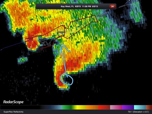
The Keys are getting it tonight, tornado near 7 Mile bridge, and another approaching Marathon.
|
danielw
Moderator
Reged:
Posts: 3525
Loc: Hattiesburg,MS (31.3N 89.3W)
|
|
Initial pass from RECON.
Looks like the estimated Center has moved about 45 miles due north. Or just a hair east of due north.
I'm waiting on the NE to SW pass about 90 minutes from now to confirm Center location.
Center Dropsonde location. Estimated center~danielw
Coordinates: 26.7N 86.2W
Location: 246 miles (396 km) to the WSW (249°) from Tampa, FL, USA.
Edited by danielw (Thu Jun 06 2013 05:28 AM)
|
danielw
Moderator
Reged:
Posts: 3525
Loc: Hattiesburg,MS (31.3N 89.3W)
|
|
Product: Air Force Vortex Message (URNT12 KNHC)
Transmitted: 6th day of the month at 05:51Z
Aircraft: Air Force Aircraft (Last 3 digits of the tail number are 303)
Storm Number & Year: 01L in 2013
Storm Name: Andrea (flight in the North Atlantic basin)
Mission Number: 2
Observation Number: 04
A. Time of Center Fix: 6th day of the month at 5:01:10Z
B. Center Fix Coordinates: 26°39'N 86°13'W (26.65N 86.2167W)
B. Center Fix Location: 248 miles (399 km) to the WSW (248°) from Tampa, FL, USA.
C. Minimum Height at Standard Level: 1,432m (4,698ft) at 850mb
D. Estimated (by SFMR or visually) Maximum Surface Wind: 31kts (~ 35.7mph)
E. Location of the Estimated Maximum Surface Wind: 22 nautical miles (25 statute miles) to the NW (307°) of center fix
F. Maximum Flight Level Wind Inbound: From 53° at 38kts (From the NE at ~ 43.7mph)
G. Location of Maximum Flight Level Wind Inbound: 40 nautical miles (46 statute miles) to the NW (309°) of center fix
H. Minimum Sea Level Pressure: 1002mb (29.59 inHg)
I. Maximum Flight Level Temp & Pressure Altitude Outside Eye: 16°C (61°F) at a pressure alt. of 1,528m (5,013ft)
J. Maximum Flight Level Temp & Pressure Altitude Inside Eye: 18°C (64°F) at a pressure alt. of 1,526m (5,007ft)
K. Dewpoint Temp (collected at same location as temp inside eye): 17°C (63°F)
K. Sea Surface Temp (collected at same location as temp inside eye): Not Available
L. Eye Character: Not Available
M. Eye Shape: Not Available
N. Fix Determined By: Penetration, Wind, Pressure and Temperature
N. Fix Level: 850mb
O. Navigational Fix Accuracy: 0.02 nautical miles
O. Meteorological Accuracy: 6 nautical miles
Remarks Section:
MAX OUTBOUND AND MAX FL WIND 53 KT 132/68 05:21:50Z
Center temperatures have dropped quite a bit. The highest temp was 25 C. On the first mission. But it is night time.~danielw
|
berrywr
Weather Analyst

Reged:
Posts: 387
Loc: Opelika, AL
|
|
Dual Pol allows us to look at what are called rotational/dual velocity couplets. There were two TVS - tornadic vortex signatures. If you have the grlevelx radar software you can view even the debris balls.
--------------------
Sincerely,
Bill Berry
"Survived Trigonometry and Calculus I"
|
doug
Weather Analyst
Reged:
Posts: 1006
Loc: parrish,fl
|
|
Current Sat. trends seem to indicate that the direction will take Andrea over Pasco/Hernando counties as point of initial land fall and that the dominant direction is more ENE than NE. Also, as the day dawns the squall line approaching the coast line is intensifying and increasing in coverage. Some significant impact can be expected well removed from the center as is usual in fledgling storms such as this.
--------------------
doug
|
scottsvb
Weather Master
Reged:
Posts: 1184
Loc: fl
|
|
Yeah it took a wobble that direction...still think it will be up closer to Citrus or Levi but wouldn't shock me if it's down 1 county. Not alot of wind in the overall rain mass..maybe 10-15mph...general rainstorm...almost no lightning..very typical for a warm core system. Though winds will pick up as Andrea moves over the coast by later in the afternoon..expect winds to increase 20-30mph and will be around 40-50 near and to the right of her landfall. Still main threat is Tornados and Flooding. SS should only be 2ft but parts of Tampa's LL areas might get overflow from the bay...and up the coast
|
|


 Threaded


