cieldumort
Moderator

Reged:
Posts: 2305
Loc: Austin, Tx
|
|
A vigorous and convectively active portion of a broad low pressure with a few embedded smaller-scale vorticity maximas out in the Tropical Atlantic Main Development Region (MDR) has increasing model support, now including both of the primary Globals (GFS and ) for development, and as such we are starting a Lounge on this feature at this time.
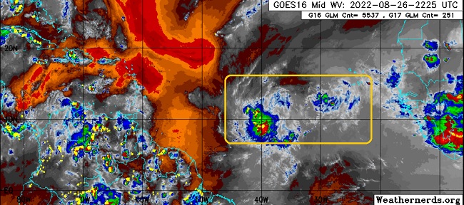
For clarification, as mentioned above and highlighted in the image, this feature actually includes more than one potential center - even more than one potential TD in the making. sort of blends both the two main 'centers' together for tracking, as it does seem likely that one will become dominant, and perhaps also the sole feature.
An Invest number has not yet been issued, but if current trends continue, one could be up as early as this weekend.
More details to come.
The complex area of low pressure we have been tracking has consolidated enough for an Invest tag tonight and is now being tracked as Invest 91L. 8/27/22. Tropical Storm Earl 9/2/22 -Ciel
|
cieldumort
Moderator
Reged:
Posts: 2305
Loc: Austin, Tx
|
|
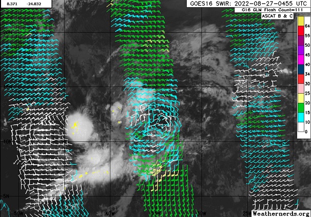
The broad area of low pressure has been tracking continues to consolidate, with a somewhat well defined primary surface low center now presenting itself as can be seen in the above image courtesy Weathernerds.org, and we could see an Invest tag with higher resolution model runs soon.
The apparent primary low is at the moment benefiting from enhanced humidity and instability associated with a convectively active phase of the that is pulling away to the east, and as it continues to do so, consolidation will probably continue as the outer reaches of the broad low begin to evaporate in the unseasonably hostile and dry tropical Atlantic. The big question then, is does whatever remain even survive long enough to become a T.C., and secondly, if so, while in the MDR, or perhaps pops closer to land?
As for the models, most including the Euro seem to develop this one, while the has suddenly backed off.
|
MikeC
Admin
Reged:
Posts: 4544
Loc: Orlando, FL
|
|
Models today have shown later development for this system, the 18Z shows a bend back toward the west after looking almost like a recurve, and the 12Z euro slows it down and bends back southwest at the end of its run near the Bahamas. Most Ensembles do keep it out to sea however, but there's not a lot of confidence in that because a well defined center has yet to form, and the is also insisting on western Caribbean development starting wednesday (latest run pushes a major into Brownsville with it), yet no other model shows anything close. The 18Z actually shows 91L with a landfall as a cat 2/3 hurricane near Myrtle Beach, SC on the 8th.
|
cieldumort
Moderator
Reged:
Posts: 2305
Loc: Austin, Tx
|
|
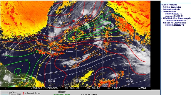
Conditions for development are not looking very pretty for our "Main Development Region" Invest 91L. The air is increasingly dry, and the shear is increasingly high, and the window for significant development, and by significant we are talking *T.D.* here, not necessarily a hurricane let alone named storm, in the near term, may actually be going downhill. In fact, the environment could become so hostile that the fledgling system just poofs like so many before it. We have seen healthier systems this year not get declared a T.D. at all.
One other potential hurdle for 91L is the possibility advertised by the of a beefy W Caribbean-SW Gulf named storm producing a great deal of enhancement in the upper atmosphere, such that shear only increases even more on whatever 91L may be by the end of the coming week.
This has not been a year for disturbances to thrive in the MDR, despite all the usual stars having come into alignment early on to suggest a banner MDR year was coming.
|
cieldumort
Moderator
Reged:
Posts: 2305
Loc: Austin, Tx
|
|
Invest 91L, hampered by less than ideal let alone seasonably favorable conditions in the Main Development Region, is now on approach to the northern Leeward Islands and very arguably a Tropical Storm. This puts the northern Leewards and Greater Antilles at threat for either a low-end tropical storm if held in check and continuing along a more southerly track, or possibly even something more, later, if the apparent sheared cyclone does not strengthen enough to feel the tug up and away back out to sea fast enough.
Several recon flights today and tonight are going to be fed into models and as there is now a coherent system (I would argue sheared tropical storm) runs are more apt to have a greater level of accuracy than prior runs focusing on a broad low with several competing globules of vorticity.
0z model runs will be shared here later tonight and early tomorrow on what will by then likely be SIX or Earl.
|
|


 Threaded


