MikeC
Admin
Reged:
Posts: 4544
Loc: Orlando, FL
|
|
Big model shifts west tonight as Euro went way west with a landfall in West Palm Beach, did as well, but only Clips the outer banks after moving through the Central Bahamas. goes through Florida and landfalls also in Lousiana.
Hispaniola looks to get very large amounts of rainfall, but it's likely Fiona will slip south of the USVI and Puerto Rico, but still close enough to bring rain.
|
MikeC
Admin
Reged:
Posts: 4544
Loc: Orlando, FL
|
|
Models are in a bit of chaos with the storm effectively moving faster and further south. Generally the idea for the longer term is if it gets picked up by the weakness or not. It's marginal now, which is why models have been going left and right during the runs. At the moment it's more to the right, but with Fiona already further west and slightly south than the runs, it could shift back the other way again. And may flip flop for a while until we know what happens with Hispaniola.
Currently the 6z turns right in the Dominican republic and barely misses the Turks and caicos to the east then cuts right and gets close to bermuda. 18Z yesterday had it scraping the Outer Banks. 0z had it moving faster. Telling is the 6z position is already slightly off for where it is now. So the chances of it flip flopping are good.
0z Euro gets into the Central bahamas and then north, but then cuts back left, moving tremendously slowly at the time, showcasing the uncertainty. 12Z yesterday had a West Palm beach Florida landfall. So this too is flip flopping
0z Canadian goes through the southeastern Bahamas, then cuts up close to the Outer Banks before turning out to sea. 12Z yesterday had a Florida then New Orelans Landfall. So this too is flip flopping. The track still looks pretty solid, however.
The TVCN consensus has been trending west, with some minor shifting right and left during that time.
Ensembles are spread, with the general trend of stronger runs tend to turn north and weaker are more west. The 6z EPS run this morning shows that well.
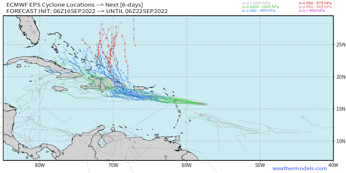
There's too much chaos in model trends between runs beyond the Caribbean right now to take anything as solid. So in short Bahamas, the US East coast and Bermuda need to keep watch on it until things clear up. With Fiona moving this quickly and weak, it's in a marginal setup to recurve or not right now.
|
MikeC
Admin
Reged:
Posts: 4544
Loc: Orlando, FL
|
|
0z turns a bit earlier, this time it actually gets Fiona to hurricane strength right before crossing the western side of Puerto Rico. If the strengthing trend that's been happening tonight continues, I wouldn't be surprised to see hurricane watches or warnings go up for Puerto Rico in the morning.
|
cieldumort
Moderator

Reged:
Posts: 2305
Loc: Austin, Tx
|
|
There were some slight south-of-west jogs during recon tonight, with the flight finding some subtle stair-stepping down (south) when Fiona enters a strengthening phase, which is noteworthy. Longer-term, smoothed-out track generally 280 degrees per analysis. Odds still favor the stronger the Fiona, the earlier and more pronounced the recurve prior to threatening .. But this is not a given. Regardless, P.R. almost certainly now is at much greater risk of a direct strong tropical storm to major hurricane impact.
Some 0z updated runs:
HWRF - Reasonably good initialization. 70KT hurricane by Saturday night. Landfall southeast coast of P.R. as a Cat 1/2 Sunday morning. Recurves after crossing P.R., resumes intensifying - Major Cat 3/4 east of the Bahamas and stays major while tracking generally either side of north through end of run.
HMON - May have initialized a touch north, but not terribly off. Probably a borderline Cat 1 by midday Saturday. Majors overnight Saturday/predawn Sunday on approach to P.R. Rakes P.R. while the center crosses the southwestern side of the island as a Cat 1/2. Passes through the gap between PR and Hispaniola, with another landfall on extreme eastern Hispaniola as Cat 1/2 Sunday night. Majors on approach to the eastern Bahamas. Strikes the eastern Bahamas at Cat 2/3 before hooking N-NNE as a Major.
ECMWF - May have initialized a bit north. Likely Cat 1 by late Saturday night. Strong Trop Storm/Cat 1borderline south of Ponce, PR Sunday morning. Landfall Sunday afternoon in southwestern P.R. as a strong Trop Storm or maybe Cat 1, then a landfall on eastern Hispaniola predawn Monday Cat 1. Apparent Cat 2 across eastern Bahamas Tuesday. Recurves and misses Bermuda to the west while likely undergoing Rapid Intensification on Friday. Landfall in vicinity of Halifax, Nova Scotia early Saturday morning with sub-940mb levels and widespread coastal gusts in excess of 100MPH.
GFS - May have initialized a touch too far northeast and a touch weak. Strong Tropical Storm on approach to eastern P.R. Landfall on the center of the island around dawn Sunday, still as a strong Trop Storm. Tracks NW towards eastern Bahamas, but begins hooking north prior to impacting them. Tracks west of Bermuda as a strong hurricane, and then out to sea. The wind-pressure relationship in this run looks suspect.
|
|


 Threaded


