cieldumort
Moderator

Reged:
Posts: 2305
Loc: Austin, Tx
|
|
Recon, something we did not have much benefit of the past 48 hours as flights were focusing on Fiona, has spent a great deal of time in Ian today, and the data is significant.
The first thing of note, is that Ian is rather troffy, with possibly still multiple swirls, or "centers," old and new, rotating about a midpoint of the troffy-storm. In addition, it still seems be feeling the push possibly a little bit more southward than largely forecast by the narrow ridge to its north. Finally, the pressure does not yet seem to be falling, and winds are not picking up.
All the above taken together casts further doubt on the reliability of the near unanimous model consensus of a direct Florida west coast landfall. The minority reports, the outliers initially weaker and then further left (west) in the long-range, clearly have some validity.
In fact, there has only been one VDM so far today, from 1042z, predawn and many hours ago, that fixed way down at 13.54N 74.58W, and on its own did not make a compelling case for tropical storm intensity.
Quote:
A. Time of Center Fix: 24th day of the month at 10:42:29Z
B. Center Fix Coordinates: 13.54N 74.58W
D. Minimum Sea Level Pressure: 1006mb (29.71 inHg)
L. Estimated (by SFMR or visually) Maximum Surface Wind Outbound: 32kts (36.8mph)
M. Location & Time of the Estimated Maximum Surface Wind Outbound: 134 nautical miles (154 statute miles) to the NNE (30°) of center fix at 11:16:28Z
Q. Maximum Flight Level Temp & Pressure Altitude Inside Eye: 19°C (66°F) at a pressure alt. of 1,541m (5,056ft)
R. Dewpoint Temp (collected at same location as temp inside eye): 18°C (64°F)
S. Fix Determined By: Penetration and Wind
Remarks Section:
Maximum Flight Level Wind: 31kts (~ 35.7mph) which was observed 138 nautical miles (159 statute miles) to the NNE (30°) from the flight level center at 11:17:18Z
Maximum Flight Level Temp: 19°C (66°F) which was observed 12 nautical miles (14 statute miles) to the NNE (30°) from the flight level center
0z models out later tonight may respond in meaningful way. Track and intensity remain in play, particularly track, as Ian is still more likely than not to become a Major. But a Florida peninsula landfall, maybe not so locked in. We can certainly hope not, for the probable strength and size of Ian around that time could be devastating for locations such as the Keys and Tampa.
|
GeorgeN
Weather Watcher

Reged:
Posts: 33
Loc: Wesley Chapel FL
|
|
Quote:
Recon, something we did not have much benefit of the past 48 hours as flights were focusing on Fiona, has spent a great deal of time in Ian today, and the data is significant.
.
Agreed. Recon will be a big factor in nailing down a better starting position for the Euro models. So far, this type of storm has been problematic for the Euro model as it really requires a good starting point/storm center. This has always been the Euro's Achilles's heel. Not to say I'm a big fan, but it has been reacting to the Westerly drift and disorganized center with less erratic plot changes.
I see the ECMF plot has finally popped up on the SWFMD tracks. Now showing landfall North of Tampa in the Cedar Key region.
--------------------
Wesley Chapel FL - since 1990
Previous resident of North Miami and Merritt Island
|
cieldumort
Moderator
Reged:
Posts: 2305
Loc: Austin, Tx
|
|
Most recent VDM suggests Ian is still attempting to consolidate a stable center and has not gotten any stronger.
Quote:
Product: Air Force Vortex Message (URNT12 KNHC)
Transmitted: 24th day of the month at 20:21Z
Agency: United States Air Force
Aircraft: Lockheed WC-130J Hercules with reg. number AF97-5303
Storm Name: Ian
Storm Number & Year: 09 in 2022 (flight in the North Atlantic basin)
Mission Number: 4
Observation Number: 23
A. Time of Center Fix: 24th day of the month at 19:42:40Z
B. Center Fix Coordinates: 14.37N 76.77W
D. Minimum Sea Level Pressure: 1007mb (29.74 inHg)
H. Estimated (by SFMR or visually) Maximum Surface Wind Inbound: 22kts (25.3mph)
I. Location & Time of the Estimated Maximum Surface Wind Inbound: 9 nautical miles to the WSW (245°) of center fix at 19:39:30Z
L. Estimated (by SFMR or visually) Maximum Surface Wind Outbound: 25kts (28.8mph)
M. Location & Time of the Estimated Maximum Surface Wind Outbound: 1 nautical miles to the NE (37°) of center fix at 19:43:00Z
P. Maximum Flight Level Temp & Pressure Altitude Outside Eye: 17°C (63°F) at a pressure alt. of 1,525m (5,003ft)
Q. Maximum Flight Level Temp & Pressure Altitude Inside Eye: 18°C (64°F) at a pressure alt. of 1,520m (4,987ft)
Remarks Section:
Maximum Flight Level Wind: 44kts (~ 50.6mph) which was observed 56 nautical miles (64 statute miles) to the NW (320°) from the flight level center at 19:04:30Z
Maximum Flight Level Temp: 18°C (64°F) which was observed 10 nautical miles (12 statute miles) to the WSW (245°) from the flight level center
|
MikeC
Admin
Reged:
Posts: 4544
Loc: Orlando, FL
|
|
18z Icon shifts right from to a Cat 3 landfall just south of Venice, FL last model run had it at Cedar key at 12Z.
18z starts off too far south based on recon, but still manages to stay east of the 12Z, but landfalls only about 35-40 miles east of the 12Z position in the panhandle. It rapidly weakens from shear as it approaches the panhandle.
|
cieldumort
Moderator
Reged:
Posts: 2305
Loc: Austin, Tx
|
|
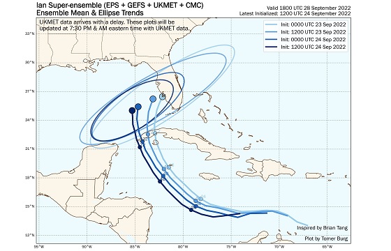
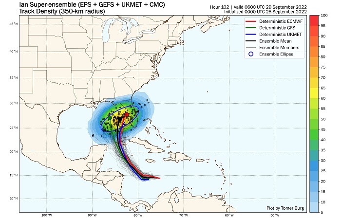
Tomer Burg's Super-ensemble has continued its shift west (left) with the most recent composite, 12Z. Will be very informative to see how the 0z coming up looks.
|
IsoFlame
Weather Analyst

Reged:
Posts: 295
Loc: One block off the Atlantic Oce...
|
|
Ian's rag-a-muffin lack of consolidation/strengthening today and ongoing shear widened the cone with two spaghetti plot camps: FL panhandle/Big Bend versus Tampa/Port Charlotte.
Lack of strengthening during daylight hours today due to ongoing shear and less than stellar organization should not let anyone in the cone let their guard down. Westward shift of forecast track = less (if any) significant interaction with western Cuba, and a delayed US landfall (by a day) = more time over seasonal max SST's in the NW Caribbean and eastern GOMEX. with increasingly favorable conditions next 48 hours,
At some point late tomorrow into Monday when rapid intensification is well underway, models should gorge on rich upstream data from extensive atmospheric parameter sampling, reaching much better consensus.
..
--------------------
CoCoRaHS Weather Observer (FL-VL-42) & Surf Forecaster: https://www.surf-station.com/north-florida-surf-forecast-3/
|
MikeC
Admin
Reged:
Posts: 4544
Loc: Orlando, FL
|
|
The model split continues overnight. , HWRF are in the panhandle west of Panama City Beach (near Seaside) -- 6z moved to Panama City Beach itself . is near Cedar Key. UKMET, Icon, and the Euro are now south of Tampa. (All shifted right some, although the icon shifted the most right).
The Current forecast splits the difference, and add onto that uncertainty about the center of Ian persists as it looks like the more northern area (under the convection) is starting to win out.
"With the cross-track spreading remaining between 200-220 n mi at days 4 and 5, it cannot be overstated that significant uncertainty remains in Ian's long-range prediction. "
This is the story for this morning. The entire cone still needs to take this seriously.
At least the MLC looks to be around 15.5N this morning, so I expect it to consolidate there, the south one seemed like a red herring. LLC may not be there yet, recon has that at 14.9N 79.4W, i expect it'll slide up to match the MLC fairly soon.
|
MichaelA
Weather Analyst

Reged:
Posts: 944
Loc: Pinellas Park, FL
|
|
Yes, the 00Z model runs took a slight eastward shift again. With more Gulfstream IV data becoming available and if Ian can get vertical and begin the predicted rapid intensification, I would assume the models would begin to converge. Time will tell, and no one in the cone should relax just yet.
--------------------
Michael
PWS
|
MikeC
Admin
Reged:
Posts: 4544
Loc: Orlando, FL
|
|
Model uncertainty this morning
Edited by cieldumort (Mon Sep 26 2022 05:23 PM)
|
MikeC
Admin
Reged:
Posts: 4544
Loc: Orlando, FL
|
|
Lounge thoughts is that the Consensus will settle closer to Cedar Key or Steinhatchee, but the Euro (even 6z now is south of Tampa) with a move north. So it looks like it could get uncomfortably close to Tampa, potentially slide along just offshore (with the dirty side over land) and eventually landfall in the Big Bend or at/around Cedar Key.
This would be pretty bad for surge if that happened from at least Tampa up, but hoping it stays far enough west to avoid the worst of that.
|
JMII
Weather Master

Reged:
Posts: 489
Loc: Margate, Florida
|
|
Not what I expected this AM in terms of organization - Ian’s a mess. Reading the discussion the lack of a true center is causing issues with determining strength and direction. Long term model guidance seems plagued by “when†leading to confusion over where. Slower motion favorites a N track while faster movement would allow the turn E into Tampa to occur. All models point to a ramp up into a major ‘cane but you wouldn’t know that by the current satellite imagery.
--------------------
South FL Native... experienced many tropical systems, put up the panels for:
David 79 - Floyd 87 - Andrew 92 - Georges 98 - Frances 04 - Wilma 05 - Matthew 16 - Irma 17
Lost our St James City rental property to Ian 22
|
IsoFlame
Weather Analyst
Reged:
Posts: 295
Loc: One block off the Atlantic Oce...
|
|
Quote:
Not what I expected this AM in terms of organization - Ian’s a mess. Reading the discussion the lack of a true center is causing issues with determining strength and direction. Long term model guidance seems plagued by “when†leading to confusion over where. Slower motion favorites a N track while faster movement would allow the turn E into Tampa to occur. All models point to a ramp up into a major ‘cane but you wouldn’t know that by the current satellite imagery.
I've had the same thoughts watching NINE and TS Ian to this point. However, at noon satellite imagery illustrates possible stacking of circulation and influx of banding deep convection NE of the center, leading me to believe that Ian's unimpressive organization so far is about to dramatically change this afternoon through the evening. Next 48-60 hours we could witness an exponential (Camille-like?) ramp-up in intensity to 140 mph as forecast and intensity models suggest.
Even though the cone shifted west away from Tampa Bay region today, I hope newcomers to the Bay area or those that did not have grandparents that lived there, are preparing for flooding rainfall and a near historic storm surge potentially approaching (OR EXCEEDING) 10 feet.
Even though it is a beautiful late September weekend and it may be hard to grasp how dramaticlly conditions may go downhill early Wednesday as Ian nears, PAY VERY CLOSE ATTENTION TO THE OFFICIAL FORECAST AND ALL UPCOMING WARNINGS when Ian's organization dramatically improves, allowing modeling to narrow down ultimate track/intensity and Florida west coast landfall.
--------------------
CoCoRaHS Weather Observer (FL-VL-42) & Surf Forecaster: https://www.surf-station.com/north-florida-surf-forecast-3/
Edited by IsoFlame (Sun Sep 25 2022 05:04 PM)
|
MikeC
Admin
Reged:
Posts: 4544
Loc: Orlando, FL
|
|
Ian's 12Z models all shifted east, including the euro which has increased the risk for the Florida peninsula tonight. However the system has failed to get organized much today, but still is primed to do so soon. It's moving NW now it looks like.
Even the TVCN consensus shifted right today, so 5PM update should have a decent shift 25-35 mile east.
|
MichaelA
Weather Analyst
Reged:
Posts: 944
Loc: Pinellas Park, FL
|
|
The 18Z has shifted eastward again indicating a close brush to Tampa Bay then continuing into the Big Bend. Currently waiting for the other 18Z model runs. Ian did not intensify today, but the consensus still calls for Cat 3 intensity near Cuba’s western tip on Monday. Southwesterly shear is expected to weaken the storm beginning Tuesday into Wednesday leading to a weakening but expanding storm. That could mean an extended time period of nasty weather along the entire west coast of Florida. Keep watching and making your storm preparations.
*Edit* The 18Z HMON nudged a bit East and the 18Z HWRF nudged a bit West. It’s still a crap shoot.
--------------------
Michael
PWS
Edited by MichaelA (Mon Sep 26 2022 01:12 AM)
|
Keith B
Weather Hobbyist
Reged:
Posts: 57
Loc: FL, Orange County
|
|
Admin,
Is it possible to have the viewing of information be screen width and not beyond, please?
I have attached my screen pic for reference.
Thank you.
--------------------
Keith Boyer N4TRN
Orange County ARES
Asst. Emerg. Coord. (AEC) Skywarn Orange County, FL
http://www.ocares.org/
|
MichaelA
Weather Analyst
Reged:
Posts: 944
Loc: Pinellas Park, FL
|
|
The 11 PM track guidance shifts slightly eastward again, bringing the center of Ian at Cat 2/3 to about 60 miles west of the mouth of Tampa Bay at 8 PM Wednesday. Model runs have been trending eastward all day today, and I expect that trend might continue in the short term. Be vigilant and make your preparations tomorrow and Tuesday.
--------------------
Michael
PWS
|
GeorgeN
Weather Watcher
Reged:
Posts: 33
Loc: Wesley Chapel FL
|
|
The 8AM is similar to last night, though the Euro appears to be shifting West to follow the . For some reason, the UKMET shows landfall around Venice, with exit around Jacksonville. I'm not sure why it departed from the other plots, but this is causing the track to skew East. I'm sure it's a bad plot, but I prefer to be on the good side, so I'm rooting for the UKMET.
--------------------
Wesley Chapel FL - since 1990
Previous resident of North Miami and Merritt Island
|
JMII
Weather Master
Reged:
Posts: 489
Loc: Margate, Florida
|
|
Ian is, as predicted, getting its act together. Outflow is good in all quadrants, the core is developing. The big change I see in the forecast is this slower motion (with more surge) and a shear inducted weakening in the end. Several forecasts ago we were looking at a curve across the state and out to sea over the east coast. Now it could just move into GA and die there.
The problem continues to be this follow-the-coast type track which puts a large area along the west coast to the panhandle in the danger zone. If the wind field expands the entire west coast of FL could experience hurricane force winds. In the end the size of the storm may be more of an issue then where exactly it makes landfall. A small but strong storm that stays just offshore then weakens before landfall is the best case situation. The model diversions start after moving N of Key West, so once it cross Cuba hopefully the models get a better grasp on things and we see a narrowing of possibilities. The approach angle means small difference in the track could make big differences in the future, or it may not matter since so much of the coast will be effected. On the flip side the core staying offshore just enough would only generate TS winds onshore.
--------------------
South FL Native... experienced many tropical systems, put up the panels for:
David 79 - Floyd 87 - Andrew 92 - Georges 98 - Frances 04 - Wilma 05 - Matthew 16 - Irma 17
Lost our St James City rental property to Ian 22
|
OrlandoDan
Weather Master

Reged:
Posts: 443
Loc: Longwood, FL
|
|
11 am adjusted the track slightly east again.
--------------------
Keith (1988), Charley (2004), Frances (2004) , Jeanne (2004), Fay (2008), Mathew (2016), Irma (2017), Dorian (2019)
Personal Weather Station: https://www.wunderground.com/dashboard/pws/KFLLONGW67
|
pongolo
Registered User
Reged:
Posts: 1
|
|
I'm pretty sure the issue is the image in post #114244 since it's very wide and it makes all posts be much wider than typical.
|


 Threaded


