Psyber
Storm Tracker

Reged:
Posts: 231
Loc: Ontario, Canada
|
|
Quote:
Quote:
It wasn't supposed to be a hurricane before Cuba in a lot of forecasts two days ago, and now we have an intensifying H2 that doesn't even have a visual eyewall.
Please see the attached graphic from 11pm Saturday clearly forecasting a MAJOR prior to Cuba.
It did say, Major, for almost an entire day, and yet it's not, now is it? I suppose it could have time, but all the people pointing at wind shear are demanding it should slow down. It's not and that's my point. It's also not following the CHC and that was my point too. It's not following a whole lot of forecasts and that's my point too.
Look, my point is that people are able to look at a storm one day in advance and then be fifty percent slower than the forecast? RAW data doesn't work. This is including airplane data, buoy data, information from islands and, ships and satellites and here we are with a storm that barely stepped into an H2 that was supposed to be H3 or higher all day. Certainly, wind shear has affected it, but the original person I replied to seemed to be talking like Cuba was going to wreck the storm "like it always does". This isn't an East-to-West Cuba storm, so I was only saying that Cuba isn't really going to affect this one.
We went on a bit of a trip however, I've said my part (including an apology to do with confusing the current wind shear or the one over Florida later in the week. That's it, that's all, please disperse, there is nothing to see here.
--------------------
The safest way to deal with a potential Hurricane hitting you...is to leave and just not be there at all.
|
Psyber
Storm Tracker
Reged:
Posts: 231
Loc: Ontario, Canada
|
|
Quote:
Does anyone know why the model has been pulled far off it's Mean value into this new and sudden plot departure? The UKMET has been predicting a more Southern FL landfall all along, but it's concerning to see the pulled from it's previous course like this. Is there something in the UKMET that wasn't factored in, or just bad statistical analysis on the last run? Mean is still showing a panhandle landfall, at least the 1200 UTC shows it. I'm trying to figure out why the has the sudden East, North, West, then East jog. It's like the storm is avoiding a deer in the road. The more I learn, the more I don't understand.
If it's the same problem, I saw other 22:30UTC products that were broken/hadn't plotted.
--------------------
The safest way to deal with a potential Hurricane hitting you...is to leave and just not be there at all.
|
Robert
Weather Analyst

Reged:
Posts: 364
Loc: Southeast, FL
|
|
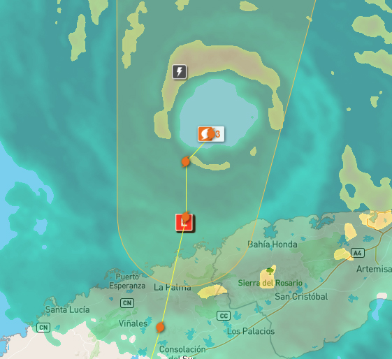
Here is a link for good radar from isle haveturad or what ever... www.insmet.cu/asp/genesis.asp?TB0=PLANTILLAS&TB1=RADAR&TB2=../Radar/02IJuventud/pdeMAXw01a.gif
Looks like it's moving close to north now..
Edited by Robert (Tue Sep 27 2022 12:12 AM)
|
Psyber
Storm Tracker
Reged:
Posts: 231
Loc: Ontario, Canada
|
|
Quote:
Here is a link for good radar from isle haveturad or what ever... www.insmet.cu/asp/genesis.asp?TB0=PLANTILLAS&TB1=RADAR&TB2=../Radar/02IJuventud/pdeMAXw01a.gif
Looks like it's moving close to north now..
Check the link!
Ruh Roh!
Edited by Psyber (Tue Sep 27 2022 12:33 AM)
|
MikeC
Admin
Reged:
Posts: 4544
Loc: Orlando, FL
|
|
18Z euro is south of tampa and goes right over orlando, similar to the UKmet. rides the coast near tampa. This is the current dangerous split Both are bad news.
|
Lautermilch
Registered User
Reged:
Posts: 9
|
|
Video about what could happen if a storm hits Tampa
https://youtu.be/2U8Huqbxxus
|
Psyber
Storm Tracker
Reged:
Posts: 231
Loc: Ontario, Canada
|
|
Quote:
Video about what could happen if a storm hits Tampa
https://youtu.be/2U8Huqbxxus
The chances of this being an H4-H5 while always being possible because everything is, are VER VER VERY slim. A whole trough of high level air is coming to severely lessen Ian.
Please make sure you tell your friends and family that the chance of that happening is like maybe...0.5%. Panic can be just as dangerous as the truth.
I should add that it's NEVER a bad idea to get out of the projected path of a storm. Go to a Motel 8 somewhere out of Florida and over to Alabama. (Unless the map gets Donald Trumped with a sharpie).
All kidding aside, like I said, never a bad idea to go north and west to get away from this storm. Motel 8 with some free Wifi, eat Chic-fil-a for a couple days and there is no risk from the storm.
--------------------
The safest way to deal with a potential Hurricane hitting you...is to leave and just not be there at all.
Edited by Psyber (Tue Sep 27 2022 01:52 AM)
|
cieldumort
Moderator

Reged:
Posts: 2305
Loc: Austin, Tx
|
|
There's a lot of push and pull going on with Ian that still makes US landfall location and by extension landfall intensity very difficult for being just 1-3 days out.
The 0z runs have already made some errors in one place, while gotten things right in another, in some ways cancelling each pro and con out that could result in the same landfall location and intensity had both been correct. Could. Or not. It is easy to see how it could, and could not. This doesn't make the track forecast any less muddy.
Given Ian's near Cat 4 intensity heading into western Cuba, a track to the right sooner rather than later makes sense, considering the deeper trof digging into the eastern US. A hook right sooner rather than later could also protect Ian from the incoming shear over the region, at least in the near to medium term, allowing the cyclone to maintain a stronger intensity than should it track more north-bound, and headlong into the incoming shear.
Locations from roughly Tampa south may want to pay close attention to any subtle changes in Ian's track today, as they could add up in time to a more south-bound ultimate landfall.
|
MichaelA
Weather Analyst

Reged:
Posts: 944
Loc: Pinellas Park, FL
|
|
Looking at the satellite loops this morning, it appears that the has begun to expand, indicating that Ian has begun to expand. The projected path does appear to be one that would lessen the storm surge impact to Tampa Bay. However, a slight wobble one way or the other will cause major changes to the local impacts. Also, Ian is projected to slow significantly as it approaches landfall which will result in extended exposure to damaging winds and rainfall. At any rate, everyone should have their preparations completed and keep abreast of each update.
--------------------
Michael
PWS
|
JMII
Weather Master

Reged:
Posts: 489
Loc: Margate, Florida
|
|
Ian is about to come off the coast of Cuba. Now that we can see the eye on both satellite and Key West radar tracking small changes / wobbles will become easier. The models (and ) have shifted the track a bit more E and a direct hit into Tampa Bay or slightly south as a Cat 3 is becoming more and more likely. Weds AM TS force winds will arrive in the area leaving 24 hours to prepare. Thurs to Fri as Ian moves inland it doesn't go very far so this is going to be a prolonged event. Recon flights will provide the details on the wind field. The only good news is the follow-the-coast track may not materialize if Ian stays on track, instead we'll see a slow bend / curve off the Cuban coast and into W FL.
--------------------
South FL Native... experienced many tropical systems, put up the panels for:
David 79 - Floyd 87 - Andrew 92 - Georges 98 - Frances 04 - Wilma 05 - Matthew 16 - Irma 17
Lost our St James City rental property to Ian 22
|
IsoFlame
Weather Analyst

Reged:
Posts: 295
Loc: One block off the Atlantic Oce...
|
|
Quote:
The only good news is the follow-the-coast track may not materialize if Ian stays on track, instead we'll see a slow bend / curve off the Cuban coast and into W FL.
Good news for Florida west coast Tampa Bay northward. Bad news for west coast near and south of landfall.
Potentially, bad news for Daytona/Flagler Beach, St. Augustine and Jacksonville. This morning's model guidance suggests Ian's center will cross peninsula with eye even re-emerging fully over the very warm near shore Atlantic north of the Cape, maintaining strong tropical storm force (even regaining Cat 1?) over coastal waters up to the Golden Isles of Georgia.
Based on this possibility, I'm anticipating a slower, wetter and weaker version of for inland central/east central Florida.
--------------------
CoCoRaHS Weather Observer (FL-VL-42) & Surf Forecaster: https://www.surf-station.com/north-florida-surf-forecast-3/
|
JMII
Weather Master
Reged:
Posts: 489
Loc: Margate, Florida
|
|
Based on radar its currently tracking on the eastern edge of the cone. Could be looking at another -like event were the focus was on Tampa but the storm comes in further south. Still early... and thus begins the classic" it is a wobble or a trend hour-by-hour play out.
|
RevUp
Weather Guru
Reged:
Posts: 181
Loc:
|
|
Thinking the same thing about (2004). My family evac'd Upper Tampa Bay back then and ended up in Orlando with CAT 1 damage. Pretty consistent model trend of a slightly more eastward track.
--------------------
"Let tomorrow worry about itself. Each day has enough trouble of its own."
|
GeorgeN
Weather Watcher

Reged:
Posts: 33
Loc: Wesley Chapel FL
|
|
As the Euro and track South, I'm still trying to figure out how the UKMET calculated this track all the way back to Sunday. While the other plots were skipping around, UKMET was glued to this area. I know the is better for open ocean runs as it doesn't account for land interaction as well. The Euro did forecast the same landfall as UKMET on Sunday, then it started to track North until it snapped back. I need to do some more research on the UKMET model.
Tampa and the West coast still need to prepare. Irma ran up the state then jogged back towards Tampa in 2017. The eye was 10 miles from my house and it shredded a lot of trees.
--------------------
Wesley Chapel FL - since 1990
Previous resident of North Miami and Merritt Island
|
IsoFlame
Weather Analyst
Reged:
Posts: 295
Loc: One block off the Atlantic Oce...
|
|
Even though weaker @ 11 AM advisory, eye looks smaller and is starting to clear out with "stadium effect" becoming visible on west eye wall:
Ian visible floater
--------------------
CoCoRaHS Weather Observer (FL-VL-42) & Surf Forecaster: https://www.surf-station.com/north-florida-surf-forecast-3/
|
IsoFlame
Weather Analyst
Reged:
Posts: 295
Loc: One block off the Atlantic Oce...
|
|
Brian Norcross @ noon: " Wobbles when Ian landfalls will make all the difference regarding greatest impact along Florida's west coast."
--------------------
CoCoRaHS Weather Observer (FL-VL-42) & Surf Forecaster: https://www.surf-station.com/north-florida-surf-forecast-3/
|
JMII
Weather Master
Reged:
Posts: 489
Loc: Margate, Florida
|
|
The just issued a position correction, it appears they noticed its E of the forecast track.
|
Psyber
Storm Tracker
Reged:
Posts: 231
Loc: Ontario, Canada
|
|
Quote:
Based on radar its currently tracking on the eastern edge of the cone. Could be looking at another -like event were the focus was on Tampa but the storm comes in further south. Still early... and thus begins the classic" it is a wobble or a trend hour-by-hour play out.
Sorry but I hate to say I'm right when I'm right, but it needs to be said that I was right about how little Cuba was going to touch this storm. In fact, it sped up for a little bit because it was always going to have a huge chunk of the upper left of the storm over water.
I only bring this up because I feel very...sensitive about how the third-world people from Puerto Rico (yes, I consider them 3rd world because the rest of the USA seems to treat them as such (note>I'm from Canada and can sense the...distaste all the way up here) and Cuba and the Dominican and any other country that basically act like hurricane breaks or half of these beasts would enter the Gulf at H3 or H4's before turning into H5's. Watching these unfortunate places get smashed time after time and entirely too many people don't really care about a storm until it's tracking for a continental USA hit is an understatement.
If you asked pretty much everybody about how many Cubans were killed from H3=Ian, the answer from damn near all of them would be..."errrrr, I don't know. It's really going to smoke Florida, though!"
People sit and hum and haw and wonder what's going to happen to a storm because outside of wind sheer/other wind messing with a storm, I can look at the wind and how hot the water is and TELL you what's going to happen to a storm because I've been doing it for 17 years now.. Personally, on large storms that stay over hot water, I'm over 80% right on a destination, give or take 50km from 3 days out. I maintain this level of success because when you drill it all down, a storm is all about water and wind. That's it.
Bands of storms get pulled out of the ocean from hot SST's and wind, and storms get knocked down from cool SST's and wind. The storms I'm wrong on are those that make their own weather despite conditions. The super large, big enough to be ripping storms out of the entire Gulf all at once kind of storms or smaller storms that wobble all over the place.
Note>I don't mean to sound cocky; I just point to the fact that I think people make forecasting storms entirely too complex. The Storm Hunters are now giving data on all four quadrants of a storm that people pour over and feed into models to see what they say when they can just look at the wind and the water, follow a strong model and then add some intelligence to what they SEE. Nobody seems to just LOOK anymore. As far as I'm concerned, every model is going to be wrong because every storm is different and completely archaic.
Certainly, I recommend that people use some modelling, but people need to go back to using their eyes and some common sense too.
In my opinion, which of course is going to get attacked, but hey, I'll trust my 80% forever.
--------------------
The safest way to deal with a potential Hurricane hitting you...is to leave and just not be there at all.
|
Psyber
Storm Tracker
Reged:
Posts: 231
Loc: Ontario, Canada
|
|
Quote:
The just issued a position correction, it appears they noticed its E of the forecast track.
At least we have an eye and some damn stability now, though!
--------------------
The safest way to deal with a potential Hurricane hitting you...is to leave and just not be there at all.
|
MichaelA
Weather Analyst
Reged:
Posts: 944
Loc: Pinellas Park, FL
|
|
The latest satellite loops seem to show that Ian is following a NNE course. By extrapolation, that would put landfall in the Cape Coral area. We’ll see what the 5PM advisory package does with it.
--------------------
Michael
PWS
|


 Threaded


