cieldumort
Moderator

Reged:
Posts: 2305
Loc: Austin, Tx
|
|
3:30PM EDT Update 28 September 2022 Update
Ian made landfall around 3:05PM EDT along the southwestern coast of Florida near Cayo Costa with maximum sustained winds near 150 mph and minimum central pressure estimated from reconnaissance data at 940mb.
For most locations, despite gradual 'weakening' from here, the worst is actually yet to come.
7:00AM EDT Update 28 September 2022 Update
Ian is effectually now a large Category 5 hurricane heading into landfall. Special advisory products from :Quote:
Hurricane Ian Special Advisory Number 23
NWS National Hurricane Center Miami FL AL092022
700 AM EDT Wed Sep 28 2022
...RAPIDLY INTENSIFYING IAN FORECAST TO CAUSE CATASTROPHIC STORM SURGE, WINDS, AND FLOODING IN THE FLORIDA PENINSULA...
SUMMARY OF 700 AM EDT...1100 UTC...INFORMATION
----------------------------------------------
LOCATION...25.9N 82.8W
ABOUT 65 MI...100 KM WSW OF NAPLES FLORIDA
ABOUT 80 MI...130 KM SSW OF PUNTA GORDA FLORIDA
MAXIMUM SUSTAINED WINDS...155 MPH...250 KM/H
PRESENT MOVEMENT...NNE OR 15 DEGREES AT 9 MPH...15 KM/H
MINIMUM CENTRAL PRESSURE...937 MB...27.67 INCHES
WATCHES AND WARNINGS
--------------------
CHANGES WITH THIS ADVISORY:
None
SUMMARY OF WATCHES AND WARNINGS IN EFFECT:
A Hurricane Warning is in effect for...
* Chokoloskee to Anclote River, including Tampa Bay
* Dry Tortugas
A Storm Surge Warning is in effect for...
* Suwannee River southward to Flamingo
* Tampa Bay
* Lower Florida Keys from Big Pine Key westward to Key West
* Dry Tortugas
* Flagler/Volusia Line to the mouth of the St. Mary's River
* St. Johns River
A Tropical Storm Warning is in effect for...
* Cuban provinces of La Habana, Mayabeque, and Matanzas
* Indian Pass to the Anclote River
* All of the Florida Keys
* Flamingo to South Santee River
* Flamingo to Chokoloskee
* Lake Okeechobee
* Florida Bay
* Bimini and Grand Bahama Islands
A Storm Surge Watch is in effect for...
* Florida Keys from the Card Sound Bridge westward to east of Big
Pine Key
* Florida Bay
* Mouth of St. Mary's River to South Santee River
A Storm Surge Warning means there is a danger of life-threatening
inundation, from rising water moving inland from the coastline, in
the indicated locations. For a depiction of areas at risk, please
see the National Weather Service Storm Surge Watch/Warning Graphic,
available at hurricanes.gov. This is a life-threatening situation.
Persons located within these areas should take all necessary actions
to protect life and property from rising water and the potential for
other dangerous conditions. Promptly follow evacuation and other
instructions from local officials.
A Hurricane Warning means that hurricane conditions are expected
somewhere within the warning area. Preparations to protect life and
property should be rushed to completion.
A Tropical Storm Warning means that tropical storm conditions are
expected somewhere within the warning area.
A Storm Surge Watch means there is a possibility of life-
threatening inundation, from rising water moving inland from the
coastline, in the indicated locations during the next 48 hours.
For storm information specific to your area, please monitor
products issued by your national meteorological service.
DISCUSSION AND OUTLOOK
----------------------
At 700 AM EDT (1100 UTC), the eye of Hurricane Ian was located by
Air Force and NOAA Hurricane Hunter data near latitude 25.9 North,
longitude 82.8 West. Ian is moving toward the north-northeast near
9 mph (15 km/h). This general motion with a reduction in forward
speed is forecast today, followed by a turn toward the north on
Thursday. On the forecast track, the center of Ian is expected to
approach the west coast of Florida within the hurricane warning
area this morning, and move onshore later today. The center of Ian
is forecast to move over central Florida tonight and Thursday
morning and emerge over the western Atlantic by late Thursday.
Maximum sustained winds have increased to near 155 mph (250 km/h)
with higher gusts. Ian is a category 4 hurricane on the
Saffir-Simpson Hurricane Wind Scale. Ian is forecast to make
landfall on the west coast of Florida as a catastrophic category 4
hurricane. Weakening is expected after landfall.
Hurricane-force winds extend outward up to 40 miles (65 km) from the
center and tropical-storm-force winds extend outward up to 175 miles
(280 km).
The minimum central pressure is 937 mb (27.67 inches) based on Air
Force Hurricane Hunter dropsonde data.
HAZARDS AFFECTING LAND
----------------------
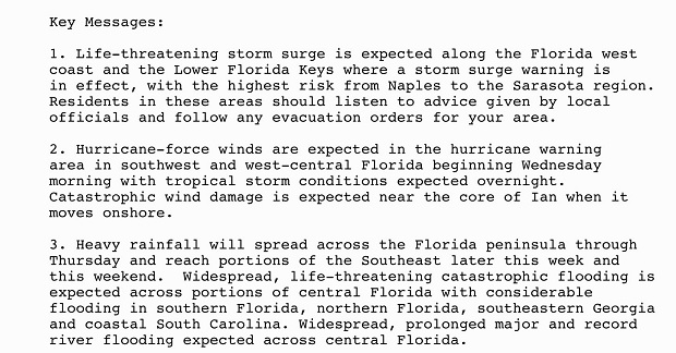
Key messages for Ian can be found in the Tropical Cyclone Discussion
under AWIPS header MIATCDAT4 and WMO header WTNT44 KNHC and on the
web at hurricanes.gov/text/MIATCDAT4.shtml.
STORM SURGE: The combination of storm surge and the tide will cause
normally dry areas near the coast to be flooded by rising waters
moving inland from the shoreline. The water could reach the
following heights above ground somewhere in the indicated areas if
the peak surge occurs at the time of high tide...
* Englewood to Bonita Beach, including Charlotte Harbor...12-16 ft
* Middle of Longboat Key to Englewood... 6-10 ft
* Bonita Beach to Chokoloskee...7-11 ft
* Anclote River to Middle of Longboat Key, including Tampa Bay...4-6
ft
* Chokoloskee to East Cape Sable...4-7 ft
* Suwannee River to Anclote River...3-5 ft
* Lower Keys from Key West to Big Pine Key, including the
Dry Tortugas...3-5 ft
* Flagler/Volusia County Line to Savannah River including St. Johns
River...3-5 ft
* St. Johns River south of Julington...2-4 ft
* Savannah River to South Santee River...2-4 ft
* East Cape Sable to Card Sound Bridge...2-4 ft
* Florida Keys east of Big Pine Key...2-4 ft
* Patrick Air Force Base to Flagler/Volusia County Line...1-3 ft
* Indian Pass to Suwanee River...1-3 ft
The deepest water will occur along the immediate coast near and to
the right of the center, where the surge will be accompanied by
large waves. Surge-related flooding depends on the relative timing
of the surge and the tidal cycle, and can vary greatly over short
distances. For information specific to your area, please see
products issued by your local National Weather Service forecast
office.
WIND: Catastrophic wind damage is likely where the core of Ian
moves onshore. Hurricane conditions will begin along the west
coast of Florida within the Hurricane Warning area later this
morning, with tropical storm conditions beginning before daybreak.
Tropical storm conditions are occurring in the warning area in the
Florida Keys, and will continue this morning. Tropical storm
conditions are expected in the warning area on the east coast of
Florida beginning today, and should spread up the Georgia and
South Carolina coasts tonight and Thursday. Tropical storm
conditions are expected within the warning area in Cuba for the
next few hours.
RAINFALL: Ian is expected to produce the following storm total
rainfall:
* Florida Keys and South Florida: 6 to 8 inches, with local maxima
up to 12 inches.
* Central and Northeast Florida: 12 to 18 inches, with local
maxima up to 24 inches.
* Eastern Georgia and Coastal South Carolina: 4 to 8 inches, with
local maxima of 12 inches.
Widespread, life-threatening catastrophic flash, urban, and river
flooding is expected across central Florida. Widespread
considerable flash, urban, and river flooding is expected across
portions of southern Florida through Wednesday, and northeast
Florida, southeastern Georgia, and coastal South Carolina later this
week through the weekend. Limited flash, urban, and river flooding
is possible over portions of the Southeast and southern Mid-Atlantic
later this week through the weekend.
TORNADOES: Tornadoes are possible today and tonight across central
and south Florida.
SURF: Swells generated by Ian are affecting the northern coast
of Cuba, the northeastern coast of the Yucatan peninsula and
west coast of Florida. These swells will spread westward along
portions of the north-central Gulf coast during the next day or so.
Swells will increase along the east coast of Florida, Georgia, and
South Carolina tonight and Thursday. These swells are likely to
cause life-threatening surf and rip current conditions. Please
consult products from your local weather office.
NEXT ADVISORY
-------------
Next intermediate advisory at 800 AM EDT.
Next complete advisory at 1100 AM EDT.
6:30AM EDT Update 28 September 2022 Update
Original Entry
Major Hurricane Ian continues to reintensify overnight and unfortunately after an earlier Eyewall Replacement Cycle, is also larger. Ian may become a Cat 5 prior to landfall, but would still be incredibly dangerous and catastrophic, regardless.
Models are clustering better this morning just hours out from initial landfall, but a little wobble here or there could mean the absolutely catastrophic impacts affect you, while "just" horribly dangerous conditions hit a few miles away. Those in Ian's path and in particular in any evacuation zones should be rushing efforts to protect life and property to completion. Lives will likely be lost, and possibly many. Don't let it be your own or those you love.
A secondary set of impacts well inland from very high rainfall totals looks likely, as well as storm surge on the east coast. Then, a second landfall is now looking more likely than not, somewhere around GA/SC Friday.
Ian is a deadly serious storm. This can not be overstated. The hurricane is in the same class as those infamous cyclones that no one wants to remember.
For in-depth model analysis and a place for more speculative discussions, join us in the Ian Forecast Lounge
Florida Emergency Management
News Media (South Florida):
Television:
Newspapers:
News Radio:
Check local media and officials when a storm is approaching your area.
News Media (East Central Florida):
Television:
Newspapers:
News Radio:
Check local media and officials when a storm is approaching your area.
Edited by cieldumort (Wed Sep 28 2022 07:41 PM)
|
cieldumort
Moderator
Reged:
Posts: 2305
Loc: Austin, Tx
|
|
|
|


 Threaded


