MikeC
Admin
Reged:
Posts: 4870
Loc: Orlando, FL
|
|
This area is now developed by the Euro (keeps it offshore), 0z (Gulf into Florida Panhandle on Tue Aug 6), and now 12Z Icon (Run ends in the Gulf) it's time for it's own lounge, even though it'll unlikely be an invest area until probably midweek, since it's likely to be a late bloomer.
This wave has been Invest tagged 97L on the morning of Aug 1 and the title has been updated accordingly.
PTC FOUR 11AM Aug 2.
Ciel
|
MikeC
Admin
Reged:
Posts: 4870
Loc: Orlando, FL
|
|
12z has a slow moving system int he Gulf on Tuesday August 6, makes landfall near Panama City Beach
12z has a cat 1 hurricane approaching Apalachicola Monday morning
Euro and UKMet don't show Gulf, the12z UK has a system forming near Nassau in the Bahamas and the 0z euro moved it offshore before the Bahamas.
|
cieldumort
Moderator

Reged:
Posts: 2934
Loc: Austin, Tx
|
|
Models today are definitely more excited about its potential. Given the large size of the dry tropical wave and abundant islands along its current forecast trajectory, very slow to at best modest organization and strengthening throughout most if not all of its track seems the most probable outcome. Perhaps eventually a hurricane if everything comes together just right. Current odds of 40% for TC genesis within 7 days looks reasonable, which is also 60% odds of no genesis. Will be interesting to see how it is or isn't coming together by mid-week.
|
bob3d
Weather Hobbyist

Reged:
Posts: 65
Loc: Pasco County, Florida
|
|
MikeC: What are the , , Euro, and UKMet models showing today?
|
cieldumort
Moderator
Reged:
Posts: 2934
Loc: Austin, Tx
|
|
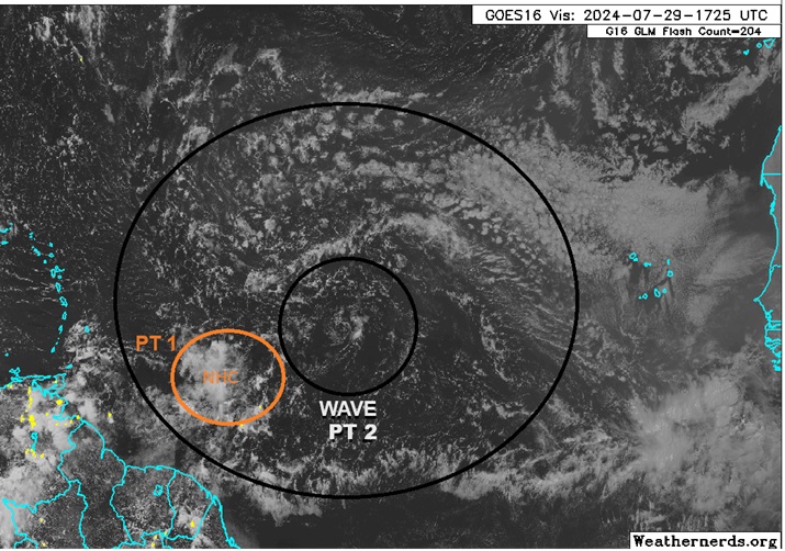
Here is a current view of our two part Area of Interest. has most everyone focused on the area of disturbed weather with some gentle elongated rotation I have labeled PT 1. However, the more significant player is likely to be the tropical wave and its large gyre I have labeled here as PT 2.
Both the gyre and its embedded well-defined LLC are presently void of any thunderstorms, as is the area of disturbed weather to its southwest (PT 1). With echos of 2013, the Atlantic has been struggling throughout the month of July to produce anything given the exceptionally large plumes of SAL coming off Africa, along with an unfavorable state. As we enter August this begins to turn less unfavorable, with a reduction in the amount of dry, dusty Saharan air forecast to coincide with at least a somewhat more favorable background state.
Big picture, gradual organization of the two combined features, probably ultimately focusing more within the gyre (PT 2), does seem possible.
Operational model runs have really backed off today, and 50% development odds within 7 days may be about right.
The risk of either feature or their combo becoming a strong tropical storm or hurricane is of course better if the system/s overall stay/s south or north of the largest and tallest islands. Significant development north of those islands could favor a track more towards the Carolinas, and/or even out to sea. Significant development south of those islands might favor central America to Mexico. Modest development might favor Florida and/or Gulf Coast states.
|
MikeC
Admin
Reged:
Posts: 4870
Loc: Orlando, FL
|
|
Still a 50% chance for development, the wave has the two sections, but the eastern one will likely become dominant, the models this afternoon have been showing a stalling system either over the Gulf or South Carolina in the 12Z euro. All weak, there are a few ensembles with stronger members however. The UKMet also shows a weak South Florida landfall. Anything south of the islands into Mexico is extremely unlikely, but out to sea is still possible. The SAL is likely to be much less a factor in a few weeks.
Most likely a rainmaker for somewhere, Bahamas, or Southeast. Strong system is unlikely though. 2024 is not 2013, either, since SAL looks to be dropping off on schedule.
|
cieldumort
Moderator
Reged:
Posts: 2934
Loc: Austin, Tx
|
|
Further along in the 7 day outlook now, and the case for development is looking more compelling.
Models overall continue to favor the large wave becoming the dominant player here, leaving whatever portion of the southwestern area of disturbed weather that it doesn't devour too weak to amount to anything, with that feature's remains heading westward while south of the Greater Antilles.
With SAL coming back down from record high levels (see image below), along with continued moistening of the low levels, breaking the cap eventually becomes likely in a forecast low shear environment atop record warm SSTs, and the 30/0z runs have strongly flipped back to development. Of interest, there is now a greater spread in potential track for even a stronger TS or hurricane, with the operational delaying tropical cyclogenesis until this is in the NE GOM around August 6 and then sending a robust TC west towards a roughly Houston, TX landfall August 9.
This far out and with a system that isn't even Invest tagged, pure lounge speculation for landfall location/s and intensities, but it seems more likely than not that will be impacted, either directly or indirectly.
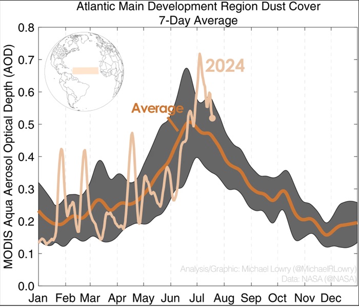
Above: Atlantic MDR dust coverage 7-day average credit: Michael Lowry
|
MikeC
Admin
Reged:
Posts: 4870
Loc: Orlando, FL
|
|
Overnight models are split, from the 0z Icon and staying offshore of Florida and east of the US (Barley),
The 0z Euro does move it into South Florida a s a weak system (wave/depression on Sunday, spins then heads out through Flagler Beach) then stalls a bit offshore of Myrtle Beach, SC.
The 6z , though, is still farther west, gets blocked and then moves in the Gulf (nearly touching Louisana0 but eventually landfalling near Corpus Christi, TX as a cat 2 hurricane on Friday August 9th. The 0z ruin was similar too, but more like a Cat 3 to Bolivar TX.
The UKMet itself now also takes the system into the Gulf over the Keys on Saturday as a weak storm/depression, then rides offshore along the west coast of Florida until the run ends before another landfall.
So one theme between the major models is the system gets blocked, Euro is further east so it gets blocked some over florida then stalls near the SC/NC Border, the gets further west and just gets blocked and shoved west all the way across the Gulf. Considering none of the models really develop anything until this weekend, speculation is really high now. So it's important to keep monitoring from the Caribbean islands, Bahamas, and SE And Gulf coasts.'
Add to the above, that most of the Euro Ensembles still keep it east and offshore of Florida, though, but some go into the Carolinas or slow down offshore, which is likely why the 8am outlook shows what it shows..
Middle of the model road is probably a large rain event for parts of FL/GC/SC. Stronger near term implies more of a right turn, less organize gives it a chance to move further west into Florida or Gulf, if it stays further south, /UK more likely.
Edited by CFHC (Tue Jul 30 2024 10:22 AM)
|
CFHC

Reged:
Posts: 217
Loc: East Central Florida
|
|
12z models (except Euro that isn't fully out yet) showing similar to 0z, just weaker in general (Especially ). Ukmet shows west ride still.
This still seems most likely just a big rain event for Florida and the Bahamas.
|
MikeC
Admin
Reged:
Posts: 4870
Loc: Orlando, FL
|
|
18z models aren't a big change, except for the 18Z (which is a big outlier, even to its ensembles) which shows a cat 3/4 hurricane approaching Louisiana on the morning of Saturday August 10th. The Icon is still east of florida, as is most of the euro ensembles, so that's still the most likely scenario, weak and bringing rain to Florida this Sunday.
|
IsoFlame
Weather Analyst

Reged:
Posts: 418
Loc: One block off the Atlantic Oce...
|
|
Quote:
12z models (except Euro that isn't fully out yet) showing similar to 0z, just weaker in general (Especially ). Ukmet shows west ride still.
This still seems most likely just a big rain event for Florida and the Bahamas.
That would be very welcome here on the central Volusia Atlantic coast as it has not rained the last 9 days and wet season rainfall is 7 inches (around 50%) below normal.
--------------------
CoCoRaHS Weather Observer (FL-VL-42) & Surf Forecaster: https://www.surf-station.com/north-florida-surf-forecast-3/
|
IsoFlame
Weather Analyst
Reged:
Posts: 418
Loc: One block off the Atlantic Oce...
|
|
Quote:
18z models aren't a big change, except for the 18Z (which is a big outlier, even to its ensembles) which shows a cat 3/4 hurricane approaching Louisiana on the morning of Saturday August 10th. The Icon is still east of florida, as is most of the euro ensembles, so that's still the most likely scenario, weak and bringing rain to Florida this Sunday.
Based on latest satellite illustrating the wave's steady 15-20 kt westward motion in the moderately strong easterly trades on the underbelly of the mid-Atlantic high, I think the western extension of the ridge will be strong enough to keep a weaker system below 25N as it nears the Florida peninsula. While the outlier may be correct on the track, I can't (at this time) buy into the latest call for a strengthening slow moving TS over the northeastern Gulf becoming a fairly strong hurricane impacting the northern Gulf coast somewhere between NOLA and P-COLA.
--------------------
CoCoRaHS Weather Observer (FL-VL-42) & Surf Forecaster: https://www.surf-station.com/north-florida-surf-forecast-3/
Edited by IsoFlame (Wed Jul 31 2024 07:48 AM)
|
CFHC
Reged:
Posts: 217
Loc: East Central Florida
|
|
12z models are a switchup, now 12Z and Euro show it moving into the Gulf, and stalling out near Florida on the Gulf Side near the big bend for 3-4 days of heavy rain across the peninsula.
Icon is similar but doesn't stall, does it, but stalls over Southeast Georgia.
Ensembles have shifted into over Florida into the Gulf now.
GFS shows 15+ inches of rain for parts of the Big Bend area, and 4+ inches of rain for central and North Florida + Pandhandle next week based on this.
Rain will be the big impact.
Euro rain estimates are pretty high (GFS even higher):

https://www.pivotalweather.com/model.php...mp;m=ecmwf_full
|
JMII
Weather Master

Reged:
Posts: 552
Loc: Cape Coral, FL
|
|
Quote:
Rain will be the big impact.
Interesting given how this area has been surround by dry air since it was first identified.
--------------------
South FL Native... experienced many tropical systems, put up the panels for:
David 79 - Floyd 87 - Andrew 92 - Georges 98 - Frances 04 - Wilma 05 - Matthew 16 - Irma 17
Lost our St James City rental property to Ian 22
|
CFHC
Reged:
Posts: 217
Loc: East Central Florida
|
|
Yep, two days ago there was nowhere near this much convection/moisture

It's going to gain more as it moves west, and that dry area to the west and north is already shrinking.
|
MikeC
Admin
Reged:
Posts: 4870
Loc: Orlando, FL
|
|
18z is slightly left of 12Z, and quite a bit stronger than 12Z, it gets to cat 1 hurricane strength in the Gulf Monday and makes landfall near Mexico Beach then meanders around toward St. Marks then back out into the gulf, restrengthens a bit then eventually another landfall closer to Destin, and the moves out of the area well inland later Thursday. Again massive Rainfall for a large part of Florida and Southern Georgia
|
MikeC
Admin
Reged:
Posts: 4870
Loc: Orlando, FL
|
|
18z Ensembles show the "Col" Steering collapse and meandering lines pretty well, which manifests in "drunken lines' on the chart below as the system just stalls out in various places. If it stalls out over land, tons of rainfall. If it stalls out over the Gulf, chance to strengthen a lot, AND dump tons of rainfall. Anywhere in the Gulf, Florida, and Southeast will need to keep an eye on this because it won't really develop until the weekend, and by then it'll already be raining in many of the areas.

|
MikeC
Admin
Reged:
Posts: 4870
Loc: Orlando, FL
|
|
0z is wild with a near landfall in Mexico Beach, FL on Monday as a hurricane, near because it pulls back south and out and meanders until Thursday and eventually makes landfall as a cat 3 around Bay St. Louis, MS.

0z UKMet goes into MS also, weaker though.
.
0z landfalls in the panhandle as a strong TS/cat 1 Hurricane
|
cieldumort
Moderator
Reged:
Posts: 2934
Loc: Austin, Tx
|
|
Would be easy to see this Invest tagged today.
The robust tropical wave is already producing numerous strong showers and thunderstorms, and while the largest and tallest islands are along its track ahead, modeling keeps trending towards the , which had been an outlier, favoring a future in the northeastern Gulf of Mexico. This would be one of the scenarios that would most favor the opportunity for a hurricane to form, and potentially a Major as shown in the very bullish run above, provided potential future Debby gets enough time over the Gulf waters.
I'd very much like to see recon begin flying the environment within and ahead of the wave to help models get a better handle on this. It is concerning that the once outlier seems to be leading the pack.
2AM odds of tropical cyclogenesis are 10% within 48 hours and still only 60% within 7 days. This may prove conservative on the 7 days (now more into the 5 day range), and justifiably, PTC watches and warnings could be issued over the weekend without a formed system.
|
MichaelA
Weather Analyst

Reged:
Posts: 956
Loc: Pinellas Park, FL
|
|
Things are indeed getting to be a bit dicey with the forecasting on this system. Conditions in the eastern Gulf are conducive to rapid development should a storm actually form. We still won’t have a good model handle until a definite center does form. It does appear to be a potential heavy rain event for much of Florida, storm formation or not. I’m preparing for the possibility of rapidly changing conditions over the next week.
--------------------
Michael
PWS
|


 Previous
 Index
 Next
 Threaded


 Edit
 Reply
 Quote


