MikeC
Admin
Reged:
Posts: 4870
Loc: Orlando, FL
|
|
This is for the new potential long track system exiting the African coast right now. If it develops, which it could do soon (according to the ) or later in the week (Euro) would likely be the candidate for the name Erin. 1995's Erin was the first hurricane covered by flhurricane (before it was flhurricane).
The lounge topics are to lightly discuss storms, speculation, gut feelings, and the like. They are meant for folks to do a deep dive or discuss what's going on and speculate, not really forecast. Mixing the two creates hype which we avoid. Front page is more for observations and official forecast, this is for more about the future, AKA educated guessing, but guessing none the less. Models, particularly long range one fit speculation, they are not the final source, they do provide hints to the pattern and highlight elements, but should not be taken at face value.
The 6z starts it off pretty quickly, developing it into a tropical storm by Monday evening. It's still moving out.
The earlier few runs of the were similar, the euro doesn't really develop the system until much later, next Saturday. My guess it's somewhere in between either extreme.
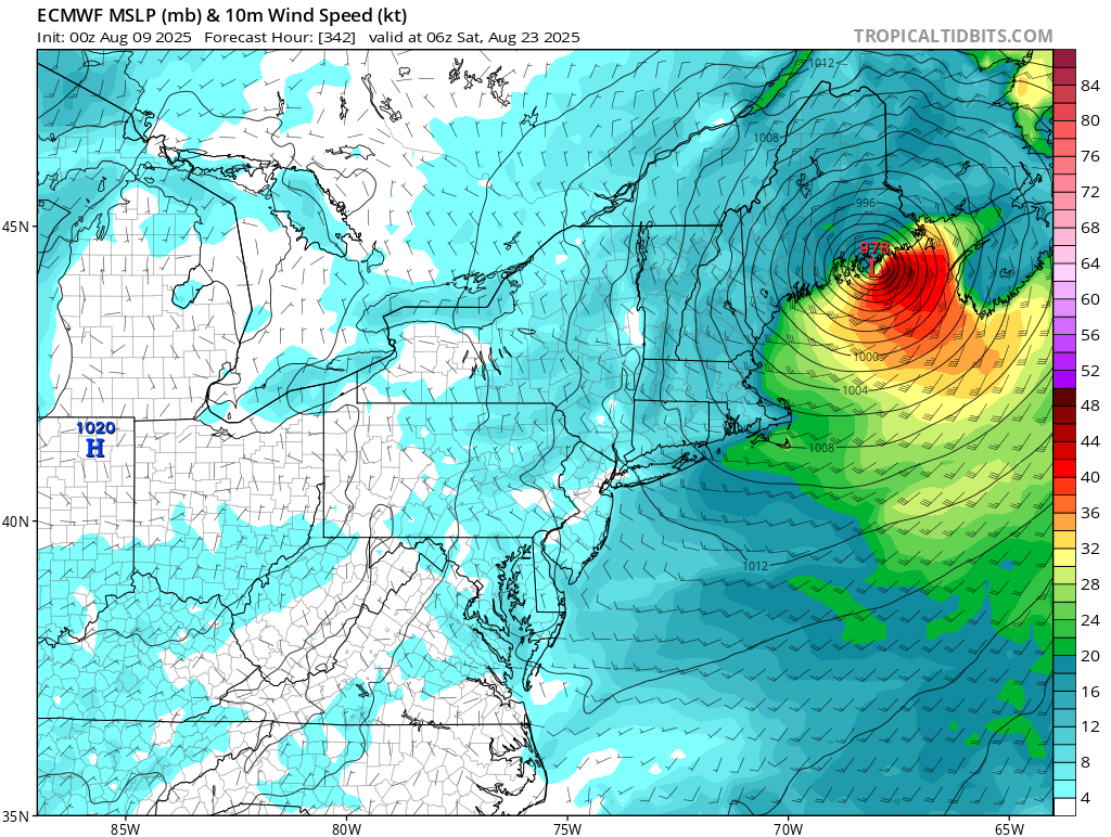
0z made landfall in eastern North Carolina, after getting close, but not over the Caribbean islands, and getting into parts of the Bahamas. The euro avoids both of those, and the Carolina coastline, but makes landfall in Massachusetts and again in Maine/Nova Scotia. avoids both.
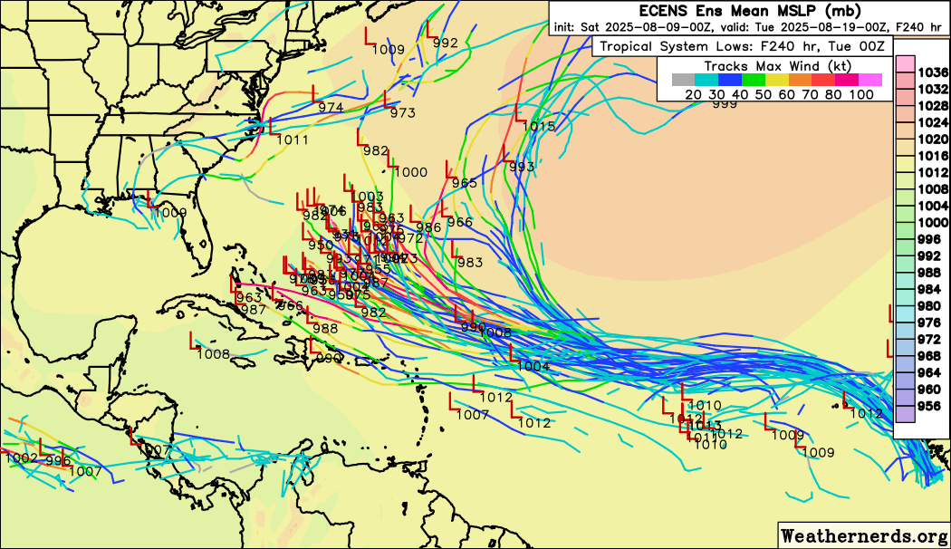
The good news is that the majority of ensembles of both the and Euro keep it offshore, however, it's not as much of majority as we would like. This system will likely need to be closely watched most of its lifetime for the Caribbean, Bahamas, Bermuda and the US/Canada.
0z at closest approach to Caribbean Islands
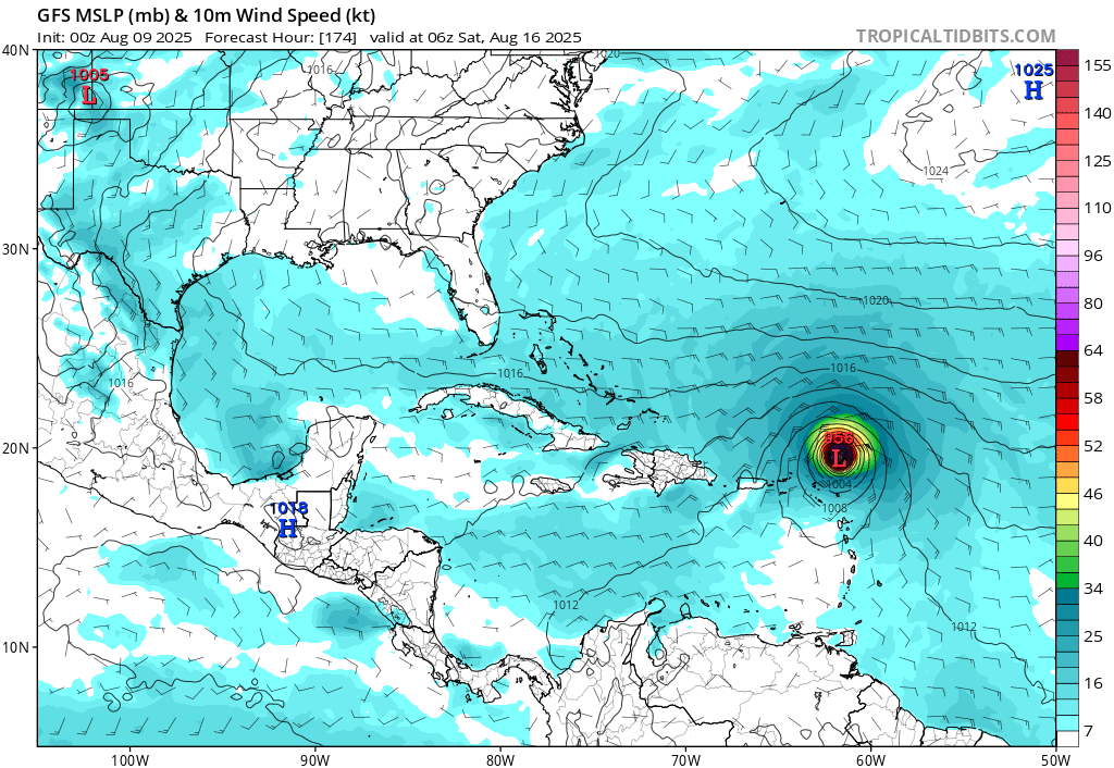
0z Bahamas
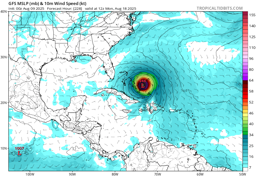
0z North Carolina:
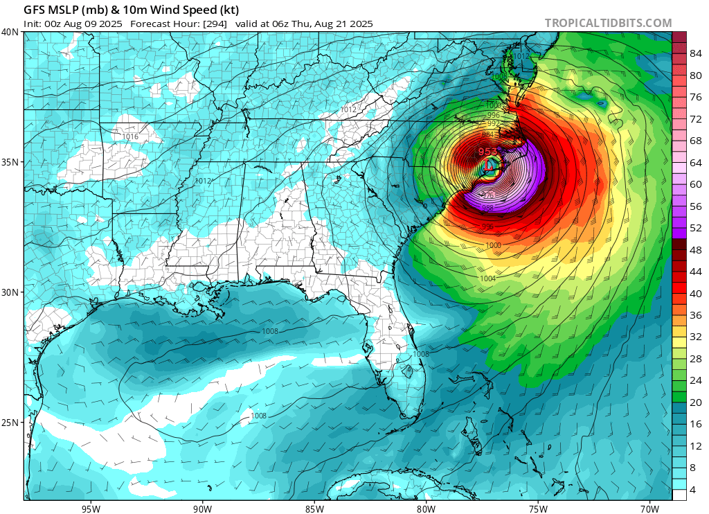
0z Euro Closest approach to North Carolina:
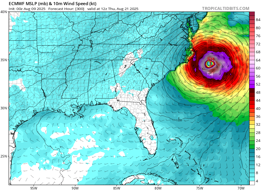
0z Euro Massachusetts Landfall
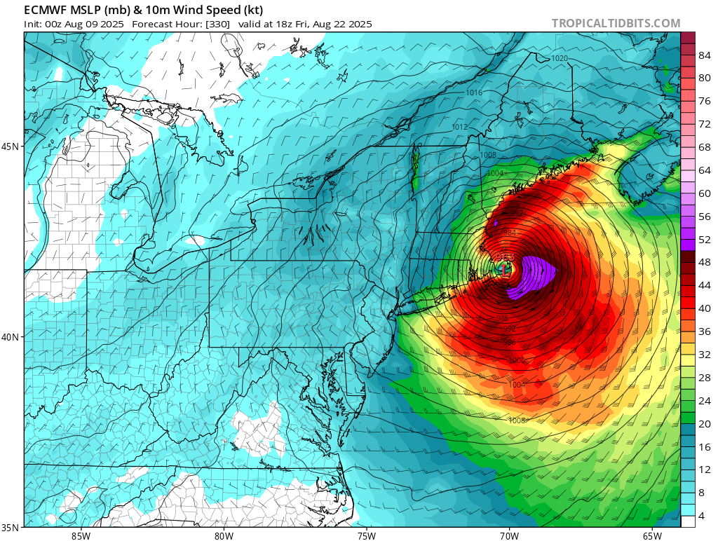
0z Euro Maine Landfall:
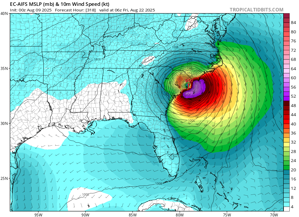
0z Euro AI South Carolina Landfall
0z Euro Ensembles
0z Ensembles (Watch how these trend over the days)
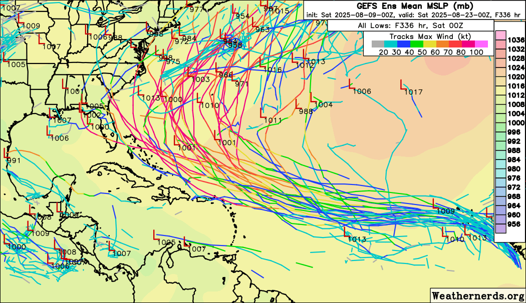
Sometime's we'll do a deep dive in a model run or two, but not all of them here. Models get more inaccurate the further out in time it is, you look for trends, persistence/consistency, and agreement between ensembles and individual runs the most. 5 day is decent, 10 day mark is ok, beyond that it gets rough. 3 day is better, but even not perfect.
Bottom line, the most likely outcome is for this system to stay offshore.
At 10:10AM Aug 11, put out a Special Update that 97L would be upgraded directly to Tropical Storm Erin with 45 MPH max sustained winds with Advisories to begin at 11, and the title has been updated accordingly.
-Ciel
Edited by cieldumort (Mon Aug 11 2025 10:50 AM)
|
MikeC
Admin
Reged:
Posts: 4870
Loc: Orlando, FL
|
|
The 6z curves the system out to sea just west of Bermuda, in the mid-range of the ensembles here. This is similar to yesterday's 18Z run. (the 12Z was all the way to Texas, so it's jumping around)
This system staying offshore remains the most likely outcome, but not by a comfortable margin. GEFS mean is west of the operational run, and is pretty close to the northeast. The overall spread runs from roughly the TX/LA Border to Bermuda beyond 10 days.
6z closest approach to Caribbean Islands

6z run staying east of the bahamas

|
MikeC
Admin
Reged:
Posts: 4870
Loc: Orlando, FL
|
|
Afternoon models, 12Z gets it closer to North Carolina, but does not landfall in the US, it Does landfall in Newfoundland in Canada though.
12z Canadian gets into the Bahamas.
12z Euro gets really close to Bermuda, but recurves just east of it.
Same idea holds, needs to be watched, but likely to stay offshore.
|
MikeC
Admin
Reged:
Posts: 4870
Loc: Orlando, FL
|
|
Bermuda needs to be watching this system very closely for sure. Caribbean Bahamas, US needs to monitor for changes, but changes, but odds are low it impacts us.
0z and 6z Recurve, 6z is over Bermuda. 0z Euro also does recurve it, but close enough to Bermuda to feel it.
GFS Ensembles are pretty adamant about a recurve, Euro ensembles less so. The Euro AI is the furthest left one, but not very realistic right now.
Odds still favor turning away from the US, and generally out to sea, but still worth monitoring. Bermuda needs to watch this very closely.
|
cieldumort
Moderator

Reged:
Posts: 2935
Loc: Austin, Tx
|
|

A fortuitous ASCAT pass from just a few hours ago clearly shows that 97L has now developed a fairly well-defined surface circulation. Conventional satellite images since that time also show that convection persists, but is still only loosely organized. However, only a small increase in organization would likely make 97L our next TD or possibly named storm as soon as later today.
While earlier TCG would generally favor an earlier turn to the north (and ideally for those of us in North America, a recurve out to sea), steering currents this far out are not set in stone.
|
cieldumort
Moderator
Reged:
Posts: 2935
Loc: Austin, Tx
|
|

Above: AIFS ENS 8/10/25/06z
The most recent run of the Euro AI (AIFS) ensembles above, from 06Z today, hint at a potential move towards the US at the most extended ranges.
A recent comparison study of the accuracy of the AIFS mean (black line in the above image) to the mean and mean showed a slight increase in skill over those two.
|
MikeC
Admin
Reged:
Posts: 4870
Loc: Orlando, FL
|
|
12Z and Icon shifted safely east of Bermuda. Also The 12Z shifted right to stay offshore (west of Bermuda). All are banking on a weakened Bermuda high to leave a trail with a hole in the ridge. How close the system gets to Bermuda is still a question, but barring a large change US impacts are unlikely. Still monitoring though, I'm not convinced the models are handling the ridge around Bermuda all that well.
|
MikeC
Admin
Reged:
Posts: 4870
Loc: Orlando, FL
|
|
Overnight models and ensembles have set up pretty well for a ridge to build and retrograde in with a trough in about 7-8 days, leading to a recurve of the system. Which is pretty healthy looking right now, but difficult to pinpoint location exactly so it's not being tracked as a depression or storm yet, it could later today though, but it's unlikely to develop much more for a few more days (maybe around 50 west), so development early on isn't really guaranteed, which is why I think the is holding classification. It's not a bad call given the environment ahead of it.
Bermuda needs to watch, the rest of us just need to monitor for changes, but they are honestly pretty unlikely. The northeast would be the most likely impacted if things were delayed a bit.
Models overnight kept it offshore (Except for Newfoundland) and west of Bermuda, event the euro AI. It's going to be close to Bermuda though, so those there need to watch the most. With the Canadian Maritime provinces being second. Anything else would need a pretty drastic change to the general trends, something to monitor for, but if anything it would shift recurve slightly east or west of the current ensemble means. Changes to look out for are any southwest dips and ridging changes.
|
MikeC
Admin
Reged:
Posts: 4870
Loc: Orlando, FL
|
|
18Z is southwest of the 6 and 12Z , but still remains offshore with no landfall. Watching general trends may take several days, as it stands 10% chance for US landfall, 90% not (includisve of that is another 10% chance for Bermuda) 2% chance for the Lesser Antilles. 15% for the Bahamas.
|
MikeC
Admin
Reged:
Posts: 4870
Loc: Orlando, FL
|
|
The hurricane models (HAFS) are like 3/4 degrees south of the official forecast position at 120 hours. (about 2 south of the 12Z model runs)
Waiting to see if this continues or not, each change like this shrinks the out to sea odds. (Which still dominate)
The official forecast for 120 hours is 22N, here is 18N, 12Z's run of HAFS B was 20.1N

|
MikeC
Admin
Reged:
Posts: 4870
Loc: Orlando, FL
|
|
Overnight model runs have kept back at the right, including the Hafs models, both are north of 20 north again.
Bermuda should watch closely.
It's still in monitoring mode in the Caribbean/Bahamas and US, but chances for direct impact on them are lower today than yesterday.
6z is very close to Bermuda on August 20th, euro is further west, but far enough east of North Carolina for no direct impacts except high surf.
The chances for US impacts are mostly in eastern North Carolina and new england, but unlikely for any direct impact.
For intensity, conditions aren't great in the Main Development Region, and easterlies are strong enough to keep it weak (or even have a mid/llc split for a period). But once past 60W conditions improve rapidly, especially around 50W where it'll likely be extremely conductive for development.
Two troughs, one to the northeast and another closer to Tennessee may have an impact down the road, so it's not completely clear cut. But between this is the lane out for a recurve. Meaning the Mid Atlantic, Bahamas, and Caribbean islands can't let any guard down, but Bermuda is still most likely to be closest to it.
|
OrlandoDan
Weather Master

Reged:
Posts: 462
Loc: Longwood, FL
|
|
Thanks for your expertise, as always, Mike.
|
Kraig
Weather Hobbyist

Reged:
Posts: 92
Loc: Jupiter, Fl
|
|
Given the lack of thunderstorms all day, I'm kinda surprised that has not downgraded Erin to a TD. Even the ASCAT pass this morning showed a single barb of 36kt, mentioned in the 11am discussion yet they didn't change the intensity when the same pattern continued all day. We have seen several unnamed systems in the last year or so, including 2 off the Carolinas last summer that had better organization, banding and measured winds to get at least TD if not TS status. And there is a great swath of dry air directly in the path of Erin, and the 19kt forward speed is bringing it very close to her moisture envelope. If Erin survives until Friday, she may get a second shot at survival. Curious to watch the next few days....
|
MikeC
Admin
Reged:
Posts: 4870
Loc: Orlando, FL
|
|
Overnight models runs, particularly the are highlighting Bermuda, or close, with the exception of the Icon which is much further left/southwest of the others. Bermuda could be in the cone around Saturday or Sunday, and if it were to impact Bermuda it would be 7-8 days out (Wed/Thursday next week).
I won't be going to Bermuda like I did for last year.
Today things to watch for are how far south Erin manages to get before starting to turn more due west and west northwest, and a smaller system southeast of Erin that may be part of the reason its being tugged south. The main difference between /Euro and the icon is the strength of the ridge to the Northeast of Erin. Pretty confident it'll turn out to sea before the US with all this, it's more about how much impacts Bermuda will get. Euro ensembles don't have any making US landfall now, still has 1/2. Vast Majority are close to Bermuda.
|
CFHC

Reged:
Posts: 217
Loc: East Central Florida
|
|
12z is west of Bermuda, 12Z icon is west of Bermuda, 12Z euro is WAY west of Bermuda, close enough for hurricane force winds in the outer banks (but no landfall).
Recon is flying out to St Croix (USAF) and Barbados (NOAA) now, tomorrow nights the first flights go out, so hopefully Friday and Saturday it'll help with the forecast.
|
MikeC
Admin
Reged:
Posts: 4870
Loc: Orlando, FL
|
|
18z Icon shifted way left as well. Enough to say it's worth watching.
I guess the wildcard here is whether or not there is a full trough that develops up over Newfoundland or so versus a trough split, which would allow the ridge to build back sooner and send this much more west.

|
MikeC
Admin
Reged:
Posts: 4870
Loc: Orlando, FL
|
|
Quite a bit of uncertainty is developing int he longer range, not that it won't turn north, but exactly when. It's likely a bit better news for Bermuda, but may be a little closer to the outer banks, but likely offshore still. May be strong enough to still cause some very heavy surf and erosion though.,
The ensembles shifted slightly left, where the Euro shifted right. The 's track is along the right side of most ensembles now which if extrapolated, would mean it would likely wind up midway between North Carolina and Bermuda, maybe slightly closer to Bermuda. A lot depends on the ridge and the trough near Newfoundland, but that possibility seems the most likely right now. Icon did shift quite a bit left at 0z, but 6z move back a bit, so the indicators of a left correction later yesterday at least halted.
Still a lot could happen in the next few days, so it's important to keep watching it. track seems good right now. Recon tonight, and especially tomorrow should help solidify the longer term track better by Friday evening.
The reason I think recon is going to be vital, the 6z ensembles show a pretty big spread still, and all have moved west of Bermuda. (I typically like to use bermuda as a baseline for recurving systems). With several members into the US, but most east of it.
|
IsoFlame
Weather Analyst

Reged:
Posts: 418
Loc: One block off the Atlantic Oce...
|
|
Quote:
Quite a bit of uncertainty is developing int he longer range, not that it won't turn north, but exactly when. It's likely a bit better news for Bermuda, but may be a little closer to the outer banks, but likely offshore still. May be strong enough to still cause some very heavy surf and erosion though.
Afternoon/evening high tides all next week are the highest of the month based on lunar cycle, peaking Tuesday-Thursday at 3.7 feet. Hurricane ground swell run-up will surely reach the condo sea walls in the area where I live in Daytona Beach Shores, scouring away some of the sand that has managed to accumulate since Hurricane Milton. A major sand renourishment project recently planted with sea oats south of the Sun Glow pier will probably take a pretty good hit too.
--------------------
CoCoRaHS Weather Observer (FL-VL-42) & Surf Forecaster: https://www.surf-station.com/north-florida-surf-forecast-3/
|
MikeC
Admin
Reged:
Posts: 4870
Loc: Orlando, FL
|
|
Now with some recon data, models are aligning on the between Bermuda and North Carolina route, with differences on how close to one or the other is it. Even the icon, which is still the furthest left, started going back to the right. The other close approach is Newfoundland, but none of the models make landfall there either.
Story will be heavy surf and erosion along the areas the Erin gets closes to.
I think Erin is mixed this morning, better structure but getting hit by a streamer too, all under relatively high pressure, short term oddness to shake out. Wherever the area of convection currently just off North Carolina goes is probably where Erin gravitates to when it gets up there
|
cieldumort
Moderator
Reged:
Posts: 2935
Loc: Austin, Tx
|
|
Erin may now be a Cat 5 already and has been tracking south of forecast for eight hours or so. This potentially puts ICON much more in play, the outlier model that has been consistently deeper and with a much further west track than all the other Globals (and so was written off and not included in consensus aids and the like). Time to give ICON another look for this particular hurricane; certainly more than a footnote.
|


 Previous
 Index
 Next
 Threaded


 Edit
 Reply
 Quote


