CFHC

Reged:
Posts: 149
Loc: East Central Florida
|
|
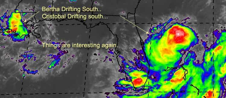
Tropical Storm Cristobal has formed from Tropical Depression Three. Currently moving southward. It is forecast to move away from land, and spin the fish mildly, but we'll watch it just in case. Steering winds aren't all that well defined right now.
As that moves outward another interesting possibility is that Berta might show up again. As it is currently moving south (very slowly) Although the chances of this happening are low, it's still worth a watch. Louisiana is getting buckets of rain. If it does move back over the gulf then I hope you folks in Texas haven't forgotten about Bertha. It could regain itself fairly fast. If it does, we'll be on it.
Graph for Bertha (again)
code:


forget it) 0 1 2 3 4 5 6 7 8 9 10 (sure thing)


          [-----*----------------]
We'll be watching.
NASA GHCC Interactive Satellite images at:
North Atlantic Visible (Daytime Only), Infrared, Water Vapor
Some forecast models:
NGM, AVN, MRF, ETA ECMWF
DoD Weather Models (NOGAPS, AVN, MRF)
AVN, , , , , UKMET
Other commentary at Mike Anderson's East Coast Triopical Weather Center, Accuweather's Joe Bastardi, Hurricane City, Gary Gray's Millennium Weather, Barometer Bob's Hurricane Hollow Even more on the links page.
- [john@flhurricane.com]
|
ShawnS
Storm Tracker
Reged:
Posts: 226
Loc: Pearland,Tx
|
|
I've been checking out some of the buoys off of the upper Texas and La. coasts and let me tell you, THE PRESSURES ARE DROPPING AND DROPPING FAST! One of the buoys just south of Galveston went from 29.95 at 2:00 to 29.88 at 7:00 and it is still dropping. The buoy off of the La. coast has had the same kind of pressure drop.Bertha is not even off shore yet and this is happening. I read on tropicalweatherwatchers.com that she could possibly strengthen rapidly once over water. The only thing is it looks like it could move towards deep south Texas before it would hit land. WOW!!! Of course, it could get out there and not do a darn thing. At least we have some excitement out there.
|
Steve
Senior Storm Chaser

Reged:
Posts: 1063
Loc: Metairie, LA
|
|
I got a research idea for Kevin. How do seasons that have had three minimal (tropical, cat-1) storms by August 6th compare?
I agree Shawn. At least things are interesting. I've got a few ideas that I want to see how they pan out.
Bertha - definitely heading toward the Gulf. The front isn't far behind and is very strong. Shear should eventually catch Bertha unless she gets pretty far south. Over the last few days, Bertha has been firing up late at night and peaking by noon. Does she have it in her to continue this trend for 2-3 more days? And will Bertha fire up some severe weather in response to the front at some point tonight or tomorrow? Then finally, where does the front stall (if it doesn't split) in relation to Bertha down the road? Is the low level moisture waiting to flare up in the wake of the front - say in South Texas or down in the BOC late this weekend? Or does she become a rainmaker for lower texas and the deserts of Mexico?
Cristobal - He's an asymetrical storm with an odd wind field. The lowest pressure (999mb and falling according to Accuweather's 7:30 hurricane update) is exposed and to the north of the main convection. If a new mid or low level center doesn't form further south with the convection, it's probably going to head east then out to sea as the has been saying. However, if it continues to move south or if a new LLC forms further s-sw, then it's anyone's guess. This could hit the peninsual and cross into the gulf. It could stay trapped in a weak flow. Tough call. The key is also the push of the cold front. If the push is strongest to the south, christobal spins fish. If the push is stronger to the southeast, then it's trapped or heading towards the east coast of Florida.
This all should make for an interesting tomorrow. We've got a nice little string of some homegrown stuff going on.
Steve
--------------------
MF'n Super Bowl Champions
|
WXMAN RICHIE
Weather Master

Reged:
Posts: 463
Loc: Boynton Beach, FL
|
|
We have a Tropical Storm only 300 miles from Florida that is moving south and the highest probabilities for the entire east coast are for Nova Scotia and Newfoundland, Canada. I guess they are sure about the future motion away from Florida. Go figure.
--------------------
Another typical August:
Hurricane activity is increasing and the Red Sox are choking.
Live weather from my backyard:
http://www.wunderground.com/weatherstation/WXDailyHistory.asp?ID=KFLBOYNT4
|
Keith L.
Unregistered
|
|
O.K. I'm a little upset, and I'd like people to respond. Tropical Cyclones are my hobby and they are very intriguing and dangerous. I wouldn't wish them on anyone yet you can't help but marvel at their awesome power. Here's my concern. I live on Big Pine Key in the Florida Keys. I watch this board daily, perhaps too often but there could be worse addictions. We had T.D. 3 moving E at that point. At least the TPC said it was moving east. It's the first day of lobster season down here, I had the day off from work so we were on the water all day. At noon we had fair sky's as the day went on the sky became milky white. Now if a storm is moving east that is supposedly over 30.5 N which is above Jacksonville then why am I seeing the sky become overcast in the Florida Key's.
My main point is that the TPC should be looking out for the publics interest. If this storm decides to move SW it's only hours away from the Florida coast. We are diehard weather folks who are always looking for angles. What about the regular people who believe whatever the local or in this case the national weather folks say. They would never know that a potentially damaging storm is only hours away.
My goal is not to point fingers. It's only to bring the point up that Cristobal is listed at being above 30 degrees north when in fact there is NOTHING above that that latitude as we speak. In fact most of the precip is parallel with Central Florida. What I want is an agency that gives us all of the options (know matter how crazy) like Joe Bastardi. That way we can make our own assumptions and perhaps give people a few MORE days notice when bad weather approaches.
Look at this storm and imagine if it moved 200 miles west and pulled an Opal? Even if the chance was 10% wouldn't you want to know? I'll get off my soap box now. Thank you for reading.
Keith
|
tom5r
Weather Watcher
Reged:
Posts: 49
Loc: Islamorada, Florida
|
|
just this morning I scoffed at TD-3 calling it "something for our entertainment pleasure." I never thought it would become anything. Now my neighbors and myself are becoming a bit concerned about it. Special note to Shawn, you've been correct all day. If Cristobal hits the Florida Straights it can go crazy. Lord only knows where it may be headed. 
|
WXMAN RICHIE
Weather Master
Reged:
Posts: 463
Loc: Boynton Beach, FL
|
|
Storm now due east of St. Augustine and still moving south. Check the radars from Melbourne and WPB, rains getting closer, less than 100 miles from coastline.
--------------------
Another typical August:
Hurricane activity is increasing and the Red Sox are choking.
Live weather from my backyard:
http://www.wunderground.com/weatherstation/WXDailyHistory.asp?ID=KFLBOYNT4
|
Keith L.
Unregistered
|
|
Discussions are probally going on right now at the . Yet most of America is going to bed. What could a storm possibly do in 10 hours? Am I being sarcastic, ........yes!!!
Why aren't the options being forecast?????
Keith
|
57497479
Weather Master

Reged:
Posts: 414
Loc: W. Central Florida
|
|
Hey guys, do you know how I know when a storm is comming my way? When the TPC/ says it's going some place else.If they start off with my area as land fall, then it goes some place else! I know that I am being pretty critical tonight, but do they think that we came down in yesterdays rain? My lesson was Elena in 85. We were reassured that all danger had passed us then that night around midnight I was standing in long lines at the local grocery store looking for supplies. Since that time I've done my own hurricane watching. Lesson learned, ALWAYS BE PREPAED.  T. LEAP T. LEAP
--------------------
TONI
All of us could take a lesson from the weather:
It pays no attention to criticism
My 2003 Hurricane guess 13-9-3
|
Houstontracker
Unregistered
|
|
AT 10 PM CDT...0300Z...THE CENTER OF TROPICAL DEPRESSION BERTHA WAS
LOCATED NEAR LATITUDE 29.6 NORTH...LONGITUDE 91.3 WEST... OVER SALT
POINT LOUISIANA.
BERTHA HAS DRIFTED SLOWLY SOUTHEASTWARD OVER THE PAST SIX
HOURS. HOWEVER...MODEL GUIDANCE AND SATELLITE IMAGERY SUGGEST
THE RESUMPTION OF A MORE SOUTHWESTERLY TRACK OVER THE NEXT 12
HOURS. THIS TRACK WOULD BRING BERTHA OVER SOUTH CENTRAL
LOUISIANA AND POSSIBLY THE ADJACENT COASTAL WATERS IN THE NEXT 24
HOURS. LITTLE CHANGE IN INTENSITY IS EXPECTED WHILE
THE CENTER IS OVER LAND. REFER TO THE TROPICAL WEATHER OUTLOOK
ISSUED BY THE TROPICAL PREDICTION CENTER UNDER AWIPS HEADER
TWOAT AND WMO HEADER ABNT2O KNHC FOR THE POTENTIAL FOR
REINTENSIFICATION IF BERTHA REEMERGES OVER THE GULF COASTAL
WATERS.
MAXIMUM SUSTAINED WINDS ARE 13 MPH. ESTIMATED MINIMUM CENTRAL
PRESSURE IS 1011 MB. NO SIGNIFICANT CHANGE IN STRENGTH IS EXPECTED
IN THE NEXT 12 HOURS.
Hard to tell whats going on, but this is right on the coast SSE of Lafayette so I guess she's just about back over water. Guess we will know more in the morning.
|
57497479
Weather Master
Reged:
Posts: 414
Loc: W. Central Florida
|
|
OK Keith, on the 11p update the word is that the steering currents are not presently well defined and erratic movement is possible. I suppose that means that it has been in a erratic stage all day. P.S. they still are predicting that slow E/NE turn. I hope their right! T. Leap
--------------------
TONI
All of us could take a lesson from the weather:
It pays no attention to criticism
My 2003 Hurricane guess 13-9-3
|
57497479
Weather Master
Reged:
Posts: 414
Loc: W. Central Florida
|
|
In addition to the update read discussion #7 from the NWS. They are now discussing the possibility that the NE turn may not happen
T. Leap
--------------------
TONI
All of us could take a lesson from the weather:
It pays no attention to criticism
My 2003 Hurricane guess 13-9-3
|
Jason M
Weather Watcher
Reged:
Posts: 39
Loc: New Orleans
|
|
FORECAST POSTED: 8/07/02/ 6:00 AM EDT
CURRENT ACTIVE ATLANTIC STORMS...
Tropical Storm Christobal
National Hurricane Center
AT 5 AM EDT...0900Z...THE CENTER OF TROPICAL STORM CRISTOBAL WAS LOCATED NEAR LATITUDE 29.5 NORTH...LONGITUDE 76.2 WEST OR ABOUT 310 MILES...500 KM...EAST OF ST. AUGUSTINE FLORIDA.CRISTOBAL IS MOVING TOWARD THE SOUTH NEAR 3 MPH ... 6 KM/HR. MAXIMUM SUSTAINED WINDS ARE NEAR 45 MPH... 75 KM/HR...WITH HIGHER GUSTS. ESTIMATED MINIMUM CENTRAL PRESSURE IS 999 MB...29.50 INCHES.
Despite the latest advisory from the indicating a southward movement, the center appears to be moving more easterly. If this is the case, Christobal should easily get forced NEWD by the upper level trough to the north. The models are still indicating that this is still the most likely scenario.
What bothers me, is the convection southwest of the center of circulation. The cloud tops began to warm a few hours ago with the center becoming more exposed. Now, the center is continuing to become even more exposed. However, convection is beginning to refire once again south and west of the center. This concerns me because there is always that chance that a new center could form. IF a center would form that far south and west, Florida would be under the gun. However, besides the convection beginning to refire, there are no signs of this beginning to take place. Now if we begin to see a swirl farther south and west later today on visible satellite imagery, I would start talking about a greater chance of a landfall. But unless that happens, a slow easterly movement with a curve to the northeast remains likely. We will be monitoring the situation closely.
The intensity forecast also depends on the forecast track. If the trough and center move too close to each other, they may just merge and further development wouldn't occur. If the center slowly begins to move east and then northeast, winds would likely increase to near 60MPH as the energy from the trough would aid the system.
Now if the second track scenario were to take place, we would just see Christobal meandering around across the Bahamas. With the trough moving away, vertical shear would begin to decrease. Of course this would allow Christobal to easily strengthen further possibly to hurricane status. But we won't worry about this unless we begin to see evidence of a new center forming which there is no evidence of this happening as of yet.
I will try my best to update the discussions at around noon...but nothing is a garauntee. I am sorry for any inconveniance this may cause.
CURRENT ACTIVE EPAC STORMS...
TROPICAL DEPRESSION SEVEN- E
TROPICAL DEPRESSION CENTER LOCATED NEAR 17.4N 124.3W AT 07/0900Z POSITION ACCURATE WITHIN 45 NM. PRESENT MOVEMENT TOWARD THE NORTHWEST OR 310 DEGREES AT 11 KT
ESTIMATED MINIMUM CENTRAL PRESSURE 1008 MB MAX SUSTAINED WINDS 30 KT WITH GUSTS TO 40 KT. WINDS AND SEAS VARY GREATLY IN EACH QUADRANT. RADII IN NAUTICAL MILES ARE THE LARGEST RADII EXPECTED ANYWHERE IN THAT QUADRANT.
Tropical depression #7 will not pose a threat to any landmasses and is not expected to strengthen.
FORECASTER Jason Moreland, TWWFT
--------------------------------------------------------------------------------
DISCLAIMER: THIS IS NOT AN OFFICIAL FORECAST. PLEASE LISTEN TO YOUR LOCAL NEWS OR THE National Hurricane Center FOR THE LATEST INFORMATION.
http://www.tropicalweatherwatchers.com
--------------------
http://www.independentwx.com
|
Jason M
Weather Watcher
Reged:
Posts: 39
Loc: New Orleans
|
|
FORECAST POSTED: 8/07/02/ 6:35 AM EDT
ATLANTIC TROPICAL WEATHER OUTLOOK:
We are still watching the remants of tropical storm Bertha. The HPC has written te last advisory on the system and Bertha is no longer a tropical depression. The center of circulation has just moved off of the central Louisiana coast and is now over the northern Gulf of Mexico. Some redevelopment is possible. However, there is an upper level low near the mouth of the Mississippi River moving WSW. This low will cause conditions across the northern Gulf to become marginal, at best for redevelopment. By the time the upper low moves out of the picture, the remnants of Bertha may be inland over southern Texas. We will still be keeping a close eye on the remnants of Bertha.
The area that concerns me the most besides Bertha and Christobal, is the central and southeast Gulf of Mexico. The models are indicating a possible developing low in the southeastern Gulf of Mexico in a few days. The odels may be hinting on a pice of energy that may brake off from the trough to the north. OR, this could be the convection you see just east of Florida. I made note of this in my active storms discussion. What may happen, is that the low level center may move east, and leave all fo the convection behins. This is just speculation since the models are the only thing indicating a low center in the area. VERY interesting.
The remainder of the Atlantic basin is quiet. We do see an approaching wave near 40W but the wave won't have much of a chance as it is moving into a shear environment.
Tropical storm formation is not expected through Friday.
FORECASTER: Jason Moreland, TWWFT
--------------------------------------------------------------------------------
DISCLAIMER: THIS IS NOT AN OFFICIAL FORECAST. PLEASE LISTEN TO YOUR LOCAL NEWS OR THE National Hurricane Center FOR THE LATEST INFORMATION.
http://www.tropicalweatherwatchers.com
--------------------
http://www.independentwx.com
|
Anonymous
Unregistered
|
|
DR. Gray has lowered his numbers for 2002 by 2 storms:
9 named storms
4 hurricanes
1 intense hurricane
That is all.
Cheers!! Steve H.
|
ShawnS
Storm Tracker
Reged:
Posts: 226
Loc: Pearland,Tx
|
|
Well, I said that Bertha could emerge back over the water and not do a darn thing and it looks like that is what she has chosen to do. I guess she didn't have enough left after all. I guess we won't see too much rain in our area because of her deciding to make a silent exit.
|


 Threaded


