palmetto
Verified CFHC User
Reged:
Posts: 23
Loc: Tallahassee, FL
|
|
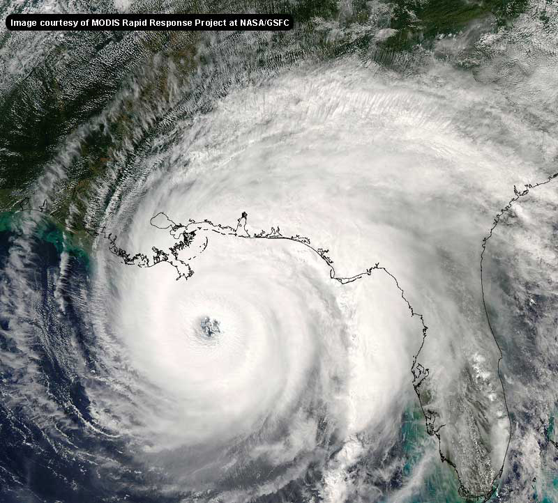
Not even sure that this is the right forum, and the mods are more than welcome to edit this if I'm wrong--but what the heck is that in the GOM to the west of Tampa? Just a big blob (such scientific terminology, I know) of thunderstorms or what?
This hurricane season has me on edge to the point where everything has me suspicious. Weather paranoia, the latest craze. 
|
Kdubs
Weather Watcher

Reged:
Posts: 44
Loc: Orlando, FL
|
|
Well, I just finished updated my mother on the progress of . She suggests that scientists stop studying the life cycles of earthworms and start trying to find a way to get rid of a hurricane, whether through artificial steering currents, NON-nuclear warheads, pressure inflators, big nets, clowns, whatever will work. A little late for this hurricane season, but it sure would be nice to steer out into the open waters and let him die.
--------------------
South Orlando 
God Bless
A B C D E F G H I J K L
Bold = Reached hurricane status
Italics = Impacted Florida
|
bill095
Unregistered
|
|
(off-topic & off-color post removed by moderator)
Edited by LI Phil (Thu Sep 09 2004 08:12 PM)
|
trinibaje
Weather Guru
Reged:
Posts: 136
Loc: MIAMI, FLORIDA
|
|
Quote:
Well, I just finished updated my mother on the progress of . She suggests that scientists stop studying the life cycles of earthworms and start trying to find a way to get rid of a hurricane, whether through artificial steering currents, NON-nuclear warheads, pressure inflators, big nets, clowns, whatever will work. A little late for this hurricane season, but it sure would be nice to steer out into the open waters and let him die.
LOVE IT... YOUR MOM'S A GENIUS! 
--------------------
-----------MY 2005 PREDICTION--------
15/10/5
|
Ed in Va
Weather Master
Reged:
Posts: 489
Loc:
|
|
Kdubs,
In the late 50s or early 60s, there was, as I seem to remember from the time, some effort to try to seed canes so they would rain themselves out over the ocean. Seems like there was some limited, though very temporary, success. Maybe someone else on the forum has more info.
--------------------
Survived Carol and Edna '54 in Maine. Guess this kind of dates me!
|
LI Phil
User

Reged:
Posts: 2637
Loc: Long Island (40.7N 73.6W)
|
|
Before ANYONE posts on you-know-what, check out this FAQ from .
This should answer any questions about altering hurricanes.
--------------------
2005 Forecast: 14/7/4
BUCKLE UP!
"If your topic ain't tropic, your post will be toast"
|
recmod
Weather Guru

Reged:
Posts: 188
Loc: Orlando, FL
|
|
dyna-who..?
NOT funny (LOL)
Edited by LI Phil (Thu Sep 09 2004 08:13 PM)
|
jimm034
Unregistered
|
|
its scary to ask but could this thing strenghten?
|
SirCane
Storm Tracker

Reged:
Posts: 249
Loc: Pensacola, FL
|
|
For all folks along the Gulf Coast from New Orleans to the FL Keys....
Quote:
Ivan is moving toward the west-northwest at 13 knots. This general
motion with a gradual decrease in forward speed is expected during
the next 3 days. There high confidence in this portion of the
forecast because the hurricane will be steered by the flow
surrounding a well-established subtropical ridge. All models are highly clustered during this period...bringing the hurricane
between Cuba and the Cayman Islands. Thereafter...the forecast
track becomes highly uncertain.
|
CoachH
Registered User
Reged:
Posts: 1
|
|
This is my first post though I've been reading regularly since . I really appreciate all the effort and energy people have spent keeping us informed of the latest. I live in South Polk county, FL and we have been hammered twice in the last few weeks. It's almost like everyone is just in a daze that another strike could be coming. The good news is that we are all prepared but since there are still some without power and the grids are stretched thin, a Category 3 or higher could mean long outages. Until then, we hope for the best but expect the worst. BTW, Would 3 Hurricane center circulations passing through one county in a months time span be some kind of record? :-)
|
recmod
Weather Guru

Reged:
Posts: 188
Loc: Orlando, FL
|
|
Looking at the latest WV and IR loops, I'm noticing that the deep convection is starting to return in a large "doughnut" around the well-defined eye....this is right about the same time as yesterday's intensification run.....
That, coupled with the latest vortex showning a slightly lower pressure than earlier, makes me believe might be trying to get even stronger this evening.
--Lou
|
nick_in_st.pete
Unregistered
|
|
A great site to see the latest model runs is maintained by the Southwest Florida Water Management District. They have the very latest models clearly labeled with a date and time. You can find it at...
http://www.sfwmd.gov/org/omd/ops/weather/plots/storm_09.gif
|
WXMAN RICHIE
Weather Master

Reged:
Posts: 463
Loc: Boynton Beach, FL
|
|
LOCAL FORECASTS REFLECT THE OFFICAL FORECAST. EXPECT CONDITIONS TO START TO DETERIORATE ON SUNDAY WITH GOOD POTENTIAL FOR STRONG WINDS AND HEAVY RAINS MONDAY.
--------------------
Another typical August:
Hurricane activity is increasing and the Red Sox are choking.
Live weather from my backyard:
http://www.wunderground.com/weatherstation/WXDailyHistory.asp?ID=KFLBOYNT4
|
Ed in Va
Weather Master
Reged:
Posts: 489
Loc:
|
|
5 discussion....moving somewhat to west and weakening over time:
BOTH NOAA AND AIR FORCE RECONNAISSANCE PLANES HAVE BEEN IN THE EYE
OF DURING THE PAST FEW HOURS. MINIMUM PRESSURE REMAINS AT
ABOUT 921 MB BUT MAXIMUM FLIGHT LEVEL WINDS HAVE DECREASED TO 144
KNOTS. THIS SUGGESTS THAT INITIAL INTENSITY CAN BE LOWERED TO 130
KNOTS AT THIS TIME. THERE WERE SOME INDICATIONS FROM MICROWAVE
DATA AND NOW CONFIRMED WITH THE PLANE THAT HAS A DOUBLE
EYEWALL STRUCTURE. THIS MAY EXPLAIN THE RECENT SLIGHT WEAKENING.
THE HURRICANE WILL PROBABLY FLUCTUATE BETWEEN CAT 4 AND 5 WHILE
MOVING THROUGH AN AREA OF LOW SHEAR AND HIGH OCEANIC HEAT CONTENT
BEFORE REACHING CUBA. THEREAFTER...THE EFFECTS OF LAND AND
INCREASING SHEAR WILL CAUSE A GRADUAL WEAKENING.
IVAN CONTINUES TO MOVE TOWARD THE WEST-NORTHWEST OR 300 DEGREES AT
13 KNOTS. THIS GENERAL MOTION WITH A GRADUAL DECREASE IN FORWARD
SPEED IS EXPECTED DURING THE NEXT 2 TO 3 DAYS. AS MENTIONED IN THE
PREVIOUS DISCUSSION...THERE IS HIGH CONFIDENCE IN THIS PORTION OF
THE FORECAST BECAUSE THE HURRICANE WILL BE STEERED BY THE FLOW
SURROUNDING A WELL-ESTABLISHED SUBTROPICAL RIDGE. ALL MODELS ARE
HIGHLY CLUSTERED DURING THIS PERIOD...BRINGING THE HURRICANE
NEAR OR OVER JAMAICA...THE CAYMAN ISLANDS AND WESTERN CUBA WITH A
DECREASE IN FORWARD SPEED. THEREAFTER...THE TRACK CONTINUES TO BE
UNCERTAIN SINCE STEERING CURRENTS ARE FORECAST TO WEAKEN AND MODELS
DIVERGE. HOWEVER...MODELS FROM 12Z ARE IN SLIGHTLY BETTER AGREEMENT
THAN IN EARLIER RUNS...AND IN GENERAL HAVE SHIFTED A LITTLE BIT
WESTWARD. THE OFFICIAL FORECAST ALSO SHOWS A SLIGHT WESTWARD SHIFT.
THE WIND RADII WERE ADJUSTED BASED ON THE STEPPED FREQUENCY
MICROWAVE RADIOMETER DATA ONBOARD THE NOAA P3 PLANE CURRENTLY
INVESTIGATING .
FORECASTER AVILA
FORECAST POSITIONS AND MAX WINDS
INITIAL 09/2100Z 15.0N 72.5W 130 KT
12HR VT 10/0600Z 16.1N 74.2W 130 KT
24HR VT 10/1800Z 17.5N 76.2W 135 KT
36HR VT 11/0600Z 18.8N 78.0W 130 KT
48HR VT 11/1800Z 19.7N 79.3W 140 KT
72HR VT 12/1800Z 21.5N 81.5W 140 KT
96HR VT 13/1800Z 25.0N 83.0W 115 KT
120HR VT 14/1800Z 28.0N 83.5W 100 KT
--------------------
Survived Carol and Edna '54 in Maine. Guess this kind of dates me!
|
Sam33
Unregistered
|
|
interesting that the forecast path of is much more to the left than .... tue am..... center looks to be due south of panama city florida, almost due west of ft. myers....hmmm..... based on 3:30 show
|
bobbi
Unregistered
|
|
Has anyone discussed how the build up of activity in the Gulf might affect ?
|
LI Phil
User

Reged:
Posts: 2637
Loc: Long Island (40.7N 73.6W)
|
|
Anyone know if (or when) Stacy Stewart will be doing the discussion?
--------------------
2005 Forecast: 14/7/4
BUCKLE UP!
"If your topic ain't tropic, your post will be toast"
|
MikeC
Admin
Reged:
Posts: 4544
Loc: Orlando, FL
|
|
Those looking to put storm info on their webpage can use this bit of html script
<script src="http://flhurricane.com/stormlist.html"></script>
Which will show the storm info like it does on the left bar
|
SirCane
Storm Tracker

Reged:
Posts: 249
Loc: Pensacola, FL
|
|
Can't believe it will weaken that much. That's good though! But still dangerous. 
|
Colleen A.
Moderator

Reged:
Posts: 1432
Loc: Florida
|
|
Hopefully, soon. Maybe the next advisory?
When the NWS starts talking about heavy wind and rain in your area...you know. I noticed last night that from Friday to Tuesday, we aren't having any wind at all. That tells me they are waiting waiting waiting........
--------------------
You know you're a hurricane freak when you wake up in the morning and hit "REFRESH" on CFHC instead of the Snooze Button.
|


 Threaded


