MikeC
Admin
Reged:
Posts: 4622
Loc: Orlando, FL
|
|
10:00pm
Dennis is now a category 4 storm with a pressure is 951 mb. 135mph winds, gusts to 160 mph. The next advisory update will reflect this. New forecast insight from Clark now available below or on the Met Blogs (available at left).
9:30pm
Latest Recon report suggests is now a Category 4 storm. More to come soon. T Numbers of 6.0 also suggest this.
7:45pm
At 8PM, is now a very strong Category 3 storm, bordering on Category 4. It still has room for strengthening.
Pressure is down to 951 millibars and dropping.
Also, in the eastern Atlantic, another Tropical Wave is crossing the Atlantic.
Jim Williams is doing an audio show tonight over at Hurricane City if you have real player, you can listen in With this link
Original Update
is strengthening, probably a few more miles an hour at 8PM. No reason right now to adjust the track. But the cone of error still exists, and until the storm is in the Gulf, it would be wise for all to watch it and not assume that it will verify as shown now. Much depends on the ridge to the east of Florida now.
Recon Aircraft have found the eye to be completely closed off now, and pressure to be a few mb lower. So 8PM should up the speed. It has a running chance to get to be a category 4 before landfall in Cuba. Not good news for Cubans.
The warnings are up in the lower keys and evacuations are underway. There is a fair chance that will cross over or just west of Key West, so it is VERY IMPORTANT to heed emergency management suggestions there. Be prepared.
More to come later...
 
Keys Close up:


Note: These talkbacks are now in lockdown mode, which means that unregistered users cannot reply.
You can still post in the other forums besides talkbacks. This enables us to moderate a lot better. I hate doing this, but I can see obvious signs of "storm stress" on a few individuals. We'll make it open again as soon as it calms down.
Registration is open for anyone, you can register Using this link. Then you will be able to reply here.
Hopefully this will only last a short time.
Event Related Links
Monroe County/Florida Keys Emergency Management Bulletins
StormCarib hurricane reports from observers in the Islands - Jamaican StormCarib Reports
Caribbean Island Weather Reports
Jamaican Meteorological Service
Guantanamo Bay, Cuba Radar
Florida Keys Long Range Radar Loop
Tampa Bay, FL Long Range Radar
Miami, FL Long Range Radar
Dennis
Animated Model Plot of
Model Plot Graphic from the South Florida Water Management District of
Dennis Spaghetti Model from boatus
Weather Underground Model Plots for
Quikskat Image of
Color Sat of
Floater Satellite (Visible) of with Storm Track Overlays
Cienfuegosa, Cuba Radar - (Animated)
RAMSDIS high speed visible Floater of
Forecast Discussions for (Show All Locations):
Tampa. Mobile Bay,
New Orleans, Key West, Tallahassee.
Melbourne
|
OrlandoDan
Weather Master

Reged:
Posts: 447
Loc: Longwood, FL
|
|
I see that there is a "possibility" that the ridge to the east will weaken and that there is a "possibility" that will take a more "right" track. Any comments from the experts?
|
FireAng85
Weather Hobbyist
Reged:
Posts: 76
Loc: Mount Dora, FL 32757
|
|
Yes, inquiring minds want to know. The local mets in Orlando keep telling us that this is a "possibility", like they want to tell us, yes, we are going to have rough weather, please board up!
--------------------
Angie Robertson
OCFRD
"So others may live"
|
Jeffmidtown
Weather Guru

Reged:
Posts: 132
Loc: Atlanta, Ga
|
|
Hey everyone, checking in again from Atlanta.... 24 hours after Cindy started to affect the metro Atlanta, preliminary storm totals are starting to come in and this may be a very expensive storm. In Henry County, Ga. home of Atlanta Motor Speedwy, the officials there place a preliminary estimate of damage at $100 million in that county alone, with almost incredible devastation from an F-2 tornado that started in the infield of AMS. That total DOES NOT include some 300 homes that were damaged or destroyed.
It bears repeating yet again, if you are to the right front quadrant of a landfalling tropical system even as far inland as us here in Atlanta, you are at risk for flooding rains, dangerous lightning and tornadoes.
--------------------
You know it's a bad day.....when you wake up and see Jim Cantore and Geraldo Rivera broadcasting from your backyard....literally!
|
MikeC
Admin
Reged:
Posts: 4622
Loc: Orlando, FL
|
|
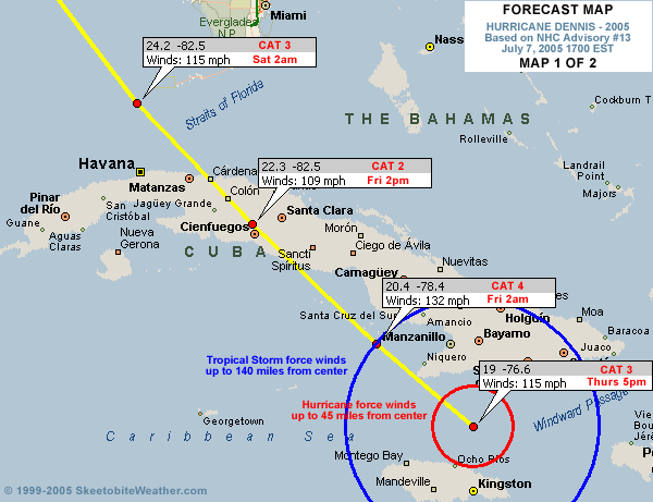
You can kind of see the ridge east of florida in this image. If it builds westward it could either force the storm more westward, or trap it to let it meander a bit and then escape to the Northeast. If it weakens or receeds, it would allow for more easterly movement. It's all speculation though. I'm not one of the Mets (Sky Blue names now!) so I'm out of my leauge on this talk.
Image here
|
twizted sizter
Weather Guru
Reged:
Posts: 184
|
|
If..if..it crosses key West...based on some of these model runs...Fl could be looking at 3 hits possibly...the keys, somewhere west central Fl, & then somewhere Panhandle.
Not wish/fearcasting...just making an observation.
|
Storm Hunter
Veteran Storm Chaser

Reged:
Posts: 1370
Loc: Panama City Beach, Fl.
|
|
20050707H1 Aircraft 42RF
Dennis flight 2005
The NOAA N43RF will fly a mission into Hurricane in conjunction with the NASA ER2 aircraft . The P3 will leave San Jose, Costa Rica at 11:00 PM EDT and will recover at San Jose at 8:00 AM EDT the next day.
NOAA and AF flight plans---- with NASA too
just in:
pressure down...eyewall reopened
URNT12 KNHC 072333
VORTEX DATA MESSAGE
A. 07/23:06:20Z
B. 19 deg 17 min N
077 deg 01 min W
C. 700 mb 2689 m
D. NA kt
E. NA deg nm
F. 324 deg 093 kt
G. 198 deg 009 nm
H. 951 mb
I. 11 C/ 3060 m
J. 17 C/ 3042 m
K. 12 C/ NA
L. OPEN SW
M. E36/20/16
N. 12345/ 7
O. 0.03 / 1 nm
P. AF304 0404A OB 31
MAX FL WIND 121 KT E QUAD 21:04:50 Z
--------------------
www.Stormhunter7.com ***see my flight into Hurricane Ike ***
Wx Data: KFLPANAM23 / CW8771
2012== 23/10/9/5 sys/strms/hurr/majh
|
richg
Verified CFHC User
Reged:
Posts: 10
Loc: Satellite Beach FL
|
|
From the previous thread: Here's an explanation of the -51C dewpoint in the RECCO:
97779 23074 51250 91100 88400 99005 78//8 /6973
RMK AF300 0604A OB 11
DEW POINT NEG 51C.
In re: to the 78//8 group:
TTTdTdw
TT is the temperature in Celsius. If the temperature is negative, 50 is added to the absolute value of the temperature, and any hundreds digits are omitted. For example, a temperature of -12 would be coded as 62 (12+50 = 62) To determine if a temperature of "10" is really +10 or -110, see the indicator number in the time group above. Missing temperatures are coded as //.
TdTd is the dewpoint at flight level. Dewpoints are encoded the same as temperature. When the dewpoint is colder than -49.4C, it is reported as // and a plain language remark is added with the actual dewpoint, i.e. DEW POINT M53C. // is also reported if the dewpoint is too dry to measure accurately, or missing.
|
Jeffmidtown
Weather Guru
Reged:
Posts: 132
Loc: Atlanta, Ga
|
|
The Weather Channel reports on the 8pm advisory ' pressure has dropped to 951mb and sustained winds are at 130mph....more to come
--------------------
You know it's a bad day.....when you wake up and see Jim Cantore and Geraldo Rivera broadcasting from your backyard....literally!
|
Southern4sure
Weather Guru

Reged:
Posts: 121
Loc: Land O Lakes, FL
|
|
Quote:
You can kind of see the ridge east of florida in this image. If it builds westward it could either force the storm more westward, or trap it to let it meander a bit and then escape to the Northeast. If it weakens or receeds, it would allow for more easterly movement. It's all speculation though. I'm not one of the Mets (Sky Blue names now!) so I'm out of my leauge on this talk.
Image here
Sorry to ask but what should I be looking for to barely see the ridge? I have studied this image and I cant make heads or tails.
Thanks!
|
Rich B
British Meteorologist
Reged:
Posts: 498
Loc: Gloucestershire, England, UK
|
|
Dennis does seem to be having a bit of difficulty in maintaining a closed eye, with the latest recon indicating that it is open to the SW, and also elongated. This could be due to interference / interaction with both the landmass of Jamaica, and the vicinity of southeast Cuba. Regardless, with pressure down and an earlier flight level wind of 139mph, i think will be approaching Cat4 within the next few hours. Despite his eye problems, he is a very well organised and structured hurricane.
--------------------
Rich B
SkyWarn UK
|
Brett
Weather Watcher
Reged:
Posts: 41
Loc: Miami, Florida
|
|
WOW..130? Rough. Big pressure drop. Earlier today I posted about the ULL...it could indeed be eroding the high to the east. This was my concern...
--------------------
South Florida
|
Colleen A.
Moderator

Reged:
Posts: 1432
Loc: Florida
|
|
I saw your earlier question about -51 degrees C. What that means (as Storm Hunter explained) is that it is cold. I think what it ALSO means is that the colder the clouds are, the stronger the storm.
Anyone feel free to correct me if this is not right. (I'm beginning to hate the word "right".)
--------------------
You know you're a hurricane freak when you wake up in the morning and hit "REFRESH" on CFHC instead of the Snooze Button.
|
Terra
Storm Tracker
Reged:
Posts: 286
Loc: Kingwood, Texas
|
|
Quote:
In re: to the 78//8 group:
TTTdTdw
TT is the temperature in Celsius. If the temperature is negative, 50 is added to the absolute value of the temperature, and any hundreds digits are omitted. For example, a temperature of -12 would be coded as 62 (12+50 = 62) To determine if a temperature of "10" is really +10 or -110, see the indicator number in the time group above.
That's a really weird convention... but, that still makes no sense.... -51 would be 51+50=101? Maybe I'm missing something?
--------------------
Terra Dassau Cahill
|
Southern4sure
Weather Guru
Reged:
Posts: 121
Loc: Land O Lakes, FL
|
|
Quote:
I saw your earlier question about -51 degrees C. What that means (as Storm Hunter explained) is that it is cold. I think what it ALSO means is that the colder the clouds are, the stronger the storm.
Anyone feel free to correct me if this is not right. (I'm beginning to hate the word "right".)
Thank you for putting it in words that I can understand.... 
|
Terra
Storm Tracker
Reged:
Posts: 286
Loc: Kingwood, Texas
|
|
A tiny bit more long movement over the last three hours than lat movement...
0.4 lat, 0.5 long...
--------------------
Terra Dassau Cahill
|
Brett
Weather Watcher
Reged:
Posts: 41
Loc: Miami, Florida
|
|
The 18Z is scary. Takes the storm nearly directly over Key West, and then up through to the panhandle at the Alabama border. Any mets out there care to comment on the terrain in Cuba affecting this powerful storm if it keeps chugging due NW? Doesn't it bode well for weakening?
--------------------
South Florida
|
G. J.
Weather Watcher

Reged:
Posts: 30
Loc: Tampa, FL
|
|
Will somebody be posting the figures tonight at midnight... I read on another thread that that's when the planes(or data from the planes?) will be in concerning how the trough will affect ' path.
By the way, since this is my first post, beers are on me 
|
Storm Hunter
Veteran Storm Chaser
Reged:
Posts: 1370
Loc: Panama City Beach, Fl.
|
|
http://uap-www.nrl.navy.mil/dynamics/html/er2.gif
here's a link to one of nasa ER2 aircraft..usually they fly really HIGH, above G4's i think.... a lot of research is being put into the storm.... flights today and friday will cover the whole GOM and east side of florida and around the storm....so i would expect tonight the models with today's dropsonde data would have a pretty good handle on the storm.
side note:
The NASA ER2 aircraft is flown solo at 20 km and carries a suite
of instruments similar to those on satellites. The CV-580 and ER2
were often operated simultaneously below the TERRA satellite and
above instrumented ground sites for validation of satellite measurements.
--------------------
www.Stormhunter7.com ***see my flight into Hurricane Ike ***
Wx Data: KFLPANAM23 / CW8771
2012== 23/10/9/5 sys/strms/hurr/majh
|
Southern4sure
Weather Guru
Reged:
Posts: 121
Loc: Land O Lakes, FL
|
|
Quote:
Will somebody be posting the figures tonight at midnight... I read on another thread that that's when the planes(or data from the planes?) will be in concerning how the trough will affect ' path.
By the way, since this is my first post, beers are on me
Im suppose to be going to a Hawiian party tomorrow night...guess it will turn into a hurricane party instead....cheers!
|


 Threaded