MikeC
Admin
Reged:
Posts: 4544
Loc: Orlando, FL
|
|
2:30am Update
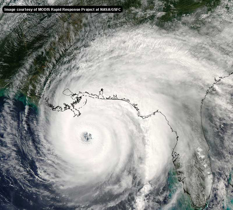
Recon reports indicate that the pressure has fallen to 950mb with Hurricane . A corresponding increase in winds, from the 110mph at the 2a advisory to major hurricane status, is likely forthcoming. The storm is projected to pass near or over the Loop Current, traditionally a region over which intense storms often deepen, meaning the potential is there for the storm to ramp up even further over the next couple of days. The current projected path takes the storm near New Orleans at landfall as a category 4 hurricane, a certainly unnerving scenario for many along the coastline. Stay tuned for updates on the highly uncertain future track of Hurricane .
Original Update
The National Hurricane Center has shifted the track westward tonight, in response to a general movement of the storm and the models.
It's now forecast to landfall along the Alabama coastline near Mobile County. This is a fairly substantial shift west from the Prior advisory, and it enlarges the cone of error.
The northern Gulf coast will want to watch . The Hurricane Center mentions the possibility of more adjustments to the forecast track later.

(We and are looking for feedback on maps, let us know here)
More to come as we get more information.
Event Related Links
General Links
Report conditions in your area/read other's reports at this link (registration not required).
StormCarib hurricane reports from observers in the Islands
Caribbean Island Weather Reports
Color Sat of Gulf
RAMSDIS high speed visible Floater of Storms
Emergency Management/County info
Gulf Coast Storm Alert Network
FloridaDisaster.org - Florida Emergency Management
Panhandle Coastal Counties West to East
Escambia County, FL, Santa Rosa, County, Okaloosa County, FL,
Walton County, FL,
Bay County, FL, Gulf County, FL, Franklin County, FL
Mississippi Emergency Management Agency (MEMA)
http://www.msema.org/index.htm
State of Florida Division of Emergency Management/floridadisaster.org
Katrina
 
Google Map plot of
Visible Floater Satellite of
Water Vapor Floater of
Visible Satellite Floater of with storm track overlays
Animated model plots of
Spaghetti Model Plot of from Colorado State
Florida Keys Long Range Radar Loop
Tampa, FL Long Range Radar
Tallahassee, FL Long Range Radar
Eglin Air Force Bace, Radar Panhandle
Mobile, AL Long Range Radar
Miami, FL Long Range Radar
Melbourne, FL Long Range Radar
Mobile, AL Long Range Radar
Forecast Discussions for (Show All Locations):
Miami, Key West, Talahassee, Mobile
Invest 97L

NRL-Monterey Satellite Data on 97L
METEOSAT-8 imagery over Europe & Africa from the Univ. of Wisconsin
Animated model plots of 97L
Edited by Clark (Sat Aug 27 2005 06:24 AM)
|
MissouriHurricane2008
Verified CFHC User

Reged:
Posts: 14
Loc: Missouri, USA
|
|
This storm the further west it tracks before turning North is not good, in my opinion. The Gulf waters are very warm and the longer the storm is out there the stronger it will get. I saw one model showing a 30% chance of this hurricane becoming a Cat. 5. The area from New Orleans to the Florida Panhandle needs to start preparing and watching very closely.
|
SirCane
Storm Tracker

Reged:
Posts: 249
Loc: Pensacola, FL
|
|
This is unreal. The can't seem to pinpoint the right spot which means you need to throw that line out the window and just follow the cone of uncertainty.
--------------------
Direct Hits:
Hurricane Erin (1995) 100 mph
Hurricane Opal (1995) 115 mph
Hurricane Ivan (2004) 130 mph
Hurricane Dennis (2005) 120 mph
http://www.hardcoreweather.com
|
Sheeper
Weather Hobbyist

Reged:
Posts: 62
Loc: Vero Beach, FL
|
|
The 1700 advisory expects 148MPH winds.
There was no impact to speak of here on the Treasure Coast. I took a Red Cross team thru St Lucie County today, even spoke to the EM folks. No flooding, nothing.
We did have some good 50MPH wind blasts last nite (got a shrub down) and some very heavy, intense but short lived rain.
Now we wait for the next thing out there.....
Support Your Red Cross Chapters!
--------------------
Emergency Management Consultant & Trainer
|
Clark
Meteorologist
Reged:
Posts: 1710
Loc:
|
|
Following the cone is quite the prudent thing to do. Truth is, we still have no clue as to where this storm is going right now, just based solely off of the spread in the guidance and how it keeps changing around, so everyone needs to watch this one closely. Truthfully, after a long day, that's about all I can say about it right now.
--------------------
Current Tropical Model Output Plots
(or view them on the main page for any active Atlantic storms!)
|
Miami Beach, FLA USA
Verified CFHC User
Reged:
Posts: 16
Loc: Miami Beach, FLA
|
|
Trust me, don't focus on a the line of "certainty", but the cone, we got slammed bad last night, after the storm that was supposed to cross the alley ended up coming down 95 into Dade County, the east side of the eye wall railed us for 6 hours....it looks like a war zone around Dade County, but nothing like Andrew...in terms of structural damage or roof damage
|
TDW
Weather Watcher
Reged:
Posts: 37
Loc: Mobile, AL
|
|
The biggest problem from a Monday landfall may be that a lot of people will spend the weekend having too much fun and not paying attention to the warnings. Then Monday rolls around and its too late.
--------------------
"It's time to see the world
It's time to kiss a girl
It's time to cross the wild meridian"
|
Storm Hunter
Veteran Storm Chaser

Reged:
Posts: 1370
Loc: Panama City Beach, Fl.
|
|
looking a radar/sat in last hour hr...i think is moving more west, maybe a jog to northwest now than south...not sure if it's just a jog or wobble... will see if the trend continues....of course its hard to tell...she is getting futher away from the radar....beam of radar is shooting higher up in storm....
also signs of an eye?
shaded region
--------------------
www.Stormhunter7.com ***see my flight into Hurricane Ike ***
Wx Data: KFLPANAM23 / CW8771
2012== 23/10/9/5 sys/strms/hurr/majh
Edited by Storm Hunter (Fri Aug 26 2005 09:30 PM)
|
twizted sizter
Weather Guru
Reged:
Posts: 184
|
|
and on the NOAA site if you look at the Mariners 123 rule the entire state is in the cone.
|
Rick on boat in Mobile
Weather Drama Guru

Reged:
Posts: 161
|
|
go to the key west radar....it'll show up for at least a few more hours...I think....
however...there won't be any radars in the middle of the Gulf....just a lot of fish souffle'
|
00cj
Weather Watcher
Reged:
Posts: 26
Loc: Panama City Beach, F.L.
|
|
I really hate it when the shifts the track that drastically because then it makes it harder to know for sure if it's correct. I also see what looks like a drift to the nw. Clark I was wondering if your thinking has changed with the system or not ?
|
MrSpock
Storm Tracker
Reged:
Posts: 296
|
|
I see what you are seeing. We'll have to see if this a wobble, or the start of a trend. For now, the 255 motion does not seem to be happening.
By the way, for radar, I use weathertap.com. It is about $70 per year, but is a great site for radars, lightning data, etc.
|
Big Kahuna
Weather Hobbyist

Reged:
Posts: 52
Loc: DeLand, Florida
|
|
Navy has 90L at 25kts and pressure at 1009mb 10N-35W. Does anybody have any more updated info?
|
Rich B
British Meteorologist
Reged:
Posts: 498
Loc: Gloucestershire, England, UK
|
|
Hey guys,
Katrina remains impressive on both radar and satellite, but is still struggling to close her eyewall to the north. If this happens, expect her to really get going, and there are indications this could be happening now. Visible imagery also continues to show a but no eye as yet. Has anyone noticed the really quite frightening thing with the current forecast track and intensity? If it plays out as currently forecast then will make landfall just to the west of Mobile bay. This means that Mobile Bay would be in the northeast quadrant of a landfalling major Hurricane piling up water from the ocean into the narrowing bay. A flooding nightmare!
--------------------
Rich B
SkyWarn UK
|
Ryan
Storm Tracker

Reged:
Posts: 281
Loc: Long Island, NY / Stuart, FL
|
|
if it follows the 5 PM track, it will go more toward Mobile area. I am thinking the track will shift a little bit more east beforer making the second landfall. As for intensity, i think it could and just may get up to cat. 4 status. The water is so warm down there. Its like putting fuel on a fire.
--------------------
2006 Atlantic Season Summary:
Bad, But Not AS Bad.
Life's a Storm, Watch Your Back
|
Margie
Senior Storm Chaser

Reged:
Posts: 1191
Loc: Twin Cities
|
|
Quote:
The 1700 advisory expects 148MPH winds.
No, it predicts 115kt (132mph) sustained winds. It said the superensemble model brings her up to 130kt (around 150mph) sustained winds before landfall.
Agreed that this was mentioned specifically because of its significance. However that wasn't a prediction.
You know what...130mph, 150mph; both are the same problem. Once you get above 130mph sustained, with higher gusts, does it really matter except for the record books. But let's be accurate about paraphrasing the .
--------------------
Katrina's Surge: http://www.wunderground.com/hurricane/Katrinas_surge_contents.asp
|
weatherwatcher2
Weather Hobbyist

Reged:
Posts: 97
Loc: Parrish florida
|
|
what a nightmare is right! do you agree with such a dramatic shift west?
|
TDW
Weather Watcher
Reged:
Posts: 37
Loc: Mobile, AL
|
|
Sitting in dowtown Mobile a couple hundred yards from the water, I know storm to our west is bad news. Even Georges flooded us pretty good. There is simply no where for the water to go as it moves up Mobile Bay.
--------------------
"It's time to see the world
It's time to kiss a girl
It's time to cross the wild meridian"
|
Rich B
British Meteorologist
Reged:
Posts: 498
Loc: Gloucestershire, England, UK
|
|
Well with the forecast models gradually coming into better agreement it certainly has more weight to the forecast. I dont think we will see a second landfall in Florida from . I do think we will see her landfall near or to the west of the current forecast track. I dont see any eastward shift likely.
--------------------
Rich B
SkyWarn UK
|
Rick on boat in Mobile
Weather Drama Guru

Reged:
Posts: 161
|
|
yet
|


 Threaded


