recmod
Weather Guru

Reged:
Posts: 188
Loc: Orlando, FL
|
|
Quote:
EDIT: With a pressure of 910, if my memory is correct, is now the 3rd strongest hurricane on record - only Camille (908?) and Gilbert (897?) had lower pressures. I'm using my memory so this may not be the case.
1980's Hurricane Allen peaked at 899mb
--Lou
|
DebbiePSL
Weather Guru
Reged:
Posts: 151
Loc: Saint Marys Georgia
|
|
I believe the Florida Keys hurricane was 892 mb not real sure but seems like I heard that mentioned 1) Florida Keys Cane 2) Camille 3)Andrew
|
SirCane
Storm Tracker

Reged:
Posts: 249
Loc: Pensacola, FL
|
|
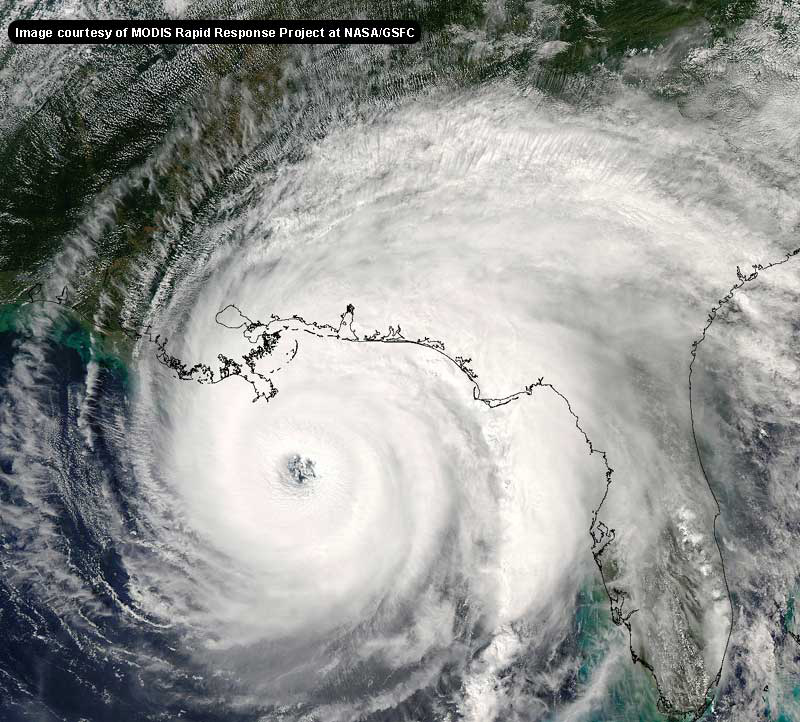
Just noticed the and UKMET models turn a little NE before landfall and turns it to the AL/MS line. Could that possibly happen? I know turned a bit NE before landfall. This thing freaks me out. This is like Andrew but like triple the size! 
908mb! Isn't that what Camille was??
--------------------
Direct Hits:
Hurricane Erin (1995) 100 mph
Hurricane Opal (1995) 115 mph
Hurricane Ivan (2004) 130 mph
Hurricane Dennis (2005) 120 mph
http://www.hardcoreweather.com
|
Kevin
Weather Master

Reged:
Posts: 524
Loc: EC Florida
|
|
910 millibars....crap...the last vortext message read 915. This is an absolutely horrific situation. There's no either way I can put it. There isn't going to be much left of New Orleans after this. Also, points east such as the coasts of Miss. and Alabama are also going to be severely impacted.
|
Margie
Senior Storm Chaser

Reged:
Posts: 1191
Loc: Twin Cities
|
|
Hahaha did you see the time on that recon. Just before the 615am advis. That's what they were waiting, on since the earlier recon data, before making it official.
--------------------
Katrina's Surge: http://www.wunderground.com/hurricane/Katrinas_surge_contents.asp
|
CaneTrackerInSoFl
Storm Tracker

Reged:
Posts: 395
Loc: Israel
|
|
Gilbert at 888 was the strongest on record.
Then the Labor Day Cane at 892.
Then Allen at 899.
--------------------
Andrew 1992, Irene 1999, Katrina 2005, Wilma 2005
|
jr928
Weather Guru
Reged:
Posts: 101
|
|
not seeing that, where is the url for it? the last models I saw continue to contradict each other as to ne or just n once landfall. That trough will either impact later today or it won't until it hits land and just has some westerlies impact.
The mayor gets an "F" on this one. Mandatory evac should have been much sooner. Who waits for a 5 to evac a city of 2 mill?
Edited by jr928 (Sun Aug 28 2005 12:03 PM)
|
WhitherWeather
Verified CFHC User
Reged:
Posts: 20
|
|
Sorry for the short content but it has now, rapidly, dropped to 908 MB.
WitherWeather
|
Domino
Weather Guru
Reged:
Posts: 191
Loc: Makati City, Philippines
|
|
I am watching the live feed from WWL 4 and they are now reporting 908mb. Strange being able to watch this live from Manila...
|
Margie
Senior Storm Chaser

Reged:
Posts: 1191
Loc: Twin Cities
|
|
Those are pressures at landfall . Many hurricanes have had low pressures out at sea.
--------------------
Katrina's Surge: http://www.wunderground.com/hurricane/Katrinas_surge_contents.asp
|
Margie
Senior Storm Chaser

Reged:
Posts: 1191
Loc: Twin Cities
|
|
Yeah the recon data for 908mb has already been posted automatically to this site - look in the upper LH corner.
--------------------
Katrina's Surge: http://www.wunderground.com/hurricane/Katrinas_surge_contents.asp
|
kissy
Verified CFHC User
Reged:
Posts: 20
Loc: Pascagoula, MS
|
|
Good morning all! Well down here in good old Pascagoula MS they have ordered a voluntary evacuation but not mandatory. Is there any possibility this thing would turn more east? Just curious what everyones thoughts were. Looks like also since it is a cat 5 we may be leaving. Have to board up the house and dh has to go and do something at the casino. (he works there).
Anyway, just want to say that this is a great site and I have gotten so much information! Thanks everyone!
--------------------
Nothing like fishing in the middle of a hurricane! Katrina '06!
|
Kevin
Weather Master

Reged:
Posts: 524
Loc: EC Florida
|
|
Quote:
I am watching the live feed from WWL 4 and they are now reporting 908mb. Strange being able to watch this live from Manila...
Absolutely shocking...the pressures in this storm are dropping like an absolute rock.
But...looking at those Gulf water temps...I actually had a very bad feeling about this earlier this year. Hurricanes are here, in part at least, to balance temperatures by transporting heat in the tropical regions to the temperate regions. And will do a good job of it, at the cost of the northern Gulf Coast.
|
jr928
Weather Guru
Reged:
Posts: 101
|
|
Jim Cantore on is casting doom all over the place. Boy he is serious this morning. He is warning people up to TN. I have not heard a report that turns ne or E as that trough has not impacted at all. You can see some good sats that show this at
http://www.geocities.com/tropicwx/
|
LI Phil
User

Reged:
Posts: 2637
Loc: Long Island (40.7N 73.6W)
|
|
Good morning all. remotely accessing the site as i am not a home, but will be later today...woke up this morning to a CAT V ...this is not good
i won't state anything obvious like anyone in her path had better be on their way out of here, but it is now more important than ever, for the future bullseye, to keep a keen eye on her track...100 miles either side will be impacted very strongly regardless of eventually landfall, and conditions on the coast will begin deteriorating very rapidly...
in past years we all talked about how CAT V's can sort of "create their own weather" and thus become less and less affected by climatology...while i don't believe this is necessarily true, huge monsters like this are still pretty rare so we don't exactly have all that much data to go upon...all i can see is be prepared for pretty much anything...
buckle up...again
--------------------
2005 Forecast: 14/7/4
BUCKLE UP!
"If your topic ain't tropic, your post will be toast"
|
errorcone
Registered User
Reged:
Posts: 6
|
|
Quote:
Just noticed the and UKMET models turn a little NE before landfall and turns it to the AL/MS line. Could that possibly happen? I know turned a bit NE before landfall. This thing freaks me out. This is like Andrew but like triple the size! 
908mb! Isn't that what Camille was??
This thing should freak you out. if you're in Pensacola.
There's been so much focus on NO and Biloxi. Pensacola is basically in the error cone. You should be focusing on that. If this thing hits say 15 miles W of Pensacola you don't need me to tell you how bad it could be.
If I were in Pensacola I would probably be boarded up and leaving today. But that's just me. I'd rather err on the side of living and safe as opposed to focusing on the line that we all know better then to focus on.
Edited by errorcone (Sun Aug 28 2005 12:13 PM)
|
Disaster Master
Weather Hobbyist

Reged:
Posts: 72
Loc: San Antonio G0! Spurs Go!
|
|
Wow. I went to sleep @ 2am. eastern. Look what i missed.As of now she's the 3rd lowest pressure on record. Mandatory Evacs @ 9:30am central time. PLEASE people EVACUATE.
FYI : As an Insurance Adjuster of 12 years i can tell you this.... Mandatory Evac. By Federal or Local Government triggersa what is called A.L.E. Additional Living Expenses. This will take care of most of the money you put out during your Evacuation. This coverage applies even if there is no damage to your home during the storm. This coverage will pay you back any moneys you spend beyond your normal routine.
It will pay for you hotel room wether its the Red Roof Inn, or the Ritz. There will be 50 a day perdiem for food with 20.00 per day extra per child. This is one of the most powerful storms ever in the gulf . With honors to Camille. Do not let money keep you from Evacuating, thats what pawn shops are for people. Your life and the lifes of your family are more important than any home you own or anything in it. 
Sorry for being dramatic. I havent had coffee yet. Its brewing Cheers!!
Edited by Disaster Master (Sun Aug 28 2005 12:12 PM)
|
Kevin
Weather Master

Reged:
Posts: 524
Loc: EC Florida
|
|
Agree about the inland impacts, Phil. This storm is much larger than Andrew, but it could be nearly as strong at landfall (possibly, I say). But it could sustain itself well inland...we could see hurricane force winds all the way up to northern MS and AL. Inland flooding will also be a major concern.
|
lunkerhunter
Storm Tracker

Reged:
Posts: 248
Loc: Saint Augustine, FL
|
|
I would guess Camille went <900mb since there was a full day of no data.
0 GMT 8/17/69 25.2N 87.2W 160 905 Category 5 Hurricane
6 GMT 8/17/69 26.0N 87.7W 180 -999 Category 5 Hurricane
12 GMT 8/17/69 27.0N 88.2W 185 -999 Category 5 Hurricane
18 GMT 8/17/69 28.3N 88.7W 190 -999 Category 5 Hurricane
0 GMT 8/18/69 29.4N 89.1W 190 909 Category 5 Hurricane
Keys was 892mb
0 GMT 9/ 3/35 24.5N 80.1W 160 892 Category 5 Hurricane
|
KATFIVE
Weather Watcher

Reged:
Posts: 25
|
|
I hesitate to drop the "c" bomb, but this thing is looking more and more like Camille. She bottomed out at 905 mb and hit 909 mb, although she was a bit smaller than KAT. What we have to concentrate on now is on factors, hopefully, that will ratchet this monster down a bit. Any mods or other hurrigeeks have info about SSTs, wind shears, or dry air ahead of this storm?
|


 Threaded


