Random Chaos
Weather Analyst

Reged:
Posts: 1024
Loc: Maryland
|
|
I & J: 1 C difference from inside to outside the eyewall.
M: no radiuses given???
----
410
URNT12 KNHC 190000
VORTEX DATA MESSAGE AL042007
A. 18/23:37:50Z
B. 16 deg 01 min N
070 deg 53 min W
C. 700 mb 2382 m
D. 102 kt
E. 011 deg 005 nm
F. 105 deg 118 kt
G. 013 deg 006 nm
H. EXTRAP 920 mb
I. 15 C/ 3047 m
J. 16 C/ 3024 m
K. 15 C/ NA
L. CLOSED
M. CO
N. 12345/ 7
O. 0.02 / 1 nm
P. AF302 0704A DEAN OB 06
MAX FL WIND 118 KT N QUAD 23:36:00 Z
SLP EXTRAP FROM 700 MB
MET ACCURACY 1NM
Edited by Random Chaos (Sun Aug 19 2007 12:09 AM)
|
Hugh
Senior Storm Chaser
Reged:
Posts: 1060
Loc: Okaloosa County, Florida
|
|
920mb is the lowest pressure so far measured in Dean, isn't it? It was down to 924 before, but it never got down to 920 or below, did it?
The only reason I can see that they haven't upped the winds yet is that the recon must still be out there taking measurements. Hard to believe that kind of pressure drop doesn't make the winds go up.
--------------------
Hugh
Eloise (1975) - Elena and several other near misses (1985) - Erin & Opal (1995) - Ivan (2004)
|
StrmTrckrMiami
Weather Guru

Reged:
Posts: 148
Loc: Manchester, NH
|
|
Quote:
Is it just me or does the CIMSS 200-700 MB Layer Analysis show that the upper-low has had a slight southwestwards movement today? I could see that if this low moves farther south, it could "pull" Dean northwestwards more than anticipated. Maybe this is where the is getting its solution. Speaking of the in the 2100Z discussion, the mentioned, "THERE COULD BE VERY UNCERTAIN DAYS AHEAD SINCE THE HAS HAD A VERY RELIABLE TRACK RECORD."
Link to 200-700 Layer Analysis Map: http://cimss.ssec.wisc.edu/tropic/real-time/atlantic/winds/wg8dlm6.html
Use buttons in the upper left hand corner to see the history of this past in three hour increments.
Just a question, what do those lines mean? Are those the troughs that Dean has to get through? If so, when he gets through the one he is on now, and goes twords cuba, it looks very likely that Florida may get hit, this is why I am asking, because I am not that experiences.
--------------------
Tracking Storms Since 2004
Miami, Cocoa, Fort Myers and Jacksonville
Currently Reside in New England
|
RedingtonBeachGuy
Moderator
Reged:
Posts: 342
Loc: St. Cloud, FL
|
|
"Low Content Posts: Please do not make single line posts containing no
content (ie, "cool" "hello", "I agree", or something else completely void of
meaning). Or general cheerleading, for example, if you think someone did a good job and have nothing else to add send them a PM, it works better for this. Otherwise posts like these just litter up the forums.
Remember, is not a Chat Room - it is a Niche topic-oriented site, so please attempt to stay 'on topic' by placing your posts in the proper Forum."
The attempt here is to avoid the use of one-line posts. is not a Chat Room, it is a site for Forum-oriented dialogue, so please use it that way.
Reviewing many of the posts over the past two days, most of the one-liners add nothing to the exchange of information. A lot of them ask questions that have already been answered elsewhere - sometimes more than once.
Before you ask a question, take the time to review some of the other Forums - odds are that it already has been answered. Use the PM feature to thank someone for their input. Personal information does not belong on this site - it just clutters it. Keep in mind that there is another Forum for asking questions of a more general weather nature - please use it when appropriate.
When you post a one-liner like "I think that its moving WSW" and you don't include anything else - like WHY you think this - its going to get deleted by the Moderators. Sometimes we let this stuff go, but when we start to receive a bunch of complaints from other site users - we attempt to resolve the problem.
Please help us by following the site rules - it makes the job of site moderation a lot easier ... and it provides for a more enjoyable experience for all of the site users.
Thanks for your help on this.
|
Random Chaos
Weather Analyst
Reged:
Posts: 1024
Loc: Maryland
|
|
No, it never hit 920 before.
What's odd is that they dropped extra dropsounds, including at least one in the eyewall, yet the surface pressure is extrapolated. I don't get this - they should have had a surface reading for pressure.
Second, there is no radius given on the eyewalls. What are they?
Third, we have a very low temperature differential between inside and outside the eyewall; this would indicate an is underway.
Fourth, pressure is down, but so is wind speed. Either they didn't get a good representation of the wind speed, or something is causing the windspeed to fall other than the pressure. Any ideas?
|
Hugh
Senior Storm Chaser
Reged:
Posts: 1060
Loc: Okaloosa County, Florida
|
|
WU recon page now reports the pressure is down to 918, but with the maximum measured surface winds at 115mph.
Some very odd numbers are coming out of the recon, at least to my thinking.
Edit @8:15pm CT... Pressure now down another millibar, to 917 according to WU report.
--------------------
Hugh
Eloise (1975) - Elena and several other near misses (1985) - Erin & Opal (1995) - Ivan (2004)
Edited by Hugh (Sun Aug 19 2007 01:16 AM)
|
Clark
Meteorologist
Reged:
Posts: 1710
Loc:
|
|
The recon vortex message was kinda incomplete, but here's what I think is going on based off of what they've sent back...
1) Eyewall replacement cycle (ERC) is not yet complete. That's a CO for concentric in the eye character bullet, not a C0 for circular (with no radius info).
2) Accordingly, the maximum surface winds aren't responding to that 920mb pressure. Note that the 918mb pressure referenced elsewhere is also an extrapolated value and comes from the aircraft and the SFMR instrument.
3) The is *almost* done given the small temperature differential between inside and outside the eye. This suggests that it is akin to sampling inside of the larger eye but separated by the remnants of the inner eyewall.
4) Assuming this completes soon, it will shortly be over the warm eddy in the central Caribbean, as seen via http://www.aoml.noaa.gov/phod/dataphod1/work/HHP/NEW/2007228ca.jpg. This spells trouble for the nighttime hours, particularly when coupled with the diurnal convective maximum. The only potentially negative factor would be flow over Hispaniola causing dry air intrusion into the storm, but I feel that Dean is far enough away from it plus has significant other inflow channels for this to not be a factor.
Simply put, I feel that once the cycle completes within the next hour or two, it will be just a matter of time before Dean becomes a category 5 hurricane.
--------------------
Current Tropical Model Output Plots
(or view them on the main page for any active Atlantic storms!)
|
weatherguy08
Weather Hobbyist
Reged:
Posts: 60
Loc: Miami, Fla.
|
|
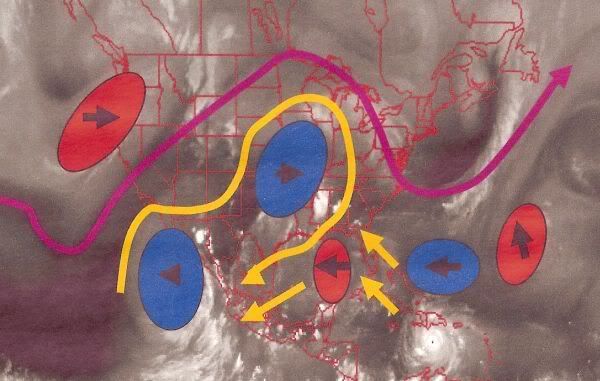
I saw that someone was wondering about the map on CIMSS I linked to earlier. Basically, the arrows show the flow in the atmosphere that will steer Dean. If you look at the hump over the western tip of Cuba, that is the upper-level low we have been talking about lately. The ridge is the large dip you can see that stretches from Charleston, SC to Barbados. This is pushing Dean to the west. The main situation is that if the ridge can push Dean fast enough, causing Dean to catch the upper-level low, Dean will move more northwards, but since as of now, Dean appears to be going about the same speed as the low, it does not look like Dean will catch it and the ridge will keep pushing him off to the west.
|
lunkerhunter
Storm Tracker

Reged:
Posts: 248
Loc: Saint Augustine, FL
|
|
can anyone access the CU CCAR Sea Surface height maps? I keep getting a server directory error.
|
Storm Hunter
Veteran Storm Chaser

Reged:
Posts: 1370
Loc: Panama City Beach, Fl.
|
|
hmm... looks like recon is inbound again.... interesting last vortex... At 00:48:00Z (last observation) from HDOB, the observation was 223 miles (359 km) to the SSW (192°) from Santo Domingo, Dominican Republic. They are flying to the NW.
*They just went throught the eye.. ** From the SE to the NW*** Highest wind i saw before next HDOB is out (will have eye penetration data) at 00:57:30Z at 15.72N 70.95W they are flying at (~ 20.56 inHg) 2,949 meters
(~ 9,675 feet) and had a flt. level wind of From 244° at 84 knots (From the WSW at ~ 96.6 mph)
--------------------
www.Stormhunter7.com ***see my flight into Hurricane Ike ***
Wx Data: KFLPANAM23 / CW8771
2012== 23/10/9/5 sys/strms/hurr/majh
Edited by Storm Hunter (Sun Aug 19 2007 01:07 AM)
|
dem05
User
Reged:
Posts: 368
Loc: Port Charlotte, FL
|
|
Post about 15-25 more minutes away...I don't mean to violate the forum here...I am only posting since I know that some of you have been waiting/expecting a post...It is coming, I promise. Still wrapping it up! Thanks! 
|
Ed in Va
Weather Master
Reged:
Posts: 489
Loc:
|
|
The models are now pretty tightly clustered, as the new has now come into line:
http://moe.met.fsu.edu/cgi-bin/gfdltc2.c...;hour=Animation
--------------------
Survived Carol and Edna '54 in Maine. Guess this kind of dates me!
|
Storm Hunter
Veteran Storm Chaser
Reged:
Posts: 1370
Loc: Panama City Beach, Fl.
|
|
Looks like pressure is down again... around 917-918mb.... winds seem to not have caught up
Stronger winds on the Outbound at 01:07:30Z near 16.13N 71.32W at alt. of 2,494 meters
(~ 8,182 feet) 932.2 mb(~ 27.53 inHg) Flt. lvl winds From 30° at 108 knots (From the NNE at ~ 124.2 mph)
--------------------
www.Stormhunter7.com ***see my flight into Hurricane Ike ***
Wx Data: KFLPANAM23 / CW8771
2012== 23/10/9/5 sys/strms/hurr/majh
|
Hugh
Senior Storm Chaser
Reged:
Posts: 1060
Loc: Okaloosa County, Florida
|
|
Quote:
Looks like pressure is down again... around 917-918mb.... winds seem to not have caught up
My guess is that they have not sampled the strongest winds. A 917MB pressure is well within the level that would justify an upgrade to Cat 5, though. Satellite presentation is not all that impressive, though... but then again, it has improved since 00Z (8pm ET), so we'll see if the plane can ever find stronger winds, and if not, what the does with Dean at 11pm.
Just saw the newest vortex - pressure *measured* at 918mb, but winds still only 123kts at flight level, which would be 111kts at the surface (~127mph).
--------------------
Hugh
Eloise (1975) - Elena and several other near misses (1985) - Erin & Opal (1995) - Ivan (2004)
Edited by Hugh (Sun Aug 19 2007 01:23 AM)
|
Nathan
Verified CFHC User
Reged:
Posts: 10
|
|
True on the coming into line with the rest of the models, but most of the models are now almost 7.5-8 hours old,
im still saying that I think the will move back and forth for a couple of days, but they do say it is one of the more reliable models. I think how is approaches the Yucatan is going to really give is a better idea of later in the week. The variables of the pressure systems will still be in play.
|
Random Chaos
Weather Analyst
Reged:
Posts: 1024
Loc: Maryland
|
|
New recon in:
270
URNT12 KNHC 190119
VORTEX DATA MESSAGE AL042007
A. 19/01:05:20Z
B. 16 deg 04 min N
071 deg 13 min W
C. 700 mb 2370 m
D. 100 kt
E. 138 deg 012 nm
F. 223 deg 105 kt
G. 126 deg 005 nm
H. 918 mb
I. 11 C/ 3048 m
J. 17 C/ 3029 m
K. 15 C/ NA
L. CLOSED
M. CO
N. 12345/ 7
O. 0.02 / 1 nm
P. AF302 0704A DEAN OB 12
MAX FL WIND 118 KT N QUAD 23:36:00 Z
MAX FL WIND OUTBOUND 123 KT NW QUAD 01:11:00
MAX FL WIND OUTBOUND IN OUTER EYEWALL
|
dem05
User
Reged:
Posts: 368
Loc: Port Charlotte, FL
|
|
Well…with reports that the more recent runs of the are falling in line with the other models…It is growing unquestionably harder to go against the models. The overall situation is setting up very similar to Gilbert in 1988, albeit Dean is stronger now than Gilbert was. In 1998, Hurricane Gilbert went directly up the spine of Jamaica. By some kind of miracle, missed to the north in 2005, and and were somehow able to wrap around the island with little affect…followed by a resumption of the previous forecast track. pulled another mystery in ’06. With absolutely no intention of offending folks in Jamaica what so ever, I may need to buy a book on the Voodoo religion if Dean misses the island and has little influence. Unfortunately, Jamaican’s continue to be under the gun and I really feel for them. Dean continues to be a beast as expected.
Need to get back on task and on target here. I would say with reasonable comfort that the eastern gulf is 85% out of the woods (Alabama/Miss border eastward), the central gulf is 65-70% out of the woods (Mississippi and Louisiana), and the western gulf (Texas and northern Mexico) will have to watch Dean until he is gone.
With all of that said, I was not looking for a major course change today as far as Dean’s forward motion. Since the ULL low over the GOMex is heading west, I was more curious to see if Dean was close enough to feel the ULL effects. Until early to mid afternoon, he certainly did with a degree heading of 290 degrees. To me this was a warning sign that Dean was close enough to feel the effects, and if this ULL stalls in 48+ hours…that that would be when the surprises that contradict the models might begin. I believe that if you are in the eastern Gulf, you will not be 105% out of the woods until Dean makes landfall in the Yucatan…If there is a surprise course correction between the Caymans and the Yucatan in the next 48-60hours…be careful and don’t let your guard totally down until then. In the Central Gulf, you will not be 105% safe until Dean is beyond 95W…Unfortunately, that is almost 4 days from now…Western Gulf, I’m growing more and more concerned for you all the time.
With all this said, my school of thought remains somewhat different that many of the posters and a bit rebellious toward the models (only because they also seem to vary somewhat widely on the evolution of mid latitude patters and the Jet Stream at the 500mb level). In the end, I may be seen as way too rebellious if nothing happens course change wise, but I would rather air on the rebellious side of caution for now in the event of some surprises. Frankly, I’m still a bit curious as to why the models see a similar tropical/subtropical evolution, but seem to have varying responses to mid-latitude features. I take the approach that each separate interaction in each model should have a separate result (I am talking about the interaction of weather features at various latitudes here).
Diving a little deeper, and looking at the maps, there is a ridge over the Baha Peninsula in Mexico…It is bucking back against the trough over the east pacific. While the trough over the east pacific has moved little today…and upper level low off of Oregon and Northern California has pushed eastward. I wonder if when the ULL moves further east, it will respond by providing a digging trough over Utah and Texas…which would head to the east. Many models show the dissipation of this ULL, interestingly, the does not…But the also goes with a more southern path for Dean. Huh??? Also, the ridge over the middle states continues to head east, as does the trough over the western Atlantic. The one caveat here is that the Upper Level Low over the Gulf has progged westward; the Upper level low on the eastern side of the ridge north of Dean is starting to pull north. This has allowed the ridge north of Dean to Expand. This is significant, because this ridge may begin to expand and strengthen now...Just another Monkey wrench…However, if the trough in the Pacific moves westward, the upper low in the Gulf will get pulled in just the same as the one in the Atlantic and/or the forward westward progression of the upper level low may slow down again.
I hope this helps everyone somewhat, I’ve been in a bit of a hurry this evening, but I promised a post.
|
JustMe
Weather Guru

Reged:
Posts: 128
Loc: Orlando, Florida
|
|
With the new recon will Jamica have a direct hit if it continues on the path now that it is on?
--------------------
I have survived Betsy Miss, Camille Miss., Andrew Fl, Charley Fl, Frances FL, Jeanne FL,
|
oil tracker
Registered User
Reged:
Posts: 8
|
|
Quote:
…Unfortunately, that is almost 4 days from now…Western Gulf, I’m growing more and more concerned for you all the time......
Right now all models are forecasting the same path for the next 6 days at least; and the models have been endorsed by the track. The point for us now is just the bizarre combination of a monster as dangerous as boring at the same time.
Not much to comment. However amazing animal.
A linear 4-5 Hurricane for 8 days landing in a Latam Country is useless both, for the catastrophic people who want a every year and also, for those that try to ignore all major events that don’t affect US.
It seems to me that UKM guys always make a good job. For oil followers, Cantarell production is higher than the entire GOM one.
|
Clark
Meteorologist
Reged:
Posts: 1710
Loc:
|
|
Quote:
New recon in:
...
They don't explicitly include eyewall radius information again, but from the locations of the wind maxima, we can infer that the two eyewalls have radii of 5nm and 12nm respectively, or 10mn and 24mn in diameter.
--------------------
Current Tropical Model Output Plots
(or view them on the main page for any active Atlantic storms!)
|


 Threaded


