danielw
Moderator

Reged:
Posts: 3526
Loc: Hattiesburg,MS (31.3N 89.3W)
|
|
I will attempt a graphical retraction of my earlier SST Warming post.
I have enhanced the images below.
For 2008. All SSTs above 27C are bright green in color.

For 2007 all SSTs above 27C are bright blue in color.

The 2007, 27C SSTs extended as far north as the 28N latitude line, In the Loop Current.
And this year they are no further than the 26N latitude line, in the Loop Current.
The SST temperature scale, on the graphics has changed since 2005.
|
Lamar-Plant City
Storm Tracker

Reged:
Posts: 388
Loc: Plant City, Florida
|
|
The Florida Straits DO look a bit warmer this year. It would be cool to see the area from the straits SE of those pictures as a comparison as well. Good catch on the scales. I had a feeling something was amiss as we have NOT had that much warm weather this spring to lead me to believe the Gulf is much warmer than usual. Didn't have a lot of really cold weather this winter either, so it balances out a little. Just for trivia, the beach water temps here in the Tampa area just crested the 70 degree F line this weekend (I guess that would be 21 degree C).
--------------------
If you don't like the weather, wait 5 minutes...
2023 Season Prediction: 17/6/2
|
Hurricane29
Weather Guru

Reged:
Posts: 148
Loc: Miami Florida
|
|
Wow the anomalies in the eastern atlantic are crazy!

Edited by danielw (Tue Apr 01 2008 07:36 PM)
|
danielw
Moderator
Reged:
Posts: 3526
Loc: Hattiesburg,MS (31.3N 89.3W)
|
|
Quote:
...Good catch on the scales. I had a feeling something was amiss as we have NOT had that much warm weather this spring to lead me to believe the Gulf is much warmer than usual...
Actually, I missed the change in the scales. Several of the other members reviewed my post and found the scales had changed. I enhanced the graphics that I had posted to reflect the changes.
I believe this is called Peer Review. 
(Also known as Check Your Data First.) 
|
danielw
Moderator
Reged:
Posts: 3526
Loc: Hattiesburg,MS (31.3N 89.3W)
|
|
The following are current SST enhancements from NOAA's AOML.
http://www.aoml.noaa.gov/phod/cyclone/data/go.html
Tropical Cyclone Heat Potential Loop

Depth 26.C Isotherm

Sea Height Anomaly

Sea Surface Temperature Loop

Images should update daily.
|
danielw
Moderator
Reged:
Posts: 3526
Loc: Hattiesburg,MS (31.3N 89.3W)
|
|
More from NOAA's AOML.
04APRIL2005
Larger Image

04APRIL2006
Larger Image

04APRIL2007
Larger Image

03APRIL2008
Larger Image

|
Hurricane29
Weather Guru
Reged:
Posts: 148
Loc: Miami Florida
|
|
They anomalies continue to get cool!The Hurricane heat content is a non issue across the atlantic.What might this all mean come this hurricane season we will find out.

Edited by danielw (Wed Apr 09 2008 01:09 AM)
|
danielw
Moderator
Reged:
Posts: 3526
Loc: Hattiesburg,MS (31.3N 89.3W)
|
|
Excerpt from the evening Tropical Weather Discussion from / TPC.
TROPICAL WEATHER DISCUSSION
NWS TPC/NATIONAL HURRICANE CENTER MIAMI FL
805 PM EDT THU APR 10 2008
BASED ON 1800 UTC SURFACE ANALYSIS AND SATELLITE IMAGERY THROUGH
2315 UTC.
ATLANTIC OCEAN E OF 40W...
OTHERWISE...AN ELONGATED MID- TO UPPER-LEVEL RIDGE EXTENDS FROM
W AFRICA TO JUST E OF THE LESSER ANTILLES...WITH AN AXIS RUNNING
FROM 20N06W TO 12N53W. ALTHOUGH CONVECTION HAS DECREASED OVER
THE TROPICAL ATLANTIC THE LAST FEW DAYS...THERE ARE AREAS OF
INTEREST WHICH HAVE EMERGED OVER THE LAST 24 HOURS. THE FIRST
IS A CONVECTIVE CLUSTER N OF THE ...WITH WHAT APPEARS TO BE
A MID-LEVEL CYCLONIC CIRCULATION CENTERED NEAR 5N18W MOVING W AT
15 TO 20 KT. THIS FEATURE COULD BE CONSIDERED ONE OF THE
SEASONS FIRST AFRICAN EASTERLY WAVES. THE SECOND FEATURE IS
ALONG ELONGATED SURFACE TROUGH OF NORTHEASTERLIES CONVERGING
WITH EASTERLIES BETWEEN 8N AND 10N BETWEEN 45W AND 50W. EARLIER
VISIBLE SATELLITE IMAGERY REVEALED A TIGHTLY-COILED LOW- TO
PERHAPS MID-LEVEL CIRCULATION IN THE ASSOCIATED CONVECTION NEAR
9N46W....THOUGH THE CONVECTION SINCE THAT TIME HAS COLLAPSED.
http://www.srh.noaa.gov/printable.php?pil=TWD&sid=AT&date=2008-04-10%2023:46:57

Earlier rainbow enhancement of the Wave at 1800Z or 2pm EDT Thursday. Center of the circulation, at that time is near the bright red area near the bottom, center of the graphic. Directly above the "A" in APR 10 08
Taken 48 hours prior to the above picture at 2 pm EDT Tuesday.
This would appear to indicate that the current wave, in the first picture of this post, could be wave number 3.

Edited by danielw (Fri Apr 11 2008 01:57 AM)
|
poopface
Unregistered
|
|
wow. kind of early for a wave like that to roll off africa.
|
Ed Dunham
Former Meteorologist & CFHC Forum Moderator (Ed Passed Away on May 14, 2017)
Reged:
Posts: 2565
Loc: Melbourne, FL
|
|
Latest images (12/12Z) indicate that it is all but gone - but another small wave is noted on the African continent near 7N 8E. Nothing impressive yet - the tropics remain quiet in the basin, but in three months I'm sure we'll see quite a different picture.
ED
|
cchsweatherman
Weather Watcher
Reged:
Posts: 34
|
|
Over the past several hours, it has become evident that a low-level circulation has developed along a trough producing heavy convection near Trinidad. Just watch the latest VIS/IR satellite imagery for yourself. Shear has been decreasing over and preceding the system and convection seems to be maintaining itself. Will have to watch this area, although any tropical development is unlikely to occur.
Here is the latest image.

http://flhurricane.com/cyclone/faq.php#rules
Image size and linking.
Comments?
Edited by danielw (Mon Apr 14 2008 03:09 AM)
|
welp
Unregistered
|
|
What do you guys think of the impressive features rolling off africa this early? Isnt this usually reserved for June. What does it mean 3 months from now.
|
cieldumort
Moderator

Reged:
Posts: 2426
Loc: Austin, Tx
|
|
Nothing much doing there now. Not only are SSTs still rather marginal for tropical development, but whatever lower-level reflection may have been ever-so-briefly trying to take hold is awash in a tempest of very strong upper-level winds. We're still a good 1-2 months before the MDR starts to become noticeably favorable for TC genesis. Until then, if anything were to pop, it would most likely be from a cut-off ULL that bores down to the surface and begins acquiring subtropical characteristics, and this usually takes a lot of time and even then conditions have to be so, so right.
|
Lamar-Plant City
Storm Tracker
Reged:
Posts: 388
Loc: Plant City, Florida
|
|
I am interested to see how last week's cold snap affected SSTs. I know the in-shore water temps have dropped at least 2 degrees after the 4 cold nights and 3 cool days we had. Also will be interesting to see how far out into the Gulf the cooler temps were effective.
--------------------
If you don't like the weather, wait 5 minutes...
2023 Season Prediction: 17/6/2
|
danielw
Moderator
Reged:
Posts: 3526
Loc: Hattiesburg,MS (31.3N 89.3W)
|
|
Ed has posted an update to the forecast in the Storm Forum.
His current analog year, if I read it right, would be 1985.
He lists 1985 as "quite similar to the current and expected pattern". With 1974,2000,1971,1950, and 1989 following respectively.
(Ed, I hope I got that last sentence right.)
Here are the quick run downs of what happened in 1985. More information is available at the NHC/ TPC website.
Ana-Near Bermuda and Sable Island
Bob- Naples/ Ft Myers to Vero Beach,Fl with landfall near Beaufort,SC
Claudette-Formed near the Mouth of the MS River. Moved east to SE GA Coast, near Cape Hatteras, Bermuda and near the Azores Islands.
Danny-Tropical Wave off of Africa, to near Grand Cayman Islands, to SE GOM, 24hr Intensification to Hurricane, with landfall near Cameron, LA
Elena-Cape Verde wave, 30 knots forward speed to Cuba to SE GOM, toward the NW-then East to the FL Big Bend area, back toward the WNW with landfall near Biloxi,MS. Labor Day weekend Headache of a storm.
At one time or another the Coast from Morgan City,LA to Sarasota,Fl was under a Hurricane Warning. Hence the "Headache Storm".
Fabian-Formed 300 nm South of San Juan,PR. Moved ENE into North Atlantic.
Gloria-Cape Verde Is. to Leeward Is. to the Bahamas to Outer Banks,NC to Western Long Is. NY
Henri-Formed NE of the Bahamas and moved NNE on a track similar to Gloria.
Isabel-Cape Verde wave. From N of Hispaniola to landfall near Savannah,GA.
Juan-Formed in Central GOM in late October.Landfall near Morgan City,LA to Mouth of the MS River to 2nd landfall east of Pensacola,FL
Kate-Mid November storm formed near Virgin Is., to near the SE Bahamas, to near Havana,Cuba, to a landfall near Mexico Beach, FL
Again... this is a quick summation of the tracks from their Archives. At some point during 1985 a Tropical system was threatening the U.S. from the upper Texas Coast to Long Island,N.Y.
Now that's a lot of real estate!! 
|
Hurricane29
Weather Guru
Reged:
Posts: 148
Loc: Miami Florida
|
|
These two images speak for themselves. The second image was issued this past Tuesday. SST were forecast to below normal and now they are forecast to be above average for much of MDR. In addition to this shear values are already expected to below normal, extremely below normal in some places.
April 13 SST forecast
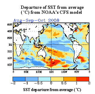
April 22 SST forecast
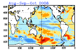
Edited by Hurricane29 (Sat Apr 26 2008 09:45 PM)
|
dr.hurricane
Unregistered
|
|
how can shear be forecasted?
|
Ed Dunham
Former Meteorologist & CFHC Forum Moderator (Ed Passed Away on May 14, 2017)
Reged:
Posts: 2565
Loc: Melbourne, FL
|
|
The short answer is that, in the long term, shear cannot be forecasted with any reasonable degree of accuracy. It can be implied from expected patterns, but those patterns, e.g. long waves, associated jet streams, etc., can themselves be wrong (and often are at the seasonal level). In the short term (up to three or four days) shear can be predicted with reasonable accuracy at the synoptic scale, but beyond that timeframe the accuracy and value of the forecast deteriorates rapidly. If a seasonal forecast for a region predicts high precipitation, the implication might be for more fronts and low pressure systems in that regon and therefore higher wind shear, but it doesn't always work out that way. Florida gets a lot of thunderstorms in the Summer (and therefore its a normal region of higher precipitation) but thats an expectation associated with temperature and seabreeze, i.e., climatology, rather than fronts and cyclones.
The SST forecast has changed (as noted in the Storm Forum) but all that really means is that the SST forecast for the Pacific regions that was made six months ago MAY no longer be accurate (keep in mind that the current forecast may also turn out to be inaccurate and the older forecast could still verify). The current forecast only suggests that any conclusions that may have been implied based on the earlier forecast should be revisited for potential revision.
I personally am not familiar with any accurate long term windshear forecasting technique.
Cheers,
ED
|
dr. hurricane
Unregistered
|
|
thanks for the answer. I fear if shear IS relaxed the season will be rough.
|
Hurricane29
Weather Guru
Reged:
Posts: 148
Loc: Miami Florida
|
|
CFS wind shear prediction anomalies:

Current Wind Shear Prediction Anomalies
Edited by danielw (Thu May 01 2008 12:04 AM)
|


 Threaded


