danielw
Moderator

Reged:
Posts: 3526
Loc: Hattiesburg,MS (31.3N 89.3W)
|
|
For a bit more information on a Hurricane with a track similar to Gustav's track.
Google Hurricane Betsy-1965 or Hurricane Pam, which was an exercise run against a hypothetical Hurricane called Pam.
Both Betsy and Pam had a SE to NW track near New Orleans.
Betsy left New Orleans in a huge mess. That's why the Levee System was built. At least one of the reasons.
|
MichaelA
Weather Analyst

Reged:
Posts: 950
Loc: Pinellas Park, FL
|
|
Long range Key West NWS radar shows the eye moving off the North coast of Cuba now. Looks intact.
--------------------
Michael
PWS
|
Beach
Weather Guru

Reged:
Posts: 187
Loc: Cocoa Beach/Banana River
|
|
Have you benn watching the winds in the keys.
Sand Keys:
Wind Direction (WDIR): E ( 100 deg true )
Wind Speed (WSPD): 47 kts
Wind Gust (GST): 50 kts
Atmospheric Pressure (PRES): 29.70 in
Pressure Tendency (PTDY): +0.00 in ( Steady )
Air Temperature (ATMP): 80.2 °F
Polaski Shoal:
Wind Direction (WDIR): E ( 80 deg true )
Wind Speed (WSPD): 40 kts
Wind Gust (GST): 47 kts
Atmospheric Pressure (PRES): 29.61 in
Pressure Tendency (PTDY): -0.05 in ( Falling )
Air Temperature (ATMP): 83.1 °F
Water Temperature (WTMP): 86.0 °F
Sombraro Key:
Wind Direction (WDIR): ESE ( 110 deg true )
Wind Speed (WSPD): 41 kts
Wind Gust (GST): 43 kts
Atmospheric Pressure (PRES): 29.72 in
Pressure Tendency (PTDY): +0.00 in ( Steady )
Air Temperature (ATMP): 79.9 °F
Salinity (SAL): 30.18 psu
Dew Point (DEWP): 76.8 °F
Tide (above MLLW) (TIDE): 2.47 ft
Heat Index (HEAT): 85.5 °F
Key West Radar:
http://radar.weather.gov/ridge/radar_lite.php?rid=amx&product=N0R&loop=yes
Latest from Habana Cuba:
Latest 9 PM (1) Aug 30 77 (25) 73 (23) 29.44 (0997) SE 31 heavy rain
Wind Direction (WDIR): E ( 100 deg true )
Wind Speed (WSPD): 47 kts
Wind Gust (GST): 50 kts
Atmospheric Pressure (PRES): 29.70 in
Pressure Tendency (PTDY): +0.00 in ( Steady )
Air Temperature (ATMP): 80.2 °F
|
mcgowanmc
Weather Hobbyist
Reged:
Posts: 96
Loc: NW ARKANSAS
|
|
Quote:
For a bit more information on a Hurricane with a track similar to Gustav's track.
Google Hurricane Betsy-1965 or Hurricane Pam, which was an exercise run against a hypothetical Hurricane called Pam.
Both Betsy and Pam had a SE to NW track near New Orleans.
Betsy left New Orleans in a huge mess. That's why the Levee System was built. At least one of the reasons.
I study the hydrology of MS River and it's tributaries up to Memphis. I'm familiar with the oil/gas structure
of the area as well as Chemical Alley stretching 30 miles to the West.
If CAT 4 Gustav dumps 26" North of Houma as it surges into Lake Pontchartrain, fill up your tanks.
Gas will be $5 by the next week.
|
madmumbler
Storm Tracker

Reged:
Posts: 324
Loc: SWFL
|
|
Quote:
It does appear that even with the wobbles Gustav had today, he is now clearly on a NW path...at quite a good clip, too. But we must also keep this in mind: this storm is HUGE...and will impact a lot of people, not just NOLA.
We've already got some pretty intense rain bands today here in w. Charlotte County (Fl). On top of all the water from TS Fay, there's going to be some inland flooding, most likely. Everyone needs to remember the impact isn't just wind and storm surge, it's rainfall. This system will dump a ton of water on an already saturated area, which will only compound the problems.
--------------------
Lesli in SWFL.
Friends help you move. Real friends help you move bodies.
|
Seminolestormwatcher
Registered User
Reged:
Posts: 1
Loc: Seminole,Florida
|
|
I sure hope the 11:00 pm advisory dosent move the cone any closer to florida. Gus sure does seem to have wobbled some to the north. Does anyone else think it is possible for this huge storm to have an effect on west-central Florida?
--------------------
Josh
Pinellas County
Elena(1985)
|
FIREREALTY
Registered User
Reged:
Posts: 8
Loc: BOCA RATON, FL
|
|
Well, if it does wobble to the east, and becomes a Fla. issue, there won't be much time to react with that big of a storm. I'm betting if they even had an outside chance that was to happen they'd have alrady metioned it. I've not seen anyhting at all on that even being a remote possibility. The closest I ever saw was one model putting it into Tallahassee area. I think we in Fla. will skate on this one with nothing but more rains-so much for the drought!! Hanna will be more rains too...so Lake Okeechobee will be back to regular height, its close now. And they said it'll be  years before we get enough rain to refill that thing...... years before we get enough rain to refill that thing......
|
StrmTrckrMiami
Weather Guru

Reged:
Posts: 148
Loc: Manchester, NH
|
|
Quote:
I sure hope the 11:00 pm advisory dosent move the cone any closer to florida. Gus sure does seem to have wobbled some to the north. Does anyone else think it is possible for this huge storm to have an effect on west-central Florida?
I would like to know the same thing.
If anything, I'm prepared for the power to go out..and so just in case the storm wobbles toward us, I'm Getting out!! I'm scared of Cat 5 hurricanes. Especially after ..
--------------------
Tracking Storms Since 2004
Miami, Cocoa, Fort Myers and Jacksonville
Currently Reside in New England
|
Thunderbird12
Meteorologist
Reged:
Posts: 644
Loc: Oklahoma
|
|
The latest forecast track looks about the same as before, though the most recent model guidance has nudged a little to the east, with many of the models indicating very little deviation from the current bearing before landfall. That would be bad news, but whether or not that is a trend remains to be seen. At this point, small changes in the bearing of the storm will make a big difference on the number of people potentially in the direct path of the storm. Stay tuned, as if anyone needs to be reminded of that.
Intensity-wise, it is hard to say what will happen, though the odds favor additional intensification at least over the southern Gulf. Outflow has been somewhat restricted on the southern side of the storm, but that seems to have improved during the day. Once it gets closer to the Gulf Coast, past history strongly suggests it will come down at least a little from peak intensity, but there is a good chance of a major hurricane at landfall.
|
Ronn
User

Reged:
Posts: 115
Loc: Seminole, FL
|
|
West-central Florida will experience rain bands and breezy conditions on Sunday and Monday, thanks to being on the eastern side of a large hurricane . A track slightly to the east of the current forecast track would elevate the rain and wind a little more than expected across the region; however, West-central Florida will likely escape any major impact from the storm. The rain bands should move quickly enough so that significant flooding is not a concern. Gustav is moving fast and everything points to landfall on the north-central Gulf coast. The consistency in the models has been remarkable.
|
vineyardsaker
Weather Guru

Reged:
Posts: 151
Loc: New Smyrna Beach, FL
|
|
I just listened to the press conference of Mayor Nagin. He speaks of the "mother of all storms", the "storm of the century" and of a storm whose power the cannot imagine. He ordered a complete evacuation of NO.
--------------------
Charley(eyewall), Ivan, Jeanne, Dennis, Wilma, Irma, Ian (eyewall), Nicole, Helene
|
danielw
Moderator
Reged:
Posts: 3526
Loc: Hattiesburg,MS (31.3N 89.3W)
|
|
They learned a lot 3 years ago. And he's trying hard not to make the same mistakes.
It appears that the New Governor, Bobby Jindal is on top of things too.
As soon as came out with a faster forward speed. Jindal moved up the time for ContraFlow to go into effect. It was 6 AM CDT, it now begins at 4 AM CDT and runs until at least Midnight Sunday Night.
HURRICANE WARNINGS WILL LIKELY BE REQUIRED FOR PORTIONS FOR THE
NORTHERN GULF COAST ON THE NEXT ADVISORY.
Gustav appears to be in an Eyewall Replacement Cycle- . As the Eye has disappeared from IR satellite imagery. If this is actually occuring Gustav would beginn to shrink the outer eyewall at approximately the same time that the storm is over the Loop Current. This could get very interesting. But remember. A storm can only hold a Cat 4 or Cat 5 level for so long. usually takes place within 24-36 hours.
Katrina was appeared to be starting an when she made landfall on the SE Louisiana Coast. and dry air entrainment contributed to a weakened at 1st Landfall.
For those that still own an AM radio. You can get up to the minute information from WWL-AM 870 on your radio. They should be receivable in most of the SE U.S.~danielw
Edited by danielw (Sun Aug 31 2008 12:14 AM)
|
cieldumort
Moderator

Reged:
Posts: 2426
Loc: Austin, Tx
|
|
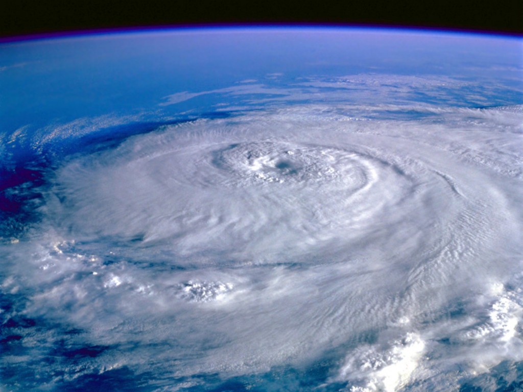
Strongly suspect that, much like Friday morning, Infrared is once again.. playing tricks.. on the eye. Radar still indicates just one very circular, very singular eyewal still pretty much intact. Being that Gustav is much more of a classic hurricane than the weirdness witnessed with Fay, there was some filling during the trek across Cuba, as the hurricane was cut off from the very warm waters it had grown quite accustomed to.
IR is truly the Houdini of all weather tools. We will have a more definitive answer to the question as to whether or not IR is actually tipping off an or not soon, as recon should start to get back in there by the top of the hour.
Radar out of Cuba does indicate that there isn't much precip falling in the bottom half of the cyclone, and that there could be a hint of a break in the southern portion of the eyewall. This will probably change once Gustav has spent 10-20 more hours in the Gulf. After that, there is some increased potential for shear to begin shoving in a little bit more dry air again.
|
typhoon_tip
Meteorologist
Reged:
Posts: 576
|
|
Quote:
They learned a lot 3 years ago. And he's trying hard not to make the same mistakes.
It appears that the New Governor, Bobby Jindal is on top of things too.
As soon as came out with a faster forward speed. Jindal moved up the time for ContraFlow to go into effect. It was 6 AM CDT, it now begins at 4 AM CDT and runs until at least Midnight Sunday Night.
HURRICANE WARNINGS WILL LIKELY BE REQUIRED FOR PORTIONS FOR THE
NORTHERN GULF COAST ON THE NEXT ADVISORY.
Gustav appears to be in an Eyewall Replacement Cycle- . As the Eye has disappeared from IR satellite imagery. If this is actually occuring Gustav would beginn to shrink the outer eyewall at approximately the same time that the storm is over the Loop Current. This could get very interesting. But remember. A storm can only hold a Cat 4 or Cat 5 level for so long. usually takes place within 24-36 hours.
Katrina was appeared to be starting an when she made landfall on the SE Louisiana Coast. and dry air entrainment contributed to a weakened at 1st Landfall.
For those that still own an AM radio. You can get up to the minute information from WWL-AM 870 on your radio. They should be receivable in most of the SE U.S.~danielw
There is no eye-wall replacement on-going at this hour. This does not typically take place for hurricanes in a disruptive phase of development. In fact, the current eye is in the process of redefining, after being temporarily disrupted by passing over the narrow land strip of western Cuba. I would not be surprised if we see a defined and circular eye with good clarity prior to even dawn on today (Sunday). If there is going to be an IR, it will probably happen during or just post passage over the huge heat content of the Loop Current. That is because the nearest outer rain bands will become hugely intense, and effectively choke off the inward flux to the core, such that an eye widens and the winds weaken. This [actually] may be the best case scenario for a Mississippi Delta landfall, because once hurricanes get into IR's, they don't tend to get "as strong" as they were during initial ramp up. Nevertheless, this doesn't look good... I have some trepidation at this our that Gustav may arrive in the northern Gulf slightly east of the current track guidance cluster, then "hook" west... That would be fantastically bad. In 1938, Narragansett Bay in RI took on a funneling of storm surge and that narrowing similar geography caused a nearly 30' foot rise in water levels. Here, we have those tuck waters on the northern side of the Delta; I really hope this either passes well enough west, or east, to spare a similar channeling of surge waters. As is modeled? Just about exactly wrong.
|
HanKFranK
User

Reged:
Posts: 1841
Loc: Graniteville, SC
|
|
first, a couple thoughts on gustav. folks in la got the message from the 2005 assault, and this time they're heading for higher ground. coastal louisiana is a deathtrap in a major hurricane. the eastern wards of new orleans are likely to be inundated again if the forecast track verifies, and a bit more deviation to the east and the chances that the city turns into a fishbowl again are enough to get people moving, hopefully. i don't think many people are dumb enough to stick around for that... the whole mass casualty event/humanitarian crisis from made an impression on even the thickest holdouts. gustav should sputter for a bit while its inner core recovers from that knot of hills in western cuba it just ripped across. the whole category five peak over the central gulf is as likely as not to occur, followed by a slow spin-down as the thermodynamic profiles for the storm decrease near the coast. the is definitely on the ball with this one... the devil is in the smaller scale track and intensity details. hope and pray that deviation to the left occurs in the track sooner than forecast, and that the storm moves ashore obliquely over less densely populated areas. i'm sure lafayette, new iberia, morgan city, houma, abbeville and the like have no reason to wish this on themselves... but the scale of the coming disaster can be governed by just 20 miles or so... or maybe one rung on the saffir-simpson scale.
further east hanna is plodding westward, making one of the more inconspicuous approaches that could be expected. gustav hype is letting this system slowly sneak up on the southeast coast... as forecast models have it slowly approaching throughout the new week. hanna probably won't change much in basic profile or location for the next three days... shear will keep shifting around, keeping the storm in check through mon-tue or so.. and forecast models are now showing a more amplified, less influential ridge, with a huge cut-off low off the canadian maritimes poised to set up shop early next week and slow hanna's approach. thereafter the ridge is shown breaking down more quickly, with the model solutions now edging hanna much further north than guidance had the storm just yesterday. what looked like an east florida threat now looks like a more typical jab at wilmington or cape lookout, then out to sea.. if the trends are to be bought. i'm not ready to buy anything... gustav is simple compared to hanna, in terms of forecasting. the exact evolution of the cut-off to the northeast (which will entrain energy from the active tropical waves further east), i'm suspicious about. if it amplifies that much, dips to new jersey latitude.. the sucker might just try a tropical transition. is it really going to eat away at the subtropical ridge north of hanna that much, or snatch harder at the sheared system trying to develop to the southeast? does hanna keep edging along westward or go quasi-stationary for two days near the east-central bahamas? this one is much harder to peg.
systems to the east--the feature tagged invest on the imagery, with no number... that one looks much better than the one just passing the cape verdes. shear or no shear, it has more going for it right now. there's an obvious surface center, which it seems fond of ejecting/reforming.. or reabsorbing.. and the shear is wheeling around more and appears to be slackening. when this thing gets to the edge of the subtropical ridge fracture, don't be surprised if it develops in earnest as it lifts out.
further east invest 97L is a large, sprawling wave... moving over marginal waters and unlikely to develop quickly. i'm not sure which model camp to buy into--some lift it through the ridge fracture just like the others... others, notably the euro, take it pretty much straight wnw for days. there are obvious disagreements on just how amplified the blocky pattern in the atlantic will get.
gfs is turning the faucet off after the following wave or two, indicating a lull, not seeing activity in the longer ranges. the atlantic goes back to a flatter ridge with no obvious breaks. scratching my head on that one--this time of year you need widespread westerly shear to stop development on that scale. guess we'll have to see.
HF 0553z31august
|
flanewscameraman
Weather Watcher
Reged:
Posts: 33
Loc: Palm Beach County, FLA
|
|
I am a news cameraman out of Miami, and just arrived in New Orleans..It is such a deja vu experience..I too hope for a slight left jog...Ths storm has the chance to do so much damage here, and after seeing what did coming in on the east side of the city, I am wondering what the end result may be with it coming in somewhat west...Any thoughts please let me know
|
flahurricane
Weather Hobbyist
Reged:
Posts: 55
Loc:
|
|
this isn't looking good at all....the slight jog to the right looks to bring the center directly over NO. I hope everyone gets out. I'm not sure what they will do with NO if this is a direct hit. He's a beast.
|
berrywr
Weather Analyst

Reged:
Posts: 387
Loc: Opelika, AL
|
|
Eyewall is being sheared at the moment, IR shows southern eyewall, but nothing else; CIMMS has 20 knots of southerly shear on top of him at the moment, but it is expected to lighten before returning H+24 hours.
--------------------
Sincerely,
Bill Berry
"Survived Trigonometry and Calculus I"
|
berrywr
Weather Analyst
Reged:
Posts: 387
Loc: Opelika, AL
|
|
According to the folks at LSU; 's track wasn't the perfect scenario to flood New Orleans; that track at present would require Gustav to make a very slight job to the "LEFT" and come in through Jefferson Parish and skim the Lake to the west. Reason is, on this approach; winds are from the southeast and then the east piling all that water in the Lake Ponchartrain; as the winds veer to west and all that water overtakes the southern shore and thus flooding New Orleans conventionally. Everybody has to remember NO did very, very good up against with the western flank eyewall just skiring the city which is the weaker side and weaker due to relative movement. If Gustav comes ashore west of the city; you can tack on the additional forward speed to the wind velocity on the east and south side. Right now, as of 0807Z, Gustav is right of forecast track and on a heading of 320 to 330.
--------------------
Sincerely,
Bill Berry
"Survived Trigonometry and Calculus I"
|
RedingtonBeachGuy
Moderator
Reged:
Posts: 342
Loc: St. Cloud, FL
|
|
While the intent of this site has always been and continues to be to provide a forum for serious tropical discussion, a spot where newbies are free to ask questions and mets and other experienced weather folks provide insight and information, there have recently been some complaints/questions etc..
There are hard and fast rules: ONE: NO CUSSIN'. Everyone is abiding by this, so no problem there; : No attackin'. We've had some minor as well as major activity in this area; the major ones have been sent to the graveyard...you know who you are and you should have probably surmised WHY your post has been deleted.
There are also a couple of "unwritten" rules the newer members may not be aware of, and perhaps need to be reiterated now. It might behoove some of the newer members to "go back" and read some of the discussion threads from 2004, particularly at the height of the "big four". We do NOT want to discourage anyone from posting, and everyone is certainly entitled to his/her opinion, it is STRONGLY recommended that long-timers and newbies alike to not "speculate" or "wishcast" about strength and landfall of future hurricanes, especially those that are not within 120 hours of any landfall. Such posts are irresponsible at best and could be dangerous at worst. If you feel you MUST predict a landfall and intensity, for example, at the very least be prepared to back up your prediction with some kind of science; if someone questions this, it had better not be in the form of a direct attack on the poster.
Finally, try to keep the "off-topic" posts to a minimum. Often a post which begins "on topic" can quickly get off topic.
I realize that people are justifiably on-edge. Lets all work together to keep the best and most informative hurricane site on the net. (originally posted by Phil in 2004)
|


 Threaded


