MikeC
Admin
Reged:
Posts: 4544
Loc: Orlando, FL
|
|
11:00PM CDT 25 August 2017 Update
Eye of Category 4 Harvey makes landfall between port aransas and Port O'Connor, TX. Early damage reports in Rockport, TX are extreme, an widespread. The eye is still slowly moving onshore, and the storm hasn't weakened yet.
Harvey's landfall on the Texas coast was over the northern end of San Jose Island about 4 miles east of Rockport.

6:00PM CDT 25 August 2017 Update
Recon has confirmed Category 4 winds in Harvey mere hours from landfall in the Middle Texas Coastline.

2:00PM CDT 25 August 2017 Update
Recon has found 120mph winds and a pressure of 943mb, making Harvey a major hurricane.
6:30AM CDT 25 August 2017 Update
Once landfall happens some models have it sitting inland near the coast until Monday, with potentially a second Texas landfall later in the week further north.
Recon continues to show pressure dropping, 946mb as of the latest pass. 951 with the latest dropsonde.
Those in the path of Harvey should have made preparations or evacuated if necessary yesterday. Those in the area check local national weather service and Media for more information for your particular area. There is a list of media on the main page of flhurricane.com below

12:30AM CDT 25 August 2017 Update
Recon has found that the more gradual lowering of barometric pressure and leveling off of wind that Harvey experienced yesterday may have come to an end, and the hurricane could be entering a new round of Rapid Intensification tonight.
Harvey remains forecast to become a high-end Cat 3 before landfall, but implicit in this is the possibility of Cat 4 between advisory times. Regardless of Category, it is very likely that Harvey will be a catastrophic hurricane on many levels, not the least of which will be the potential to produce biblical inland flooding over an extended duration, and possibly over extensive areas.
Efforts to protect life, loved ones and property along the coast and just inland should now be getting rushed to completion. Anyone who elects to stay behind may be unreachable by emergency services, and left to fend for themselves in what could very easily become nightmarish life-threatening conditions.
-Ciel
4:00PM CDT 24 August 2017 Update
Harvey still strengthening, and the Hurricane Warning has been extended northeast of Matagorda to Sargent Texas.
10:00AM CDT 24 August 2017 Update
Per :
Harvey has intensified quickly this morning, and is now forecast to be a major hurricane at landfall, bringing life-threatening storm surge, rainfall, and wind hazards to portions of the Texas coast
.
Preparations to protect life and property should be completed by tonight, as tropical-storm-force winds will first arrive in the
hurricane and storm surge warning areas on Friday.
A Storm Surge Warning is in effect for much of the Texas coast. Life-threatening storm surge flooding could reach heights of 6 to 10 feet above ground level at the coast between the north entrance of the Padre Island National Seashore and Sargent.
Life-threatening flooding is expected across much of the Texas coast from heavy rainfall of 12 to 20 inches, with isolated amounts as high as 30 inches, from Friday through early next week. Please refer to products from your local National Weather Service office and the NOAA Weather Prediction Center for more information on the flooding hazard.
8:45AM CDT 24 August 2017 Update
Aircraft recon found 984 pressure, and a 16 nautical mile wide closed eye in Harvey. It's deepening quickly and winds will increase shortly after. Expect a hurricane today, and possibly a major hurricane at landfall.
Times will generally be in Central time because of the location of Harvey.
6:45AM CDT 24 August 2017 Update
Recon measured a 985mb pressure in Harvey which indicates a Hurricane, it seems to be going under rapid intensification now, which means Harvey will likely become a major before landfall. Those in the hurricane warning area should rush preparations now, and listen to local officials/media for local details.
6:30AM CDT 24 August 2017 Update
Harvey has strengthened slightly overnight and Recon has found potentially stronger winds that indicate Harvey could strengthen more today, possibly a hurricane later tonight or tomorrow. With that in mind, some new warnings have been issued:
Storm surge will likely be an issue in parts of the Texas coastline, therefore a Storm Surge Warning has been issued for the Texas coast from Port Mansfield to San Luis Pass.
Additionally a Storm Surge Watch has been issued from Port Mansfield south to
the Mouth of the Rio Grande.
A Hurricane Warning has been issued for the Texas coast from Port
Mansfield to Matagorda.
A Tropical Storm Warning has been issued from north of Matagorda
to High Island Texas
A Tropical Storm Warning and a Hurricane Watch has been issued from
south of Port Mansfield to the Mouth of the Rio Grande.
10AM CDT 23 August 2017 Update
Based on Recon, harvey has regenerated in the Gulf of Mexico as a Tropical Depression. The official forecast takes Harvey in as a Hurricane near Madagorda Midday on Friday.
Because of this,
A Storm Surge Watch has been issued for the coast of Texas from Port Mansfield to High Island, which includes Corpus Christi.
North fo that, a A Hurricane Watch has been issued for the coast of Texas from north of Port Mansfield to San Luis Pass. (just south of Houston)
A Tropical Storm Watch has been issued for the coast of Texas from the Mouth of the Rio Grande to Port Mansfield and from north of San Luis Pass to High Island.
The government of Mexico has issued a Tropical Storm Watch for the coast of Mexico from Boca De Catan to the Mouth of the Rio Grande.
Harvey is expected to slowly move into Texas, bringing extended periods of surge and wind, and extreme amounts of rainfall, starting tomorrow morning into Midday. If you are in the warning area make preparations now, and be prepared to be under bad conditions for a while as it is expected for Harvey to stall out and possibly move back into the Gulf. If you are in the warning area time to look to local media and officials for more pertinent information.
Conditions are right so that it is a good possibility that Harvey becomes a Major hurricane before landfall, category 3 or higher. So please please take this seriously if you live in the hurricane warning area.
edit: Recon found 985mb, which is enough for hurricane strength.
10AM CDT 23 August 2017 Update
Harvey is expected to slowly increase in strength at first, but increase more rapidly as it approaches the coastline, the forecast takes it in slowly and Harvey could wind up being a major flooding events for parts of Texas, Louisiana, and Mississippi. The National Hurricane Center calls out the fact this first forecast may change once motion and trends have established, so everyone in the watch area should be watching this system, and preparing. It is expected be an intensifying hurricane at landfall, and may do so quickly once near land.
Things may change rapidly with Harvey, so keep watch closely if you are in the watch/warning area and listen to local officials and media for the best information for your particular area.
Mark Sudduth from Hurricanetrack.com is on his way to Texas for Harvey, follow him at www.hurricanetrack.com
Original Update
The remnants of Harvey are very likely to regenerate in the Gulf, in fact the National Hurricane Center gives it a near 100% chance for development within the next 48 hours.
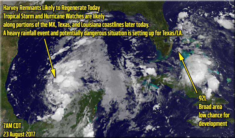
Those in northeastern Mexico to Louisiana should continue to monitor its progress as it could develop. Some models forecast it may landfall briefly then re-emerge into the Gulf, so those along the Gulf should monitor it even beyond the first landfall point. A strong Tropical storm or cat 1/2 hurricane is possible with the remnants of Harvey. if forward motion slows before landfall it could increase more than expected. Others suggest a single landfall, but slow moving, causing large amounts of rainfall,which ultimately may be Harvey's claim to fame.
Harvey's remnants have moved offshore and signs of an organized center are already occurring.
More information on Harvey remnants will come soon.
92L is currently a trough partially over Florida, but most of the rain is actually southwest of Florida this evening, it is not expected to develop into much, but could move back over Florida and develop in the Atlantic before heading out to sea, Worth Monitoring just in case something happens.
Harvey Related flhurricane recordings
|
Nick Humphrey
Meteorologist/Geographer

Reged:
Posts: 1
Loc: Lincoln,NE
|
|
I must say, for a system that hasn't even (re)developed yet, it's absolutely shocking to have such high degree of model agreement on scenarios. Somewhat equivalent to multiple independent medical tests giving you the same bad news. It certainly appear incredible amounts of rain may be the biggest story with the system. Obviously if the system drifts into LA, so does the torrential rain threat.

The heaviest total forecast rainfall from the latest 00Z would be for Houston. However, as some may heave heard, even "lighter" heavy rain in New Orleans could be disastrous given their recent drainage problems.
With all that said, I do have some concerns about the actual intensity as well. Temps in the Gulf head of Harvey are running in the mid-80s and with much lighter shear than it is initially facing now.

I think it is realistic for it to quickly become a hurricane if develops an organized inner core quickly. Given trends (as of tonight) I am hopeful advisories are started very soon to get the alert out as the Texas Coast is also very surge prone...beyond wind damage problems.
|
MikeC
Admin
Reged:
Posts: 4544
Loc: Orlando, FL
|
|
The models runs are interesting on Harvey this morning, go see the Forecast Lounge for that.
Recon is out in the system currently and finding it a very wet area, and it may be upgraded this morning.
|
MikeC
Admin
Reged:
Posts: 4544
Loc: Orlando, FL
|
|
Recon found the closed circulation, advisories are very likely now at 10AM CDT (11AM EDT)
|
MikeC
Admin
Reged:
Posts: 4544
Loc: Orlando, FL
|
|
I want to point out the first forecast map after regeneration may be a little off until motion and trends are established. Those in the watch area need to start preparing now, if this slows down as expected, it may have more time to strengthen, or at the very least cause extended periods of time with heavy rain and wind.
|
cieldumort
Moderator

Reged:
Posts: 2305
Loc: Austin, Tx
|
|
First-ever operational Storm Surge Watch

|
MikeC
Admin
Reged:
Posts: 4544
Loc: Orlando, FL
|
|
3 recon planes are investigating Harvey this evening.
|
MikeC
Admin
Reged:
Posts: 4544
Loc: Orlando, FL
|
|
Recon isn't finding much in the way of lower pressures, so it's likely the storm will stay a depression at 11PM, tomorrow afternoon is when things may improve, especially if the center of the system becomes a bit more circular that it currently is. Battle of two ridges east and west leaves the gap of low steering currents, which one wins out determines if it goes more west or east (or dragged back into the Gulf)
The LLC may be a bit exposed tonight.
|
cieldumort
Moderator
Reged:
Posts: 2305
Loc: Austin, Tx
|
|
Internal processes and some external wind shear has kept intensity in check throughout the day Wednesday, but that may be changing. Recon and satellite data indicates that Harvey is strengthening tonight. With water temps in the GOM exceptionally warm, and shear increasingly more favorable, Harvey will likely have a mostly conducive environment for strengthening up through landfall, or maybe more than one, as indicted by some models.
Wind at recon flight level of about 2,400' elevation in the northeast quadrant is now running at or above 50 knots. Taken together with some reliable SFMR estimates of at least 35 knots at the surface, Harvey has become a tropical storm again.
|
MikeC
Admin
Reged:
Posts: 4544
Loc: Orlando, FL
|
|
Recon measured a 985mb pressure in Harvey which indicates a Hurricane, it seems to be going under rapid intensification now, which means Harvey will likely become a major before landfall. Those in the hurricane warning area should rush preparations now, and listen to local officials/media for local details.
|
cieldumort
Moderator
Reged:
Posts: 2305
Loc: Austin, Tx
|
|
Went to bed late last night telling friends that I am at a 40% chance Harvey becomes a Major, with Harvey at 1001mb, and just woke up to recon just finding 985mb. This is the type of tropical cyclone we are looking at here, folks.
Watch to see how well Harvey develops an inner core over the next 24 hours. If Harvey generates a solid inner core, which appears to be underway, his environment - ocean heat content, wind shear, humidity, etc. -> all very conducive for several phases of Rapid Intensification, and Harvey could become our first landfalling Major Hurricane since 11 years ago.
|
MikeC
Admin
Reged:
Posts: 4544
Loc: Orlando, FL
|
|
Aircraft recon found 984 pressure, and a 16 nautical mile wide closed eye in Harvey. It's deepening quickly and winds will increase shortly after. Expect a hurricane today, and possibly a major hurricane at landfall.
Times will generally be in Central time because of the location of Harvey.
|
cieldumort
Moderator
Reged:
Posts: 2305
Loc: Austin, Tx
|
|
Just a reminder, with Harvey undergoing RI and quite possibly becoming our first landfalling Major in over a decade, the Second Main Event is getting lost a bit in the media cycle.
To be plain, Harvey is likely going to be a high-end inland hurricane for longer than people realize, and only slowly weaken, wind-wise. What may not weaken much, if at all, will be Harvey's potential to create biblical rainfall, as the well-developed cyclone travels through a 'Brown Ocean,' that is Texas this year, and possibly tracks very slowly and/or stalls altogether and/or has one or more reemergence over the Gulf - Rainfall totals over wide areas may exceed 12", with localized totals possible in this set-up exceeding three feet. Three feet. This would likely result in several locations of severe, record-setting flooding, and countless other locations of major flooding.
For people well inland
>>> People living in any of Texas' most flood-prone locations that are within the entire cone of uncertainty should now be preparing to evacuate. Evacuating by Saturday, rather than waiting for the waters to block exits or come rushing to the front door, can save lives.
>>> People who live in portions of the state who only experience even rarely dangerous flooding, this means you should be paying very close attention, and at least consider evacuating by Saturday if you live within Harvey's entire cone of uncertainty.
>>> People who live within Harvey's core cone (and closer to the eyewall's expected track), who live in mobile homes or traditional structures but that are not sound, should begin planning to evacuate as well, especially so should Harvey become a major, which looks increasingly likely. An inland only slowly decaying Major Hurricane Harvey in this set-up could easily produce wind gusts in excess of 80MPH well inland, and possibly for an extended duration. Winds this strong can rip, flip or even destroy most mobile homes, and some traditional homes that are not structurally sound.
As always, these are personal opinions only. Please refer to your local NWS for official information.
The above time-tables are not my thoughts for people living right along, or closer to the coast, who would be wise to have evacuated by tomorrow morning.
Edited by cieldumort (Thu Aug 24 2017 05:59 PM)
|
MikeC
Admin
Reged:
Posts: 4544
Loc: Orlando, FL
|
|
Pressure now down to 981.5, winds have not caught up to the pressure drops yet.
|
MikeC
Admin
Reged:
Posts: 4544
Loc: Orlando, FL
|
|
Started to record Corpus Christi Radar
http://flhurricane.com/imageanimator.php?264
Other recording will pop up as it nears.
|
Psyber
Storm Tracker

Reged:
Posts: 231
Loc: Ontario, Canada
|
|
Sorry cieldumort, but I wanted to verify how the storm surge is being calculated now? Is it using a straight ESTIMATION of the surge or does it include NOAA buoy information as well? With or without, since Harvey is going to be spinning up so quickly, I'm predicting less storm surge as it'll have less time really push the surf.
That's one thing that doesn't seem to be included enough in almost every forum is plotting using direct NOAA buoy data. I'd love to be able to have every 5 square miles by 5 square miles calculations because it'd add a whole ton of tracking information.
Once you saw it hop over the Yucatan with those SST's and lack of sheer you could see it was going to really spin up.
The latest of 980mb barometer is going to make it a time version anything keeping it out to sea which isn't much at this point. Thankfully not enough to create a large a gigantic wind/storm surge field.
Does anyone think that the is really protecting the movement to drop awfully fast once it hits land? If so it's going to drop an ungodly amount of rain(I see this more dangerous than storm surge) if mid to high-level sheer stalls once it lands. 
--------------------
The safest way to deal with a potential Hurricane hitting you...is to leave and just not be there at all.
|
cieldumort
Moderator
Reged:
Posts: 2305
Loc: Austin, Tx
|
|
Quote:
Sorry cieldumort, but I wanted to verify how the storm surge is being calculated now? Is it using a straight ESTIMATION of the surge or does it include NOAA buoy information as well? With or without, since Harvey is going to be spinning up so quickly, I'm predicting less storm surge as it'll have less time really push the surf. How is storm surge observed and measured?
From (May not answer your question, which is probably best directed to @NHC)
Quote:
"Storm surge is water from the ocean that is pushed onshore by the force of the winds. Flooding from storm surge depends on many factors, such as the track, intensity, size, and forward speed of the tropical cyclone and the characteristics of the coastline where it comes ashore or passes nearby. These factors are difficult to predict far in advance of a tropical cyclone affecting a particular area."
Tide Stations (NOAA): A network of 175 long-term, continuously operating water level stations throughout the U.S. serving as the foundation for NOAA's tide prediction products and providing data for storm surge estimates.
Storm Surge Tide Station
NOAA Tide Station
Measure still water (e.g., no waves)
Traditionally most reliable
Limited stations
FEMA/USGS High Water Marks (HWM): These marks are lines found on trees and other structures marking the highest elevation (peak) of the water surface for a flood event created by foam, seed, or other debris. Survey crews are deployed after a storm to locate and record reliable HWMs. GPS methods are used to determine location for coastal HWMs, which are then mapped relative to a vertical reference datum such as NAVD88.
Storm Surge High Water
High Water Marks Inside A Building
Perishable
Traditionally best method for capturing highest surge
Subjective and often include impacts of waves
Pressure Sensors (USGS): These are temporary water-level and barometric-pressure sensors which provide information about storm surge duration, times of surge arrival/retreat, and maximum depths.
Storm Surge Pressure Sensor
USGS Pressure Sensor
Relatively new method
Deployed in advance of storms at expected location of highest surge
Can contain impacts of waves
With regard to Harvey's potential storm surge, it could have the potential to be greater than you'd expect, because the system will be drawing in the ocean for a long time - even once well inland.
|
MikeC
Admin
Reged:
Posts: 4544
Loc: Orlando, FL
|
|
Recon has it down to 977mb, still strengthening fairly rapidly.
|
danielw
Moderator

Reged:
Posts: 3525
Loc: Hattiesburg,MS (31.3N 89.3W)
|
|
Storm Surge is currently being forecast at 8 feet to 12 feet. By . Depending on the location and slope of the coastal shelf and beachfront.
Mainly dependent upon minimum central pressure (MCP) of the storm. Other factors are Moon Phases with Full Moon and New Moon having larger tides.
The tides are Outside of the calculation,
In other words. Landfall at High tide under a New Moon or Full Moon will add roughly 1-2 feet to the Surge. Not including the Storm Waves.
Rough quick estimation formula.
1000mb - minus current MCP 977 divided by 4 equals current minimum surge.
1000-977=23/4 equals a minimum 5.75 foot surge with out Tide or waves.
If you are under a Surge Watch or Warning Heed advisories and Get Out NOW while you can before the Roads become Clogged.
Edited by danielw (Thu Aug 24 2017 08:54 PM)
|
MikeC
Admin
Reged:
Posts: 4544
Loc: Orlando, FL
|
|
Most recent recon pass down to 969mb, strengthening leveled off a few hours ago, seems to be back on the trend, although probably not rapid this evening (This may change tomorrow)
|


 Threaded


