F
Current Radar or Satellite Image

Flhurricane.com - Central Florida Hurricane Center - Tracking Storms since 1995Hurricanes Without the Hype! Since 1995


The 2024 Atlantic Hurricane Season Begins on June 1st and lasts until Nov 30th. NHC Outlooks resume on May 15th..
Days since last H. Landfall - US: Any 236 (Idalia) , Major: 236 (Idalia) Florida - Any: 236 (Idalia) Major: 236 (Idalia)


Archives 2020s >> 2022 News Talkbacks

Pages: 1
cieldumort
Moderator


Reged:
Posts: 2305
Loc: Austin, Tx
Potential Tropical Cyclone One (Alex) and Invest 92L
      #114115 - Thu Jun 02 2022 08:46 PM


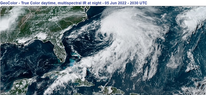
Above: Tropical Storm Alex and Invest 92L June 5, 2022 2030z

5:00PM EDT 05 June 2022 Updated
Alex is now a strong western Atlantic Tropical Storm with maximum sustained winds at the surface estimated to be 65MPH. Recon continues flights into the cyclone on its approach to Bermuda tonight to get a closer look.


12:00PM EDT 05 June 2022 Update
PTC1 sufficiently organized overnight and became Tropical Storm Alex. The cyclone has so far continued to intensify today, with maximum sustained surface winds as of this update estimated to be a possibly conservative 60 MPH.

Alex is headed towards Bermuda first, before becoming Post-Tropical further out at sea, and Tropical Storm Warnings are up for Bermuda, where the greatest impact should be felt later tonight into Monday. Hurricane-force gusts on the island are very possible.


3:30PM EDT 03 June 2022 Update
The center of sprawling PTC One appears to be leaping a bit as it chases the deeper convection that is being sheared to the northeast. The number one threat from One will continue to be from moderate to very heavy rain, much of it falling over the same locations, leading to flooding.

Elsewhere, we are also tracking newly Invest-tagged 92L, located west-southeast of Bermuda.

5AM EDT 03 June 2022 Update
Recon overnight found that PTC One has become better organized, with lower pressure, and slightly stronger wind, but was unable to conclusively determine that a more stable and closed low level circulation center has formed.

Because of the sprawling nature of this system and the finding of tropical storm winds at the surface, NHC has issued additional Tropical Storm Warnings, now including the east coast of Florida, western Cuba, and the northwestern Bahamas.

Daylight visible satellite imagery and another recon pass will help determine if a Tropical Cyclone has formed.

Original Entry
Invest 91L does not yet meet the criteria for designation as a Tropical Cyclone. However, as it is organized enough and highly likely to become a bona fide TC, NHC is starting Advisories on Potential Tropical Cyclone One, with tropical storm conditions anticipated within 48 hours along its path.

PTC One is expected to be a prolific rainmaker, and flooding could become serious especially where there is training. In addition, there looks to be a good risk of waterspouts and tornadoes, some moving very fast, some others also at night. Warning lead times on such tornadoes can be brief, and within heavy precip can be especially difficult to see coming. Flood Watches/Warnings and Tornado Watches/Warnings will likely also be forthcoming.

Join us for more analysis and model talk on ALEX in the Tropical Storm Alex Forecast Lounge


Northeast Gulf Links <html><a href="http://radar.weather.gov/ridge/Conus/southeast_lite_loop.php" onMouseover="ddrivetip('<img src=\'http://radar.weather.gov/ridge/Conus/Loop/southeast_loop.gif\'>');" onMouseout="hideddrivetip();">Southeast Composite Radar Loop</A>

(<a href="http://radar.weather.gov/ridge/Conus/southeast_lite.php" 

onMouseover="ddrivetip('<img src=\'http://radar.weather.gov/ridge/Conus/RadarImg/southeast.gif\>');" onMouseout="hideddrivetip();">Latest Static</a></html>)

<html> <a href="https://radar.weather.gov/ridge/lite/K</html>TBW<html>_loop.gif" onMouseover="ddrivetip('<img src=\'https://radar.weather.gov/ridge/lite/K</html>TBW<html>_loop.gif\'>');" onMouseout="hideddrivetip();"></html>Tampa Bay, FL Radar<html> Radar Loop</A>

(<a href="https://radar.weather.gov/ridge/lite/K</html>TBW<html>_0.gif" onMouseover="ddrivetip('<img src=\'https://radar.weather.gov/ridge/lite/K</html>TBW<html>_0.gif\'>');" onMouseout="hideddrivetip();">Latest Static</a>)</html>

<html> <a href="https://radar.weather.gov/ridge/lite/K</html>BYX<html>_loop.gif" onMouseover="ddrivetip('<img src=\'https://radar.weather.gov/ridge/lite/K</html>BYX<html>_loop.gif\'>');" onMouseout="hideddrivetip();"></html>Key West, FL Radar<html> Radar Loop</A>

(<a href="https://radar.weather.gov/ridge/lite/K</html>BYX<html>_0.gif" onMouseover="ddrivetip('<img src=\'https://radar.weather.gov/ridge/lite/K</html>BYX<html>_0.gif\'>');" onMouseout="hideddrivetip();">Latest Static</a>)</html>

<html> <a href="https://radar.weather.gov/ridge/lite/K</html>MOB<html>_loop.gif" onMouseover="ddrivetip('<img src=\'https://radar.weather.gov/ridge/lite/K</html>MOB<html>_loop.gif\'>');" onMouseout="hideddrivetip();"></html>Mobile, AL Radar<html> Radar Loop</A>

(<a href="https://radar.weather.gov/ridge/lite/K</html>MOB<html>_0.gif" onMouseover="ddrivetip('<img src=\'https://radar.weather.gov/ridge/lite/K</html>MOB<html>_0.gif\'>');" onMouseout="hideddrivetip();">Latest Static</a>)</html>

<html> <a href="https://radar.weather.gov/ridge/lite/K</html>TLH<html>_loop.gif" onMouseover="ddrivetip('<img src=\'https://radar.weather.gov/ridge/lite/K</html>TLH<html>_loop.gif\'>');" onMouseout="hideddrivetip();"></html>Tallahassee FL Radar<html> Radar Loop</A>

(<a href="https://radar.weather.gov/ridge/lite/K</html>TLH<html>_0.gif" onMouseover="ddrivetip('<img src=\'https://radar.weather.gov/ridge/lite/K</html>TLH<html>_0.gif\'>');" onMouseout="hideddrivetip();">Latest Static</a>)</html>

<html> <a href="https://radar.weather.gov/ridge/lite/K</html>EVX<html>_loop.gif" onMouseover="ddrivetip('<img src=\'https://radar.weather.gov/ridge/lite/K</html>EVX<html>_loop.gif\'>');" onMouseout="hideddrivetip();"></html>Northwest Florida Radar<html> Radar Loop</A>

(<a href="https://radar.weather.gov/ridge/lite/K</html>EVX<html>_0.gif" onMouseover="ddrivetip('<img src=\'https://radar.weather.gov/ridge/lite/K</html>EVX<html>_0.gif\'>');" onMouseout="hideddrivetip();">Latest Static</a>)</html>

Gulf of Mexico Satellite Imagery

SFWMD Full Florida Radar (Includes east LA, MS,AL) Loop with Storm Track

Area Forecast Discussions: New Orleans - Mississippi/Alabama/Pensacola - Panhandle/Tallahassee - Tampa/West Central Florida


Edited by MikeC (Tue Jun 14 2022 05:35 PM)


Post Extras: Print Post   Remind Me!   Notify Moderator  
scottsvb
Weather Master


Reged:
Posts: 1184
Loc: fl
Re: Potential Tropical Cyclone One [Re: cieldumort]
      #114116 - Fri Jun 03 2022 02:33 AM

Straight forward early season predictable forecast of 40-50mph storm.. mostly far east of the center due to shear.. Mostly rain 4-6 inches. winds generally 20-25mph.. bit more near open areas and water,,, few isolated tornados around Naples-Ft Myers and east coast. Storm will pick up spead later Friday and get across the state by mid day saturday.

Post Extras: Print Post   Remind Me!   Notify Moderator  
Pages: 1


Extra information
0 registered and 0 anonymous users are browsing this forum.

Moderator:  

Print Topic

Forum Permissions
      You cannot start new topics
      You cannot reply to topics
      HTML is disabled
      UBBCode is enabled

Rating:
Topic views: 6643

Rate this topic

Jump to

Note: This is NOT an official page. It is run by weather hobbyists and should not be used as a replacement for official sources. 
CFHC's main servers are currently located at
Hostdime.com in Orlando, FL.
Image Server Network thanks to Mike Potts and Amazon Web Services. If you have static file hosting space that allows dns aliasing contact us to help out! Some Maps Provided by:
Great thanks to all who donated and everyone who uses the site as well. Site designed for 800x600+ resolution
When in doubt, take the word of the National Hurricane Center