cieldumort
Moderator

Reged:
Posts: 2305
Loc: Austin, Tx
|
|
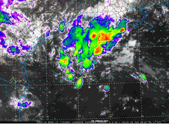
A low to mid-level shortwave interacting with the tail end of a cold front while being fanned by an upper level low is starting to show signs of slow development in the western Gulf of Mexico.
This feature has been forecast for several days with some lukewarm model support, and now that the disturbance exists and confirming what models were advertising, has just been Invest tagged, 95L, and we are starting a lounge on it at this time.
Invest 95L is over very warm Gulf waters and while experiencing some shear, as mentioned, the winds are also helping to fire up more convection on its otherwise sparsely decorated circulation, particularly west to north of the center, where the trof is also interacting with the sagging front. This is juicing up the atmosphere and aiding the front/mid-level shortwave interaction to develop a Low at the surface.
These are very 'home grown' Tropical Cyclogenesis ingredients coming together, and although formation is not certain, has increased its odds to 30% as of this morning's 2AM , and that could be conservative. The Atlantic basin as a whole right now is unusually perky for the month of June, with disturbances 'wanting' to develop.
Intensity - Models have been tepid on 95L's intensity, generally keeping it at or below minimum Tropical Storm force, at best. However, now that it has started to come together, these may be conservative, and there have been a number of outlier ensemble members that are more aggressive. This could especially be realized if 95L spends more time over water, which is looking increasingly plausible.
Track - Models have favored a continued track to the west-southwest or south-west near or into deep South Texas, and then diverge from a track inland more into Mexico, or a track inland through east Texas, or a grazing almost all coastal Texas eventually pushing in somewhere near the TX/LA border.
Hopefully recon will investigate 95L by tomorrow. The data hunters provide is invaluable.
|
cieldumort
Moderator
Reged:
Posts: 2305
Loc: Austin, Tx
|
|
As ultimately largely forecast, Invest 95L pushed inland upper TX coast/SW Louisiana on Friday July 1st, producing T.D.-like weather, with plenty of heavy rain and some flooding. Does not appear to have been a candidate for post-season consideration, unlike Invests 90L and 92L, which strong arguments can and have already been made.
--------------------
Fully vaccinated as of May 2021
(Moderna x2)
|
|


 Threaded


