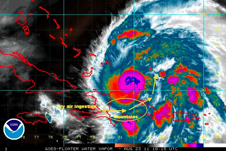
Irene keeps firing up deep convection over the core. Every time it starts to die down, new deep convection appears on IR, showing that the storm is still quite healthy even with the dry air entrainment from the affects of the mountains of Hispanola. This entrainment is very clear and will take some time to work out; probably will not fully work out until the storm is further from the mountains. We may see a lapse in storm growth until then, giving us at least several more hours of respite from additional strengthening.
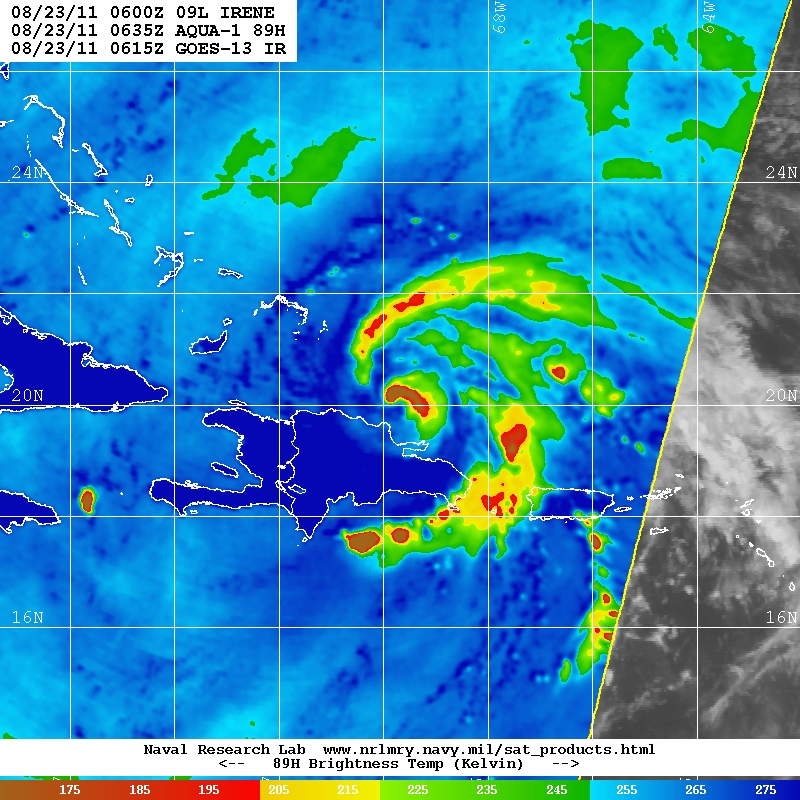
I also included a microwave pass from Modis (via NRL) which shows the outer convective band skirting around the south side of Hispanola in order to avoid the land and mountains. The eye is clearly disrupted, as seen in that pass. While several hours old, the storm has not changed much in IR appearance since then.
What one can see in the attached Water Vapor image is how the mountains are causing dry air ingestion into the storm. South of the mountains is a line of moderate to deep convection spiraling around to the right and north of the storm just outside the dry air stream caused by the land interaction. The storm is able to generate plenty of convection, but the land is keeping the system weaker than it would otherwise be.
The 00Z model runs are out, and converge more closely on a hit somewhere in the Carolinas. However, I want to bring special attention to the 00Z GFS run because it highlights why no one should stop paying attention to the storm. There is no guarentee that the 00Z GFS run is accurate, but it's a warning of what could be. That run shows the track strafing Florida, Georgia, and South Carolina into a North Carolina landfall, across the southern Chesapeake Bay, back out to sea, strafing the New Jersey coast, then back inland over Long Island and Massachusetts, possibly reemerging off the coast only to again make landfall in Maine. The potential exists that the entire Atlantic Seaboard will have significant effect.
This is only what one model run shows, but no one should ignore this storm.
0 registered and 104 anonymous users are browsing this forum.
Moderator:
Forum Permissions
You cannot start new topics
You cannot reply to topics
HTML is disabled
UBBCode is enabled
Rating:
Thread views: 28545
Note: This is NOT an official page. It is run by weather hobbyists and should not be used as a replacement for official sources.
CFHC's main servers are currently located at Hostdime.com in Orlando, FL.
Image Server Network thanks to Mike Potts and Amazon Web Services. If you have static file hosting space that allows dns aliasing contact us to help out! Some Maps Provided by:
Great thanks to all who donated and everyone who uses the site as well.
Site designed for 800x600+ resolution
When in doubt, take the word of the National Hurricane Center