
The large and sprawling Central American Gyre now has two main areas of enhanced/enhancing vorticity associated with it. First, newly-tagged Invest 91L that is attempting to consolidate and build down towards the surface in the southwestern Bay of Campeche (SW Gulf of Mexico), and Invest 90E on the Eastern Pacific side that has moved inland over Central America and is currently being absorbed by the parent Gyre.
NHC odds are now up to 70% within 48 hours that Invest 91L becomes a bona fide tropical cyclone in the western Gulf. There is a lot of potential for this system to create regional and localized significant and life-threatening flooding with several days of rains and thunderstorms, regardless of development.
Elsewhere, well east of the Bahamas the weak non-tropical low that has developed on the tail-end of an old front and residuals of old 90L still has has a fair chance of becoming a subtropical or tropical cyclone before crossing back over Florida and/or the southeastern US in a few days.
-Ciel
91L Event Related Links
https://flhurricane.com/images/2024/float91latest.gif https://flhurricane.com/images/2024/stormplotthumb_91.gif
SFWMD Model Plot (Animated Model Plot) SFWMD Hurricane Page
[https://flhurricane.com/floatanimator.php?year=2024&storm=91 Flhurricane Satellite Floater Animation of Invest 91L
GOES Floater
Animated Skeetobite Model Plot of Invest 91L
Clark Evans Track Model Plot of Invest 91L
(Animated!) Model Plots in Google Earth - In Google Maps
Clark Evans Intensity Model Plot of Invest 91L (Animated!)
Clark Evans Track Plot of Invest 91L
Clark Evans Top 10 Analog Storms for Invest 91L
More model runs on from RAL/Jonathan Vigh's page
NRL Info on Invest 91L -- RAMMB Info
COD Atlantic Satellite View
8AM 16 June 2024 Update
The area in the Atlantic is now up to a 30% chance for development, with the area highlighted from all of the east coast of Florida into Georgia currently. This likely will be a fast moving rain maker for wherever it makes landfall, and just to the right of that. Likely as early as Thursday.
The area in the gulf is about 60% chance and also most likely a flooding rain maker (albeit a slower moving one than the Atlantic) for Northern Mexico and Parts of Southeastern Texas.
Both should be continued to watch this week.
Original Update
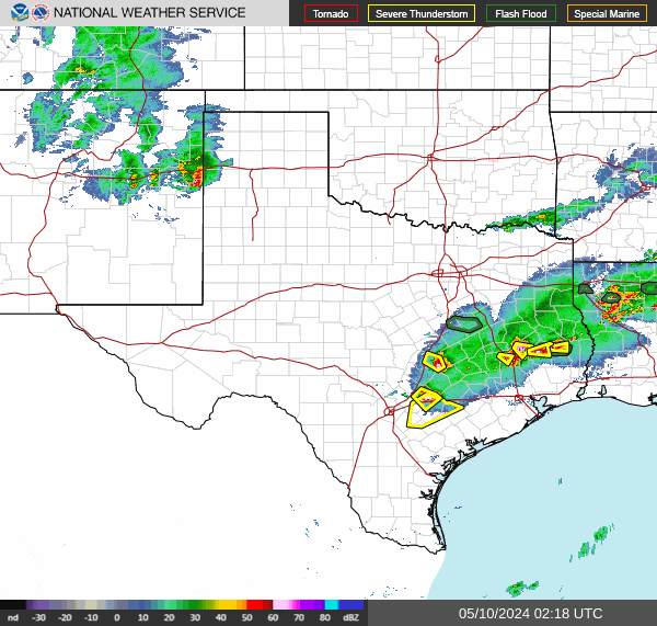
There are two areas of Interest currently, one area in the gulf now has a 60% chance to develop, and this Gulf area is likely not to get too strong, however it could dump flooding rains over Mexico and parts of Texas, including San Antonio and Austin.
The new area is 20% east of the Bahamas and could arrive to Florida or Georgia by Thursday later this week.
This system would arrive mid to late week (Thursday-Friday) before anything would happen there, and moving quickly so time is likely to keep it weaker, and bring some rain (but rain likely won't linger as long).
Texas Gulf Coast Links [http://moe.met.fsu.edu/~mnissenbaum/radar.html Mark Nissenbaum's radar page}
Texas Composite Radar Loop (Latest Static) East to West:
Houston/Galveston, TX Radar Radar Loop (Latest Static)
Corpus Christi, TX Radar Radar Loop (Latest Static)
Brownsville, TX Radar Radar Loop (Latest Static)
Gulf of Mexico Satellite Imagery
Area Forecast Discussions: Houston/Galveston, TX - Corpus Christi, TX - Browsnville/South Padre Island, TX
East Florida Links Southeast Composite Radar Loop (Latest Static) South to North:
Key West, FL Radar Radar Loop (Latest Static)
Miami, FL Radar Radar Loop (Latest Static)
Melbourne, FL Radar Radar Loop (Latest Static)
Jacksonville, FL Radar Radar Loop (Latest Static)
Caribbean/South East Coast Satellite Imagery
SFWMD Radar Loop of South Florida with storm Track
SFWMD Full Florida Radar Loop with Storm Track
Area Forecast Discussions:
FLorida Keys -
Miami/South Florida -
Melbourne/East Central Florida -
Jacksonville/Northeast Florida -
The 2024 Atlantic Hurricane Season Begins on June 1st
Posted: 12:33 AM 07 April 2024 | 3 Comments | Add Comment | Newest: 06:59 PM 14-Jun EDT
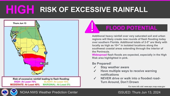
The center of Invest 90L may be pulling away from Florida, but the deep tropical fetch and Central American Gyre that helped create it are still very much in place. Locations in South Florida particularly remain at HIGH RISK today for life-threatening flash flooding.
From NWS WPC
Quote:
A HIGH RISK of Excessive Rainfall is now in effect across parts of South Florida (including the Miami metro region) as additional rounds of heavy rain are likely today over very sensitive locations still recovering from yesterday's flooding. Stay weather aware!
Recon is flying two missions this week. The first, an unassigned presently about the Yucatan. Tomorrow, into 90L off the east coast. Today's scheduled flight into 90L was cancelled.
The active June pattern continues.
-Ciel
2PM EDT Update 8 June
Over the past few decades, once a year or two on average a named storm forms in June in the western Atlantic. Early season activity is not necessarily a harbinger of an active season overall, but suffice it to say, nearly all professional forecasts are now calling for an above average to record setting season and pre-peak development would not surprise.
While most ferocious hurricanes tend to form and threaten during peak months of August through October, even sloppy "weak" tropical cyclones (Depressions and Tropical Storms) can wreak havoc, usually due to excessive rainfall and subsequent flooding.
We are now starting to pay close attention to a developing Central American Gyre in the western Atlantic. These features are fairly common this time of year for that region, but sometimes they can create and/or enhance favorable conditions for tropical cyclone formation that then nearly always impacts land. Even without TC genesis, these broad parental areas of low pressure frequently generate ongoing and often heavy rains.
The GFS operational and many of its ensemble members have been sniffing out a TC developing out of this CAG soup and spinning up close to Florida on or about the 15th (Forecast Lounge discussion).There has been some back and forth on this model's forecast intensity, but a few other models and/or their ensemble members are now coming more on board with this idea and providing some better consensus that development may occur close to home, and we will be paying close attention.
While things are still quiet, now would be a great time to gather up the essentials and create plans for potential power loss, flooding and the like.
-Ciel
Original Update
The 2024 Atlantic Hurricane Season begins on June 1st, 2024. The National Hurricane Center will resume outlooks a few weeks ahead of that, however, beginning May 15th, the Tropical Weather Outlooks will resume.
Here are the list of names for 2024:
| Alberto | Helene | Oscar |
| Beryl | Isaac | Patty |
| Chris | Joyce | Rafael |
| Debby | Kirk | Sara |
| Ernesto | Leslie | Tony |
| Francine | Milton | Valerie |
| Gordon | Nadine | William |
2024: Alberto, Beryl, Chris, Debby, Ernesto, Francine, Gordon, Helene, Isaac, Joyce, Kirk, Leslie, Milton, Nadine, Oscar, Patty, Rafael, Sara, Tony, Valerie, William
The last time this list of names was used was in 2018, of the names from 2018 Milton replaced Michael on the list, which was a category 5 hurricane that made landfall near Mexico Beach, FL on October 10, 2018. And Francine replaced Florence that made landfall near Wrightsville Beach, North Carolina on September 14th, 2018.
If we use up all the names for 2024, then the National hurricane center will start to use the Alternate naming list, which is
Alternate name list: Adria, Braylen, Caridad, Deshawn, Emery, Foster, Gemma, Heath, Isla, Jacobus, Kenzie, Lucio, Makayla, Nolan, Orlanda, Pax, Ronin, Sophie, Tayshaun, Viviana, Will
With la nina likely, this year is more probable for a high number of systems, and the prevailing patterns also suggest they will be further west, with more toward the west Atlantic than last year. Some of the numbers for the season are much higher than usual, including Colorado State which is projecting 23 named storms (more than they have ever projected before in April). So this year in particular is one to watch out for more impacts than last year, which had a lot of activity, but most of it stayed away from land. Idalia being the biggest one last year for Florida.
Flhurricane is moved to a different server this year, but the late 90s look is still here. Some of the backend was updated along with the server (newer versions, etc) but the site is mostly unchanged.


