
Watches and Warnings To Begin on Storm 01L in the W Gulf
Posted: 08:22 PM 17 June 2024 | | Add Comment
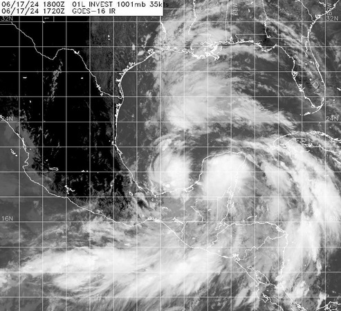
Watches and Warnings are now going up for the Invest in the Bay of Campeche that is already producing sustained winds into tropical storm force and likely to become a bona fide Tropical Cyclone prior to landfall. The first name on the list this year is Alberto.
Quote:
Potential Tropical Cyclone One Advisory Number 1
NWS National Hurricane Center Miami FL AL012024
400 PM CDT Mon Jun 17 2024
...LOW PRESSURE AREA OVER THE BAY OF CAMPECHE EXPECTED TO BRING
HEAVY RAINFALL THREAT TO PARTS OF THE WESTERN GULF COAST...
...TROPICAL STORM WATCH ISSUED FOR PARTS OF THE COAST OF TEXAS AND
NORTHEASTERN MEXICO...
SUMMARY OF 400 PM CDT...2100 UTC...INFORMATION
----------------------------------------------
LOCATION...20.3N 93.2W
ABOUT 380 MI...615 KM SE OF LA PESCA MEXICO
ABOUT 470 MI...755 KM SE OF BROWNSVILLE TEXAS
MAXIMUM SUSTAINED WINDS...40 MPH...65 KM/H
PRESENT MOVEMENT...NNW OR 345 DEGREES AT 7 MPH...11 KM/H
MINIMUM CENTRAL PRESSURE...1001 MB...29.56 INCHES
WATCHES AND WARNINGS
--------------------
CHANGES WITH THIS ADVISORY:
A Tropical Storm Watch has been issued for the Texas coast from Port O'Connor southward to the mouth of the Rio Grande.
The government of Mexico has issued a Tropical Storm Watch for the northeastern coast of Mexico south of the mouth of the Rio Grande to Boca de Catan.
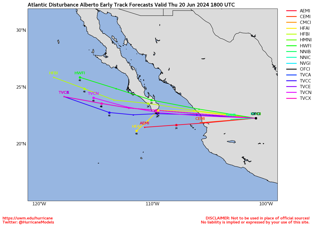
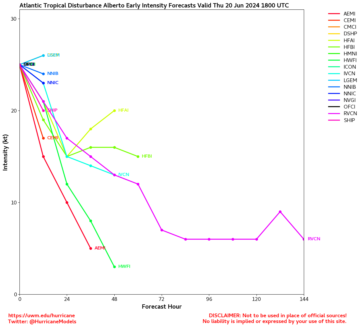
Forecast Lounge is up on Storm 01L Lounge
Elsewhere, we have keen eyes on the presently non-tropical area of low pressure to the east of the Bahamas and also have a Forecast Lounge up for it as well: Area East of Bahamas Forecast Lounge
PTC-01L Event Related Links

SFWMD Model Plot (Animated Model Plot) SFWMD Hurricane Page
Tropical Tidbits Page on system
[https://flhurricane.com/floatanimator.php?year=2024&storm=1 Flhurricane Satellite Floater Animation of Storm 01L
GOES Floater
Animated Skeetobite Model Plot of Storm 01L
Clark Evans Track Model Plot of Storm 01L
(Animated!) Model Plots in Google Earth - In Google Maps
Clark Evans Intensity Model Plot of Storm 01L (Animated!)
Clark Evans Track Plot of Storm 01L
Clark Evans Top 10 Analog Storms for Storm 01L
More model runs on from RAL/Jonathan Vigh's page
NRL Info on Storm 01L -- RAMMB Info
COD Atlantic Satellite View
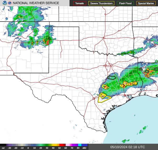
Texas Gulf Coast Links [http://moe.met.fsu.edu/~mnissenbaum/radar.html Mark Nissenbaum's radar page}
Texas Composite Radar Loop (Latest Static) East to West:
Houston/Galveston, TX Radar Radar Loop (Latest Static)
Corpus Christi, TX Radar Radar Loop (Latest Static)
Brownsville, TX Radar Radar Loop (Latest Static)
Gulf of Mexico Satellite Imagery
Area Forecast Discussions: Houston/Galveston, TX - Corpus Christi, TX - Browsnville/South Padre Island, TX
East Florida Links Southeast Composite Radar Loop (Latest Static) South to North:
Key West, FL Radar Radar Loop (Latest Static)
Miami, FL Radar Radar Loop (Latest Static)
Melbourne, FL Radar Radar Loop (Latest Static)
Jacksonville, FL Radar Radar Loop (Latest Static)
Caribbean/South East Coast Satellite Imagery
SFWMD Radar Loop of South Florida with storm Track
SFWMD Full Florida Radar Loop with Storm Track
Area Forecast Discussions:
FLorida Keys -
Miami/South Florida -
Melbourne/East Central Florida -
Jacksonville/Northeast Florida -
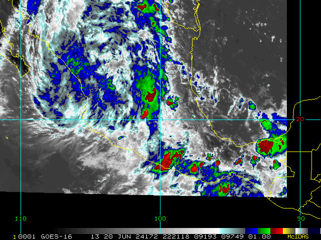
The large and sprawling Central American Gyre now has two main areas of enhanced/enhancing vorticity associated with it. First, newly-tagged Invest 91L that is attempting to consolidate and build down towards the surface in the southwestern Bay of Campeche (SW Gulf of Mexico), and Invest 90E on the Eastern Pacific side that has moved inland over Central America and is currently being absorbed by the parent Gyre.
NHC odds are now up to 70% within 48 hours that Invest 91L becomes a bona fide tropical cyclone in the western Gulf. There is a lot of potential for this system to create regional and localized significant and life-threatening flooding with several days of rains and thunderstorms, regardless of development.
Elsewhere, well east of the Bahamas the weak non-tropical low that has developed on the tail-end of an old front and residuals of old 90L still has has a fair chance of becoming a subtropical or tropical cyclone before crossing back over Florida and/or the southeastern US in a few days.
-Ciel
91L Event Related Links


SFWMD Model Plot (Animated Model Plot) SFWMD Hurricane Page
Tropical Tidbits Page on system
[https://flhurricane.com/floatanimator.php?year=2024&storm=91 Flhurricane Satellite Floater Animation of Invest 91L
GOES Floater
Animated Skeetobite Model Plot of Invest 91L
Clark Evans Track Model Plot of Invest 91L
(Animated!) Model Plots in Google Earth - In Google Maps
Clark Evans Intensity Model Plot of Invest 91L (Animated!)
Clark Evans Track Plot of Invest 91L
Clark Evans Top 10 Analog Storms for Invest 91L
More model runs on from RAL/Jonathan Vigh's page
NRL Info on Invest 91L -- RAMMB Info
COD Atlantic Satellite View
8AM 16 June 2024 Update
The area in the Atlantic is now up to a 30% chance for development, with the area highlighted from all of the east coast of Florida into Georgia currently. This likely will be a fast moving rain maker for wherever it makes landfall, and just to the right of that. Likely as early as Thursday.
The area in the gulf is about 60% chance and also most likely a flooding rain maker (albeit a slower moving one than the Atlantic) for Northern Mexico and Parts of Southeastern Texas.
Both should be continued to watch this week.
Original Update
There are two areas of Interest currently, one area in the gulf now has a 60% chance to develop, and this Gulf area is likely not to get too strong, however it could dump flooding rains over Mexico and parts of Texas, including San Antonio and Austin.
The new area is 20% east of the Bahamas and could arrive to Florida or Georgia by Thursday later this week.
This system would arrive mid to late week (Thursday-Friday) before anything would happen there, and moving quickly so time is likely to keep it weaker, and bring some rain (but rain likely won't linger as long).
Texas Gulf Coast Links [http://moe.met.fsu.edu/~mnissenbaum/radar.html Mark Nissenbaum's radar page}
Texas Composite Radar Loop (Latest Static) East to West:
Houston/Galveston, TX Radar Radar Loop (Latest Static)
Corpus Christi, TX Radar Radar Loop (Latest Static)
Brownsville, TX Radar Radar Loop (Latest Static)
Gulf of Mexico Satellite Imagery
Area Forecast Discussions: Houston/Galveston, TX - Corpus Christi, TX - Browsnville/South Padre Island, TX
East Florida Links Southeast Composite Radar Loop (Latest Static) South to North:
Key West, FL Radar Radar Loop (Latest Static)
Miami, FL Radar Radar Loop (Latest Static)
Melbourne, FL Radar Radar Loop (Latest Static)
Jacksonville, FL Radar Radar Loop (Latest Static)
Caribbean/South East Coast Satellite Imagery
SFWMD Radar Loop of South Florida with storm Track
SFWMD Full Florida Radar Loop with Storm Track
Area Forecast Discussions:
FLorida Keys -
Miami/South Florida -
Melbourne/East Central Florida -
Jacksonville/Northeast Florida -