CFHC Talkback For News Story #108:
Newest Talkback: 10:43 PM 09-21 EDT

Tropical Storm Watches... TD#13 Forms in East Atlantic
10:54 AM EDT - 21 September 2000

5PM Update:
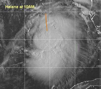
Hurricane Watches are up from Florida/Alabama Border to the mouth of the Alucilla River to the east. Helene has a chance of becoming a minimal hurricane before landfall. Right now the center is nearly exposed, so it's holding on. However, I still think it may strengthen. In any case, this is another big rain bringer. TD#13 hasn't strengthened any yet.

Busy again. Tropical Depression #13 forms in the east Atlantic.

It should track generally westward for the moment and eventually turn north. If in two days or so it doesn't turn north then a more westward track is possible.

Tropical Storm Helene has prompted Tropical Storm Warnings from the mouth of the Pearl River to the mouth of the Aucilla river. It could become a strong Tropical Storm before landfall, and a minimal hurricane is not out of the question either.

More to come later...

Helene

Comments or Questions? Everyone is invited to use it. Use the comment button by the story Headline.

Joseph Johnston's Mobile Alabama Webcam (Hosted on CFHC)

NRL Monterey Marine Meteorology Division Forecast Track of Active Systems (Good Forecast Track Graphic and Satellite Photos)
Map with nearly all model projected tracks plotted for Helene. And TD#13 From Michael Bryson.
Crown Weather Services Tropical Update (Includes Map with multiple forecast model tracks)
Snonut's Hurricane Reports
Satellite images at: [Visible] (visible -- Daytime Only) [Infrared] (infrared), and [Water Vapor] (water vapor)
Loops: Visible Loop - Infrared Loop - Water Vapor Loop
NASA GHCC Interactive Satellite images at:
[NAtl visible] (visible -- Daytime Only) [NAtl infrared] (infrared), and [NAtl water vapor] (water vapor)--Nasa source.
Ocean Surface Winds Derived from the SeaWinds Scatterometer (Experimental)
Tormenta.net Español -- Gran información sobre huracanes aquí.

Some Forecast models: (NGM, AVN, MRF, ECMWF, ETA)
DoD weather models (NOGAPS, AVN, MRF)
AVN, ECMWF, GFDL, NOGAPS, UKMET

- [mac]


Show All Comments | Show Previous 3 Comments

Displaying Talkbacks #37 - #39 (of 39 total)

Helene (#37)
Posted by:
Joseph Johnston Location: Mobile, AL
Posted On 06:32PM 21-Sep-2000 with id (RTNQXNRUNQPY*)


For any of you looking at the Mobile, Al. web cam, for some reason the T 1 line has gone out (wouldn't you know it?) We are trying to get it going. Just light rain and wind here.

Correction... (#38)
Posted by:
Frank Location: Biloxi MS
Posted On 06:33PM 21-Sep-2000 with id (QURNQVSNQYUNRPR*)


The center is not enlongating, just a lack a convection on the west side during a segment of a satellite loop.

Latest NRL vis sat loop indicated center at 27.95 N and 87.15 W. LLC easy to see and determine center.... system LLC is really exposed right now...

LLCC (#39)
Posted by:
Richard Byett (http://www.atlantic-technologies.co.uk) Location: Gloucester, England, UK
Posted On 06:43PM 21-Sep-2000 with id (RQRNQSYNQWTNQR*)


Although the LLCC is exposed it appears as if clouds are now beginning to try and build around the north and western side of it. What does anyone sle think?
Incidently i also think we will see a slightly east path compared to the nhc forecast, but i dont think they will be far wrong.


Show All Comments | Show Previous 3 Comments


Return to Central Florida Hurricane Center Main Page