CFHC Talkback For News Story #55:
Newest Talkback: 07:08 PM 07-14 EDT

More on TD#2
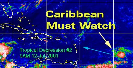
09:58 AM EDT - 12 July 2001

Tropical Depression #2 is looking a litte different this morning, a little more concentrated and more tropical looking. I expect to see Barry today.

For it's future, it now appears as if it will head to the Eastern Leeward islands an a minor system. Many models have it entering and staying in the Caribbean. Climatology isn't favorible for it, and if it does creep north it'll have to deal with the mountains of Hispaniola.

It won't get much chance to strengthen over that Island. There is enough to suggest it could reach minor hurricane strength, so folks will need to watch.

Persistence again will be paramount. Beyond that, it still could effect Florida in some way next week if the stalled out front does not itself. But if it does go through the caribbean and Hispaniola it won't have enough to recover. In any case, the Caribbean needs to watch this one very closely for right now, and we may later depending on what path this thing takes. It probably won't touch us at all, but the chance is still there so I mention it.

TD#2! Barry later?


What about the models? The GFDL continues to want to toss this system in the trash, but moves it slowly toward the Caribbean. The MRF keeps it in the Caribbean and mostly south of the islands. The others all do various tricks with it, but climatology is a major factor in that. This is an early cape verde style system, and it has a lot going against it.

Watch!

Caribbean Hurricane Page - Updates from the various Caribbean Islands.

NRL Monterey Marine Meteorology Division Forecast Track of Active Systems (Good Forecast Track Graphic and Satellite Photos)

NASA GHCC Interactive Satellite images at:
[NAtl visible] (visible -- Daytime Only) [NAtl infrared] (infrared), and [NAtl water vapor] (water vapor)--Nasa source.
Defiant Visible Infrared More...
Other commentary at: Mike Anderson's East Coast Tropical Weather Center - Accuweather's Joe Bastardi - SCOTTSVB's Hurricane Update Center - Jim Williams' Hurricane City - Gary Gray's Millennium Weather - Even More on our Links Page

Some Forecast models: (NGM, AVN, MRF, ECMWF, ETA)
DoD weather models (NOGAPS, AVN, MRF)
AVN, ECMWF, GFDL, NOGAPS, UKMET

- [mac]


Show All Comments | Show Next 3 Comments | Show Previous 3 Comments

Displaying Talkbacks #4 - #6 (of 24 total)

We he hold (#4)
Posted by: Joe Location: St.Petersburg, FL
Posted On 11:15AM 12-Jul-2001 with id (RQVNSNQXRNQPY*)


Thats a big question right now. Theres a chance it will but theres also a chance it won't. Never the less it needs to be watched, not writing this system off any time soon. 11 AM update still holding its same strength at 30 mph, with foward speed increasing a bit up to WNW at 20 mph so its moving. Other good points where brought up in the posts ubove about the western Caribbean and norhtern Gulf. So lots to watch. I was a bit concerned with the north gulf earlier in the week when I found out a front was coming all the to the Gulf Coast. But shear is is strong in both areas. So lots to watch this weekend.

td2 weakening? (#5)
Posted by:
doug Location: tampa
Posted On 12:37PM 12-Jul-2001 with id (VUNSTNVVNQVP*)


Current visible loop suggests that the convection, such as there is in TD 2, is being pushed west faster than the c of c, which may actually be exposed in the last frame. Not conducive for rapid development....the larger mass exiting N from Houndouras is more threatening visually, and visible suggests some rotation there. I agree be vigilant as the atmosphere is volatile right now. EDS.

TD #2 et al continued... (#6)
Posted by: Steve Location: Old Metairie, LA
Posted On 01:34PM 12-Jul-2001 with id (RPXNRTXNRSQNUX*)


Check out the MRF Day #6, 7 8 and 9. It looks like MRF is trying to put in a mid level anticyclonic circulation in the central gulf with an upper low over west-central florida. So early next week may also offer some exicitement as noted by the host.

Steve

Tropics heating up? (#7)
Posted by: Joe Location: St.Petersburg, FL
Posted On 02:41PM 12-Jul-2001 with id (VTNRTTNQNTU*)


Yeah took a look and it did point out a mid level anticyclone in central gulf. With upper low of west central florida. Another thing I find intresting is the convection down by Honduras whats your thoughs on theses features.
Thanks Joe


Show All Comments | Show Next 3 Comments | Show Previous 3 Comments


Return to Central Florida Hurricane Center Main Page