danielw
|
| (Moderator) |
| Thu Sep 30 2004 01:41 AM |

|
|
|
Jeanne's remnants were located about 200 miles east of New York City,NY at 11:00AM EDT on September 29, 2004.
Maximum sustained winds re 25mph with higher gusts.
The remnants of Jeanne are moving E at 30mph, and forecast to move ENE over the Atlantic.
Damage along the coast from storm surge was greater this time than in Frances, including our place in New Smyrna Beach which lost the beach walkway and about 8 feet of concrete walkway behind the seawall.
Lisa is located, at 5PM EDT-Wednesday, 1180 WSW of the Azores Islands. Moving N at 12mph. Maximum sustained winds are 70mph. Lisa is forecast to be absorbed by the remnants of Jeanne.
Lisa is already destined to be a fish spinner... so that leaves us with...
NOTHING! Hold a party... no storms currently. The season isn't over yet, but there is no discernable storm threats in the forseeable future.
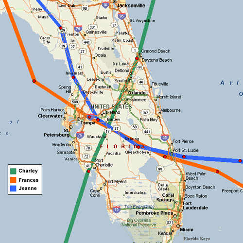
Skeetobite shows the paths of all three central Florida storms...

Event Related Links
You can find links to County Emergency Management offices at floridadisaster.org
Jeanne Color Satellite
Various Audio/Video Feeds from hurricane affected areas
Hurricane Local Statements for Weather Offices in:
All Current Hurricane Local Statements
Mark Sudduth is doing video updates as he heads toward Vero to set up his reasearch team. Check on it here.
Hurricanetrack HIRT vehicle (camera, and more)
Jeanne Models -- This image animated over time
Karl Models -- This image animated over time
Lisa Models -- This image animated over time
Jeanne Sphagehtti Model from BoatUS/Hurricane Alley
Jeanne Plots from Weather Underground
Jeanne Satelllite Image with track/radar Overlays
Jeanne Radar Image
Forecast Discussions for (Show All Locations):
Tampa. Miami, Key West, Jacksonville.
Melbourne
General Links
Skeetobite's storm track maps
Current Aircraft Recon Info (Decoded) thanks Londovir
Other Recon Info
NRL Monterey Marine Meteorology Division Forecast Track of Active Systems (Good Forecast Track Graphic and Satellite Photos)
Check the Storm Forum from time to time for comments on any new developing system.
Follow worldwide SST evolution here:
Global SST Animation
NASA GHCC Interactive Satellite images at:
North Atlantic Visible (Daytime Only), Infrared, Water Vapor
LSU Sat images
RAMSDIS Satellite Images (high speed)
Some forecast models:
NGM, AVN, MRF, ETA ECMWF
AVN, CMC,GFDL, JMA,NOGAPS,UKMET
DoD Weather Models (NOGAPS, AVN, MRF)
Multi-model plots from Mid-Atlantic Weather
Other commentary at Independentwx.com, Robert Lightbown/Crown Weather Tropical Update Accuweather's Joe Bastardi (now subcriber only unfortunately), Hurricane Alley North Atlantic Page, Hurricanetrack.com (Mark Sudduth), HurricaneVille, Cyclomax (Rich B.), Hurricane City , mpittweather , WXRisk, Gary Gray's Millennium Weather, storm2k, Barometer Bob's Hurricane Hollow, Snonut,
Even more on the links page.