MikeC
|
| (Admin) |
| Sat Jul 09 2005 03:21 AM |
|
|
7:05AM Update

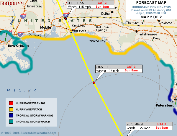
Dennis is back up to Category 2, unfortunately, even with the drop to Category 1 this morning, Dennis core did not completely collapse, giving it the opportunity to restrengthen. In fact, recon is reporting that the eye wall is closed again all around.
I suspect it will regain its major hurricane status sometime today.
The radar for the Panhandle, located at Eglin Air Force Base (KEVX), has had a motor failure, keepiing that off. There is a rush to replace it, so hopefully we'll have that to look at and study before the day is out.

6:45AM Update
Dennis is back to a Category 1, weakening even more than I thought it wuold over Cuba. Although bad for Cuba, this is better news for us. Depending on how much the eye collapsed, storms tend to have a more difficult time reforming after such a drop in windspeed. Dennis retained a lot of its structure though, so strengthening is still possible. I"d still expect a major hurricane at landfall, but not a Category 4.
The other good news is that it tracked further west, being further west away from Key West, so they won't receive the full brunt of the system. Much of the Florida Peninsula will get feeder bands today, and it will generally be a bad day to be out. There exists the potential for nasty dounbursts, and short lived tornadoes.
I'm slightly relieved this morning because of those two things, but I'm not sure how much it will matter for the Gulf coast. Forecast track is still good, in my opinion.
Many people ask about how Charley made a "ight turn" into Central Florida. But you have to remember it was still well within the cone of error, and was predicted to make a west coast Florida landfall. Dennis has neither.
Beyond Dennis, the wave in the central Atlantic is starting to get tis act together, and may become a depression before the weekend is out.
Original Update
Dennis is back down to a Category 2 storm, after spending a bit more time over Cuba than originally expected. It is forecast to regain strength back into a Category 3 storm.

The Florida keys will see winds pick up more and more tonight. But the storm is staying far enough west to not have a direct landfall there.

The future track still puts it up toward the western panhandle, with the potential area from Louisiana to the Panhandle of Florida.
Tomorrow the Florida peninsula will see feeder bands, possible tornadoes, and short but heavy bands of rain move through along with being a general breezy day. Tropical storm force winds may be confined to the extreme west coast of Central Florida.
More tomorrow...
I'm looking for good Dennis related links to place on the front page; this includes good images, radar, satellite, streaming audio,video, emergency information, etc. Reply and let us know.
Site Note News talkbacks are now in lockdown mode, which means that unregistered users cannot reply.
You can still post in the other forums besides talkbacks. This enables us to moderate a lot better. I hate doing this, but I can see obvious signs of "storm stress" on a few individuals. We'll make it open again as soon as it calms down.
Registration is open for anyone, you can register Using this link. Then you will be able to reply here.
Hopefully this will only last a short time.
Event Related Links
Emergency Management
Gulf Coast Storm Alert Network
FloridaDisaster.org - Florida Emergency Management
Monroe County/Florida Keys,
Panhandle Coastal Counties West to East
Escambia County, FL, Santa Rosa, County, Okaloosa County, FL,
Walton County, FL,
Bay County, FL, Gulf County, FL, Franklin County, FL
Mississippi Emergency Management Agency (MEMA)
http://www.msema.org/index.htm
StormCarib hurricane reports from observers in the Islands - Jamaican StormCarib Reports
Caribbean Island Weather Reports
Guantanamo Bay, Cuba Radar
Florida Keys Long Range Radar Loop
Tampa Bay, FL Long Range Radar
Miami, FL Long Range Radar
Melbourne, FL Long Range Radar
Tallahassee, FL Long Range Radar
Mobile, AL Long Range Radar
Casablanca, Cuba Radar
Dennis
High Speed Storm Relative Floater - RAMSDIS ONLINE
Animated Model Plot of Dennis
Model Plot Graphic from the South Florida Water Management District of Dennis
Dennis Spaghetti Model from boatus
Weather Underground Model Plots for Dennis
Quikskat Image of Dennis
Color Sat of Dennis
Floater Satellite (Visible) of Dennis with Storm Track Overlays
Cienfuegosa, Cuba Radar - (Animated)
RAMSDIS high speed visible Floater of Dennis
Webcams, Video, Audio
Mark Sudduth's at coastal Alabama again ready to move east or west, he has a mobile observation tower he'll be leaving along the coast when Dennis arrives - Hurricane Trak/Mark Suddth Car & Tower Cam
Suncam.tv's collection of Dennis cam's and Mobile (not the city) cams - Suncam.tv's Moble Car Cam
Hurricane City and Jim Williams do audio shows nightly around 8PM
Joseph Johnston's Mobile Bay Webcam
Key West Webcams
New Orleans webcams
Radio Habana, Cuba
Forecast Discussions for (Show All Locations):
Tampa, Mobile Bay,
New Orleans, Key West, Tallahassee.
Melbourne