MikeC
|
| (Admin) |
| Fri Jul 08 2005 10:30 AM |
|
|
3PM
Dennis has made landfall near or just west of Cienfuegosa, Cuba (the same location as the radar below) and has weakened just a tad, but remains a strong Category 4 storm. New forecast track reasoning and analysis added from Clark Evans in the Met Blogs below.


Original Update
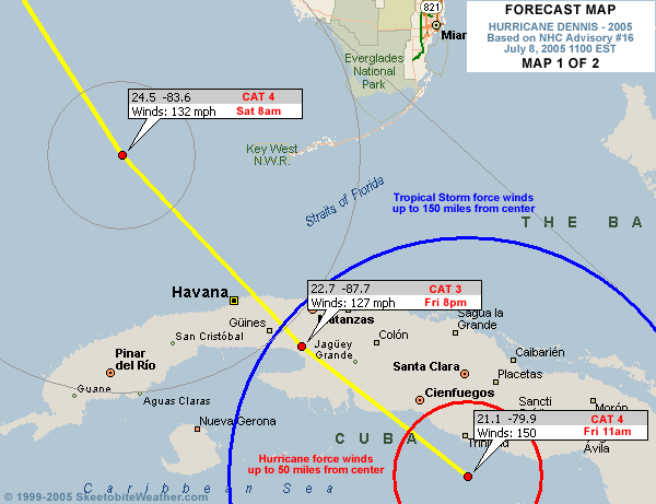
Dennis is a strong Category 4 storm with winds of 150mph as of 11am, and the track takes it to the eastern Gulf and eventually toward the Panhandle to New Orleans regions Sunday night and Monday morning. Radar imagery (below) and reconnaissance observations indicate a potential eyewall replacement cycle to come, though this might be interrupted by time over land this afternoon as it heads for the Gulf of Mexico. The track now takes it west of Key West.
Satellite imagery and upper air observations across the southern United States indicate that the ridge axis may be shrinking north-south with the approach of the storm, with a rather vigorous shortwave trough located along the Texas coast. It is not making much progress eastward at this time, though the southern extent over northern Mexico is building southward. Additional energy currently over the central Plains is headed south towards this shortwave and should help move it east -- how far east and how strong at that point will deternine when exactly Dennis makes its turn, as well as how sharp of a turn it will be.
The rest of the Gulf awaits as it crosses Cuba and everyone from Louisiana east to South Florida needs to pay close attention to the overall track of the storm through the day.

The following is a mirrored radar image from Cienfuegosa, Cuba, through 10:30am local time as Dennis approached, making landfall just west of the radar at 2pm ET. The radar continues to transmit images, but with a couple hours' delay.

Site Note News talkbacks are now in lockdown mode, which means that unregistered users cannot reply.
You can still post in the other forums besides talkbacks. This enables us to moderate a lot better. I hate doing this, but I can see obvious signs of "storm stress" on a few individuals. We'll make it open again as soon as it calms down.
Registration is open for anyone, you can register Using this link. Then you will be able to reply here.
Hopefully this will only last a short time.
Event Related Links
Emergency Management
FloridaDisaster.org - Florida Emergency Management
Monroe County/Florida Keys,
Panhandle Coastal Counties West to East
Escambia County, FL, Santa Rosa, County, Okaloosa County, FL,
Walton County, FL,
Bay County, FL, Gulf County, FL, Franklin County, FL...
StormCarib hurricane reports from observers in the Islands - Jamaican StormCarib Reports
Caribbean Island Weather Reports
Guantanamo Bay, Cuba Radar
Florida Keys Long Range Radar Loop
Tampa Bay, FL Long Range Radar
Miami, FL Long Range Radar
Melbourne, FL Long Range Radar
Tallahassee, FL Long Range Radar
Mobile, AL Long Range Radar
Dennis
High Speed Storm Relative Floater - RAMSDIS ONLINE
Animated Model Plot of Dennis
Model Plot Graphic from the South Florida Water Management District of Dennis
Dennis Spaghetti Model from boatus
Weather Underground Model Plots for Dennis
Quikskat Image of Dennis
Color Sat of Dennis
Floater Satellite (Visible) of Dennis with Storm Track Overlays
Cienfuegosa, Cuba Radar - (Animated)
RAMSDIS high speed visible Floater of Dennis
Forecast Discussions for (Show All Locations):
Tampa. Mobile Bay,
New Orleans, Key West, Tallahassee.
Melbourne