MikeC
|
| (Admin) |
| Thu Jul 07 2005 03:01 PM |
|
|
4:50PM
Hurricane Dennis is now a Category 3 storm, more to come soon. Forecast track remains quite similar to the last one. Overall, the track has been numerically close to right on so far.
Hurricane Warnings are now posted for the lower Florida Keys, as tropical storm force winds may be approaching there tomorrow afternoon.
2:40PM
Pressure in Dennis has fallen to 956mb, possibly putting it over the edge for a Category 3 storm. We'll know in a bit.
2:00PM
Dennis is now 110MPH winds, very near Category 3 strength. And still about 65 miles away from Kingston in Jamaica. (To the Northeast)
Visitor and Nonresident evacuations have been ordered for the Florida Keys.
Meteorologists Clark Evans and Ed Dunham have discussions about Dennis, which you can find below this article or by clicking the Met blogs link on the left.
Original Update
The Florida Keys are now under a Hurricane Watch, including Florida Bay. South Florida from Golden Beach on the east coast, to Bonita Beach on the West coast are under a tropical storm watch.

It is still approaching Jamaica, and has a chance to strengthen some more. Interaction with Cuba should weaken it a bit before it gets in the Gulf, how much is up for debate, however.
An eye is now apparant on Visible Satellite Images

This was forced because of track uncertainties in the models. Check the Monroe County EM link below for Keys Evac information.
The track still takes it toward the Western Panhandle... More to come soon.
Event Related Links
Monroe County/Florida Keys Emergency Management Bulletins
StormCarib hurricane reports from observers in the Islands - Jamaican StormCarib Reports
Caribbean Island Weather Reports
Jamaican Meteorological Service
Guantanamo Bay, Cuba Radar
Florida Keys Long Range Radar Loop
Dennis
Animated Model Plot of Dennis
Model Plot Graphic from the South Florida Water Management District of Dennis
Dennis Spaghetti Model from boatus
Weather Underground Model Plots for Dennis
Quikskat Image of Dennis
Color Sat of Dennis
Floater Satellite (Visible) of Dennis with Storm Track Overlays
RAMSDIS high speed visible Floater of Dennis
Forecast Discussions for (Show All Locations):
Tampa. Mobile Bay,
New Orleans, Key West, Tallahassee.
Melbourne
| hurricane_run |
| (Storm Tracker) |
| Thu Jul 07 2005 03:24 PM |

|
|
|
looks like Jamaica is about to be hammered
| Lysis |
| (User) |
| Thu Jul 07 2005 03:28 PM |

|
|
|
Wow... he is opening up his eye:
This is incredible. I remember when he was just a blob of convection. It is like watching a child grow up. ...Who just happens to become a mass murderer
http://www.ssd.noaa.gov/PS/TROP/DATA/RT/float2-vis-loop.html
| hurricane_run |
| (Storm Tracker) |
| Thu Jul 07 2005 03:30 PM |
|
|
|
|
from the disscusion. full at the home page. FIXES FROM RECONNAISSANCE AIRCRAFT AND SATELLITE INDICATE THAT THE
MOTION HAS BEEN MORE NORTHWESTWARD THAN WEST-NORTHWESTWARD. THE
MID-TROPOSPHERIC RIDGE TO THE NORTH OF DENNIS IS APPARENTLY WEAKER
THAN EARLIER PREDICTED. THIS MAY IN PART BE A RESULT OF ADDITIONAL
STEERING FLOW INFORMATION OBTAINED FROM THE NOAA G-IV JET
SURVEILLANCE MISSION LAST NIGHT. CONSEQUENTLY...SOME OF THE TRACK
GUIDANCE...IN PARTICULAR THE GFDL AND GFS MODELS...HAVE SHIFTED TO
THE RIGHT OF THEIR EARLIER SOLUTIONS. THIS NECESSITATES AN
EASTWARD ADJUSTMENT OF THE OFFICIAL TRACK. ADDITIONALLY...THE
AIRCRAFT DATA SHOW THAT DENNIS HAS STRENGTHENED AND THAT THE WIND
FIELD HAS EXPANDED...ESPECIALLY TO THE NORTHEAST. THE NEW TRACK
AND WIND FIELD FORECAST REQUIRES THE ISSUANCE OF WATCHES FOR
EXTREME SOUTHERN FLORIDA AT THIS TIME.
| Jax Chris |
| (Weather Watcher) |
| Thu Jul 07 2005 03:31 PM |
|
|
Quote:Sure does; at least it looks like they're going to be on the south side of the eye, so that'll help them somewhat. Unless Dennis decides to drop down and pick up some rum, mon... Doesn't look like Cuba and the US Gulf Coast are going to be so lucky; somebody's going to be on the windward side for both of those.
looks like Jamaica is about to be hammered
Jax Chris
| hurricane_run |
| (Storm Tracker) |
| Thu Jul 07 2005 03:31 PM |
|
|
|
|
I know exactly what you mean.
| Unregistered User |
| (Unregistered) |
| Thu Jul 07 2005 03:33 PM |
|
|
Would expect a cat 3 hurricane at next advisory.
| hurricane_run |
| (Storm Tracker) |
| Thu Jul 07 2005 03:33 PM |
|
|
|
|
and that is not good.
| FlaRebel |
| (Weather Hobbyist) |
| Thu Jul 07 2005 03:34 PM |
|
|
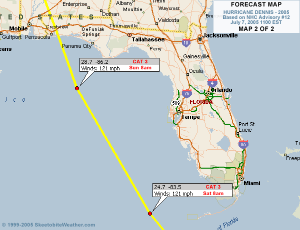
I assume on the second map the location for 121 MPH winds is 8 AM Saturday??
| pcola |
| (Storm Tracker) |
| Thu Jul 07 2005 03:39 PM |

|
|
|
Accuweather is still sticking to its guns and saying Mississippi.
| hurricane_run |
| (Storm Tracker) |
| Thu Jul 07 2005 03:43 PM |
|
|
|
|
once it gets to 100kts (major status) it should be interesting to see how it acts.
( It really interested in CERC in hurricanes) and how they effect strength and direction.
( My thoughts and prayers go out to those in London.)
| Unregistered User |
| (Unregistered) |
| Thu Jul 07 2005 03:43 PM |
|
|
What is everyone predicting for rainfall amounts when Dennis reaches the U.S??
| hurricane_run |
| (Storm Tracker) |
| Thu Jul 07 2005 03:45 PM |
|
|
|
|
that eye is clearing up that is not a good sign. When is the next recon ETA at the storm?
| Bloodstar |
| (Moderator) |
| Thu Jul 07 2005 03:49 PM |

|
|
|
Quote:
once it gets to 100kts (major status) it should be interesting to see how it acts.
( It really interested in CERC in hurricanes) and how the effct strenght.
The way I visualize things, if the storm is large and major, it's going to tend to go straight. there will be wobbles, but it usually sticks to that path until something really starts to steer it. Once it hits Cuba... weakens a bit... I think that's when you'll see the potential for a turn. We shall see...
And to think, I'm heading to Atlanta in a few hours, and I'm supposed to drive back sunday day/evening.
Guess I'll be watching to see if I'm even going to be allowed back!

-Mark
|
SkeetoBite
|
| (Master of Maps) |
| Thu Jul 07 2005 03:49 PM |
|
|
|
|
Quote:
I assume on the second map the location for 121 MPH winds is 8 AM Saturday??
Oops! Good catch. Fixed.
| Unregistered User |
| (Unregistered) |
| Thu Jul 07 2005 03:51 PM |
|
|
12Z GFS further east through 36 hours....looks to be crossing Key West on this run.
| Unregistered User |
| (Unregistered) |
| Thu Jul 07 2005 03:53 PM |
|
|
I think the eye is just a little bit north of the original track...
| hurricane_run |
| (Storm Tracker) |
| Thu Jul 07 2005 03:57 PM |
|
|
|
|
there is always going to be wobbles and changes in course. the storm will not go along the predicted path. but is it goes over cubas mountains for awhile maybe it will weaken it somewhat before it can cause considerable damage.
| Clark |
| (Meteorologist) |
| Thu Jul 07 2005 04:02 PM |
|
|
Full update coming on the met. blogs on the front page, but here are the highlights:
* Dennis' northwesterly jog will spare the island of Jamaica from the worst, but they will still be dealing with hurricane-force winds for some time. Areas on the north side of the island will be especially prone to flooding due to the higher terrain & flow up the mountains towards the south.
* The eye is becoming better defined in satellite imagery; Dennis may be peaking near major hurricane intensity before land interactions begin to slow it down somewhat. Recon is on its way and a fix is due for the next hour or two.
* Models are trending further and further east with time, coming into line with the FSUMM5 but still a bit west of the Canadian model. The upper-air pattern is becoming a bit better defined and the data input to the models from the surveillance plane has had a noticeable impact on the projected path of the storm.
More on track & intensity forecast and synoptic reasoning within the next half-hour.
| Frank P |
| (Veteran Storm Chaser) |
| Thu Jul 07 2005 04:06 PM |
|
|
I predict the rain to be horizontal....

| Jax Chris |
| (Weather Watcher) |
| Thu Jul 07 2005 04:07 PM |
|
|
Quote:(/me playing Mr. Links today...) NOAA makes the Plan of the Day (and plan of tomorrow) available through http://www.nhc.noaa.gov/reconlist.shtml. The current plan is:
When is the next recon ETA at the storm?
Code:
000
NOUS42 KNHC 061700
WEATHER RECONNAISSANCE FLIGHTS
CARCAH, TPC/NATIONAL HURRICANE CENTER, MIAMI, FL.
0100 PM EDT WED 06 JULY 2005
SUBJECT: TROPICAL CYCLONE PLAN OF THE DAY (TCPOD)
         VALID 07/1100Z TO 08/1100Z JULY 2005
         TCPOD NUMBER.....05-040

I.  ATLANTIC REQUIREMENTS
    1. TROPICAL STORM DENNIS
       FLIGHT ONE                    FLIGHT TWO
       A. 07/1800,08/0000Z           A. O8/0000Z
       B. AFXXX 0404A DENNIS         B. NOAA9 0504A DENNIS
       C. 07/1430Z                   C. 07/1800Z
       D. 19.0N 77.4W                D. NA
       E. 07/1700Z - 08/0030Z        E. NA
       F. SFC TO 10,000 FT           F. 41,000-45,000 FT

       FLIGHT THREE                  FLIGHT FOUR
       A. 08/0000Z                   A. 08/0600Z
       B. AFXXX 0604A DENNIS         B. NOAA2 0704A DENNIS
       C. 07/1800Z                   C. 08/0430Z
       D. NA                         D. 20.4N 79.8W
       E. NA                         E. 08/0530Z - 08/0900Z
       F. 24,000 T0 30,000 FT        F. SFC TO 10,000 FT

       FLIGHT FIVE
       A. 08/1200,1800Z
       B. AFXXX 0804A DENNIS
       C. 08/0800Z
       D. 21.1N 80.9W
       E. 08/1100Z TO 08/1830Z
       F. SFC TO 10,000 FT

    2. OUTLOOK FOR SUCCEEDING DAY: CONTINUE 6-HRLY FIXES. A G-IV
       FLIGHT FOR 09/0000Z.
So it looks like the next recon fix is by flight 1, and is at 1800Z (line A), or 2 p.m. EDT. The plane will be on site at 1700Z (1 p.m. EDT) and stay there until 08/0030Z (8:30 p.m. today EDT, line E). Unless I'm reading this totally wrong

Edited to put in and discuss today's plan instead of tomorrow's

Jax Chris
| ftlaudbob |
| (Storm Chaser) |
| Thu Jul 07 2005 04:13 PM |
|
|
|
|
Quote:When you say futher and further east,does that mean you think S FL maybe more under the gun?Also the eye is north of Jamaica,not really THAT close. http://www.boatus.com/hurricanes/hurricane_satellite2.asp
Full update coming on the met. blogs on the front page, but here are the highlights:
* Dennis' northwesterly jog will spare the island of Jamaica from the worst, but they will still be dealing with hurricane-force winds for some time. Areas on the north side of the island will be especially prone to flooding due to the higher terrain & flow up the mountains towards the south.
* The eye is becoming better defined in satellite imagery; Dennis may be peaking near major hurricane intensity before land interactions begin to slow it down somewhat. Recon is on its way and a fix is due for the next hour or two.
* Models are trending further and further east with time, coming into line with the FSUMM5 but still a bit west of the Canadian model. The upper-air pattern is becoming a bit better defined and the data input to the models from the surveillance plane has had a noticeable impact on the projected path of the storm.
More on track & intensity forecast and synoptic reasoning within the next half-hour.
| Dougyd |
| (Verified CFHC User) |
| Thu Jul 07 2005 04:17 PM |
|
|
Wondering - When Dennis hits Cuba heading at an angle, would one expect the land/mountains cause it to bend more toward the West, North or have no influence on the general direction?
Thanks
| Unregistered User |
| (Unregistered) |
| Thu Jul 07 2005 04:21 PM |
|
|
Channel 10 out of tampa just showed gulf temps at 91 F.
| Unregistered User |
| (Unregistered) |
| Thu Jul 07 2005 04:22 PM |
|
|
Those new models runs coming out are a little too close to the coast for comfort.
| twizted sizter |
| (Weather Guru) |
| Thu Jul 07 2005 04:23 PM |
|
|
If goes over the mountainous...is that a word?...will have an effect on the intensity.
| Unregistered User |
| (Unregistered) |
| Thu Jul 07 2005 04:24 PM |
|
|
Quote:
Accuweather is still sticking to its guns and saying Mississippi.
well, once the 12Z model runs come in, they will probably reconsider...maybe the CMC model will be correct all along?
| Unregistered User |
| (Unregistered) |
| Thu Jul 07 2005 04:25 PM |
|
|
People here in Pensacola are going nuts with this thing. We have always been around the center of the model tracking, but it is just a hurry up and wait type situation. I hate to wish this thing on someone else, but Ivan really tore us up in Sept of last year.
| Rick on boat in Mobile |
| (Weather Drama Guru) |
| Thu Jul 07 2005 04:25 PM |

|
|
|
it's always hotter in July and August in the Gulf...than in September...when hurricanes usually hit...
Camille hit in August....
if Gulf Temps are in the 90's....does that translate to a hyper-cane....I mean, not to be an alarmist or anything....but 200 mph winds are possible when the Gulf Temps are that warm....
any feed back on this will be appreciating....I'm just running with possibilities righ now...
| Unregistered User |
| (Unregistered) |
| Thu Jul 07 2005 04:25 PM |
|
|
The entire west coast of Florida (up through north of Tampa) can expect tropical storm force winds and flooding surge if the current track verifies...
| jth |
| (Storm Tracker) |
| Thu Jul 07 2005 04:26 PM |
|
|
if the CMC shifted west at 12Z as the others shifted east. That would be par for the course.
| mom2als |
| (Registered User) |
| Thu Jul 07 2005 04:26 PM |
|
|
Actually,Skeetobite, if I'm reading things right from your first map over Cuba, then on the second map, isnt the 8 am Friday near South Fl supposed to read Sat, thus the other one Sun? Either way, I love your maps despite the fact that you keep going over either my house in Kissimmee or my house in FWB. I sure wish you stop that!
| twizted sizter |
| (Weather Guru) |
| Thu Jul 07 2005 04:30 PM |
|
|
Yeah he is pretty adament with that..MS/LA landfall...believe he's going with UKMET which is the outlier & still persistant on that course.
| Unregistered User |
| (Unregistered) |
| Thu Jul 07 2005 04:30 PM |
|
|
Quote:
Channel 10 out of tampa just showed gulf temps at 91 F.
Need to look at the offshore bouy data.. No. 42036 100 miles west of Bayport FL has 83 deg Gulf Temps
Go to:
http://www.ndbc.noaa.gov/Maps/Florida.shtml
| Unregistered User |
| (Unregistered) |
| Thu Jul 07 2005 04:32 PM |
|
|
If gulf temps are this warm this thing has a chance to be an absolute monster
| Unregistered User |
| (Unregistered) |
| Thu Jul 07 2005 04:32 PM |
|
|
http://www.ssd.noaa.gov/PS/TROP/DATA/RT/float2-vis-loop.html
If you click on forcast points, the eye matches perfevtly
| ftlaudbob |
| (Storm Chaser) |
| Thu Jul 07 2005 04:33 PM |
|
|
|
|
Not to blow my own horn(I know that that is not what this forum is about)But is seems that what I feared a couple of days ago MAYBE happening.
| twizted sizter |
| (Weather Guru) |
| Thu Jul 07 2005 04:34 PM |
|
|
Nah...hair to the north.
| Unregistered User |
| (Unregistered) |
| Thu Jul 07 2005 04:34 PM |
|
|
Quote:
if the CMC shifted west at 12Z as the others shifted east. That would be par for the course.
Actually , that might be good in that it would imply convergence by the models..
| Unregistered User |
| (Unregistered) |
| Thu Jul 07 2005 04:38 PM |
|
|
Quote:Quote:
Channel 10 out of tampa just showed gulf temps at 91 F.
Need to look at the offshore bouy data.. No. 42036 100 miles west of Bayport FL has 83 deg Gulf Temps
Go to:
http://www.ndbc.noaa.gov/Maps/Florida.shtml
WTSP must get there temps from shallow waters.
| FlaMommy |
| (Storm Tracker) |
| Thu Jul 07 2005 04:42 PM |

|
|
|
which is???

|
SkeetoBite
|
| (Master of Maps) |
| Thu Jul 07 2005 04:43 PM |
|
|
|
|
Quote:
Actually,Skeetobite, if I'm reading things right from your first map over Cuba, then on the second map, isnt the 8 am Friday near South Fl supposed to read Sat, thus the other one Sun? Either way, I love your maps despite the fact that you keep going over either my house in Kissimmee or my house in FWB. I sure wish you stop that!
Thanks. Sorry about the errors, had a small problem with the days of the week. This has been fixed.
| tpratch |
| (Moderator) |
| Thu Jul 07 2005 04:47 PM |

|
|
|
Quote:
WTSP must get there temps from shallow waters.
Nah, they have a cup of water sitting outside of their studio. The put a thermometer in it once a day

| Colleen A. |
| (Moderator) |
| Thu Jul 07 2005 04:47 PM |

|
|
|
It may be true that they get their temps from the shallower waters. Dick Fletcher said last night that in the 20+ years he's been here, he's NEVER seen the Gulf temperature at 91 degrees.
I'm not yet ready to say that the track won't shift back towards the left, however, when the models begin to trend to a certain place over a number of days, it's a pretty good indication. Even if it just HUGS the western peninsula of Florida, those temperatures are going to be a problem. And if it does go over the more moutainous areas of Cuba, it may have time to regroup and explode IF it hits those temperatures.
Notice there's a lot of IFS in there.
| twizted sizter |
| (Weather Guru) |
| Thu Jul 07 2005 04:47 PM |
|
|
Thanx for your insight on your blog...very informative.
| ftlaudbob |
| (Storm Chaser) |
| Thu Jul 07 2005 04:48 PM |
|
|
|
|
Quote:That the high off the east coast of FL would move farther east and allow Dennis to move farther east,thus putting south Florida in more danger.
which is???
| jth |
| (Storm Tracker) |
| Thu Jul 07 2005 04:49 PM |
|
|
So what you are saying is the track may shift a little east but the general NNW motion should continue through landfall. So the exact location of landfall really depends on A) when the NNW turn occurs and B) the exact angle. Ft Walton/Destin still my spot.
| Unregistered User |
| (Unregistered) |
| Thu Jul 07 2005 04:50 PM |
|
|
Hey Colleen, better get ready there. 12Z CMC has center going right over Tampa.
| B.C.Francis |
| (Storm Tracker) |
| Thu Jul 07 2005 04:50 PM |
|
|
Looks like our county will be spared......for the time being.......Weatherchef
| Londovir |
| (Weather Guru) |
| Thu Jul 07 2005 04:52 PM |
|
|
I've been watching the MM5 12Z run being worked on at FSU, and I got to say it's interesting comparing it to the 0Z run from earlier in the day. Being a mathematician, I'm a little disturbed at how so far the plot is concave up versus concave down through 12hrs. In other words, the 0Z run had it 12hrs into southern Cuba by means of an "upside down" bowl curve, whereas the newest run is going upwards into Cuba.
Granted, storms don't have to follow patterns of nice smooth continuous curves...but the concave down pattern from earlier made me think of the bermuda high acting to "shunt" the storm downward and keep it depressed as it moved west. If models start seeing upward concavity, I begin to imagine the high weakening and not preventing the poleward movement as much as it has in the past.
Of course, since my degree is in math, I'm just throwing darts in the wind....a hurricane strength wind, mind you. If we all don't get wiped out by the storm, I'm going to have some great test questions for my Calculus students this fall, though....
| Katie |
| (Weather Guru) |
| Thu Jul 07 2005 04:55 PM |

|
|
|
Steve don't say such a thing!!!!!!!!
I have things I want to do this weekend not things I would "have" to do!!!!
Colleen - hurricane party? j/k
| Unregistered User |
| (Unregistered) |
| Thu Jul 07 2005 04:55 PM |
|
|
With people saying that the gulf temperatures are the highest in 20 years this worries me because we could see one hell of a storm....maybe even cat 5??
| Unregistered User |
| (Unregistered) |
| Thu Jul 07 2005 04:56 PM |
|
|
Quote:
WTSP must get there temps from shallow waters.
Gulf temps reported by all Tampa TV stations are intended for the recreational audience, not for mariners. At least one reports the temp as measured at Clearwater Beach.
| Colleen A. |
| (Moderator) |
| Thu Jul 07 2005 04:58 PM |
|
|
|
|
Thanks, Steve....
I needed to hear that like I needed another hole in my head. This has been an insane day. I have the stomach flu, I have relatives visiting London who we are waiting to hear from, my sister-in-law has just been put into the hospital, 34 weeks pregnant with a possibility of delivery in 24 hours because of severely high blood pressure, and now I might be dealing with a large hurricane coming over my head. At least it's only ONE model doing it...I take a little comfort in that.
| RedingtonBeachGuy |
| (Moderator) |
| Thu Jul 07 2005 04:58 PM |
|
|
what are you talking about? Link please..
| FlaMommy |
| (Storm Tracker) |
| Thu Jul 07 2005 04:59 PM |
|
|
|
|
sorry to hear about that colleen i hope all is well.....and i know what u mean like we need to be getting prepared...lol....well hope u get to feeling better...and lastnight watching the news one meteorologist said that the ETAH...i think.not for sure...had it going straight up florida....as a cat 4.....
| twizted sizter |
| (Weather Guru) |
| Thu Jul 07 2005 05:03 PM |
|
|
They've actually been sticking with that for a couple of days now...wasn't it Donna that did a similiar path?
| Katie |
| (Weather Guru) |
| Thu Jul 07 2005 05:04 PM |
|
|
|
|
Colleen - check your pm in a minute.
I pulled up that FSU link someone had posted and every one of the maps show landfall between Panama City and Tampa. There was only one that showed a landfall West of NO.
darn, darn, darn.
| Unregistered User |
| (Unregistered) |
| Thu Jul 07 2005 05:04 PM |
|
|
You watch the numbers:
http://www.nhc.noaa.gov/text/refresh/MIASPFAT4+shtml/071431.shtml
They have been going up everyday. Cocoa Beach was a 6% yesterday,
although 11% isn't high, 5% a day can make a difference.
| jth |
| (Storm Tracker) |
| Thu Jul 07 2005 05:06 PM |
|
|
again, that is because the storm is getting closer to you. Not that the track has hcanged to bring it closer. I bet you will find that NO has increased it's % as well.
| Unregistered User |
| (Unregistered) |
| Thu Jul 07 2005 05:08 PM |
|
|
Can someone post the new FSU link
| FlaMommy |
| (Storm Tracker) |
| Thu Jul 07 2005 05:08 PM |
|
|
|
|
yes i have been watching tampas numbers and went from 5, 7, 10, and now 18....
| rmbjoe1954 |
| (Weather Master) |
| Thu Jul 07 2005 05:10 PM |

|
|
|
As Dennis draws nearer to the US mainland it is natural that the numbers will get higher.
| Jax Chris |
| (Weather Watcher) |
| Thu Jul 07 2005 05:12 PM |
|
|
Quote:
It may be true that they get their temps from the shallower waters. Dick Fletcher said last night that in the 20+ years he's been here, he's NEVER seen the Gulf temperature at 91 degrees.
I don't think that he's seeing it at 91 degees now, either. Sea Surface Temperature map at http://www.osdpd.noaa.gov/PSB/EPS/SST/data/gulfmex.cf.gif shows temperatures to be about 86 deg. F on the north side of Cuba, and a nice big patch about 82 deg. F just south of Pensacola. Looks like it's currently running about 84 off most of the Florida west coast.
Jax Chris
| FlaMommy |
| (Storm Tracker) |
| Thu Jul 07 2005 05:12 PM |
|
|
|
|
i totally understand that...i was just showing that i have been keeping track as others are....thanks
| Katie |
| (Weather Guru) |
| Thu Jul 07 2005 05:14 PM |
|
|
|
|
http://moe.met.fsu.edu/tcgengifs/
| Unregistered User |
| (Unregistered) |
| Thu Jul 07 2005 05:14 PM |
|
|
Go to the main page and scroll down to CMC/GFS/FSUMM5/NOGAPS/UKMET
| Unregistered User |
| (Unregistered) |
| Thu Jul 07 2005 05:15 PM |
|
|
THANK YOU
| AgentB |
| (Weather Guru) |
| Thu Jul 07 2005 05:17 PM |

|
|
|
Here's a pretty good website with a listing of coastal water temps.
Coastal Water Temps
And here's a nice graphic of SST anomalies. Doesn't appear to be higher than normal to me.
SST Map
| Unregistered User |
| (Unregistered) |
| Thu Jul 07 2005 05:17 PM |
|
|
I didn't think of it that way...

It certainly makes sense. Thank you!
| ftlaudbob |
| (Storm Chaser) |
| Thu Jul 07 2005 05:19 PM |
|
|
|
|
This is not a wishcast.I am going out on a limb here,But I am predicting a South Florida derect hit.I will spare you all the details why,for one thing I hate typing.The high IS moving east and Dennis went from a wnw track to a nw track.This eastern track will continue,and you will continue to see the models shift everything right.My biggest fear is all the news stories about the Gulf will catch many in South Florida by surprise.So you can laugh,curse or slap me silly,but I do predict a South Florida hit.
| Katie |
| (Weather Guru) |
| Thu Jul 07 2005 05:21 PM |
|
|
|
|
FtLaudBob- hope you are wrong, but, I still have that not so good feeling.
Lysis, what are you thinking dear?
| trinibaje |
| (Weather Guru) |
| Thu Jul 07 2005 05:24 PM |
|
|
Quote:
This is not a wishcast.I am going out on a limb here,But I am predicting a South Florida derect hit.I will spare you all the details why,for one thing I hate typing.The high IS moving east and Dennis went from a wnw track to a nw track.This eastern track will continue,and you will continue to see the models shift everything right.My biggest fear is all the news stories about the Gulf will catch many in South Florida by surprise.So you can laugh,curse or slap me silly,but I do predict a South Florida hit.
But have been saying that for the past two days... LOL
ok seriously, i don't think we will have a direct hit, but i think it is gonna come to close for comfort and the bad weather will catch a lot of people by surprise.
| B.C.Francis |
| (Storm Tracker) |
| Thu Jul 07 2005 05:26 PM |
|
|
Wow!!!!!! Thats really going out on the limb, but not realistic I`m afraid....Weatherchef
| firestar_1 |
| (Weather Hobbyist) |
| Thu Jul 07 2005 05:28 PM |

|
|
|
Thanks guy!!!!! But it would not suprise me if we do get as a minimum hurricane force in our area...............

| ftlaudbob |
| (Storm Chaser) |
| Thu Jul 07 2005 05:28 PM |
|
|
|
|
Quote:I really see a trend starting.And it still has plenty of time and room.I hope I am wrong,but that is what I predict.We shall see.
Wow!!!!!! Thats really going out on the limb, but not realistic I`m afraid....Weatherchef
| Unregistered User |
| (Unregistered) |
| Thu Jul 07 2005 05:31 PM |
|
|
My prediciton: Direct hit between pensa. and cedar key but will parallel the west coast to give west coast 75-100 mph winds in spots with serious surge...A direct hit would have devastating consequences....
| B.C.Francis |
| (Storm Tracker) |
| Thu Jul 07 2005 05:32 PM |
|
|
You have plenty of people that hope your wrong in South Florida at this very moment.....Weatherchef
| Colleen A. |
| (Moderator) |
| Thu Jul 07 2005 05:33 PM |
|
|
|
|
BayNews9 ALSO has the Gulf temps at 89-90 degrees. I would assume that if I checked the other news stations, they would be in line with those numbers. When I was in Clearwater in June, it was 86.
Maybe they are taking them closer to the coast; I don't know. I seriously do not think they are making it up for visitors, but I don't feel like squabbling over it, either.
| stormchazer |
| (Storm Tracker) |
| Thu Jul 07 2005 05:33 PM |

|
|
|
My prediction:
I'll wait and see what NHC says!
There is still a lot of uncertainty and I would like to see some more models runs and see what the consensus is. They could just as easily swing back west.
| Unregistered User |
| (Unregistered) |
| Thu Jul 07 2005 05:35 PM |
|
|
Then again, you have people like me in Pensacola, hoping that he is right.
| Lake Toho - Kissimmee |
| (Storm Tracker) |
| Thu Jul 07 2005 05:36 PM |

|
|
|
I would be amazed if you are correct, and if you are, well then we are going to be having some issues. However, I think like many others this may skirt the west coast of Florida. Frankly the CMC 12Z Model is not that far off, it even correctly initializes the little sliver of ridge that is still left. It may be a little too far east, but hey I am not a weather man.
As far as wishcasting, I do not know anyone who has gone through Hurricanes who want to wish one in their area. True the event is an adreneline rush, but the clean up is a drag and it goes on and on and on.. Still trying to get my life back together from last years mess.. It sucks.
| B.C.Francis |
| (Storm Tracker) |
| Thu Jul 07 2005 05:36 PM |
|
|
I roger that.....Weatherchef
| AgentB |
| (Weather Guru) |
| Thu Jul 07 2005 05:37 PM |
|
|
|
|
Quote:
BayNews9 ALSO has the Gulf temps at 89-90 degrees. I would assume that if I checked the other news stations, they would be in line with those numbers. When I was in Clearwater in June, it was 86.
Maybe they are taking them closer to the coast; I don't know. I seriously do not think they are making it up for visitors, but I don't feel like squabbling over it, either.
I think what they are reporting are the "surf" temps which are usually warmer than water off the coast. NWS has water temps at Clearwater Beach at 89.6deg., but I don't think that's indicative of what the GOM is as a whole.
Remember too, that more than the surface temp, how deep the warm water is plays a bigger role.
| Unregistered User |
| (Unregistered) |
| Thu Jul 07 2005 05:41 PM |
|
|
Hey guys, what's another storm? We can take it... of course I am being totally sarcastic, and I really hope that this trend doesn't continue. Even if it just skirts the west coast, Central Florida will on the bad side of the storm, unless it made landfall on the east coast. That's not looking so likely, and the CMC model protrays a big problem for the peninsula of Florida.
| trinibaje |
| (Weather Guru) |
| Thu Jul 07 2005 05:44 PM |
|
|
is it out yet?
| Brett |
| (Weather Watcher) |
| Thu Jul 07 2005 05:45 PM |
|
|
Is anyone watching the water vapor loops? I am trying to get a handle on the strength of the high, and I noticed a spin developing at about 26N 66W. What's going on out there? A ULL?
http://www.ssd.noaa.gov/PS/TROP/DATA/RT/watl-wv-loop.html
| javlin |
| (Weather Master) |
| Thu Jul 07 2005 05:47 PM |
|
|
Bob for that to happen Dennis cannot deviate anymore just a straight line and add another 15' to N track.In the last six hrs Dennis has been moving 41'N of W for your Idea to come to fruitation you need the other 15'N.I have not seen Dennis move in a straight line yet.I think the Terrain is having an effect on Dennis right now.If you give it another 12-16hrs I think a more WNW will come about again.The models shifting E good for me thats for sure.Once Dennis crosses Cuba then I will take models more seriously.
I have seen a few of storms thus far from Camille to Georges.Give it another 24hrs.Your thoghts could happen seen stranger things happen before but find it unlikily at the time being.
The NHC for the most part has been on track.If you watched Cindy the other night at 2:00AM she was heading for Lake Pontchatrain(dueN) then went due E for about 2-3hrs then NW the rest of the way.Guess what still landed within the 60NM of the NHC forcast.They consider that a good forcast.
| B.C.Francis |
| (Storm Tracker) |
| Thu Jul 07 2005 05:48 PM |
|
|
This is just the first round and this is a 15 round fight. We might be looking like Jake Lamatta did in the "Raging Bull" when its all over , but I can asure you we`ll still be standing........Weatherchef
| ROB H |
| (Weather Watcher) |
| Thu Jul 07 2005 05:49 PM |

|
|
|
I think Clarks latest track analysis is dead on, and most of the models are backing him up. This storm does not have to make a direct hit on the peninsula to cause severe damage. A run up parallel to the west coast just offshore is not a pretty scenario
| Rick on boat in Mobile |
| (Weather Drama Guru) |
| Thu Jul 07 2005 05:49 PM |
|
|
|
|
for anyone who gets hit by Dennis....
to skirt up the west side of Florida would definitely be a bozo nono for the insurance companies...
seems to be closely following the current path, however....I think it's a little premature to think Tampa is gonna get hit..but certainly it's a possiblity.....looking like Appalachicola or so to me, at least right now....
Wonder why Joe Bastardi is thinking Mississippi...and also wonder what his thoughts tomorrow will be...
| Kal |
| (Weather Hobbyist) |
| Thu Jul 07 2005 05:51 PM |

|
|
|
FYI - RECON is currently reporting that the pressure is down to 962 mb.
| Unregistered User |
| (Unregistered) |
| Thu Jul 07 2005 05:52 PM |
|
|
#51 Published Thursday July 07, 2005 at 10:45 am EDT
At 11:00 am EDT Hurricane Dennis has a sustained wind of 105 mph, a CAT 2 cyclone. It's at position 18.0 N 75.6 W with a minimum barometric pressure of 28.59". Most importantly and ominously for the South Florida peninsula and the Florida Keys, the current heading is now NW or 315 degrees. This NW jog is in response to my forecast of a weaker Bermuda high pressure ridge over and east of Florida. It was easily seen too as the maximum barometric pressure here in Plant City on west central peninsula fell from a maximum of 30.14" on Tuesday to a maximum of 30.03" on Wednesday. With more forecast models jumping on the band wagon of an eastward track shift the NHC TPC has adjusted the official track to the east, with a landfall back to near Pensacola Sunday evening 07/10/05.
As I said above the new NW heading is ominous for the South Florida and the Florida Keys and the NHC TPC has now issued a hurricane watch for the Florida Keys and a tropical storm watch for the southern peninsula. On the current forecast track Key West would experience hurricane conditions on Saturday with gale force conditions, storm surge, heavy rainfall and tornadoes moving up the west coast to the Tampa Bay area.
Looking at the strength of Dennis, as already mentioned above he is a CAT 2 now and after skirting Jamaica to the north he should reach CAT 3 status before crossing western Cuba, though circulation interaction with Cuba could hold Dennis to a strong CAT 2 cyclone. After he emerges into the SE Gulf Of Mexico west of Key West he should reach CAT 3-4 strength enroute the NW Panhandle. However some weakening is possible as he approaches the coast.
Looking at the synoptic situation more closely, the Bermuda high pressure ridge over the eastern Gulf Of Mexico and Florida peninsula weakened and retreated eastward due to the passing of T.S. Cindy. The slower the mid level vestiges of Cindy move northeastward the slower the high pressure ridge rebuilds and shifts westward. We also have several mid level shortwave troughs over the SW and southern U.S. heading eastward, that "COULD" weaken and shift the high pressure ridge eastward allowing Dennis to track over or along the west coast of Florida or it could re-strengthen and shift back to the west pushing Dennis back westward for a landfall in AL or MS. It's all a matter of timing.
An experienced Meteorologist does not change his hurricane landfall prediction on every whim of the forecast models, My mantra once again is live by the model die by the model. So right now I see no reason to change my landfall forecast from yesterday, a window between Pensacola and Fort Walton Beach on early Monday morning as a CAT 3-4.
Take Care,
Thomas F. Giella, KN4LF
Retired Meteorologist & Space Plasma Physicist
Plant City, FL, USA
kn4lf@arrl.net
NWS Tampa Bay, FL SKYWARN Observer #HIL-249
Plant City, FL NWS CWOP Weather Station #AR692 Live Data: http://www.kn4lf.com/index1.html
Plant City, FL NWS CWOP Weather Station #AR692 3 Minute Data: http://www.kn4lf.com/index.html
Plant City, FL Daily Climatological Weather Data Archive Blog: http://www.kn4lf.com/kn4lf22.htm
Florida Daily Weather Discussion Blog: http://www.kn4lf.com/flwx1.htm
Florida Raw Weather Forecasting Product Links: http://www.kn4lf.com/kn4lf13.htm
Global Warming Refuted: http://www.kn4lf.com/kn4lf42.htm
| javlin |
| (Weather Master) |
| Thu Jul 07 2005 05:52 PM |
|
|
Looks like one tring to develop got some divergent winds in the area.Not exactly sure what impact that would have if it should develop being behind Dennis.
| ftlaudbob |
| (Storm Chaser) |
| Thu Jul 07 2005 05:52 PM |
|
|
|
|
If Dennis makes landfall more to the east on Cuba,than my thoughts will be panning out.Right now they are thinking western Cuba.So we will not have to wait long to see if I am on the right track.Cuba plays a major role in my thinking.
| Jamiewx |
| (Storm Tracker) |
| Thu Jul 07 2005 05:54 PM |

|
|
|
Quote:
Wow!!!!!! Thats really going out on the limb, but not realistic I`m afraid....Weatherchef
It isn't out of the cone, therefore it remains a possibility, though it may be unlikely at this time.
| palmetto |
| (Verified CFHC User) |
| Thu Jul 07 2005 05:54 PM |
|
|
Wasn't Joe Bastardi the one who maintained that Frances and Jeanne were going to curve up to hit the Carolinas?
I don't like this at all. Tallahassee hasn't seen a storm like this in...what, 20 years?
| Kal |
| (Weather Hobbyist) |
| Thu Jul 07 2005 05:56 PM |
|
|
|
|
From the 2pm advisory: MAXIMUM SUSTAINED WINDS HAVE INCREASED TO NEAR 110 MPH...175
KM/HR...WITH HIGHER GUSTS. DENNIS IS JUST BELOW THE THRESHOLD OF
CATEGORY THREE INTENSITY ON THE SAFFIR-SIMPSON SCALE. ADDITIONAL
STRENGTHENING IS FORECAST TODAY AND TONIGHT.
| Bev |
| (Weather Guru) |
| Thu Jul 07 2005 05:58 PM |

|
|
|
Whether your educated or not-so-educated guess goes east or more west, it looks like we may have the potential for severe flooding with or without a direct hit.
Don't know if anyone has been paying attention, but record rains have had many areas above flood stage for months now. Extremely unusually high tables for June & early July. In Arcadia, they have had what they generally call "100 year flood" conditions. I know it is similar in other areas.
Even without storm surge, inland flooding from feeder bands could be severe. Sandbags might be appropriate in some areas.
See:
USGS Water Level Data - Florida
-Bev
| MoparMitch |
| (Weather Watcher) |
| Thu Jul 07 2005 05:59 PM |
|
|
Just 5 mph short of a cat 3. Seems to be moving more NW than WNW - that would make it more of a FL panhandle event.
Hope we are all wrong!!
| trinibaje |
| (Weather Guru) |
| Thu Jul 07 2005 06:01 PM |
|
|
Quote:
Just 5 mph short of a cat 3. Seems to be moving more NW than WNW - that would make it more of a FL panhandle event.
Hope we are all wrong!!
not seems to be.. he is moving NW
DENNIS IS MOVING TOWARD THE NORTHWEST NEAR 15 MPH...24 KM/HR...AND
THIS GENERAL MOTION IS EXPECTED TO CONTINUE FOR THE NEXT 24 HOURS.
ON THIS TRACK THE CENTER WILL PASS NORTH OF JAMAICA LATER TODAY AND
MOVE NEAR CABO CRUZ IN SOUTHEASTERN CUBA TONIGHT.
| Justin in Miami |
| (Storm Tracker) |
| Thu Jul 07 2005 06:01 PM |
|
|
I think Ed Dunham comments on getting ready just in case are warranted. I had a supsicion last night about all this "model consensus" and now I look at the computer this late morning and see how much has changed. I am sure it will change again too! I feel like we (south FL, except Keys) will just make it out of harms way by a narrow margin. Too close for comfort in my book.
| Katie |
| (Weather Guru) |
| Thu Jul 07 2005 06:05 PM |
|
|
|
|
Bev, I agree. Regardless, we will be getting rain, we don't need. This has been a rainy season more so than I can recall in the past and adding tropical rains on top of it- aren't going to help matters.
| ftlaudbob |
| (Storm Chaser) |
| Thu Jul 07 2005 06:05 PM |
|
|
|
|
DENNIS IS MOVING TOWARD THE NORTHWEST NEAR 15 MPH...24 KM/HR...AND
THIS GENERAL MOTION IS EXPECTED TO CONTINUE FOR THE NEXT 24 HOURS.
ON THIS TRACK THE CENTER WILL PASS NORTH OF JAMAICA LATER TODAY AND
MOVE NEAR CABO CRUZ IN* SOUTHEASTERN* CUBA TONIGHT.
I have to say I am becoming more confident in my predition.
| rmbjoe1954 |
| (Weather Master) |
| Thu Jul 07 2005 06:09 PM |
|
|
|
|
No doubt we are going to get wind and rain from this- but I do not see a direct Southeast coast impact from Dennis. However- it's the west coast that better start taking inventory of their resources...NOW.
| ftlaudbob |
| (Storm Chaser) |
| Thu Jul 07 2005 06:12 PM |
|
|
|
|
If Dennis goes over central or eastern Cuba,and slows down,everyone in South Florida will be holding there breath.
| WXMAN RICHIE |
| (Weather Master) |
| Thu Jul 07 2005 06:12 PM |

|
|
|
I agree with you Justin, that S.FL. will just barely make it except the Keys. However, this is closer than expected just a day or two ago. Like Thomas said, my maximum pressure for the week was actually reached on Monday and it has slipped all week long since. The high started retreating 2 days ago.
Mon. max. 30.18, Tues. max. 30.17, Wed. max. 30.09, Thur. max. 30.05.
| Unregistered User |
| (Unregistered) |
| Thu Jul 07 2005 06:16 PM |
|
|
Agreem Joe, the west coast (Keys and SW Florida first) need to get ready for this. The NHC will be scrambling to get warnings and stuff out.
| RedingtonBeachGuy |
| (Moderator) |
| Thu Jul 07 2005 06:16 PM |
|
|
Thomas - how close to the coast do you see him running? 100 miles? 50 miles?
| Colleen A. |
| (Moderator) |
| Thu Jul 07 2005 06:18 PM |
|
|
|
|
I remember how we would always sit here and wait during previous storms to see when/where the NHC would issue watches/warnings. I don't think they issue them unless they pretty darned confident they are warranted. Here's some of the reasons why: it brings up the level of the local EOC's, who then go into planning for evacuations, who then go in to the process of ACTUALLY evacuating. We then see (perhaps before the local EOC's) the state EOC go into action, usually followed by the Governer requesting help from the federal government. All of this takes a lot of time and money, and I seriously don't believe they (NHC) would put up watches/warnings just on a whim that the models *might* shift more to the right. As a matter of fact, I wouldn't be surprised to see more watches/warnings extended up and down the ENTIRE peninsula (hurricane on the west, tropical on the east) in the next day or so.
The information they are getting is now more conclusive because it's coming from Recon, so that is probably why we are seeing more of a consensus in the model outputs.
| Lysis |
| (User) |
| Thu Jul 07 2005 06:20 PM |
|
|
|
|
And this is what makes me so angry. The local tv news stations... the newspapers... they all told the public that there is no chance that this hurricane is affecting south or central florida. Well, supprise... it very well may. I hope people learned their lesson last year with Charley, and really prepare for this one. We can't be dogmatic about these things.
| Kal |
| (Weather Hobbyist) |
| Thu Jul 07 2005 06:20 PM |
|
|
|
|
Even if Dennis tracks according to the NHC forecast and slams into the Pensacola area, the projected growth of the storm itself looks to bring some seriously nasty conditions to much of the southwest/west coast of Florida. Check out this graphic produced by the Navy.
Navy Forecast Graphic
Everyone needs to stay on their toes...
| tpratch |
| (Moderator) |
| Thu Jul 07 2005 06:30 PM |
|
|
|
|
Quote:
I have to say I am becoming more confident in my predition.
I'm sorry, but since you're posting frequently I thought I'd have to point this out.
"If Dennis makes landfall more to the east on Cuba,than my thoughts will be panning out"
You're more confident in your prediction because the storm is passing by a landmark (they're using a SE Cuba landmark, because this evening on its NW journey, it's passing (to the south) of SE Cuba)? It's still destined to make its crossing of Cuba well to the west of anything remotely considered "more to the east on Cuba".
So how did what you quoted support your off-on-a-limb prediction of a South Florida hit again?
Just curious, because it seems to me that rather than point to anything substantial (like weather patterns and/or historical data), you're just pulling a fearcast out of your nether regions. Since you haven't explained your theory ("I will spare you all the details why,for one thing I hate typing."), you just seem to be enjoying the "sound" of your own voice, and grasping at straws.
There are professionals here and this is a great resource. Rather than repeating yourself every 15 minutes about how much more right you are about your South Florida hit, please consider normal conversation and let the storm prove you right or wrong.
If I'm off base, I apologize, but reading a new post from you every 15 minutes about how it's definitely looking more like a South Florida hit is getting old.
| Colleen A. |
| (Moderator) |
| Thu Jul 07 2005 06:32 PM |
|
|
|
|
Lysis...I've been watching and reading the newspaper the last couple of days and I haven't seen ANY of the mets say it wouldn't affect us at all...we were still in the "cone" and most of them that I saw kept repeating that "we have to keep a very close eye on this because the margin of error is large this far out". Now, I grant you that I haven't been able to watch ALL of them at the same time, so I might have missed one or two, but I think in general they have been very responsible in their reporting.
People need to pay attention to the "cone" not the black line..unfortunately, even though the people down in Punta Gorda were under a hurricane warning, a lot of people chose NOT to leave.
Let's hope that EVERYONE learned something from last year's season and prepare to leave if they are asked to this time.
| Southern4sure |
| (Weather Guru) |
| Thu Jul 07 2005 06:33 PM |

|
|
|
Where is the model showing Tampa? I read earlier about a possible Tampa hit. I need to find the cooridinates for Tampa. How do I find these?
Thanks
| Wxwatcher2 |
| (Storm Tracker) |
| Thu Jul 07 2005 06:33 PM |

|
|
|
WIth a powerful Cat 3 off skirting the West coast of Florida the wind and rain and tides will take their toll. Even inland, possible tornado's and torrential rains.
Just depends on how close Dennis comes. Don't you wish we could tell how fast the High Pressure will move East......
Still hot/sunny and humid in most of Florida right now.
| FlaMommy |
| (Storm Tracker) |
| Thu Jul 07 2005 06:35 PM |
|
|
|
|
here in riverview it is 95 degrees heat indexof 104, the hudity is at 46%....so yea its still hot...but reminds me of last year ....the waiting game has begun...
| trinibaje |
| (Weather Guru) |
| Thu Jul 07 2005 06:36 PM |
|
|
Quote:Quote:
I have to say I am becoming more confident in my predition.
I'm sorry, but since you're posting frequently I thought I'd have to point this out.
"If Dennis makes landfall more to the east on Cuba,than my thoughts will be panning out"
You're more confident in your prediction because the storm is passing by a landmark (they're using a SE Cuba landmark, because this evening on its NW journey, it's passing (to the south) of SE Cuba)? It's still destined to make its crossing of Cuba well to the west of anything remotely considered "more to the east on Cuba".
So how did what you quoted support your off-on-a-limb prediction of a South Florida hit again?
Just curious, because it seems to me that rather than point to anything substantial (like weather patterns and/or historical data), you're just pulling a fearcast out of your nether regions. Since you haven't explained your theory ("I will spare you all the details why,for one thing I hate typing."), you just seem to be enjoying the "sound" of your own voice, and grasping at straws.
There are professionals here and this is a great resource. Rather than repeating yourself every 15 minutes about how much more right you are about your South Florida hit, please consider normal conversation and let the storm prove you right or wrong.
If I'm off base, I apologize, but reading a new post from you every 15 minutes about how it's definitely looking more like a South Florida hit is getting old.
well i pm Bob and asked him to explain to me and he did... just because you don't agree with him doesn't mean you have to berate him, everyone is entitled to his/her opinion, no matter how odd it seems. I think even the most unseasoned weather hobbiest has enough intelligence to know that you take certain things with a grain of salt.
My two cents.....
| pcola |
| (Storm Tracker) |
| Thu Jul 07 2005 06:36 PM |
|
|
|
|
Accuweather has moved its path back towards Ft Walton Beach. This is their third change of the day. Most models still pointing to the area between Mobile and Appalachicola. The current position actually has not deviated much from the NHC forecast positions. Lets face it, everyone pay attention. I remember watching Ivan turn right and make landfall 80 miles east of where it was suppose to, all in the last few hours. Sometimes I think the best model is the satelite picture.

|
MikeC
|
| (Admin) |
| Thu Jul 07 2005 06:36 PM |
|
|
I'm still thinking Western Panhandle, pretty much along the NHC's track. South florida mayg et some of the storm's outer regions, that's why it's under a tropical storm watch. However, there isn't much room for it to make a direct hit there.
Concentrate in the Eastern Gulf. I'm not doubting the NHC at all on this, and don't see any reason to do so. If you are under a watch or warning area you need to prepare regardless. In fact I would get gas, etc now even if it does not come your way because of the rush that would occur if anything trended in your direction.
| Unregistered User |
| (Unregistered) |
| Thu Jul 07 2005 06:38 PM |
|
|
Tampa, I believe, if wrong please correct me, is 28.5 N and 83.0 W or thereabouts.
And by the way, we just a downpour here in Largo, just west of Tampa. So much for that Bermuda High..
| Clark |
| (Meteorologist) |
| Thu Jul 07 2005 06:39 PM |
|
|
Palmetto -- the last "major" storm to affect Tallahassee was Kate in 1985, and that only brought 45mph winds to the airport...yet many lost power for a week.
A category 3 hurricane would be unprecedented, as nothing beyond a week hurricane has directly affected this area since before 1900. Storm surge maps for the area are rather sobering as well -- Apalachee Bay is the most susceptible area to storm surge in the Gulf of Mexico & perhaps the entire basin.
Re: water temperatures -- according to buoy observations, water temperatures are about 87 degrees offshore of Tampa Bay. The shallower waters in Tampa Bay itself and directly along the west coast might well be warmer -- closer to the 90 degrees reported -- but are not that high over the open waters.
FYI: recon pressure within the past 10 minutes down a full 6mb to 956mb. Cuba and Jamaica are going to take one strong beating from this storm.
| Lysis |
| (User) |
| Thu Jul 07 2005 06:39 PM |
|
|
|
|
... I know this is wrong, but it made me jump:
http://www.hardcoreweather.com/attachment.php?attachmentid=985&stc=1
My local paper today really downplayed the significance of the storm, and a tv personality said some equally ignorant remarks. My apologies to the majority of the weather community and their efforts in accurate forecasting.
| scottsvb |
| (Weather Master) |
| Thu Jul 07 2005 06:40 PM |
|
|
I will make this very brief as I still not 100% sure where this will end up. Clark and ED gave a near perfect explanation and I cant agree more.
To make a prediction right now I say Dennis will move with the GFDL,GFS, and Canadian Models thru central Cuba to just west of the Keys. The move NNW anywhere from along the west coast of Florida to 100 miles offshore. The ridge now has moved over the Bahamas and is squeezed in a NNW-SSE direction moving Dennis NNW on Saturday. Landfall could be in Western Florida but most likely just south of Tallahassee. The Ukmet isnt out of the question also if it wants to keep Dennis along the south shore of Cuba due to land interaction. If so a Panama City-Mobile landfall will take place.
Right now I want to see the 00z model runs and see if and where he does want to enter Cuba. The next 12-24 hours is the future path of him.
| CarolinaGurl |
| (Weather Watcher) |
| Thu Jul 07 2005 06:41 PM |

|
|
|
Tampa is roughly at 28 and 82
| Southern4sure |
| (Weather Guru) |
| Thu Jul 07 2005 06:42 PM |
|
|
|
|
Quote:
Tampa, I believe, if wrong please correct me, is 28.5 N and 83.0 W or thereabouts.
And by the way, we just a downpour here in Largo, just west of Tampa. So much for that Bermuda High..
Thank you for those!
| Colleen A. |
| (Moderator) |
| Thu Jul 07 2005 06:44 PM |
|
|
|
|
Here's the reason the ftlaudbob gave for his thinking:
Quote:
That the high off the east coast of FL would move farther east and allow Dennis to move farther east,thus putting south Florida in more danger.
You may have missed this, so I decided to post it for you so you could see he is not fearcasting or anything else. He's been saying this for the last two days.
Instead of all of this quarreling over who said what when and why people think they are wrong or right, could we please, for the sake of ALL of us following a serious situation here that's going to affect SOMEONE SOMEWHERE, try to focus on what the storm is ACTUALLY doing?
I understand tempers are short and nerves are frayed all over the GOM, but let's remember that we are all here for a common cause: to help each other learn and understand; not to demean and embarrass.
Thank you!
| Ricreig |
| (User) |
| Thu Jul 07 2005 06:47 PM |
|
|
|
|
What index was that again folks, the "Pucker Index"?
Whatever it was called, it *sounds* like it was a good prediction of some of the members in this forum. Guys, chill out, let the mets guide us, both those here in the forum and the ones at the NHC. Just hit the next button if you don't like a particular post, and remember in your personal settings (top of each page can get you there), you can set an ignore list.
Now, back to the F.U.D. (fear, uncertainity and destruction)...gosh, that sounds like Microsoft, not the NHC or mets
Richard
| tpratch |
| (Moderator) |
| Thu Jul 07 2005 06:49 PM |
|
|
|
|
My intent was not to demean and embarrass, as much as it was to point out that the frequency of updates to his own theory might have been better served as an edited post rather than the one or two sentence replies they have been.
Yes, he's been saying it for two days and he is consistent. My apology in advance was quite sincere as I might have simply misunderstood where he was coming from.
I did catch the comment about the weakening high, but it seemed more of an afterthought than anything entered into with forethought (not to mention more recent than his original theory).
My apology still stands if I offended. My request for updates less frequently is still on the table as well.
| B.C.Francis |
| (Storm Tracker) |
| Thu Jul 07 2005 06:50 PM |
|
|
I agree 100 %......Weatherchef
| Unregistered User |
| (Unregistered) |
| Thu Jul 07 2005 06:52 PM |
|
|
Can anyone access the 12Z GFDL??????????? Its not opening!!!!!!!!!!!!!!
| tpratch |
| (Moderator) |
| Thu Jul 07 2005 06:52 PM |
|
|
|
|
Quote:
What index was that again folks, the "Pucker Index"?
A more-appropriate inappropriate phrase you'll never find
Quote:
Just hit the next button if you don't like a particular post, and remember in your personal settings (top of each page can get you there), you can set an ignore list.
Now, back to the F.U.D. (fear, uncertainity and destruction)...gosh, that sounds like Microsoft, not the NHC or mets
Richard
I had forgotten there was an ignore feature. I'll consider its use in the future if I sense a trend.
Thanks,
--Tom
| FireAng85 |
| (Weather Hobbyist) |
| Thu Jul 07 2005 06:55 PM |
|
|
Yeah.... I'm getting nervous here in Lake/Orange County. The storms were great for my paycheck last year, but I can't handle the stress again. Well, guess I won't have much of a choice, will I?
Hopefully, the things holds the current forecasted track. Not that I am wishing this thing on anyone.
| Unregistered User |
| (Unregistered) |
| Thu Jul 07 2005 06:56 PM |
|
|
Pressure is dropping at Santiago De Cuba, Oriente, Cuba
http://weather.noaa.gov/weather/current/MUCU.html
Looking at the loop:
http://www.ssd.noaa.gov/PS/TROP/DATA/RT/float2-vis-loop.html
Looks like Dennis may try to come ashore abit West Santiago.
| FlaRebel |
| (Weather Hobbyist) |
| Thu Jul 07 2005 06:58 PM |
|
|
Quote:
Wasn't Joe Bastardi the one who maintained that Frances and Jeanne were going to curve up to hit the Carolinas?
I don't like this at all. Tallahassee hasn't seen a storm like this in...what, 20 years?
That definitely has me worried as well. Too many 100 ft plus pine trees surrounding my house to ride this one out.
| trinibaje |
| (Weather Guru) |
| Thu Jul 07 2005 06:59 PM |
|
|
Quote:
Pressure is dropping at Santiago De Cuba, Oriente, Cuba
http://weather.noaa.gov/weather/current/MUCU.html
Looking at the loop:
http://www.ssd.noaa.gov/PS/TROP/DATA/RT/float2-vis-loop.html
Looks like Dennis may try to come ashore abit West Santiago.
seems like he is on a suicide mission with the mountains of Cuba
| Rick on boat in Mobile |
| (Weather Drama Guru) |
| Thu Jul 07 2005 07:01 PM |
|
|
|
|
I hate to say this...but I am starting to see a bit of a more northerly component...just watching the visible 1/2 hr loops....
perhaps the resumption of a more wnw track after the interraction with Jamaica finishes will occur...or perhaps it won't...
The thing that makes the most sense to me is the post by Thomas Giella...that its a timing issue...with the rebuilding of a bermuda high..the hurricane could kick left...and if the high doesn't rebuild..and on and on...
...much more is going on in the atmosphere that a computer doesn't have, even much less understand...so the fact is...is that even now....Dennis could swing left or right of the "projected" path 250 miles...and that's an average mistake the models make this far out... Heck...what kind of assurance is that?....some........
my point is this....NO ONE is out of the woods with this hurricane. Let's just watch and see....
excellent posts...but I concur...we should leave this forum open...for any comments....it makes it more real....
| Doombot! |
| (Weather Guru) |
| Thu Jul 07 2005 07:02 PM |

|
|
|
Quote:Quote:
Tampa, I believe, if wrong please correct me, is 28.5 N and 83.0 W or thereabouts.
Thank you for those!
PM me if you'd like a set for your city.
Key West: 24.57 N, 81.68 W
Miami: 25.8 N 80.23W
Ft. Lauderdale 26 11 N 80.18W
WPB 26.75 N 80.05W
Naples 26.15 N 81.80W
Punta Gorda 26.94 N 82.05 W
Sarasota 27.30 N 82.52 W
Lakeland 28 09 N 81 95 W
Tampa 27.95 N 82.49 W
Westernmost Pinellas County 27.88 N 82.87 W
Cedar Key 29.15 N 83.03 W
Central Coast of Appalachee Bay 30.1 N 84.00 W
Tallahassee 30.47 N 84.28 W
Panama City 30.17 N 35.67 W
Pensacola 30.45 N 87.21 W
Mobile 30.68 N 88.05 W
Biloxi 30.4 N 88.88 W
| VolusiaMike |
| (Weather Hobbyist) |
| Thu Jul 07 2005 07:03 PM |
|
|
|
|
Although modest, the pressures along the East Coast of FL (Ormond Beach) have been dropping slightly this afternoon. Link below will provide information from our site. The rain guage is not functioning properly and the entire system is scheduled to be upgraded on Tuesday...
Michael
| msmith43 |
| (Verified CFHC User) |
| Thu Jul 07 2005 07:03 PM |
|
|
I don't understand how to use the FSU Experiment Model page. What "views" and other settings are selected to provide images that relate to those "spaghetti-style" graphics shown on WeatherUnderground, etc.? Or are these tools above my understanding as a novice user?
| Katie |
| (Weather Guru) |
| Thu Jul 07 2005 07:04 PM |
|
|
|
|
I just called Colleen but I will share with you guys,
City of Winter Haven has their debris pickup guys out there again today. Tuesday was pickup and they are back out again. Maybe just in case? Either way, they aren't leaving anything behind.
| Unregistered User |
| (Unregistered) |
| Thu Jul 07 2005 07:05 PM |
|
|
I have notice that they did mention Dennis will not effect Florida. Why did they say this????????....This is my first post and just wanted to say It's been great reading everyone's posts and I,m learning a lot from everybody. Keep up the good work.
| ftlaudbob |
| (Storm Chaser) |
| Thu Jul 07 2005 07:06 PM |
|
|
|
|
Quote:Are you jumping on my bandwagon????lol just kidding.I got many pm's today pointing out that yesterday some were razing me about the more eastern turn,and that today that seems to be happening..So I am cool.Thanks to all the pm's.Let's keep are heads straight and just be prepared.
Pressure is dropping at Santiago De Cuba, Oriente, Cuba
http://weather.noaa.gov/weather/current/MUCU.html
Looking at the loop:
http://www.ssd.noaa.gov/PS/TROP/DATA/RT/float2-vis-loop.html
Looks like Dennis may try to come ashore abit West Santiago.
| CDMOrlando |
| (Weather Hobbyist) |
| Thu Jul 07 2005 07:07 PM |

|
|
|
Just when you think that there is a clear tread the models try to keep it interesting.
The new 12Z MM% from FSU has the storm farther to the west as it is passing Tampa see http://moe.met.fsu.edu/mm5/DENNIS.track.png
Than the 00Z run http://moe.met.fsu.edu/mm5/archive/2005070700/DENNIS.track.png
In the 00Z run the path does not go west of 85 degrees the new one it does.
| Unregistered User |
| (Unregistered) |
| Thu Jul 07 2005 07:07 PM |
|
|
Yeah,
it's dropping in Cocoa Beach as well.
http://home.cfl.rr.com/h2ocean/weather/livewx.html
| FlaRebel |
| (Weather Hobbyist) |
| Thu Jul 07 2005 07:08 PM |
|
|
Looking at this link with the project plots, it looks like Dennis will go slightly north of the next projected plot. That is NOT good.
http://www.ssd.noaa.gov/PS/TROP/DATA/RT/float2-vis-loop.html
| Colleen A. |
| (Moderator) |
| Thu Jul 07 2005 07:12 PM |
|
|
|
|
I believe there are some t-storms of the EC of Florida...could this be the reason for the drop in pressures?
| palmetto |
| (Verified CFHC User) |
| Thu Jul 07 2005 07:13 PM |
|
|
FlaRebel, I know. I keep looking outside my office window and seeing all of these trees. I don't think I'm gutsy enough to try and ride out a major hurricane here.
I grew up near St. Marks and remember what it was like for us with Kate. If it was as weakened as Clark says it was by that point, I don't think I want to know what a real punch feels like.
| sullynole |
| (Verified CFHC User) |
| Thu Jul 07 2005 07:17 PM |
|
|
|
|
Quote:
Just when you think that there is a clear tread the models try to keep it interesting.
The new 12Z MM% from FSU has the storm farther to the west as it is passing Tampa see http://moe.met.fsu.edu/mm5/DENNIS.track.png
Than the 00Z run http://moe.met.fsu.edu/mm5/archive/2005070700/DENNIS.track.png
In the 00Z run the path does not go west of 85 degrees the new one it does.
i'm not sure if you are noticing that the lat/long lines are not plotted the same and the images are of different scale.
| Terra |
| (Storm Tracker) |
| Thu Jul 07 2005 07:18 PM |
|
|
Quote:
Are you jumping on my bandwagon????lol just kidding.I got many pm's today pointing out that yesterday some were razing me about the more eastern turn,and that today that seems to be happening..So I am cool.Thanks to all the pm's.Let's keep are heads straight and just be prepared.
Definitely... let's keep 'our' heads straight and not get too overly impressed with 'ourselves' when things seem to be looking like 'our' predictions... Concentrate on the storm, not your ego!
| doug |
| (Weather Analyst) |
| Thu Jul 07 2005 07:18 PM |
|
|
Re: MM5-- yes and both thos are dependent upon a significan move to the WNW immediately after it clears the coast of Cuba. If all remains consistent the floww off the coast in the area where he may exit is almost due NNW...food for thought
| Unregistered User |
| (Unregistered) |
| Thu Jul 07 2005 07:20 PM |
|
|
Look again it's 84 degrees not 85.
| Colleen A. |
| (Moderator) |
| Thu Jul 07 2005 07:23 PM |
|
|
|
|
I just watched the visible floater, this is what I see:
It appears to *my eyes* that it may just clip the part of Cuba where the 2nd "2"
 is, then move more NNW towards the skinner (middle part of Cuba). Unfortunately, that gives it less mountainous areas to go through and more open water before it actually crosses over Cuba. From there, it *could* move straight through the middle of the Keys.
 Just my own observation..might be wrong, might be right. We'll find out soon enough, I guess.
On another note: has anyone seen a close-up of this storm??? It's HUGE! Very scary...
| Doombot! |
| (Weather Guru) |
| Thu Jul 07 2005 07:26 PM |
|
|
|
|
Upon request (PM not working properly
)Land O Lakes 28.24 N 82.46 W
| nccathy |
| (Registered User) |
| Thu Jul 07 2005 07:28 PM |
|
|
where did you see the close-up?
| stormchazer |
| (Storm Tracker) |
| Thu Jul 07 2005 07:33 PM |
|
|
|
|
Quote:Quote:Quote:
Tampa, I believe, if wrong please correct me, is 28.5 N and 83.0 W or thereabouts.
Thank you for those!
PM me if you'd like a set for your city.
Key West: 24.57 N, 81.68 W
Miami: 25.8 N 80.23W
Ft. Lauderdale 26 11 N 80.18W
WPB 26.75 N 80.05W
Naples 26.15 N 81.80W
Punta Gorda 26.94 N 82.05 W
Sarasota 27.30 N 82.52 W
Lakeland 28 09 N 81 95 W
Tampa 27.95 N 82.49 W
Westernmost Pinellas County 27.88 N 82.87 W
Cedar Key 29.15 N 83.03 W
Central Coast of Appalachee Bay 30.1 N 84.00 W
Tallahassee 30.47 N 84.28 W
Panama City 30.17 N 35.67 W
Pensacola 30.45 N 87.21 W
Mobile 30.68 N 88.05 W
Biloxi 30.4 N 88.88 W
Thanks for the info!!!!
| Clark |
| (Meteorologist) |
| Thu Jul 07 2005 07:34 PM |
|
|
Thanks for that clarification, Sully.
12z MM5 is almost on top of the 12z GFDL and GFS runs and similar to the 00z MM5.
The FSU Experimental Model Output page only allows you to see one model at a time; there is no option for spaghetti-style maps. Thus, you aren't missing anything by only seeing them one at a time -- just watch the animations for each and you'll be good to go.
| Bloodstar |
| (Moderator) |
| Thu Jul 07 2005 07:34 PM |
|
|
|
|
Ok, I'm now counting myself as officially worried. I'm not too worried, but I sure hope I won't be coming back to a ruined apt sunday
I'm sticking with the 'powerful hurricanes tend to go straight' theory, and that you'll see more of a shift once Dennis hits cuba, and heads closer to North and NNW....
I'll peek in from atlanta, bu it's time for me to start driving and avoid rush hour, take care and prepare if you're anywhere near the line of fire....
-Mark
| Katie |
| (Weather Guru) |
| Thu Jul 07 2005 07:34 PM |
|
|
|
|
Wow, I almost had a heart attack!! I couldn't get on to CFHC website. Seriously, having a panic attack. But, you're back. whew.
| Tazmanian93 |
| (Weather Master) |
| Thu Jul 07 2005 07:35 PM |

|
|
|
My apologies if this has been posted already, just got back from Home Depot buying a bigger gas can LOL. Dvorak is @ 5.5
| Jax Chris |
| (Weather Watcher) |
| Thu Jul 07 2005 07:37 PM |
|
|
Quote:
Upon request (PM not working properly
Land O Lakes 28.24 N 82.46 W
Everybody who wants coordinates for a specific city/town/etc., here's another link (I got a million of them; I'm connected to the web
). Go to HomeTownLocator at http://www.hometownlocator.com/, put the city and state in the top two boxes, and hit the CitySearch button. You might get a couple of possibilities to chose from (for instance, Jacksonville Florida will give you 4), so if you do chose one. The latitude and longitue will be the last line in a green-dashed box just a little way down the page. If the longitude is negative (and it will be for all US locations...) then it indicates degrees west, so -81.39 is 81.39 W.Hope this lets everybody get what they need without swamping a few people looking these up for everybody...
Jax Chris
| LizL |
| (Verified CFHC User) |
| Thu Jul 07 2005 07:39 PM |
|
|
|
|
MIAMI -- The Florida Keys ordered an evacuation of tourists and other nonresidents Thursday as a strengthening Hurricane Dennis stormed through the Caribbean on a course that forecasters said might bring it to the state by the weekend.
Monroe County officials ordered that visitors begin leaving the low-lying Keys at noon and ordered the evacuation of mobile home residents beginning at 6 p.m. The Keys were under a hurricane watch, which means winds of at least 74 mph and storm surges are possible by late Friday, according to the National Hurricane Center in Miami. A tropical storm watch was in effect for the southern tip of the Florida peninsula, including Miami and Naples.
Forecasters said that although they still couldn't tell where Dennis and its 110-mph winds would hit the U.S., residents on the Gulf of Mexico from Louisiana to Florida should be watching the storm.
"The central and east Gulf coasts are the most threatened," said Eric Blake, a meteorologist at the center. "This is the time to take a little bit of action to get some of the rudimentary hurricane supplies."
The skies in the Keys were still sunny and clear Thursday, but people were already preparing for Dennis. Four hurricanes struck Florida last year. Although none hit the Keys, the island chain was evacuated three times, causing the loss of at least $50 million in visitor-related sales.
www.wftv.com is the source of this article
| Jamiewx |
| (Storm Tracker) |
| Thu Jul 07 2005 07:41 PM |
|
|
|
|
fox news met was just on TV, seems like she was cautioning the western peninsula more than the panhandle. Useful Image here
They are also saying they will be talking to an expert in the field shortly. Not sure who it is
| Katie |
| (Weather Guru) |
| Thu Jul 07 2005 07:42 PM |
|
|
|
|
Jamie, I just saw that too.
| FlaMommy |
| (Storm Tracker) |
| Thu Jul 07 2005 07:45 PM |
|
|
|
|
has anyone heard anything on the tampa bay areas news about warnings watches and stuff?...
| Tazmanian93 |
| (Weather Master) |
| Thu Jul 07 2005 07:47 PM |
|
|
|
|
My eyes must see the same I am seeing it NE of the
forecast points since 1445 UTC. http://www.ssd.noaa.gov/PS/TROP/DATA/RT/float2-vis-loop.html
| pcola |
| (Storm Tracker) |
| Thu Jul 07 2005 07:47 PM |
|
|
|
|
Why we can't believe the models? Here is why.
[image]http://www.ems.psu.edu/~nese/f11_20_2.htm[/image]
| Jamiewx |
| (Storm Tracker) |
| Thu Jul 07 2005 07:49 PM |
|
|
|
|
This would be the best page to check for warnings for Hillsborough County
http://www.srh.noaa.gov/data/forecasts/FLZ051.php?zo=1&city=Hillsborough+County
| FlaMommy |
| (Storm Tracker) |
| Thu Jul 07 2005 07:50 PM |
|
|
|
|
tyvm....i appreciate it
| jth |
| (Storm Tracker) |
| Thu Jul 07 2005 07:51 PM |
|
|
Anyone with AccuweatherPro that can tell me if he has changed his thoughts. FWIW, I believe he has wobbled back west again. He may be doing the two step around the mountains. Don't kno whay that seems to occur so frequently.....Maybe the mountains somehow interrupt the steering currents...I don't know, but he could easily move wes or WNW south of Cuba for a while.
| WXMAN RICHIE |
| (Weather Master) |
| Thu Jul 07 2005 07:53 PM |
|
|
|
|
Any news on the space shuttle being moved? I know that would be a good indicator if the east coast of Florida were to get any descent wind effects. Does any one know the minimum wind speed needed in that area to move the shuttle?
| Londovir |
| (Weather Guru) |
| Thu Jul 07 2005 07:55 PM |
|
|
I went and pulled up the 0Z and 12Z runs of the FSU MM5 (what's done of the 12Z run, at least), and compared the two, and the track did indeed shift just slightly west while it was offshore.
Since they only provide exact coordinates and other data in their archives (I can't find it for the current in-progress run), I pulled both maps into photoshop and approximated the positions based on the blue plot lines and the long/lat per pixel ratios for each plot (since they are at different scales right now).
Admitted it was a rough comparison, but from the 0Z to 12Z runs, two rough points offshore of Florida went as follows:
Off Ft. Myers: 26N 83.55W --> 26N 83.71W
Off Tampa: 28N 84.42W --> 28N 84.79W
Once they finish the current run and get the numbers into the archives, I can tell for sure. Oh, and speaking of the numbers in the archives, does anyone know what the last number on each data line represents? I see the format is latitude/longitude/pressure/???, and I can't tell what the last one is. I was thinking wind speed, but the numbers seem too low for that. They do, though, show charts for "Maximum lowest model level wind in knots", which is vaguely confusing; is that supposed to represent a max wind level, or a minimum wind level? I imagine it means "Maximum low level wind", and is just phrased clumsily.
| Unregistered User |
| (Unregistered) |
| Thu Jul 07 2005 07:57 PM |
|
|
WEST COAST OF FL COULD SEE WINDS OF 55+ MPH IN GUSTS ALREADY FORECASTED TO HIT ST. PETERSBURG AND ALL ALONG THE WEST COAST!!! Close to the intensity of H. Jeanne when it crossed into Hillsborough last year...but less intense by about 18 mph (Jeanne had gusts to 78 mph in Pinellas County, this forecast is for 60):
http://www.srh.noaa.gov/ifps/MapClick.ph...9&map.y=156
| Wxwatcher2 |
| (Storm Tracker) |
| Thu Jul 07 2005 07:58 PM |
|
|
|
|
Perhaps Dennis is just a bit North of the red plot points but not by much....
| Unregistered User |
| (Unregistered) |
| Thu Jul 07 2005 07:59 PM |
|
|
... Storm surge flood and storm tide impacts...
storm surge in the Lower Keys is expected to range from 3 to 5 feet.
Upper and Middle Keys can expect 1 to 2 feet of storm surge.
... Wind impacts...
tropical storm force winds are expected to approach the Florida Keys
late Friday afternoon. Conditions will continue to deteriorate
Friday afternoon and Friday night.
... Marine impacts...
winds and seas will gradually increase this evening... as Hurricane
Dennis approaches. Therefore... small craft should remain in port
until the affects of Hurricane Dennis have passed. Tropical storm
force winds are expected to reach the Florida Straits early Friday
afternoon... and hurricane force winds are possible late Friday
night. Furthermore... shower activity will increase tonight with
increasing squalls expected Friday afternoon.
... Rainfall impacts...
the Florida Keys can expect to receive 4 to 6 inches of rainfall in
association with Hurricane Dennis.
| AgentB |
| (Weather Guru) |
| Thu Jul 07 2005 08:00 PM |
|
|
|
|
Quote:
Although modest, the pressures along the East Coast of FL (Ormond Beach) have been dropping slightly this afternoon. Link below will provide information from our site. The rain guage is not functioning properly and the entire system is scheduled to be upgraded on Tuesday...
Michael
Thanks for the link Mike. That station is just a few blocks from my house.
| Ricreig |
| (User) |
| Thu Jul 07 2005 08:03 PM |
|
|
|
|
Quote:...only the following from the Tampa NWS:
has anyone heard anything on the tampa bay areas news about warnings watches and stuff?...
Saturday: Showers and thunderstorms likely. Mostly cloudy, with a high around 86. Windy, with a east wind 17 to 20 mph increasing to between 25 and 28 mph. Winds could gust as high as 45 mph. Chance of precipitation is 70%. New rainfall amounts between a quarter and half of an inch possible.
Saturday Night: Showers and thunderstorms likely, mainly before 8pm. Mostly cloudy, with a low around 75. Windy, with a southeast wind between 29 and 32 mph, with gusts as high as 51 mph. Chance of precipitation is 70%. New rainfall amounts between a quarter and half of an inch possible.
Sunday: Scattered showers and thunderstorms, mainly after 8am. Mostly cloudy, with a high around 89. Windy, with a south wind between 15 and 25 mph, with gusts as high as 45 mph. Chance of precipitation is 50%.
___
This is consistant with a hurricane well to the west, 100-150 miles. You can expect tropical storm winds and associated rain if the forecast track holds.
There is a useful URL at
http://www.nhc.noaa.gov/refresh/graphics_at4+shtml/145724.shtml?tswindloop?
Which should relieve you a bit. Being in a TS, bad enough, is NOT the same as being in the eyewall of a Cat III hurricane. Flooding of low-lying areas due to the rain, some tree and limb damage and possible power outages are the most likely result of this kind of a brush with Dennis. Again, this is based upon a forecast track which actually hasn't changed too much in the last two days. It looks about 25 miles closer than yesterday but still well offshore of Tampa Bay area.
Your best bet is to relax, take a deep breath, ensure your car is gassed up, just in case the NHC is drastically wrong, and keep posted. North of us, up in the panhandle, the outlook is not so 'rosy' by comparison, unfortunately but the advice is the same but includes evacuation plans and boarding up windows and for sure, food and water supplies, full gas tank and medications for a week or two if needed.
Richard
| FlaMommy |
| (Storm Tracker) |
| Thu Jul 07 2005 08:06 PM |
|
|
|
|
thank you so much but we are ready to evacuate if necessary....we are in an evacuation zone automatically...so no worries on boarding up....just waiting for the go ahead...and we are there....thank you all so much for helping me understand all these things that are possible and so forth...
| Missers |
| (Registered User) |
| Thu Jul 07 2005 08:09 PM |
|
|
Quote:
Any news on the space shuttle being moved? I know that would be a good indicator if the east coast of Florida were to get any descent wind effects. Does any one know the minimum wind speed needed in that area to move the shuttle?
NASA has not announced plans to move Discovery yet. I am sure they will be deciding soon, since it's a long process. yesterday I read what the minimum was, but now I can't find it.
| Jamiewx |
| (Storm Tracker) |
| Thu Jul 07 2005 08:10 PM |
|
|
|
|
Models look like they shifted even more to the east, which explains why fox news was concerned about the west coast. NHC is now on the westernmost side of the guidance, with the UKMET the only outlier. I would expect to see an adjustment to the east in the NHC forecast track at 5pm.
]http://www.sfwmd.gov/org/omd/ops/weather/plots/storm_04.gif
| Rick on boat in Mobile |
| (Weather Drama Guru) |
| Thu Jul 07 2005 08:11 PM |
|
|
|
|
and all interests from New Orleans to Tampa better pucker up....
Dennis is coming..
cat 4 before it hits Cuba....
cat 2 1/2 after cuba...
cat 4, briefly 5...and back to a 3-4 when it hits land...
worst case scenario....steering currents stall....and the hurricane does too.
supposedly camille stalled..
| FL_Grasshopper |
| (Registered User) |
| Thu Jul 07 2005 08:11 PM |

|
|
|
Quote:
WEST COAST OF FL COULD SEE WINDS OF 55+ MPH IN GUSTS ALREADY FORECASTED TO HIT ST. PETERSBURG AND ALL ALONG THE WEST COAST!!! Close to the intensity of H. Jeanne when it crossed into Hillsborough last year...but less intense by about 18 mph (Jeanne had gusts to 78 mph in Pinellas County, this forecast is for 60):
That was right near my house, highest gusts were at Anderson Park in Tarpon less than 2 miles from home... Hope this one will not be as bad, I have grown fond of my power....
http://www.srh.noaa.gov/ifps/MapClick.ph...9&map.y=156
| Lysis |
| (User) |
| Thu Jul 07 2005 08:12 PM |
|
|
|
|
Flamommy, If you are in a mobile home, you may want leave an evaquation option open just to be safe. Severe weather may also be a factor across the west coast of the peninsula.
| Katie |
| (Weather Guru) |
| Thu Jul 07 2005 08:13 PM |
|
|
|
|
Will they move Discovery back indoors? I can't remember last year but it seems like they left which ever shuttle it was out there during one of the storms that passed by.
| FlaMommy |
| (Storm Tracker) |
| Thu Jul 07 2005 08:14 PM |
|
|
|
|
yes unfortunately we are in a mobile home which therefore any evacuations occur...we automatically get evacuated....im just hoping that we do....just in case it does decide to make bee line for us....but even on that note i dont want to have to...hope thats understandable....well thank you for the update
| FireAng85 |
| (Weather Hobbyist) |
| Thu Jul 07 2005 08:16 PM |
|
|
Richie,
I am watching Orlando Channel 6 and they just said that the shuttle is still scheduled to take off Wednesday, but that NASA is watching Dennis very closely. Sorry, that's all I have for now.
Angie
Firefighter/Paramedic - Orange County
| pcola |
| (Storm Tracker) |
| Thu Jul 07 2005 08:16 PM |
|
|
|
|
OK. I can't trust my eyes so I actually drew a line on the monitor between the forecast position points on the visible satelite. It is true that it is following the same heading of the NHC forecast. Just a few miles north but definately following the forecast, as of now.
| Unregistered User |
| (Unregistered) |
| Thu Jul 07 2005 08:18 PM |
|
|
Has anyone seen or heard any info on the upcoming update @ 5:00 pm?
| Missers |
| (Registered User) |
| Thu Jul 07 2005 08:18 PM |
|
|
Quote:
Will they move Discovery back indoors? I can't remember last year but it seems like they left which ever shuttle it was out there during one of the storms that passed by.
There were not any shuttles out there last year.
If NASA does decide to move Discovery, it will be back to the VAB.
Edited to add: If there is a risk of winds 69 mph or higher, NASA could roll the shuttle back to the Vehicle Assembly Building.
| Doombot! |
| (Weather Guru) |
| Thu Jul 07 2005 08:19 PM |
|
|
|
|
A bit too early, info usually starts rolling in around 4:30 - 4:40
| Lysis |
| (User) |
| Thu Jul 07 2005 08:21 PM |
|
|
|
|
Dennis could be upgraded to a category three in the next update.
In fact, I would be a little supprised if he wasn't.
| B.C.Francis |
| (Storm Tracker) |
| Thu Jul 07 2005 08:21 PM |
|
|
Wow, I never thought of that . After all this wait and redesigning on that Shuttle you know they won`t leave that baby out in the weather especially if it gets real nasty. If they leave it out its a good sign for us over here on the Space Coast. Gee I wonder whats going on up there at the cape right now ???..........
| recmod |
| (Weather Guru) |
| Thu Jul 07 2005 08:21 PM |

|
|
|
ftlaudbob has been continually predicting a more northerly track into south FL. While no one certainly would like to see this storm in their backyard, Bob's scenario might actually be a course of least regret. A further west track, ultimately striking the northern Gulf coast from Pensacola to New Orleans would be potentially devastating wherever it makes landfall (especially New Orleans). A slightly more northwest track, scraping along the FL west coast could be potentially devastating for the Tampa area.
This more northward prediction of Bob's would track the center of Dennis right along the full length of the Cuban mountains before emerging over the FL Straits. A South FL landfall would be from a FAR weaker storm than any of the other scenarios described above. Those mountains would tear Dennis apart....I think he might even emerge over the Straits below hurricane strength.
Don't think my post here is jumping on the SE FL bandwagon,....all I am saying is that SHOULD this be the ultimate track, it might be the least destructive.
Anyone else have any thoughts?
--Lou
| Ricreig |
| (User) |
| Thu Jul 07 2005 08:21 PM |
|
|
|
|
Quote:As much as the models have waved back and forth, their average position has remained relatively stable. I think the NHC forecast has been 'wiggleing' a little bit (so it looks like they're doing something <grin>), but again their forecast has been that this storm will be well offshore almost since the first day. What has changed more is the INTENSITY and SIZE of this storm. A small Charley sized storm probably wouldn't affect you at all at that distance, but this is a much larger storm so the edges got closer to you. The strongest winds will be from the S-SW in your area (don't park on the NORTH side of a large tree
thank you so much but we are ready to evacuate if necessary....we are in an evacuation zone automatically...so no worries on boarding up....just waiting for the go ahead...and we are there....thank you all so much for helping me understand all these things that are possible and so forth...
I feel that you won't have to evacuate only that you should include those plans as a possibility, albeit not a great possibility. Having said that, we are *still* 2+ days from its closest approach in your area and there is time for the steering to change and drive the storm closer. It is also possible that it could be pushed a bit further away. In either event, worry and fear will NOT help you or anyone else. Planning and preparation will reduce the risk of injury so if you've done that, it is out of our hands and worry won't change the outcome.
I'm only a few miles further than you from the storm and we are in the 50% chance of TS winds. So, I expect breezy condition, perhaps some unneeded rain and hopefully NO tornados. Actually, I 'fear' the tornados far more than Dennis but tornados can occur even in a summer thunderstorm, so again, watch, prepare and relax!
Richard
| Rick on boat in Mobile |
| (Weather Drama Guru) |
| Thu Jul 07 2005 08:24 PM |
|
|
|
|
category 4 within 18 hours....
(i'm allowed to make real wild predictions, cause I don't know no better)
| Mike |
| (Weather Watcher) |
| Thu Jul 07 2005 08:24 PM |
|
|
NASA is planning on staging the crawler transporter at the Pad tomorrow at 0445. They have not made thge decision to rollback yet.
Mike
| Lysis |
| (User) |
| Thu Jul 07 2005 08:25 PM |
|
|
|
|
Dennis's eye has contracted...
http://www.ssd.noaa.gov/PS/TROP/DATA/RT/float2-vis-loop.html
| Colleen A. |
| (Moderator) |
| Thu Jul 07 2005 08:27 PM |
|
|
|
|
Bay News 9 just announced that Governer Bush has declared a State of Emergency for the state of Florida because of Hurricane Dennis "concerns".
| FireAng85 |
| (Weather Hobbyist) |
| Thu Jul 07 2005 08:28 PM |
|
|
what does that mean? "Dammit Jim, I'm a firefighter, not a meteorologist"
| tornado00 |
| (Weather Hobbyist) |
| Thu Jul 07 2005 08:29 PM |
|
|
Looks like Dennis is going through an eyewall replacment cycle. I think he has a shot to be a Cat. 4 sometime.
| Lysis |
| (User) |
| Thu Jul 07 2005 08:29 PM |
|
|
|
|
What does what mean, FireAng85 ?
| FlaMommy |
| (Storm Tracker) |
| Thu Jul 07 2005 08:30 PM |
|
|
|
|
PLEASE PLEASE TELL ME YOUR JOKING....i know your not but wishful thinking....is it goin on to be on the news at 5pm?
| Wingman51 |
| (Weather Guru) |
| Thu Jul 07 2005 08:32 PM |
|
|
|
|
Channel 9 just reported On line that Jeb delared a state of Emergendy because of Dennis concerns!

| tornado00 |
| (Weather Hobbyist) |
| Thu Jul 07 2005 08:32 PM |
|
|
That's really early for Jeb to be doing that, but I guess they rather get it out early so no one can say that they didn't warn us early.
| FireAng85 |
| (Weather Hobbyist) |
| Thu Jul 07 2005 08:32 PM |
|
|
The eyewall has contracted? Does that mean it's going through the eye wall replacement cycle?
| Lake Toho - Kissimmee |
| (Storm Tracker) |
| Thu Jul 07 2005 08:33 PM |
|
|
|
|
OK People, do not freak out. Bush always claims a State of Emergency before an impending hurricane hits. Right now the hurricane is aiming near the panhandle (thats florida too the last I checked). So do not freak out... Its protocol. It happens every hurricane..
| Unregistered User |
| (Unregistered) |
| Thu Jul 07 2005 08:33 PM |
|
|
Yep, it is pretty normal from what I have seen in past storms for the eyewall to collaps on itself and then pop up as a stronger storm with a new, better than before, eye wall.
| Rick on boat in Mobile |
| (Weather Drama Guru) |
| Thu Jul 07 2005 08:33 PM |
|
|
|
|
he is pointing to where he is going...and Cuba is firing up some thunderstorms to soak things up a bit, before dennis gets there and mops up...
| Colleen A. |
| (Moderator) |
| Thu Jul 07 2005 08:33 PM |
|
|
|
|
I saw Joe B. on Fox News Channel and this is what HE said he thinks will happen:
That Dennis will continue moving in a WNW (?) motion, skirting the entire coastline of Cuba and entering in the central part of the Gulf of Mexico and head towards N.O. He also said that "Remember with Ivan last year? Everyone saw a NW motion and screamed "MIAMI" but it ended up in Mobile."
Only problem with that scenario is that Ivan passed on the WESTERN side of Jamaica and just barely missed hitting the WESTERN tip of Cuba.
Does anyone here believe there is any credence to JB's scenario? I mean, Dennis would have to make a SHARP left hand turn to completely miss Cuba at this point. I suppose it's possible, but it does not seem likely. But, I could be wrong.
| tornado00 |
| (Weather Hobbyist) |
| Thu Jul 07 2005 08:34 PM |
|
|
Looks like it is going through an eyewall replacment cycle, you can really see it on the infared imagery.
|
SkeetoBite
|
| (Master of Maps) |
| Thu Jul 07 2005 08:35 PM |
|
|
|
|
One action this allows is the locking of prices. If supplies are already running short, the gas stations are forbidden from raising their prices artificially during a state of emergency in Florida.
| Wingman51 |
| (Weather Guru) |
| Thu Jul 07 2005 08:36 PM |
|
|
|
|
Amen to that
| Thunder |
| (Weather Watcher) |
| Thu Jul 07 2005 08:36 PM |

|
|
|
Quote:
OK People, do not freak out. Bush always claims a State of Emergency before an impending hurricane hits. Right now the hurricane is aiming near the panhandle (thats florida too the last I checked). So do not freak out... Its protocol. It happens every hurricane..
What he/she said.
| mikendale |
| (Registered User) |
| Thu Jul 07 2005 08:36 PM |
| Attachment |

|
|
|
New to forum. Live in Pensacola. Went through IVAN! P'cola will not be same for many years and if Dennis the Menace gives us a direct or NE quad...we're screwed.
Keep your heads down and good luck to all...
| Jamiewx |
| (Storm Tracker) |
| Thu Jul 07 2005 08:37 PM |
|
|
|
|
Here is the Statement
http://www.tampabays10.com/news/news.aspx?storyid=15851
| FlaMommy |
| (Storm Tracker) |
| Thu Jul 07 2005 08:38 PM |
|
|
|
|
thanks jamie but you beat me to it...lol....also they are already handing out sandbags....to people around here doesnt look good...but we will wait and see.....
| twizted sizter |
| (Weather Guru) |
| Thu Jul 07 2005 08:39 PM |
|
|
You mean wstrn Cuba right? Just making sure I undertsand what you're saying & heck for that matter understand period.
| Colleen A. |
| (Moderator) |
| Thu Jul 07 2005 08:40 PM |
|
|
|
|
What it means is that he can now call up the National Guard if needed, the State EOC is on full alert and other stuff. Also, there are hurricane watches and tropical storm watches in part of the state, the Keys are being evacuated, etc. It's standard, but it does show you that they are probably in contact with NHC mets who are giving them more info before we get it.
Remember: just as easily as he declared it, he could cancel it, too. Just pay attention to the news and you'll be fine.
| Terra |
| (Storm Tracker) |
| Thu Jul 07 2005 08:42 PM |
|
|
If I read him right, I think he means to Cuba and beyond... But, generally big storms make a northern-ish turn... Give Dennis a chance to...
| Rick on boat in Mobile |
| (Weather Drama Guru) |
| Thu Jul 07 2005 08:42 PM |
|
|
|
|
yep...and I wouldn't discount Joe Bastardi...he knows more than most of us....
if he thinks New Orleans...he may be right...remember, He's right about Ivan...everyone thought it would hook...and it never did.....
interesting hurricane...
can't predict em......shoot...I think a dart board with cities on it would be about as accurate...
I am leaning back to Mississippi again...
| Lake Toho - Kissimmee |
| (Storm Tracker) |
| Thu Jul 07 2005 08:43 PM |
|
|
|
|
The State has their own Meteorologist that works closely with the NHC.
| Lysis |
| (User) |
| Thu Jul 07 2005 08:43 PM |
|
|
|
|
Just look at the thunderstorms igniting off of western Cuba.
http://www.ssd.noaa.gov/PS/TROP/DATA/RT/float2-vis-loop.html
| recmod |
| (Weather Guru) |
| Thu Jul 07 2005 08:43 PM |
|
|
|
|
The 5pm is out and Hurricane Warnings are now issued for the lower keys:
Quote:
Hurricane Dennis Advisory Number 13
Statement as of 5:00 PM EDT on July 07, 2005
...Dennis now a major hurricane...hurricane warnings issued for the
lower Florida Keys...
At 5 PM EDT...2100z...a Hurricane Warning is issued for the lower
Florida Keys from the Seven Mile Bridge westward to the Dry
Tortugas...and a Tropical Storm Warning is issued for the remainder
of the Florida Keys...east of the Seven Mile Bridge to Ocean Reef
and Florida Bay. A Hurricane Watch remains in effect for the
Florida Keys east of the Seven Mile Bridge to Ocean Reef and
Florida Bay.
Also, Dennis is now a Cat 3 hurricane w/ 115 mph winds...957mb (28.29) still moving NW
--Lou
| msmith43 |
| (Verified CFHC User) |
| Thu Jul 07 2005 08:44 PM |
|
|
The 5:00 advisory was posted.
| Rasvar |
| (Weather Master) |
| Thu Jul 07 2005 08:44 PM |

|
|
|
State of Emergency also helps support evacuations and allow for opening of shelters.
Oh, Now Cat 3 and Hurricane warnings up for Lower Keys.
| Unregistered User |
| (Unregistered) |
| Thu Jul 07 2005 08:44 PM |
|
|
Just heard on the Weather Channel that it was upgraded to Cat. 3 strenght, don't know the specifics yet.
| Jamiewx |
| (Storm Tracker) |
| Thu Jul 07 2005 08:45 PM |
|
|
|
|
Dennis is now a Major Hurricane with winds of 115mph. Moving NW at 115, pressure 957mb
here is the 5pm track
| Storm Hunter |
| (Veteran Storm Chaser) |
| Thu Jul 07 2005 08:45 PM |

|
|
|
http://www.floridadisaster.org/eoc/index.htm
| Doombot! |
| (Weather Guru) |
| Thu Jul 07 2005 08:45 PM |
|
|
|
|
5 PM is somewhat out; 115 MPH. I'm shocked that the forcast didn't move to the east much if at all.
| doug |
| (Weather Analyst) |
| Thu Jul 07 2005 08:47 PM |
|
|
Flood watch issued for W. Central Florida for expected 3-5 inches of Dennis related rain spanning Friday night through Sunday morning...do I still tee it up at 7:30 Saturday?
Tropical Storm Risk increased their numbers to 15/9/4...had been 14/8/4 I wonder why?
| Unregistered User |
| (Unregistered) |
| Thu Jul 07 2005 08:47 PM |
|
|
That's odd that the track didn't change.
| Rasvar |
| (Weather Master) |
| Thu Jul 07 2005 08:48 PM |
|
|
|
|
No real reason to make a larger shift right now. Maybe enlarge the "cone of danger" but the predicted path is still near the middle of model blends. If the next model run continues with the east bias, I suspect there will be a small shift. As always, pay attention to the cone and not the line.
| Storm Hunter |
| (Veteran Storm Chaser) |
| Thu Jul 07 2005 08:49 PM |
|
|
|
|
so landfall sunday afternoon after 2pm? between Panama City and Pensacola? Looks like it may be moving faster at landfall
| trinibaje |
| (Weather Guru) |
| Thu Jul 07 2005 08:51 PM |
|
|
are t/s watches still up for us here in miami?
| twizted sizter |
| (Weather Guru) |
| Thu Jul 07 2005 08:51 PM |
|
|
Not freaking...did my preps DAYS ago...put the plywood up tomorrow if needed...hubby is with EOC so I end up riding things out alone with the kids.
Just awed by Mother Nature & immpressed with the knowledge here...learning as I go ya' know.
| Rasvar |
| (Weather Master) |
| Thu Jul 07 2005 08:53 PM |
|
|
|
|
No change for Miami. However, it should be noted that a hurricane warning now triggers Floridas hurricane deductibles. Change to this year is that it is a season long deductible and not a per storm. Also, if you wanted to close on a home the next few days, you are going to be put on hold. All insurers will not issue any policies once warnings are up.
| Lake Toho - Kissimmee |
| (Storm Tracker) |
| Thu Jul 07 2005 08:54 PM |
|
|
|
|
Track did shift a little to the East.. Think they are erroring on the side of caution. Most likely you will see watches and warnings go up along the coast of Florida to cover them..
| Colleen A. |
| (Moderator) |
| Thu Jul 07 2005 08:54 PM |
|
|
|
|
Yes, they are still up in Miami.
| NewWatcher |
| (Storm Tracker) |
| Thu Jul 07 2005 08:54 PM |

|
|
|
That is so me. Boards go up a day earlier than probably necessary. My hubby is
EOC also and I sit here with 17 yr old son and the pets. But we are always ready. Love this site.... great input
| trinibaje |
| (Weather Guru) |
| Thu Jul 07 2005 08:55 PM |
|
|
Quote:
No change for Miami. However, it should be noted that a hurricane warning now triggers Floridas hurricane deductibles. Change to this year is that it is a season long deductible and not a per storm. Also, if you wanted to close on a home the next few days, you are going to be put on hold. All insurers will not issue any policies once warnings are up.
you are right these people stopped binding polices since yesterday!!!
| Tazmanian93 |
| (Weather Master) |
| Thu Jul 07 2005 08:55 PM |
|
|
|
|
Maybe it's just me, but looking at everything I can look at right now, I can't not see anything that is going to keep it from maintaining it's track and riding up the coast. But I don't know much. No pro here!!!!
| Unregistered User |
| (Unregistered) |
| Thu Jul 07 2005 08:56 PM |
|
|
My Insurance company actually put a hold on new policies or policy changes yesterday. I called to see if I could up my coverage on my homeowners and they said, "sure, once the storm has passed." They had already froze all new policies or changes to a policy.
| BillD |
| (User) |
| Thu Jul 07 2005 08:56 PM |
|
|
Yes, the only thing that changed in the US was this:
A HURRICANE WARNING IS ISSUED FOR THE LOWER FLORIDA KEYS FROM THE SEVEN MILE BRIDGE WESTWARD TO THE DRY TORTUGAS...
Everything else is the same.
Bill
| Jamiewx |
| (Storm Tracker) |
| Thu Jul 07 2005 08:57 PM |
|
|
|
|
"Dennis is then expected to move around the
western periphery of a subtropical ridge. Although this sounds
simple enough...the details of the turn around the ridge are
important for residents of Florida. In the latest model runs...the
GFS has shifted a little farther east and is now very close to the
GFDL track. These two models are the easternmost of the dynamical
suite. The U.K. Met. Office model remains well west of almost all
other guidance. Our forecast is adjusted only slightly to the east
and is very close to both the simple dynamical consensus track...
CONU...and to the FSU superensemble."
from the 5pm Discussion
| Colleen A. |
| (Moderator) |
| Thu Jul 07 2005 08:58 PM |
|
|
|
|
Yes, they don't get the graphics updated as quickly as they do the rest of the information. I imagine it takes awhile to update that.
I don't remember what the state met's name is, but I do remember he was very smart -- and very calming!
| AgentB |
| (Weather Guru) |
| Thu Jul 07 2005 08:59 PM |
|
|
|
|
Still moving at a decent speed to the NW(just a bit more W than N). In the last 24hrs it's gained more lat. than long. only twice between advisories. The other times it's moved more west than north. Have to keep an eye on that, and see when it starts trending to be more equal, or more N.
| FlaMommy |
| (Storm Tracker) |
| Thu Jul 07 2005 09:03 PM |
|
|
|
|
channel 13 wtvt is saying its going to be several hundred miles away from tampa bay....and the tropical storm force winds are going to remain off the coast....now tell me about that one....so now my mother in law is in the "denial"....well im ready ....
| Lake Toho - Kissimmee |
| (Storm Tracker) |
| Thu Jul 07 2005 09:03 PM |
|
|
|
|
Space Shuttle Managment to meet in 1/2 hour to determine if they are going to roll back space shuttle. I believe they are not going to risk it, because of the sheer size of the storm. Its not that they are stating that it will hit KSC, but if the storm wobbles some they are worried about higher gusts of winds.
Seems the news is now freaking out here..
| Lysis |
| (User) |
| Thu Jul 07 2005 09:07 PM |
|
|
|
|
channel 13 wtvt is saying its going to be several hundred miles away from tampa bay....and the tropical storm force winds are going to remain off the coast....now tell me about that one....so now my mother in law is in the "denial"....well im ready ....
Right now you should expect tropical storm force wind gusts.
| twizted sizter |
| (Weather Guru) |
| Thu Jul 07 2005 09:07 PM |
|
|
When he goes in that's when I'll know.
| Storm Hunter |
| (Veteran Storm Chaser) |
| Thu Jul 07 2005 09:08 PM |
|
|
|
|
http://www.nhc.noaa.gov/tafb_latest/GULF_latest.gif
| Colleen A. |
| (Moderator) |
| Thu Jul 07 2005 09:10 PM |
|
|
|
|
I just watched Paul Delgatto (sp?) and his partner...he said that they are dropping all kinds of instruments to see what that High is doing/behaving and that the information coming back is that it is moving further east. They also said that we WILL feel effects even if it's 150-200 miles offshore.
On News Channel 8, that cone now has those lines of "error" into the western peninsula.
It will a nervewracking next 1-2 days...will it move? will it not move? I hate this part.
| twizted sizter |
| (Weather Guru) |
| Thu Jul 07 2005 09:12 PM |
|
|
Should we move? LOL!!
| Colleen A. |
| (Moderator) |
| Thu Jul 07 2005 09:12 PM |
|
|
|
|
Could you please explain what that map means? I'm not sure how to read it. Thank you!
| lawgator |
| (Weather Hobbyist) |
| Thu Jul 07 2005 09:17 PM |
|
|
I am watching these model runs http://moe.met.fsu.edu/tcgengifs/ and it is a scary scenario to have the eye stay out over reasonably deep and very warm water, run up the coast, and landfall into the panhandle. Given that the worst of it is to the north and the east of the center, that means it would just beat the crap out of the state from north to south, punching us all the way up until it direct hits the big bend area over to St. Marks. Given the population centers on the west coast, if it does that this could be ugly. And whoever it was that just commented on having to sweat it out now for the next 2-3 days, I totally agree. This is very anxious time.
| Storm Hunter |
| (Veteran Storm Chaser) |
| Thu Jul 07 2005 09:20 PM |
|
|
|
|
SYNOPSIS FOR THE GULF OF MEXICO
430 PM CDT THU JUL 07 2005
.SYNOPSIS...WEAK HIGH PRES ACROSS CENTRAL FLORIDA AND CENTRAL
GULF TODAY AND TONIGHT WILL SHIFT E OF THE AREA FRI. HURRICANE
DENNIS OVER THE CENTRAL CARIBBEAN SEA IS FORECAST TO MOVE ACROSS
WESTERN CUBA...AND INTO THE EXTREME SE GULF LATE FRI NIGHT AND
INTO THE CENTRAL GULF SAT. DENNIS IS FORECAST TO REACH THE NORTH
CENTRAL GULF LATE SUN INTO EARLY MON. HIGHER WINDS AND SEAS
ASSOCIATED WITH DENNIS WILL BEGIN AFFECTING THE SE GULF TONIGHT.
web page
| twizted sizter |
| (Weather Guru) |
| Thu Jul 07 2005 09:24 PM |
|
|
What is the UKMET model picking up on...or not picking up on...that the others are/aren't?
| trinibaje |
| (Weather Guru) |
| Thu Jul 07 2005 09:26 PM |
|
|
Quote:
What is the UKMET model picking up on...or not picking up on...that the others are/aren't?
that canadian model looks bad for the entire state
| Colleen A. |
| (Moderator) |
| Thu Jul 07 2005 09:29 PM |
|
|
|
|
So...basically what they are saying is that this will be CLOSER to the western Florida peninsula because the weak high pressure ridge is moving to the east?
I know I must sound like the stupidest person in the world, but I'm not quite sure EXACTLY whether this is GOOD or BAD for Central Florida, LOL!
Thanks for being so patient!
| Unregistered User |
| (Unregistered) |
| Thu Jul 07 2005 09:31 PM |
|
|
Hi! We'll be arriving in Destin Sat morning for vacation....anyone know anything about the stom and that area?
| mojorox |
| (Weather Watcher) |
| Thu Jul 07 2005 09:33 PM |

|
|
|
Colleen, I don't understand it either....
| Unregistered User |
| (Unregistered) |
| Thu Jul 07 2005 09:34 PM |
|
|
Quote:
Hi! We'll be arriving in Destin Sat morning for vacation....anyone know anything about the stom and that area?
I live in Destin and it doesn't look so good right now. We're evacuating late Saturday/Early Sunday. We'll just have to wait and see.
| NewWatcher |
| (Storm Tracker) |
| Thu Jul 07 2005 09:35 PM |
|
|
|
|
Colleen i dont know either, but our local met just said that high off fla east coast
was found to be quite a bit weaker than prev. thought and should move east
bringing dennis closer to fla
| recmod |
| (Weather Guru) |
| Thu Jul 07 2005 09:36 PM |
|
|
|
|
Looking at this map, I see a weakness between the high's that runs right along the west coast of FL. Is this map a statement of current weather conditions or a forecast?
If the situation as presented in the map pans out, it looks like a West Coast scraper all the way to the Panhandle

--Lou
| twizted sizter |
| (Weather Guru) |
| Thu Jul 07 2005 09:36 PM |
|
|
Having the high move to the east allows the chance for Dennis to move in closer to the west coast of Fl.
| Southern4sure |
| (Weather Guru) |
| Thu Jul 07 2005 09:37 PM |
|
|
|
|
Quote:
So...basically what they are saying is that this will be CLOSER to the western Florida peninsula because the weak high pressure ridge is moving to the east?
I know I must sound like the stupidest person in the world, but I'm not quite sure EXACTLY whether this is GOOD or BAD for Central Florida, LOL!
Thanks for being so patient!
Collene, Im right with you. At times the met terminology really confuses me so I just keep reading and ask questions at times. I just to know plain and simple...how will Dennis effect west central florida if it brushes by etc etc etc.
| Kevin |
| (Weather Master) |
| Thu Jul 07 2005 09:37 PM |

|
|
|
Unbelieveable.
Since 2004, it's as if these storms have a fetish for Florida or something. I woke up this morning and saw the NW motion, perhaps thinking that it may be a wobble. Then I saw the model runs...and became a little more concerned. Obviously, the ridge is remaining in place SOMEWHAT, but Dennis' NW motion perhaps shows a repositioning of the ridge.
The next 24 hours are CRITICAL as to what this storm is going to do. Watching intently in Florida...
| Unregistered User |
| (Unregistered) |
| Thu Jul 07 2005 09:38 PM |
|
|
Are they suggesting evacuation? The condo we're staying at is on the bay side I think the street name is Indian something . Any info would be greatly appreciated!
| Storm Hunter |
| (Veteran Storm Chaser) |
| Thu Jul 07 2005 09:39 PM |
|
|
|
|
Current conditions....mostly surfacs obs.... pressure/winds/temps...etc.
Product Description:
>>Wide Area: A surface analysis for synoptic-scale systems with isobars every 4 millibars (2 millibars in the tropics) issued four times a day (0000 UTC, 0600 UTC, 1200 UTC, 1800 UTC). Analysis covers the region from 20°S to 50°N between the Greenwich Meridian westward to 160°W.
Southwest North Atlantic: A subsection of the Tropical Surface Analysis covering the region from the Equator to 40°N, 40°W to 110°W. Issued four times a day at 0000, 0600, 1200, and 1800 UTC.
Caribbean Sea: A subsection of the Tropical Surface Analysis covering the region from 5°N to 25°N, 50°W to 95°W. Issued four times a day at 0000, 0600, 1200, and 1800 UTC.
Gulf of Mexico: A subsection of the Tropical Surface Analysis covering the region from 15°N to 35°N, 75°W to 105°W. Issued four times a day at 0000, 0600, 1200, and 1800 UTC.
| MissBecky |
| (Weather Guru) |
| Thu Jul 07 2005 09:39 PM |

|
|
|
I've been reading this forum all day with interest (despite the fact that I'm not allowed to be on the Internet while at work). Am concerned that Ft. Myers will be in the dread right front quadrant, as the storm passes by to the south and west....
I had a question regarding storm surge. I have an aunt who lives on a canal that leads out to the GOM. How far/close does Dennis have to be before she will feel storm surge effects? The only data I've been able to find regarding storm surge is for a direct hit. Thanks!
| Rasvar |
| (Weather Master) |
| Thu Jul 07 2005 09:39 PM |
|
|
|
|
Colleen. A weaker ridge would be bad for Central Florida. A direct hit is unlikely, IMHO. However, It puts us smack dab in some really heavy rain bands along with being in the tornadic quadrant of the storm.
| twizted sizter |
| (Weather Guru) |
| Thu Jul 07 2005 09:39 PM |
|
|
Destin is in the cone...if not a direct hit definite potential for bad weather...don't know if you're an out of stater or not but I'm sure you're there for the beach...definitly not good beach weather this weekend.

| turkeyman |
| (Registered User) |
| Thu Jul 07 2005 09:41 PM |
|
|
Hi there everyone. Been just reading and not posting this season. Been a storm tracker since Hurricane Betsy in '65 and always plot and listen to all the broadcasts I can. We had an old forecaster in New Orleans that used the old Marks-A-Lot and poster paper, years ago, to draw his projections of what a particular storm would do. He had some old adages that stuck in my head over the years that more times than not, prove true. One of them was to avoid forecasts of any storm that is going to enter the Gulf of Mexico.
That place has a mind of its own and right now there are few steering currents that I can see. Some small ones, but sometimes when a storm gets to Cat 4 or 5, they do what they want, anyway. I suppose about Sat morning we'll all be up and taking notice, moreso than now. I do know that there are lines at the gas pumps and Wal Mart looks like the day after Thanksgiving sale. Go figure......
| Rasvar |
| (Weather Master) |
| Thu Jul 07 2005 09:43 PM |
|
|
|
|
As of right now, if the forecast pans out, Destin is not a place to be this weekend. God forbid they take another hit. Who knows what section of road and buildings would be washed away this time.
If I had a trip planned for Destin this weekend, I would probably cancel tomorrow if the forecast continues without a siginifcant jog to the west.
| Unregistered User |
| (Unregistered) |
| Thu Jul 07 2005 09:45 PM |
|
|
Once had a very wise commander that once told me:
"son, don't soil your shorts until you actually see the enemy".
I think a lot of you central Florida folks are on here too much, scaring yourselves and others silly and using up space that the panhandle folks are gonna need.
I'm in central florida.. I'm ready as possible for anything. You should be too.
Good luck to all along the gulf.
| FlaMommy |
| (Storm Tracker) |
| Thu Jul 07 2005 09:48 PM |
|
|
|
|
i have to totally disagree with you...i for one are on here to teach myself things and learn from professionals and the ones who are very knowledgable....its not so much as scaring ourselves but being aware and keeping up to date....
| Unregistered User |
| (Unregistered) |
| Thu Jul 07 2005 09:50 PM |
|
|
Quote:
Good luck to all along the gulf.
Thankyou! We need all we can get.
| Rick on boat in Mobile |
| (Weather Drama Guru) |
| Thu Jul 07 2005 09:51 PM |
|
|
|
|
possible....extremely warm waters...but most likely a strong 4...5's are rare...
probably a 5 when Dennis gets in the gulf....
| recmod |
| (Weather Guru) |
| Thu Jul 07 2005 09:51 PM |
|
|
|
|
VORTEX DATA MESSAGE
Storm Name: DENNIS (04L)
Mission Number: 04
Flight ID: AF304
Observation Number: 22
Time: 21:08:30Z
Latitude: 19°N
Longitude: 76.7°W
Location: 75 mi N of Kingston, Jamaica
Minimum height at 700 mb 2726 m
Est. Surface Winds Observed: NA
Distance and bearing from center to max surface wind: NA
Maximum flight level wind: SSE (161°) @ 139 mph
Distance and bearing from center to max flight level wind: 14 mi ENE (75°)
Sea level pressure: 956 mb
Max flight level temperature outside the eye: 45°F at 10023 feet
Max flight level temperature inside the eye: 61°F at 9984 feet
Dewpoint temperature inside the eye: 52°F
Eye character: OPEN N-E
Eye shape: Circular
Eye diameter: 17 mi
Fix determined by: Penetration Radar Wind Pressure Temperature at 700 mb
Navigation / Met Accuracy: 0.05 / 1 nm
MAX FL WIND 121 KT E QUAD 21:04:50 Z
I am not completely sure how to read these things.....but, aren't surface winds usually calculated as 90% of flight level measurements??? If so, this vortex message from 5:08 pm eastern time means that the surface winds are now around 125mph????
Any input from the pros who more fully understand this data would be helpful
--Lou
| Southern4sure |
| (Weather Guru) |
| Thu Jul 07 2005 09:53 PM |
|
|
|
|
Quote:
Once had a very wise commander that once told me:
"son, don't soil your shorts until you actually see the enemy".
I think a lot of you central Florida folks are on here too much, scaring yourselves and others silly and using up space that the panhandle folks are gonna need.
I'm in central florida.. I'm ready as possible for anything. You should be too.
Good luck to all along the gulf.
Im not scared...really Im not! But if it wasnt for this site I would probably still listen to local mets and think...Tampa is all clear and will not have any impact from Dennis. I do not want to be caught off guard and then it is too late to leave if necesarry. This site is wonderful. These guys and gals know so much more than I and after years of reading and seeing systems nailed then if I read Tampa will get effected then I trust them. I dont think it is over reacting at all.
| LEANNEHOLT |
| (Registered User) |
| Thu Jul 07 2005 09:55 PM |
|
|
WE ARE SUPPOSE TO BE VACATIONING IN PANAMA CITY BEACH AS OF SATURDAY, JULY 9TH... ANY NEWS AS TO THE HURRICANE HITTING THERE, OR ANY EVACUATIONS?
THANKS!
| Colleen A. |
| (Moderator) |
| Thu Jul 07 2005 09:57 PM |
|
|
|
|
Thanks to all who answered my question! I appreciate the help navigating through this thing. I thought that's what it meant but I wanted to be sure. Now I am!
| Lysis |
| (User) |
| Thu Jul 07 2005 09:58 PM |
|
|
|
|
Uh… I wouldn’t plan on vacationing in Panama city this weekend.
| Storm Hunter |
| (Veteran Storm Chaser) |
| Thu Jul 07 2005 09:59 PM |
|
|
|
|
Wal-Mart and local Stores are starting to pick up.....here in PCB
| Unregistered User |
| (Unregistered) |
| Thu Jul 07 2005 10:00 PM |
|
|
Quote:
WE ARE SUPPOSE TO BE VACATIONING IN PANAMA CITY BEACH AS OF SATURDAY, JULY 9TH... ANY NEWS AS TO THE HURRICANE HITTING THERE, OR ANY EVACUATIONS?
THANKS!
Not sure if that's such a good idea. Like I said, I live here and I'm evacuating. You will be flying in when everyone is heading out. Sorry it worked out that way.
| Justin in Miami |
| (Storm Tracker) |
| Thu Jul 07 2005 10:02 PM |
|
|
I am going to be very concerned for my area if that NW motion does not change by tomorrow. They said it was going to hit the western tip of Cuba...current motion places on the eastern side of Cuba...any indication that this current motion will be more WNW in the next 12-24 hours? This is going to be a close one for all of Florida.
| Unregistered User |
| (Unregistered) |
| Thu Jul 07 2005 10:02 PM |
|
|
not hitting se fl
| Patrick |
| (Registered User) |
| Thu Jul 07 2005 10:03 PM |
|
|
I live in pensacola, Florida and from what ive heard and what ive seen maps that say its going to go right over us can someone tell me if that is true????????
| Barry Vaught |
| (Registered User) |
| Thu Jul 07 2005 10:04 PM |
|
|
Quote:
Are they suggesting evacuation? The condo we're staying at is on the bay side I think the street name is Indian something . Any info would be greatly appreciated!
Kerry
Please register and you may receive the information you want by pm/email.
This will help to keep the forum uncluttered and open for needed emergency weather information .
IMHO- I would reschedule your trip due to the advancing hurricane Dennis.
Good Luck
Barry VaughtEnterprise@aol.com
| Unregistered User |
| (Unregistered) |
| Thu Jul 07 2005 10:06 PM |
|
|
Quote:
I've been reading this forum all day with interest (despite the fact that I'm not allowed to be on the Internet while at work). Am concerned that Ft. Myers will be in the dread right front quadrant, as the storm passes by to the south and west....
I had a question regarding storm surge. I have an aunt who lives on a canal that leads out to the GOM. How far/close does Dennis have to be before she will feel storm surge effects? The only data I've been able to find regarding storm surge is for a direct hit. Thanks!
Estimates of storm surge will come through your local NWS office once the tropical storm or hurricane warning is posted. In your situation, as well as mine, I live along the coast north of Tampa, it will depend on how close the storm is, how intense it is, and its forward motion. What I can tell you is that winds will be strong intially from the SE and then once the storm moves north of your latitude, they will swing to the SW and push storm tides into the coastal region. My geuss at this point, if the current track holds, maybe 3-5 feet becuz we'll likely get tropical storm force winds out of the SW. Think of recent tropical storms (Gabrielle) and that's what is likely now. Of course, if this thing hugs the coast, & is a CAT 3 or 4, it'll be time to evacuate.
| Dawn |
| (Weather Watcher) |
| Thu Jul 07 2005 10:07 PM |
|
|
I got home from work @ The Home Depot about 1:00pm after selling generators, gas cans, flashlights, battery operated fans and etc, as I was leaving plywood started to sell. On the way the Winn Dixie was getting their metal shutters ready. Check what you all were saying, the satellites, and maps. Went right back out filled 7 5 gallon gas cans and went to the Winn Dixie. Bought a generator for my parents and got them ready. Hopefully all will be well. But now I can go to work tomorrow with peace of mind and load plywood.
You all kept me sane last year. THANK YOU
My main reason for posting is that I spent several hours transfering in generators and have a few left at my store. They can not be put on Will Call or phone sales, but if in need please stop by the Pinellas Park store ASAP. All generators are on allocations so we only get them after the storm or when Atlanta sends them. This is not an advertisement - just to let you all know, as people were scrambling last year and I remember we could not find one for someone on this forum who had a medical problem.
| Rich B |
| (British Meteorologist) |
| Thu Jul 07 2005 10:10 PM |
|
|
Dennis really is an impressive hurricane on the satellite imagery, and it seems likely that Cuba is gonna take a bashing. My gut instinct is that much of the east coast of Florida will see at least some impact from Dennis. Yes, you may not see the 125mph winds, but expect heavy showers, storms, and squalls, as well as gusty winds, as Dennis moves through the GOM off the west coast towards the Panhandle. Now, if i was living anywhere from NOLA to Apalachicola, i would be certainly watching intently, and probably stocking up now too!
| Justin in Miami |
| (Storm Tracker) |
| Thu Jul 07 2005 10:12 PM |
|
|
I also can't wait for the midnight models to come out. I heard they might have the new high pressure data from the NHC survelliance planes. I think tonights model runs will be interesting and important. Can't wait.
| vvvteddybearvvv |
| (Weather Watcher) |
| Thu Jul 07 2005 10:14 PM |

|
|
|
chanel 6 in orlando has thir path from accuweater going more west i realy think they should not use accuweater in these situations and use the nhc data
| Colleen A. |
| (Moderator) |
| Thu Jul 07 2005 10:14 PM |
|
|
|
|
I would ignore those who come on here unregistered, telling us we're "freaking out", "in the clear", "no gonna hit (fill in the blank)" etc. They usually come in and leave a post and never return. Wouldn't waste my typing fingers replying to them!
If anyone has plans to come vacation in the Panhandle, Destin, Panama City or any points south this weekend, I would put it off. Even if it DOES hit MS or AL, you'll be on the eastern side of the storm which will be the worst side. Plus, if you're flying in, I can guarantee that your airline will cancel your flight.
| Terra |
| (Storm Tracker) |
| Thu Jul 07 2005 10:17 PM |
|
|
Quote:
Are they suggesting evacuation? The condo we're staying at is on the bay side I think the street name is Indian something . Any info would be greatly appreciated!
I'm not sure that being on the bay side really makes that much of a difference with a big storm. I would contact the condo rental place tomorrow.... hopefully if you do have to evacuate, you can get your money back. I was in Orlando last year for Charlie (or, was that Francis.. hhmm, whichever went there). We had to leave early and didn't get any money back.... despite the fact that a tree fell on the house we were staying at!
| Lake Toho - Kissimmee |
| (Storm Tracker) |
| Thu Jul 07 2005 10:23 PM |
|
|
|
|
Guys, Thought I would post this link right now to the radar site in Cuba, since we will soon loose visible satellite, this will be a nice way to see the storm. Here is the link: Cuban Radar Web Site Once you are in the web page, scroll down to you come to Radares and click on the image, then simply select the part of the island you wish to see. Its slow, but its cuban.. .:)
Hope this helps.
| HanKFranK |
| (User) |
| Thu Jul 07 2005 10:25 PM |

|
|
|
dennis is going to cross cuba at an oblique angle. i'm thinking the forecast intensity is rather high in the early period as the island should disrupt the core of the storm. probably go by the lower keys as a cat 1 or 2. if it gets on the right side of the guidance envelope then the proximity to florida and shallow coastal waters should cap any massive reintensification... unless the inner core is small. the nhc track still looks about right given the questions around how well dennis can handle cuba. landfall intensity as a 2 or 3 also looks right.. it will be 1/2 if it tracks near the west coast of florida to the big bend. might bottom out at 4 late this evening before it starts to nick cuba... but the pressure falls have slowed late this afternoon (though the flight level winds seem to have caught up.. or recon just found some good samples).
the large tropical wave south of the cape verdes is our next best candidate to be anything. it shouldn't organize inside of 2-3 days, though. big, flat ridge and significantly warm ssts only past 40w, so i reckon there may be a developing system nearing the islands next week, wednesday or so.
later model runs have adjusted some generic track features about dennis as well. the consensus now takes it north and those slow/stall in the mid-mississippi valley solutions are scant. another note is the sooner landfall progs than yesterday.. late sunday instead of late monday. it was tuesday the 12th two days ago. i don't see it getting much sooner... late 10th/early 11th looks good.
HF 2325z07july
| Colleen A. |
| (Moderator) |
| Thu Jul 07 2005 10:26 PM |
|
|
|
|
Just watched News Channel 8 & 13...both use the VIPIR model that our own JK helped design! It's interesting to note that the VIPIR models have also shifted to the east.
So, yes, I think the next model runs will be interesting to see.
Ok...gotta go outside and yell at my kids to stop screaming.
| pcola |
| (Storm Tracker) |
| Thu Jul 07 2005 10:33 PM |
|
|
|
|
Pensacola is a mess. Ivan made people realize what this can do. Gas stations are mostly out of gas, those with have huge lines. No generators or gas cans. What a mess,
| Doombot! |
| (Weather Guru) |
| Thu Jul 07 2005 10:34 PM |
|
|
|
|
Quote:
I live in pensacola, Florida and from what ive heard and what ive seen maps that say its going to go right over us can someone tell me if that is true????????
No one could tell you that but God right now. It's still a couple of days away at least. It might hit you, it might hit me in Central Florida. Just stay updated.
| Ron Basso |
| (Storm Tracker) |
| Thu Jul 07 2005 10:35 PM |

|
|
|
Interesting discussion from NWS Key West office:
FLORIDA KEYS AREA FORECAST DISCUSSION
NATIONAL WEATHER SERVICE KEY WEST FL
500 PM EDT THU JUL 7 2005
.DISCUSSION...
.OBSERVATIONS/TRENDS...
GOES-12 WATER VAPOR IMAGERY SHOWS AN APPARENT MID AND UPPER LEVEL
CYCLONIC CIRCULATION JUST NORTH OF THE BAHAMIAN CHAIN...WHICH
APPEARS TO BE ERODING THE SOUTHERN PORTION OF THE WESTERN ATLANTIC
SUBTROPICAL RIDGE. MEANWHILE...AS THE REMNANTS OF TROPICAL CYCLONE
CINDY EXIT NORTHEASTWARD INTO THE TENNESSEE VALLEY...ANOTHER MID
LATITUDE TROUGH IS DIVING SOUTHEAST INTO THE GULF COAST REGION.
SUBSEQUENTLY...IT APPEARS THE FORMER DISTURBANCE HAS CREATED A
WEAKNESS IN THE SUBTROPICAL ANTICYCLONE ALLOWING HURRICANE DENNIS TO
MIGRATE TOWARD THE NORTHWEST ALL DAY.
| nl |
| (Storm Tracker) |
| Thu Jul 07 2005 10:37 PM |
|
|
|
|
it looks like this is bouncing around too the north does anyone else see it?
| MissBecky |
| (Weather Guru) |
| Thu Jul 07 2005 10:38 PM |
|
|
|
|
Thanks for the info on storm surge, ronnie. I'm not thinking evacuation just yet -- and hope it doesn't come to that! I'm stocked up on supplies, though, and I've got an uncle ready to help me put up my hurricane shutters if that becomes necessary. People here in Ft. Myers seem to be paying close attention to the storm. When I was at the store last night, the shelves were depleted. I'm glad to see people making early preparations.
| Doombot! |
| (Weather Guru) |
| Thu Jul 07 2005 10:39 PM |
|
|
|
|
Quote:
it looks like this is bouncing around too the north does anyone else see it?
Yes, but it likely a stair step. This would have to continue for at leat 5 more frames to be a trend.
| richg |
| (Verified CFHC User) |
| Thu Jul 07 2005 10:39 PM |
|
|
Here's a link to truly amazing pics. There's one of Dennis from 1550Z today.
http://rapidfire.sci.gsfc.nasa.gov/gallery/
Best of luck to all on the west coast and panhandle!
| nl |
| (Storm Tracker) |
| Thu Jul 07 2005 10:43 PM |
|
|
|
|
does anyone have a link too the african dust storms and what does dust storms have too do with the tropics?
| Storm Hunter |
| (Veteran Storm Chaser) |
| Thu Jul 07 2005 10:54 PM |
|
|
|
|
on cuban radar.... one from center of country...outer bands are showing up....
does anyone know where to find jamica radar?...ones i found are from ivan last year.... dennis looks like its going through an eye wall replacement...or nearing the end of one....
| MissBecky |
| (Weather Guru) |
| Thu Jul 07 2005 10:55 PM |
|
|
|
|
Just heard a rumble of thunder. Looks like our first Dennis-spawned thunderstorm is rolling in from the southeast.
| Storm Hunter |
| (Veteran Storm Chaser) |
| Thu Jul 07 2005 10:57 PM |
|
|
|
|
AF304 is nearing the end of there flight....and AF300 is there for sometime.... recon vortex
URNT12 KNHC 072251 CCA
VORTEX DATA MESSAGE
A. 07/22:16:40Z
B. 19 deg 10 min N
076 deg 52 min W
C. 700 mb 2711 m
D. NA kt
E. NA0 deg 000 nm
F. 214 deg 110 kt
G. 135 deg 010 nm
H. EXTRAP 955 mb
I. 7 C/ 3052 m
J. 18 C/ 3042 m
K. 10 C/ NA
L. CLOSED WALL
M. C20
N. 12345/ 7
O. 0.31 / 1 nm
P. AF304 0404A DENNIS OB 27 CCA
MAX FL WIND 121 KT E QUAD 21:04:50 Z
Eyewall has closed now...was open early and pressure is down 1 mb i think
| Unregistered User |
| (Unregistered) |
| Thu Jul 07 2005 11:02 PM |
|
|
i just looked on the NHC website and i think this one is going to be nasty, the pressure is droppin at 2 mb an hour althrough it has slowed a little this afternoon i got a feeling dennis is coming to the sunshine state=[
| Lake Toho - Kissimmee |
| (Storm Tracker) |
| Thu Jul 07 2005 11:06 PM |
|
|
|
|
Nasa will prepare to roll back the Shuttle in case they have to. They will make that decision tommorow morning. However, all preparations are being made in case they have to. If they do roll back, the lift off will be delayed by 1 week or so.
| Colleen A. |
| (Moderator) |
| Thu Jul 07 2005 11:08 PM |
|
|
|
|
Yes...I just looked at all the sat loops and you can see the eye again. I did see what looks to be stair-stepping to the north (as mentioned above) but for the most part it's moving to the NW.
In the discussion, they said that it was dropping about 1mb/hour, so at 5pm it was 957 and at 7:00pm it would be right on track at 955. Great.
Miss Becky...I saw the storms you're in...they look nasty!
| FireAng85 |
| (Weather Hobbyist) |
| Thu Jul 07 2005 11:09 PM |
|
|
My husband is betting on the Canadians! LOL, only because he's from Ontario........
I hope they aren't right this time.
| Storm Hunter |
| (Veteran Storm Chaser) |
| Thu Jul 07 2005 11:18 PM |
|
|
|
|
interesting.....
URNT11 KNHC 072312
97779 23074 51250 91100 88400 99005 78//8 /6973
RMK AF300 0604A DENNIS OB 11
DEW POINT NEG 51C.
| trinibaje |
| (Weather Guru) |
| Thu Jul 07 2005 11:19 PM |
|
|
Quote:
interesting.....
URNT11 KNHC 072312
97779 23074 51250 91100 88400 99005 78//8 /6973
RMK AF300 0604A DENNIS OB 11
DEW POINT NEG 51C.
translate for the non mets
| Terra |
| (Storm Tracker) |
| Thu Jul 07 2005 11:23 PM |
|
|
I was watching the news earlier and I hope this thing really isn't coming to LA, because this contra flow idea is very flawed. So much for the improved plan... I can see this being worse than last year. It seems that the only people who can take I-10 out of Baton Rouge must come from New Orleans across the spillway... and they have a choice I-10 or I-55 (if they cut over towards Hammond). Everyone else.... including those form New Orleans East/Slidell/Covington (on I-12 West) and Metairie (who cross the Causeway) are required to go on I-55. So, let's see...seems to me that I-55 is going to end up with a ton of traffic, while I-10 from Baton Rouge is smooth sailing. Too bad I live in Mandeville and have no choice but take I-12 (or Hwy 190, which would be a disaster). I guess same as last year... if you're going to go, go early... if you're not on the road by the time Ray Nagin panics everyone, it's too late....
Contraflow info for anyone interested:
http://www.loep.state.la.us/evacinfo/no_contraflow.htm
(It's sideways, though)
| Terra |
| (Storm Tracker) |
| Thu Jul 07 2005 11:25 PM |
|
|
A negative dew point during a hurricane??? Surely that means something else.
| Storm Hunter |
| (Veteran Storm Chaser) |
| Thu Jul 07 2005 11:26 PM |
|
|
|
|
URNT11 KNHC 072312
97779 23074 51250 91100 88400 99005 78//8 /6973
RMK AF300 0604A DENNIS OB 11
DEW POINT NEG 51C.
they don't often put in extra messages..... neg 51c is cold
| Terra |
| (Storm Tracker) |
| Thu Jul 07 2005 11:27 PM |
|
|
But, the dew point is the temperature the air would have to be cooled to in order for the relative humidity to reach 100%. I'm thinking saturation is not a problem during storms.... so what's the deal?
| OrlandoDan |
| (Weather Master) |
| Thu Jul 07 2005 11:33 PM |
|
|
|
|
There is a new string of posts started.
| Unregistered User |
| (Unregistered) |
| Thu Jul 07 2005 11:53 PM |
|
|
951 mililbars. The new 8pm update has it as 130 mph. Can you say its bombing!!!
| Unregistered User |
| (Unregistered) |
| Fri Jul 08 2005 12:05 AM |
|
|
This is an amazing graphic:
http://orca.rsmas.miami.edu/wximages/jet/1_05/anis.html
| Tazmanian93 |
| (Weather Master) |
| Fri Jul 08 2005 12:26 AM |
|
|
|
|
Incredible the size, been away from the computer, anyone know the size across, looks as big as Frances 200 miles or so?
| Tazmanian93 |
| (Weather Master) |
| Fri Jul 08 2005 12:31 AM |
|
|
|
|
Excellent views
| Tazmanian93 |
| (Weather Master) |
| Fri Jul 08 2005 12:39 AM |
|
|
|
|
I believe I had been guessing the same thing all week, remember you ordered me to go check
| Marknole |
| (Weather Watcher) |
| Fri Jul 08 2005 01:07 AM |

|
|
|
That was then, this is now:
The area of possible landfall is between Pensacola and Appalachicola (sic), Florida Sunday morning.