MikeC
|
| (Admin) |
| Thu Jul 07 2005 11:14 PM |
|
|
10:00pm
Dennis is now a category 4 storm with a pressure is 951 mb. 135mph winds, gusts to 160 mph. The next advisory update will reflect this. New forecast insight from Clark now available below or on the Met Blogs (available at left).
9:30pm
Latest Recon report suggests Dennis is now a Category 4 storm. More to come soon. Dvorak T Numbers of 6.0 also suggest this.
7:45pm
At 8PM, Dennis is now a very strong Category 3 storm, bordering on Category 4. It still has room for strengthening.
Pressure is down to 951 millibars and dropping.
Also, in the eastern Atlantic, another Tropical Wave is crossing the Atlantic.
Jim Williams is doing an audio show tonight over at Hurricane City if you have real player, you can listen in With this link
Original Update
Dennis is strengthening, probably a few more miles an hour at 8PM. No reason right now to adjust the track. But the cone of error still exists, and until the storm is in the Gulf, it would be wise for all to watch it and not assume that it will verify as shown now. Much depends on the ridge to the east of Florida now.
Recon Aircraft have found the eye to be completely closed off now, and pressure to be a few mb lower. So 8PM should up the speed. It has a running chance to get to be a category 4 before landfall in Cuba. Not good news for Cubans.
The warnings are up in the lower keys and evacuations are underway. There is a fair chance that Dennis will cross over or just west of Key West, so it is VERY IMPORTANT to heed emergency management suggestions there. Be prepared.
More to come later...

Keys Close up:


Note: These talkbacks are now in lockdown mode, which means that unregistered users cannot reply.
You can still post in the other forums besides talkbacks. This enables us to moderate a lot better. I hate doing this, but I can see obvious signs of "storm stress" on a few individuals. We'll make it open again as soon as it calms down.
Registration is open for anyone, you can register Using this link. Then you will be able to reply here.
Hopefully this will only last a short time.
Event Related Links
Monroe County/Florida Keys Emergency Management Bulletins
StormCarib hurricane reports from observers in the Islands - Jamaican StormCarib Reports
Caribbean Island Weather Reports
Jamaican Meteorological Service
Guantanamo Bay, Cuba Radar
Florida Keys Long Range Radar Loop
Tampa Bay, FL Long Range Radar
Miami, FL Long Range Radar
Dennis
Animated Model Plot of Dennis
Model Plot Graphic from the South Florida Water Management District of Dennis
Dennis Spaghetti Model from boatus
Weather Underground Model Plots for Dennis
Quikskat Image of Dennis
Color Sat of Dennis
Floater Satellite (Visible) of Dennis with Storm Track Overlays
Cienfuegosa, Cuba Radar - (Animated)
RAMSDIS high speed visible Floater of Dennis
Forecast Discussions for (Show All Locations):
Tampa. Mobile Bay,
New Orleans, Key West, Tallahassee.
Melbourne
| OrlandoDan |
| (Weather Master) |
| Thu Jul 07 2005 11:26 PM |

|
|
|
I see that there is a "possibility" that the ridge to the east will weaken and that there is a "possibility" that Dennis will take a more "right" track. Any comments from the experts?
| FireAng85 |
| (Weather Hobbyist) |
| Thu Jul 07 2005 11:32 PM |
|
|
Yes, inquiring minds want to know. The local mets in Orlando keep telling us that this is a "possibility", like they want to tell us, yes, we are going to have rough weather, please board up!
| Jeffmidtown |
| (Weather Guru) |
| Thu Jul 07 2005 11:35 PM |

|
|
|
Hey everyone, checking in again from Atlanta.... 24 hours after Cindy started to affect the metro Atlanta, preliminary storm totals are starting to come in and this may be a very expensive storm. In Henry County, Ga. home of Atlanta Motor Speedwy, the officials there place a preliminary estimate of damage at $100 million in that county alone, with almost incredible devastation from an F-2 tornado that started in the infield of AMS. That total DOES NOT include some 300 homes that were damaged or destroyed.
It bears repeating yet again, if you are to the right front quadrant of a landfalling tropical system even as far inland as us here in Atlanta, you are at risk for flooding rains, dangerous lightning and tornadoes.
|
MikeC
|
| (Admin) |
| Thu Jul 07 2005 11:35 PM |
|
|
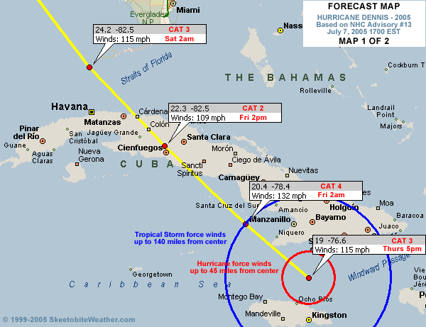
You can kind of see the ridge east of florida in this image. If it builds westward it could either force the storm more westward, or trap it to let it meander a bit and then escape to the Northeast. If it weakens or receeds, it would allow for more easterly movement. It's all speculation though. I'm not one of the Mets (Sky Blue names now!) so I'm out of my leauge on this talk.
Image here
| twizted sizter |
| (Weather Guru) |
| Thu Jul 07 2005 11:40 PM |
|
|
If..if..it crosses key West...based on some of these model runs...Fl could be looking at 3 hits possibly...the keys, somewhere west central Fl, & then somewhere Panhandle.
Not wish/fearcasting...just making an observation.
| Storm Hunter |
| (Veteran Storm Chaser) |
| Thu Jul 07 2005 11:40 PM |

|
|
|
20050707H1 Aircraft 42RF
Dennis flight 2005
The NOAA N43RF will fly a mission into Hurricane Dennis in conjunction with the NASA ER2 aircraft . The P3 will leave San Jose, Costa Rica at 11:00 PM EDT and will recover at San Jose at 8:00 AM EDT the next day.
NOAA and AF flight plans---- with NASA too
just in:
pressure down...eyewall reopened
URNT12 KNHC 072333
VORTEX DATA MESSAGE
A. 07/23:06:20Z
B. 19 deg 17 min N
077 deg 01 min W
C. 700 mb 2689 m
D. NA kt
E. NA deg nm
F. 324 deg 093 kt
G. 198 deg 009 nm
H. 951 mb
I. 11 C/ 3060 m
J. 17 C/ 3042 m
K. 12 C/ NA
L. OPEN SW
M. E36/20/16
N. 12345/ 7
O. 0.03 / 1 nm
P. AF304 0404A DENNIS OB 31
MAX FL WIND 121 KT E QUAD 21:04:50 Z
| richg |
| (Verified CFHC User) |
| Thu Jul 07 2005 11:41 PM |
|
|
From the previous thread: Here's an explanation of the -51C dewpoint in the RECCO:
97779 23074 51250 91100 88400 99005 78//8 /6973
RMK AF300 0604A DENNIS OB 11
DEW POINT NEG 51C.
In re: to the 78//8 group:
TTTdTdw
TT is the temperature in Celsius. If the temperature is negative, 50 is added to the absolute value of the temperature, and any hundreds digits are omitted. For example, a temperature of -12 would be coded as 62 (12+50 = 62) To determine if a temperature of "10" is really +10 or -110, see the indicator number in the time group above. Missing temperatures are coded as //.
TdTd is the dewpoint at flight level. Dewpoints are encoded the same as temperature. When the dewpoint is colder than -49.4C, it is reported as // and a plain language remark is added with the actual dewpoint, i.e. DEW POINT M53C. // is also reported if the dewpoint is too dry to measure accurately, or missing.
| Jeffmidtown |
| (Weather Guru) |
| Thu Jul 07 2005 11:43 PM |
|
|
|
|
The Weather Channel reports on the 8pm advisory Dennis' pressure has dropped to 951mb and sustained winds are at 130mph....more to come
| Southern4sure |
| (Weather Guru) |
| Thu Jul 07 2005 11:43 PM |

|
|
|
Quote:
You can kind of see the ridge east of florida in this image. If it builds westward it could either force the storm more westward, or trap it to let it meander a bit and then escape to the Northeast. If it weakens or receeds, it would allow for more easterly movement. It's all speculation though. I'm not one of the Mets (Sky Blue names now!) so I'm out of my leauge on this talk.
Image here
Sorry to ask but what should I be looking for to barely see the ridge? I have studied this image and I cant make heads or tails.
Thanks!
| Rich B |
| (British Meteorologist) |
| Thu Jul 07 2005 11:44 PM |
|
|
Dennis does seem to be having a bit of difficulty in maintaining a closed eye, with the latest recon indicating that it is open to the SW, and also elongated. This could be due to interference / interaction with both the landmass of Jamaica, and the vicinity of southeast Cuba. Regardless, with pressure down and an earlier flight level wind of 139mph, i think Dennis will be approaching Cat4 within the next few hours. Despite his eye problems, he is a very well organised and structured hurricane.
| Brett |
| (Weather Watcher) |
| Thu Jul 07 2005 11:44 PM |
|
|
WOW..130? Rough. Big pressure drop. Earlier today I posted about the ULL...it could indeed be eroding the high to the east. This was my concern...
| Colleen A. |
| (Moderator) |
| Thu Jul 07 2005 11:45 PM |

|
|
|
I saw your earlier question about -51 degrees C. What that means (as Storm Hunter explained) is that it is cold. I think what it ALSO means is that the colder the clouds are, the stronger the storm.
Anyone feel free to correct me if this is not right. (I'm beginning to hate the word "right".)
| Terra |
| (Storm Tracker) |
| Thu Jul 07 2005 11:48 PM |
|
|
Quote:
In re: to the 78//8 group:
TTTdTdw
TT is the temperature in Celsius. If the temperature is negative, 50 is added to the absolute value of the temperature, and any hundreds digits are omitted. For example, a temperature of -12 would be coded as 62 (12+50 = 62) To determine if a temperature of "10" is really +10 or -110, see the indicator number in the time group above.
That's a really weird convention... but, that still makes no sense.... -51 would be 51+50=101? Maybe I'm missing something?
| Southern4sure |
| (Weather Guru) |
| Thu Jul 07 2005 11:48 PM |
|
|
|
|
Quote:
I saw your earlier question about -51 degrees C. What that means (as Storm Hunter explained) is that it is cold. I think what it ALSO means is that the colder the clouds are, the stronger the storm.
Anyone feel free to correct me if this is not right. (I'm beginning to hate the word "right".)
Thank you for putting it in words that I can understand....

| Terra |
| (Storm Tracker) |
| Thu Jul 07 2005 11:51 PM |
|
|
A tiny bit more long movement over the last three hours than lat movement...
0.4 lat, 0.5 long...
| Brett |
| (Weather Watcher) |
| Thu Jul 07 2005 11:51 PM |
|
|
The 18Z GFS is scary. Takes the storm nearly directly over Key West, and then up through to the panhandle at the Alabama border. Any mets out there care to comment on the terrain in Cuba affecting this powerful storm if it keeps chugging due NW? Doesn't it bode well for weakening?
| G. J. |
| (Weather Watcher) |
| Thu Jul 07 2005 11:51 PM |

|
|
|
Will somebody be posting the figures tonight at midnight... I read on another thread that that's when the planes(or data from the planes?) will be in concerning how the trough will affect Dennis' path.
By the way, since this is my first post, beers are on me

| Storm Hunter |
| (Veteran Storm Chaser) |
| Thu Jul 07 2005 11:53 PM |
|
|
|
|
http://uap-www.nrl.navy.mil/dynamics/html/er2.gif
here's a link to one of nasa ER2 aircraft..usually they fly really HIGH, above G4's i think.... a lot of research is being put into the storm.... flights today and friday will cover the whole GOM and east side of florida and around the storm....so i would expect tonight the models with today's dropsonde data would have a pretty good handle on the storm.
side note:
The NASA ER2 aircraft is flown solo at 20 km and carries a suite
of instruments similar to those on satellites. The CV-580 and ER2
were often operated simultaneously below the TERRA satellite and
above instrumented ground sites for validation of satellite measurements.
| Southern4sure |
| (Weather Guru) |
| Thu Jul 07 2005 11:53 PM |
|
|
|
|
Quote:
Will somebody be posting the figures tonight at midnight... I read on another thread that that's when the planes(or data from the planes?) will be in concerning how the trough will affect Dennis' path.
By the way, since this is my first post, beers are on me
Im suppose to be going to a Hawiian party tomorrow night...guess it will turn into a hurricane party instead....cheers!
| Unregistered User |
| (Unregistered) |
| Thu Jul 07 2005 11:58 PM |
|
|
Was this huge drop in pressure and increase in winds expected?
| Ron Basso |
| (Storm Tracker) |
| Thu Jul 07 2005 11:59 PM |
|
|
|
|
Quote:
You can kind of see the ridge east of florida in this image. If it builds westward it could either force the storm more westward, or trap it to let it meander a bit and then escape to the Northeast. If it weakens or receeds, it would allow for more easterly movement. It's all speculation though. I'm not one of the Mets (Sky Blue names now!) so I'm out of my leauge on this talk.
Image here
I think most of the guidance indicates a weakening/eastward shift of the bermuda ridge. The UKMET model seems to be an outlier now compared to the GFDL, FSUMM5, GFS, NOGAPS, & Canadian. The european model is the only one now showing a stronger ridge & thus it pushes the storm more NW into NO. While the ridge appears to be weakening, the track of Dennis will tend to slide along its western perhipery. I don't see anything that causes the ridge to completely collaspe or be shoved dramtically eastward - such as a large mid-latitude trof. So the storm will likely "turn" north at some point, not hook NE like Charley. Where it turns north of course is the million dollar (or should I say billion dollar question). Current trends suggest somewhere west of key west but it could be as far east as the middle keys, which would drive it northward up the center of the peninsula.
| PolkBB |
| (Verified CFHC User) |
| Fri Jul 08 2005 12:00 AM |
|
|
Looks like the southern coast of Cuba is getting hammered now.
| Lysis |
| (User) |
| Fri Jul 08 2005 12:01 AM |

|
|
|
Does JB think that it is still going to hit extreme Western Cuba anymore?
| Unregistered User |
| (Unregistered) |
| Fri Jul 08 2005 12:03 AM |
|
|
Sorry I am at the in-laws, but I wanted to post and say that I am leaning more and more towards a Florida landfall, but I'm not ready to rule anything east of Grand Isle. I feel so bad for you guys over there in Florida, especially seeing the way Dennis is bombing out. It's hard to believe that such an amzing storm is out there and it's July 7. I can only hope for the best and pray for you guys over there, because if it comes in anywhere near where the current projection is then the same people who suffered for Ivan will suffer again. It's just not fair.
Anyway, back to Dennis. The storm is really something and at this point the sky is the limit. Remember, just because it goes over Cuba doesn't mean it's going to weaken that much. A hurricane I studied a lot growing up because I lived it was Elena '85 and I distinctly remember it's pressure dropping some 10MB while it traveled over Cuba. I am going to be interested to see the effect the land mass of Cuba has on the storm and to see if Dennis tries to bounce off and ride the southern coast.
Again, while I am happy for myself and my property in New Orleans, I feel for you guys in Florida. Good luck, again.......it looks like you are going to need a lot of it.

| StormHound |
| (Weather Guru) |
| Fri Jul 08 2005 12:05 AM |
|
|
Quote:
Was this huge drop in pressure and increase in winds expected?
Yes and no. Dennis was expected to keep strengthening until he hit Cuba, but this is probably stronger than most ventured to guess. Cuba will weaken Dennis, as I'm pretty sure he'll hit some mountains, but he'll be able to crank back up again once he gets out the other side. We're looking at Dennis probably hanging around Cat 3 or 4 status through his Gulf trip. Coupled with his large size, this is very bad news indeed.
| Unregistered User |
| (Unregistered) |
| Fri Jul 08 2005 12:07 AM |
|
|
What happens to Recon Flights while Dennis is over Cuba, will they stop outright until it passes?
| Colleen A. |
| (Moderator) |
| Fri Jul 08 2005 12:08 AM |
|
|
|
|
ROFLOLOL, Lysis....that was golden. I saw him at 3:30pm today he was still saying it was going to be just skirting the coast of Cuba, head to the central GOM and hit somewhere between NO and MS. I almost fell off my chair.
| nl |
| (Storm Tracker) |
| Fri Jul 08 2005 12:08 AM |

|
|
|
any reports in jamaica yet?

| Brett |
| (Weather Watcher) |
| Fri Jul 08 2005 12:10 AM |
|
|
Serious matter here. Dennis is still moving NW at 15, but it is now at 130mph, hurricane force winds out to 45 miles. Thoughts go out to those in SE Cuba, and lets keep our fingers crossed this thing jogs west and keeps its worst weather from Key West.
| Storm Hunter |
| (Veteran Storm Chaser) |
| Fri Jul 08 2005 12:11 AM |
|
|
|
|
the center of the storm is starting to show up on Cienfuegos radar (near center of country)...looks like the little tip that sticks out on south cuba is getting hammered right now.... but looks like the eye will stay offshore until late friday when dennis crosses cuba...
this link is starting to slow down....meaning web site is getting a lot of traffic.... try this link
Cienfuegos
if that does not work try here
radar single
trying to translate spanish, its been sometime now, but i think i read a report of winds sustained near 60mph in a southern city of cuba with gust to 82mph, within the last hour
| Colleen A. |
| (Moderator) |
| Fri Jul 08 2005 12:12 AM |
|
|
|
|
I don't remember if I read this on MidAtlanticWX or in one of the discussions from NHC, but I DO remember reading that it could get down as low as 931mb. The way we're going, we might hit that tonight.

| Lysis |
| (User) |
| Fri Jul 08 2005 12:13 AM |
|
|
|
|
While I am not sure... I see no reason as to why they would stop recon while the cyclone is over land, however I am not sure if they would fly one at night. Actually, It guess it is mostly instrument flying anyway, so I imagine they could do even that.
| richg |
| (Verified CFHC User) |
| Fri Jul 08 2005 12:13 AM |
|
|
Quote:
What happens to Recon Flights while Dennis is over Cuba, will they stop outright until it passes?
Their flights will be limited somewhat. The US military is forbidden from flying in Cuban airspace except for certain routes(i.e approaches to GITMO.)
| Lysis |
| (User) |
| Fri Jul 08 2005 12:15 AM |
|
|
|
|
... right, that makes sense.
EDIT: Storm Hunter, thank you for that link. I have been wanting a cuban radar site all day.
| Storm Hunter |
| (Veteran Storm Chaser) |
| Fri Jul 08 2005 12:15 AM |
|
|
|
|
recon flights will fly around cuba until the storm exits coast....like charley did last year, the min the storm exits the coast, an AF aircraft will most likely enter the center..... the NOAA and NASA flights will be all the way around the storm (ALL DAY)
|
danielw
|
| (Moderator) |
| Fri Jul 08 2005 12:16 AM |

|
|
|
Terra has the right idea. Just take a sheet of paper and right down the coordinates on each advisory. Graph paper works great. Do the math and you can see the smaller jogs this way and that way.
Don't forget to watch the Advisories though. And don't get stuck on "the skinny black line".
If you are in the "Cone", make sure that you are ready to leave as soon as your area is asked to leave.
| Lysis |
| (User) |
| Fri Jul 08 2005 12:17 AM |
|
|
|
|
Yes, this season we got a big waterproof chart of the Caribbean, Gulf, and northwest Atlantic. Tracking them by hand is much more... intimate. I highly recommend it.
| FlaMommy |
| (Storm Tracker) |
| Fri Jul 08 2005 12:17 AM |

|
|
|
can someone please inform me whether tampa is still in the cone ....my mother in law saw on tv that we are out of the cone....i want to prove her wrong....she said shes not evacuating if we have to...well she lives with us and if need be my husband, daughter and myself will be leaving....

| Unregistered User |
| (Unregistered) |
| Fri Jul 08 2005 12:18 AM |
|
|
Problem with JB is he's stubborn as a mule. Once he makes up his mind he'll devise a scenaio in his head as to how it will happen (AKA, drinking you're own bath water). On the other hand, don't dismiss the possibility that after the Keys Dennis may turn to the WNW. It is possible. I don't buy it, but this is a tough one!! Like Ed D. said earlier, he's rounding the subtropical ridge and will eventually take a NNW trajectory. That is IF the high in the plains doesn't suppress and couple with a building ridge in the Western Atlantic. I personally don't see any ridge building there right now. Just a small surface ridge petering out off the east coast. Time will tell the tale, but NO this won't exit the western tip of Cuba....utter nonsense. He has slowed to a crawl though

| Storm Cooper |
| (User) |
| Fri Jul 08 2005 12:21 AM |
|
|
http://www.nhc.noaa.gov/refresh/graphics_at4+shtml/205500.shtml?3day
This is what you want to look at as far as the cone and keep checking www.nhc.gov for updates
Also the left side of our main page will show you this...but always check the NHC.
| Unregistered User |
| (Unregistered) |
| Fri Jul 08 2005 12:21 AM |
|
|
The other Rule #1: Never try to prove your mother-in-law wrong!!!!!!!!!!!
| Rasvar |
| (Weather Master) |
| Fri Jul 08 2005 12:22 AM |

|
|
|
You can see the official cone here. http://flhurricane.com/cyclone/stormspotlight.php?year=2005&storm=4
| Ron Basso |
| (Storm Tracker) |
| Fri Jul 08 2005 12:22 AM |
|
|
|
|
Quote:
can someone please inform me whether tampa is still in the cone ....my mother in law saw on tv that we are out of the cone....i want to prove her wrong....she said shes not evacuating if we have to...well she lives with us and if need be my husband, daughter and myself will be leaving....
Go to the NHC link: the cone extends into west-central FL
http://www.nhc.noaa.gov/refresh/graphics_at4+shtml/205500.shtml?3day
| FlaMommy |
| (Storm Tracker) |
| Fri Jul 08 2005 12:22 AM |
|
|
|
|
believe me she doesnt scare me...;)...hehe....we are both pisces we butt heads alot....lol
| Unregistered User |
| (Unregistered) |
| Fri Jul 08 2005 12:22 AM |
|
|
Colleen and Lysis,
No offense meant as I know you both know alot more tha me but...
If N.O. is still in the cone, don't people still need to be prepared. I'm not saying he's right at all but but I don't think its right to say N.O. is in the clear till its out of the cone.
Sorry...just wanted to voice that.
| Colleen A. |
| (Moderator) |
| Fri Jul 08 2005 12:25 AM |
|
|
|
|
Brett...sorry if it sounded like I wasn't taking this seriously. I am, believe me. I went through all 3 storms last year with the exception of IVAN and I am not looking forward to another one.
Just every once in a while, though, it's good for the soul to laugh out loud.
| Brett |
| (Weather Watcher) |
| Fri Jul 08 2005 12:26 AM |
|
|
Of course, you are right. N.O. is not in the clear by any means, and I doubt that is what Colleen meant. The point is that we all need to keep a close eye...the next 12 hours are crucial. Any mets out there with comments on the surrounding atmospherinc trends? Is the high holding up?
| stormchazer |
| (Storm Tracker) |
| Fri Jul 08 2005 12:27 AM |

|
|
|
Quote:
Colleen and Lysis,
No offense meant as I know you both know alot more tha me but...
If N.O. is still in the cone, don't people still need to be prepared. I'm not saying he's right at all but but I don't think its right to say N.O. is in the clear till its out of the cone.
Sorry...just wanted to voice that.
If you are in the GoM coast from LA east, be prepared. The jury is still out.
| Unregistered User |
| (Unregistered) |
| Fri Jul 08 2005 12:27 AM |
|
|
After the drama last year, I would strongly suggest any people living up the west coast and around the pan handle to fill up NOW and not wait. The gas stations seem to always run out of gas real early.
I'm also convinced that this storm is either wobbling or turning more NNW than NW, any thoughts?
| Terra |
| (Storm Tracker) |
| Fri Jul 08 2005 12:27 AM |
|
|
97779 23074 51250 91100 88400 99005 78//8 /6973
RMK AF300 0604A Dennis OB 11
DEW POINT NEG 51C.
Someone sent me a link and I tried to decode this manually....
97779 It says this report was made by an aircraft with radar capability.
23074 It was done on 7/7 at 23:07 UTC (7:07 PM EST) with dewpoint capability with the aircraft below 10000 m.
51250 91100 It was done on Thursday with the aircraft located at 25.0 N and 91.1 W Boy, that makes no sense... maybe they meant 71.1 W (The 91100 part can't be)? There was no turbulance and the conditions were clear.
84400 The pressure altitude of the aircraft was 884 decameters... (what a useful unit, huh?) which is... well, not the same as meters as this website implies, so I'm confused again. 884 decameters would be 8840 meters and 29k feet. The wind is spot wind, which was obtained using dopplar radar or inertial systems.
99005 Again, this makes no sense... the 99 should represent the wind direction, but you have to add a zero after it, and well, 990 is silly... and that would also mean the windspeed was 5 kts... It can't be the temperature either, as 99 C would be insane, too. So, it seems I am stuck, and the 78//8 part makes no sense either.
/6973 This indicated a pressure group. It was done at the 300 mb level in geopotential decameters (huh? I get the 300mb part, but what does geopotential decameters mean?) Sealevel pressure is 973 mb.
I didn't even make it to the dew point part, since the temp data seems messed up... Where did I go wrong?
Edited to apologize for my need to understand everything I read....
P.S. That link, http://www.hurricanehunters.com/recco.htm says a language remark can be added to state the actual dew point... So, that brings us back to a negative dew point... Again, dew point is the temp required for saturation... something that shouldn't be negative in a storm.
| Brett |
| (Weather Watcher) |
| Fri Jul 08 2005 12:28 AM |
|
|
No worries Colleen! I can appreciate lightening things up a bit. I just wish we had a better handle on things. Anyone else remember a storm with such frequently shifting models?
| Storm Cooper |
| (User) |
| Fri Jul 08 2005 12:29 AM |
|
|
Most all of them
| Ron Basso |
| (Storm Tracker) |
| Fri Jul 08 2005 12:30 AM |
|
|
|
|
Quote:
I don't remember if I read this on MidAtlanticWX or in one of the discussions from NHC, but I DO remember reading that it could get down as low as 931mb. The way we're going, we might hit that tonight.
Pressure now 951 mb (28.02) - Dennis is quickly approaching the pressure of Hurricane Opal (min. 942 mb, 27.82) - after that it wont have far to go to pass Hugo (934 mb, 27.54) - of course, if it gets to 922 mb, we can put our head between our knees & .......... 922 mb was Andrews Min Pressure
| Colleen A. |
| (Moderator) |
| Fri Jul 08 2005 12:30 AM |
|
|
|
|
I didn't say that N.O. is in the clear...what I SHOULD have said is that his idea that it will skirt the entire coast of Cuba (missing land entirely) going WNW was simply ridiculous. He might be a good met, but to be that far away from the official NHC track is a little absurd.
No offense taken, BTW. Just state things as I see them.
| pcola |
| (Storm Tracker) |
| Fri Jul 08 2005 12:31 AM |

|
|
|
Tried to fill up here in Pcola (Gulf Breeze) and most stations were out of gas waiting on trucks.
| Frank P |
| (Veteran Storm Chaser) |
| Fri Jul 08 2005 12:31 AM |
|
|
Use the link posted by stormhunter on the Cuba radar loop...
http://www.met.inf.cu/Radar/03Cienfuegos/cienfuegosa.gif
and you can see for yourself what direction he is going...
| Storm Hunter |
| (Veteran Storm Chaser) |
| Fri Jul 08 2005 12:31 AM |
|
|
|
|
pretty picture few hours ago
http://www.esl.lsu.edu/quicklinks/hurricanes/2005/DENNIS/images/050707.1542.t01.jpg
| Unregistered User |
| (Unregistered) |
| Fri Jul 08 2005 12:32 AM |
|
|
sorry..its just that we are taking this seriously in N.O. until we are sure that its not coming.
Its scary to think of all the people who simply couldnt leave and would be in great danger.
I'm praying it doesnt come here and that by some chance of fate this monster slows down before harming anyone!
btw..still can't login for some reason
| MC Hurricane |
| (Registered User) |
| Fri Jul 08 2005 12:34 AM |
|
|
I just could not believe that Dennis had strengthened that much. It really surprised me to find out that it was that strong.
By the way i'm not new. For a while I was unregistered going by the name hurricanekid. I am praying for the people of Cuba having to go through what maybe a category four at landfall.
| Bev |
| (Weather Guru) |
| Fri Jul 08 2005 12:38 AM |

|
|
|
Quote:
<snip>
If you are in the "Cone", make sure that you are ready to leave as soon as your area is asked to leave.
There is something that has not been addressed but certainly needs to be. By all emergency management personnel and those on this board. Everyone advises evacuation. Get out of the path of the storm! Well.... exactly how to do that is really one great big unknown unless one evacuates in time to reach middle Georgia, and the orders for evacuation are never given in time for all of us in county after county to reach middle Georgia. Traffic slows to a crawl and we're all stuck on the roads in the middle of a hurricane.
Scenario: Evacuation orders are given for county after county in SW FL.
Problem: Mets have absolutely no idea where the hurricane is actually going to go until it gets there. Case in point - Charley.
Scenario: I put plywood on all my windows, pack up and head inland, 1.5 hours from the coast, where there is no evacuation order because the hurricane is not "supposed" to go there..
Scenario: I take shelter in a home where windows are not boarded because the hurricane is not expected to reach there. Hurricane decides at the last moment to head away from where it was heading and make a turn my direction. I am now vulnerable, no plywood on windows, no generator, no water, no food supplies. Cat 4 winds roar overhead, huge oaks crashed around us, the roof peeled up, windows rattled and closet doors slammed of their own accord and I wondered why I left my boarded up, generator-ready, food-filled home to end up stranded in what became a complete disaster area.
I guess my point is this.... Do NOT expect evacuation orders given by emergency management officials to keep you out of harm's way. Hurricanes just don't work like that. My advice, from having experienced the exact scenario above is to protect yourself where you are unless you have a VERY good reason for being elsewhere. i.e. You live in a mobile home.
-Bev
Edited by Moderator. Lets be careful about what we say and how we say it.
| Storm Hunter |
| (Veteran Storm Chaser) |
| Fri Jul 08 2005 12:38 AM |
|
|
|
|
AF304 heading home
AF300 be there for another 2-3hrs and
AF307 on there way...
did i mention that NOAA and NASA have one plane each out there now too

looks like the eye will be making landfall shortly on that tip on southern cuba, then it appears that dennis will ride the cuban coast late tonight into morning, until making landfall again in mid morning farther north on the coast.
| twizted sizter |
| (Weather Guru) |
| Fri Jul 08 2005 12:39 AM |
|
|
Besides all of them..LOL... remember Jeanne as she spun in circles & everyone...except the good people here...wrote her off until the last minute...never forget Jebs face when a camera crew asked him about it.
Even as she treked across & they insisted on that turn north...while I felt the foundation of my house shake...
| Terra |
| (Storm Tracker) |
| Fri Jul 08 2005 12:39 AM |
|
|
LA people... read my post regarding the contaflow potential disaster on the last page of the previous forum.... Seriously, I don't believe it is going to work as well as some people hope! I'm hoping we don't have to try it, but guys, if we do... be prepared and go early.
| MC Hurricane |
| (Registered User) |
| Fri Jul 08 2005 12:41 AM |
|
|
Earlier Dennis' track was very similar to Ivan's track. The projected path looks similar to the track of Charley. Afterwards it looks like the track of Ivan again.
Hopefully it will not be as strong as Charley or Ivan at landfall.

| FlaMommy |
| (Storm Tracker) |
| Fri Jul 08 2005 12:42 AM |
|
|
|
|
i am sure this wasnt meant to be rude...but it kinda sounds a little rude....just because some people live in mobile homes "isnt" by choice....i would love to not live in a mobile home but unfortunately im not as fortunate as others who have a strong sturdy house....so im sorry i seem to snap at that but having your head examined, because you have no choice but to live in a mobile home....sorry....
|
danielw
|
| (Moderator) |
| Fri Jul 08 2005 12:43 AM |
|
|
|
|
Middle Georgia is probably a good place right now. Anywhere in the Interstate 20 neighborhood.
With an exception. TD Cindy wrecked parts of AL and GA. So make sure before you go.
All lodging in Hattiesburg, MS is full due to mobilization of troops. So I can save you a few phone calls here.
I'll put some more info in the Disaster Forum.
By the way...gas prices in Hattiesburg/ Laurel,MS have gone up as much as 20 cents today.
| Storm Hunter |
| (Veteran Storm Chaser) |
| Fri Jul 08 2005 12:44 AM |
|
|
|
|
looking at this link
http://www3.dot.state.fl.us/trafficinformation/
traffic is starting to pick up along the west side of florida, will be watching the panhandle and expect friday will be busy..... click the little boxes on image
gas in PCB is around $2.35 today... many stations are running out now... saw gas jump 15 cents in one hour.....thanks to cindy!
| Unregistered User |
| (Unregistered) |
| Fri Jul 08 2005 12:44 AM |
|
|
have u seen the latest images Dennis appers to be heading a little more north do u agree or have i had to many beers!
| Unregistered User |
| (Unregistered) |
| Fri Jul 08 2005 12:47 AM |
|
|
I alluded to the NNW movement earlier and they pointed me to the Cuban Radar link which in my opinion has poor visibility
| nl |
| (Storm Tracker) |
| Fri Jul 08 2005 12:48 AM |
|
|
|
|
i was getting ready too say it too i notice and ive been watching for at least 50 minutes.
look out miami!
| Bev |
| (Weather Guru) |
| Fri Jul 08 2005 12:50 AM |
|
|
|
|
Quote:
i am sure this wasnt meant to be rude...but it kinda sounds a little rude....just because some people live in mobile homes "isnt" by choice....i would love to not live in a mobile home but unfortunately im not as fortunate as others who have a strong sturdy house....so im sorry i seem to snap at that but having your head examined, because you have no choice but to live in a mobile home....sorry....
My apologies, no offense meant. I just would not try to ride out any category hurricane in a mobile home, so I certainly wouldn't recommend it to anyone else.
The fact that mobile homes are still allowed in Florida just boggles my mind. If they weren't allowed, then you would not be forced to live in one. Smaller, less expensive, but well-built homes are a much better and affordable alternative.
Even the brand new, so-called "hurricane-proof" mobile homes were ripped to shreds during Charley. I still have photos I took myself. Even the rambling shacks of old homes fared much better than the spanking new mobile homes. It was heart-rending to see.
Best Regards,
Bev
|
danielw
|
| (Moderator) |
| Fri Jul 08 2005 12:50 AM |
|
|
|
|
HURRICANE DENNIS INTERMEDIATE ADVISORY NUMBER 13A
NWS TPC/NATIONAL HURRICANE CENTER MIAMI FL
8 PM EDT THU JUL 07 2005 Edited
http://www.srh.noaa.gov/data/NHC/TCPAT4.0507072338
A HURRICANE WARNING IS IN EFFECT FOR THE LOWER FLORIDA KEYS FROM THE
SEVEN MILE BRIDGE WESTWARD TO THE DRY TORTUGAS...AND A TROPICAL
STORM WARNING IS IN EFFECT FOR THE REMAINDER OF THE FLORIDA
KEYS...EAST OF THE SEVEN MILE BRIDGE TO OCEAN REEF AND FLORIDA BAY.
A HURRICANE WATCH REMAINS IN EFFECT FOR THE FLORIDA KEYS EAST OF
THE SEVEN MILE BRIDGE TO OCEAN REEF AND FLORIDA BAY
A HURRICANE OR TROPICAL STORM WARNING MEANS THAT HURRICANE OR
TROPICAL STORM CONDITIONS...RESPECTIVELY...ARE EXPECTED WITHIN THE
WARNING AREA WITHIN THE NEXT 24 HOURS. PREPARATIONS TO PROTECT LIFE
AND PROPERTY SHOULD BE RUSHED TO COMPLETION IN THE HURRICANE
WARNING AREA.
A TROPICAL STORM WATCH IS IN EFFECT FOR ALL OF THE SOUTHERN FLORIDA
PENINSULA FROM GOLDEN BEACH SOUTHWARD ON THE EAST COAST AND SOUTH
OF BONITA BEACH ON THE WEST COAST. WATCHES AND WARNINGS ALONG BOTH
THE EAST AND WEST COASTS OF FLORIDA WILL LIKELY BE EXTENDED
NORTHWARD LATER THIS EVENING.
| Terra |
| (Storm Tracker) |
| Fri Jul 08 2005 12:50 AM |
|
|
Quote:
i was getting ready too say it too i notice and ive been watching for at least 50 minutes.
Which radar are you looking at? The ones on the NHC page are updated every 30 minutes, so you may only be seeing one or two points... Could be a jog, could be real, give it a few hours and then you can tell.
| Unregistered User |
| (Unregistered) |
| Fri Jul 08 2005 12:51 AM |
|
|
Yea the cuban radar isnt showing much info at the minute i got a bad feeling about this one im just glad i dont live on the water theres gonna be a nasty storm surge 6 ft+ i reckon.
| Unregistered User |
| (Unregistered) |
| Fri Jul 08 2005 12:53 AM |
|
|
I would opine that the movement appears to me, to be moving somewhat move northward than earlier...pursuant to the last 2-3 hours of film
| RedingtonBeachGuy |
| (Moderator) |
| Fri Jul 08 2005 12:55 AM |
|
|
"My advice, from having experienced the exact scenario above is to protect yourself where you are unless you have a VERY good reason for being elsewhere. i.e. You live in a mobile home. "
I TOTALLY disagree with this advice. I have been thru a ton of cains since the 60's down here in Florida and I can tell everyone that it is ALWAYS better to evacuate A and B zones than to ride it out. In one cain in the 60's, we were told to evacuate and didn't.. it was just a Cat 3 we said. We sat thru the winds but didn't expect 15' high walls of water to come cascading down on us 1/2 mile from the Gulf of Mexico. Eventually we were under 9 feet of water on the island.
My point is, while some say they have riden storms out, they have been LUCKY. Don't risk your life - follow emergency management's decision for your area. and zone.
| MC Hurricane |
| (Registered User) |
| Fri Jul 08 2005 12:56 AM |
|
|
Quote:
have u seen the latest images Dennis appers to be heading a little more north do u agree or have i had to many beers!
No. Dennis does look like it is heading north.
| Hurricane Fredrick 1979 |
| (Weather Guru) |
| Fri Jul 08 2005 12:56 AM |

|
|
|
Does anyone know why the NHC ftp model site has not updated dennis since the 06Z run? I been waiting all day on the model runs but it is still showing the 06Z runs.
| Storm Hunter |
| (Veteran Storm Chaser) |
| Fri Jul 08 2005 12:58 AM |
|
|
|
|
West-Bound Counter 0156 on I-10 in ESCAMBIA County, near ALABAMA LINE
is showing many vehicles heading west and already beating Historical Average!!!!
west bound on 1-10 right now is over 1100 VPH (Vehicles Per Hour)....
| Unregistered User |
| (Unregistered) |
| Fri Jul 08 2005 12:58 AM |
|
|
i just checked the last load of waypoints theres been a more northward trend in Dennis but not enogh for it to hit MIA not direcly anyway!
| Lake Toho - Kissimmee |
| (Storm Tracker) |
| Fri Jul 08 2005 12:59 AM |

|
|
|
Looks like many of the models moved west again.. LOL..But they all appear to have a consenus of Florida/Alabama Line. So hey maybe they are on to something.. then again, maybe not..
| StormHound |
| (Weather Guru) |
| Fri Jul 08 2005 01:01 AM |
|
|
Quote:
"My advice, from having experienced the exact scenario above is to protect yourself where you are unless you have a VERY good reason for being elsewhere. i.e. You live in a mobile home. "
I TOTALLY disagree with this advice. I have been thru a ton of cains since the 60's down here in Florida and I can tell everyone that it is ALWAYS better to evacuate A and B zones than to ride it out. In one cain in the 60's, we were told to evacuate and didn't.. it was just a Cat 3 we said. We sat thru the winds but didn't expect 15' high walls of water to come cascading down on us 1/2 mile from the Gulf of Mexico. Eventually we were under 9 feet of water on the island.
My point is, while some say they have riden storms out, they have been LUCKY. Don't risk your life - follow emergency management's decision for your area. and zone.
I cannot agree more with Red. Every 50 miles inland is a huge difference in terms of hurricane strength. While the hurricanes caused much distruction in Central Florida, it was generally not life threatening. Even without the windows boarded up, you can ride out a storm in a small-windowless room in the center of the house. It is much better to be in a house which has lost shingles and has water coming in, then a house without a roof or walls. If ordered to evacuate, do so.
| BillD |
| (User) |
| Fri Jul 08 2005 01:02 AM |
|
|
It might have been correct. They do post observations on their way to their destination, and on the way back, so everyone can keep tabs on where they are. These planes fly out of locations around the SE US and the Caribbean, so it is not unusual to see coordinates far away from the storm, but usually right at the beginning of a run or end..
Bill
| Tazmanian93 |
| (Weather Master) |
| Fri Jul 08 2005 01:03 AM |

|
|
|
Actaully, I have been watching all 6 of those models and 4 panel for CMC and as of right now, nothing from most of the perspectoves has changed since Dennis was named.
| StormHound |
| (Weather Guru) |
| Fri Jul 08 2005 01:03 AM |
|
|
Quote:
i just checked the last load of waypoints theres been a more northward trend in Dennis but not enogh for it to hit MIA not direcly anyway!
Even if it did hit Miami somehow, it would have traveled across the state of Florida to get there. Miami would be looking at something less than full strength Hurricane Dennis.
| Old Sailor |
| (Storm Tracker) |
| Fri Jul 08 2005 01:03 AM |

|
|
|
Latest NHC Model run....
web page
| pcola |
| (Storm Tracker) |
| Fri Jul 08 2005 01:04 AM |
|
|
|
|
As a Pensacola resident, I can say nothing is so frightening as seeing Jim Cantore from the weather channel on Pensacola Beach....he is here again!
| twizted sizter |
| (Weather Guru) |
| Fri Jul 08 2005 01:05 AM |
|
|
Yeah they all seem pretty set...guess it's just who the winner/loser is.
| Bev |
| (Weather Guru) |
| Fri Jul 08 2005 01:05 AM |
|
|
|
|
Quote:
"My advice, from having experienced the exact scenario above is to protect yourself where you are unless you have a VERY good reason for being elsewhere. i.e. You live in a mobile home. "
<snip>....My point is, while some say they have riden storms out, they have been LUCKY. Don't risk your life - follow emergency management's decision for your area. and zone.
You missed my point entirely. My point was that you just might have to "ride it out" no matter where you evacuate to, so you should be prepared to do exactly that, whether you stay where you are or flee to a county that isn't even under an evacuation order.
I fled because they told me to flee. The windspeed where I fled from never got above 40 mph. I went where they told me to go. There, the windspeed was 140 mph.
That's my point, you simply cannot KNOW where you will be safe, and neither can the experts. Be prepared, prepared, prepared, wherever you are.
I wasn't trying to be brave and ride it out, I was fleeing, trying to keep my family safe. After my experience, I realize that some common sense is in order and that the "officials" don't always have a perfect handle on it.
I had hoped for intelligent discussion on how to protect yourself where you are, and not always relying on "head somewhere else". Because sometimes you can't head somewhere else, you find it on your heels despite trying to get away from it. I am not a brave advocate of "riding it out",. I'm simply a concerned mother trying to keep my family safe.
-Bev
| twizted sizter |
| (Weather Guru) |
| Fri Jul 08 2005 01:06 AM |
|
|
Usually that means where it won't go.
| javlin |
| (Weather Master) |
| Fri Jul 08 2005 01:07 AM |
|
|
Then you are lucky I thought hwere ever Jim went the Hurricane was sure not to come.If you do not want him send him our way a little insurance never hurt no one.
| Unregistered User |
| (Unregistered) |
| Fri Jul 08 2005 01:07 AM |
|
|
Any one think marco has a chance of being hit, my grandma is getting worried and is on about evacu??? i wanna stay and wacth it from the beach=]
| Lysis |
| (User) |
| Fri Jul 08 2005 01:08 AM |
|
|
|
|
uh... wow! The hurricane city broadcast keeps bieng cut in by Will and Grace (they got struck by lightning).
| Terra |
| (Storm Tracker) |
| Fri Jul 08 2005 01:08 AM |
|
|
Quote:
Any one think marco has a chance of being hit, my grandma is getting worried and is on about evacu??? i wanna stay and wacth it from the beach=]
Not a particularly good idea if it does come your way....
| Jeffmidtown |
| (Weather Guru) |
| Fri Jul 08 2005 01:09 AM |
|
|
|
|
If people are planning on evacuating into Georgia, your best bet would be anywhere on the eastern part of the state say from Macon to Augusta. The Columbus area got hit pretty hard last night as well as the southern metro counties of Atlanta.
Someone correct me if I'm wrong, or it maybe the 2 hours sleep I had last night, but if some of the models are showing Dennis to take a Florida/Alabama track, wouldn't that give it the exact same track as Ivan from last year?
If it is the case, I think I may need to re-inflate my water wings here because Atlanta can't take any more heavy rain....
| Lake Toho - Kissimmee |
| (Storm Tracker) |
| Fri Jul 08 2005 01:09 AM |
|
|
|
|
CMC Model still shows the same track.. Amazing UK MET and CMC have barely moved off their tracks.
| twizted sizter |
| (Weather Guru) |
| Fri Jul 08 2005 01:09 AM |
|
|
Your local EOC will have evac info...won't comment about you wanting to stay & watch from the beach.
| KC |
| (Weather Hobbyist) |
| Fri Jul 08 2005 01:10 AM |
|
|
Uh-oh - Jim Cantore is now live from Pensacola. Sorry, but I'm happy he isn't in Naples! Collier County Commissioners have called an emergency meeting at 8:30 am Friday morning and I'm guessing they will probably call for a state of emergency unless there is a drastic change for the better overnight. Stores were busy this afternoon but not crazy, same with gas stations. Just moved my orchids from the lanai to the bathtub (aka their summer home) so there is not as much to do tomorrow. Stay safe everyone!
Karen
Naples, FL
| Unregistered User |
| (Unregistered) |
| Fri Jul 08 2005 01:10 AM |
|
|
Quote:Quote:
Any one think marco has a chance of being hit, my grandma is getting worried and is on about evacu??? i wanna stay and wacth it from the beach=]
Not a particularly good idea if it does come your way....
LoL
| AgentB |
| (Weather Guru) |
| Fri Jul 08 2005 01:10 AM |

|
|
|
Still looks NW to me at a pretty decent rate of speed.
While a weakening of the high should allow Dennis to make a "turn". He won't exactly turn on his axis and head due north. It will still take a while for the westward component to cease.
| Frank P |
| (Veteran Storm Chaser) |
| Fri Jul 08 2005 01:13 AM |
|
|
Yeah, I don't know what Pensacola did to piss off the weather gods, but boy, I sure hope we don't do the same thing in Biloxi... this will be incredible if Pensacola takes another direct hit from a major.... models are pretty tight too, but you can still expect some minor shifts back and forth over the next two days... they might not be much but anything that puts you on the west side of this storm would be a good shift indeed.... a small wobble 100+ miles off the coast could have a dramatic effect on the exact landfall point... and whether or not you are in the dreaded eye wall... Believe me, YOU DON'T WANT TO BE IN THE EYE WALL OF A MAJOR STORM... period... all eyes will be looking really hard south in the gulf this weekend... I'll finish all my preps tomorrow... and not planning to evacuate at this time....
|
danielw
|
| (Moderator) |
| Fri Jul 08 2005 01:15 AM |
|
|
|
|
Quote:
Any one think marco has a chance of being hit, my grandma is getting worried and is on about evacu??? i wanna stay and wacth it from the beach=]
Terra beat me to it. Do Not watch the hurricane from the beach. Your Grandma has been through more severe weather than you. So do as she wants.
She didn't get to be Grandma by watching Hurricanes from the Beach.
Last year Dr Steve Lyons, of The Weather Channel, blasted several reporters for staying outside during a "Landfalling Hurricane". You can't see what is coming at you!!
| pcola |
| (Storm Tracker) |
| Fri Jul 08 2005 01:15 AM |
|
|
|
|
Why the sudden shift to the west on the models.??? I was excited about the eastward trend for us, but now most come right towards the western panhandle.
| Unregistered User |
| (Unregistered) |
| Fri Jul 08 2005 01:17 AM |
|
|
I guess the models know best... my eyes must have been playing tricks on me, and few others according to their posts
| wxman007 |
| (Meteorologist) |
| Fri Jul 08 2005 01:18 AM |
|
|
Quote:
Why the sudden shift to the west on the models.??? I was excited about the eastward trend for us, but now most come right towards the western panhandle.
These runs don't have new upper-air obs in them, other than the regular obs...there was no new dropsonde data in these runs...so remember that....
|
MikeC
|
| (Admin) |
| Fri Jul 08 2005 01:19 AM |
|
|
Quote:Quote:
Why the sudden shift to the west on the models.??? I was excited about the eastward trend for us, but now most come right towards the western panhandle.
These runs don't have new upper-air obs in them, other than the regular obs...there was no new dropsonde data in these runs...so remember that....
The next set of runs will be much more interesting. This set was pretty blah because of some of the lack of data.
| KC |
| (Weather Hobbyist) |
| Fri Jul 08 2005 01:19 AM |
|
|
Quote:
Any one think marco has a chance of being hit, my grandma is getting worried and is on about evacu??? i wanna stay and wacth it from the beach=]
Marco - watch the local governemnt channel tomorrow morning at 8:30 am - the county commissioners are having their emergency meeting with emergency management and you can find out what their plans are for evacuations. I don't think they will encourage anyone to watch the storm from the beach. Be careful!
Karen
Naples
| Frank P |
| (Veteran Storm Chaser) |
| Fri Jul 08 2005 01:19 AM |
|
|
Danny boy, I watch hurricanes from the beach in Biloxi all the time... of course I would NEVER recommend it for anyone else.... and I'm 20 feet above sea level... and I'm insane...
| Unregistered User |
| (Unregistered) |
| Fri Jul 08 2005 01:19 AM |
|
|
Sure i wont watch it from the beach if is coming directly at us {wich i doubt} but if its say 100+ miles offshore wouldent that be safe?
| Unregistered User |
| (Unregistered) |
| Fri Jul 08 2005 01:20 AM |
|
|
Quote:
As a Pensacola resident, I can say nothing is so frightening as seeing Jim Cantore from the weather channel on Pensacola Beach....he is here again!
This made me sick to see Cantore on Pcola Beach. Pcola beach will be absolutely destroyed if we take a direct hit, because there is still so much debris and demolished structures that have not yet been removed and the existing structures will be pelted and reamed by all the flying material.
Right next door to my house is a new house being built. All i can say is the builder better pick up all loose wood, etc. or i will be advertising on the PensacolaNewsJournal.com website message board the presence of free plywood to get it moved out of here.
Cantore, go elsewhere !!!!
| Terra |
| (Storm Tracker) |
| Fri Jul 08 2005 01:21 AM |
|
|
Quote:
Sure i wont watch it from the beach if is coming directly at us {wich i doubt} but if its say 100+ miles offshore wouldent that be safe?
What exactly do you expect to see at 100+ miles offshore?
| Unregistered User |
| (Unregistered) |
| Fri Jul 08 2005 01:21 AM |
|
|
Do you guys see movement more toward the north?
| Unregistered User |
| (Unregistered) |
| Fri Jul 08 2005 01:22 AM |
|
|
Uh, north? I don't think so. Dennis has been moving pretty consistently NW overall with the occasional jut north followed by one to the west. If anything, in the last six hours, he's been trending more west than north after a nine hour period in which he trended more north than west. Add it all up, and it's a pretty solid NW heading.
| pcola |
| (Storm Tracker) |
| Fri Jul 08 2005 01:22 AM |
|
|
|
|
GulfBreeze...my wife thinks Jim has a girlfriend on the beach..thats why he is always here
| Unregistered User |
| (Unregistered) |
| Fri Jul 08 2005 01:23 AM |
|
|
Er isnt this cane 200 miles across?
|
danielw
|
| (Moderator) |
| Fri Jul 08 2005 01:23 AM |
|
|
|
|
Quote:
Why the sudden shift to the west on the models.??? I was excited about the eastward trend for us, but now most come right towards the western panhandle.
"Excited"?
I don't know about 'excited' about the models pointing at me. Or anyone else here.
Probably the most agreement of the models since last night. Tight cluster. Around Jim Cantore's area-Pensacola...right now.
UKMET is the western outlier.
I noticed the Xtrapolated line moved west from Bayou La Batre,AL to Main Pass,LA.
| Lake Toho - Kissimmee |
| (Storm Tracker) |
| Fri Jul 08 2005 01:24 AM |
|
|
|
|
Agree on the BLAH !!
| rjp |
| (Verified CFHC User) |
| Fri Jul 08 2005 01:25 AM |
|
|
Quote:Seeing posts from people like this makes me think things should be restricted to registered members until things calm down. lol
Er isnt this cane 200 miles across?
| pcola |
| (Storm Tracker) |
| Fri Jul 08 2005 01:25 AM |
|
|
|
|
Excited in the sense I will not loose my home for the 2nd time in 10 months. Never would wish this on anyone..except alqueda>
| Terra |
| (Storm Tracker) |
| Fri Jul 08 2005 01:25 AM |
|
|
Quote:
Er isnt this cane 200 miles across?
Oh, you mean being 100 miles from where the eye of the storm hits land... in a lateral direction.... for some reason your post implied to me that you were going to watch the storm when it was still 100 miles off the coast...
Good point... rjp... I'll stop antagonizing.... Man, I'm bad about that today!
| Frank P |
| (Veteran Storm Chaser) |
| Fri Jul 08 2005 01:27 AM |
|
|
tracking it on Cuban radar sure looks like a solid NW to me too...
http://www.met.inf.cu/Radar/03Cienfuegos/cienfuegosa.gif
| pcola |
| (Storm Tracker) |
| Fri Jul 08 2005 01:28 AM |
|
|
|
|
What is the extrapolated line represent?
| RedingtonBeachGuy |
| (Moderator) |
| Fri Jul 08 2005 01:28 AM |
|
|
seems the models are all coming into agreement now.. things must be getting a bit more stable to predict from.
| Unregistered User |
| (Unregistered) |
| Fri Jul 08 2005 01:29 AM |
|
|
XTRAP is an extrapolated line using the current overall motion of the storm. In other words, it's where it would go if it does not change direction at all from now until landfall.
| Frank P |
| (Veteran Storm Chaser) |
| Fri Jul 08 2005 01:29 AM |
|
|
thats if it continued on its present motion without changing
| StormHound |
| (Weather Guru) |
| Fri Jul 08 2005 01:30 AM |
|
|
Quote:
You missed my point entirely. My point was that you just might have to "ride it out" no matter where you evacuate to, so you should be prepared to do exactly that, whether you stay where you are or flee to a county that isn't even under an evacuation order.
I had hoped for intelligent discussion on how to protect yourself where you are, and not always relying on "head somewhere else". Because sometimes you can't head somewhere else, you find it on your heels despite trying to get away from it. I am not a brave advocate of "riding it out",. I'm simply a concerned mother trying to keep my family safe.
-Bev
Sorry, I misunderstood as well. The first thing I would recommend is to always evacuate inland. Evacuating up or down the coast is a dangerous proposition. Evacuating from one coast to the other will work, too.
If you are in the path of the hurricane, evaucation zone or not, always move to the center of the building farthest away from windows. I have recently heard that a mattress over your head is a bad idea, more people get crushed beneath them then are saved from falling debris. Instead, use a thick blanket. If things are real bad, a tub is an excellent hiding place.
| Unregistered User |
| (Unregistered) |
| Fri Jul 08 2005 01:30 AM |
|
|
Quote:Quote:Seeing posts from people like this makes me think things should be restricted to registered members until things calm down. lol
Er isnt this cane 200 miles across?
well frances was about the same size as dennis and that was 200 miles across with hurricane force winds 65 miles from centre!
| Ron Basso |
| (Storm Tracker) |
| Fri Jul 08 2005 01:31 AM |
|
|
|
|
Quote:
Why the sudden shift to the west on the models.??? I was excited about the eastward trend for us, but now most come right towards the western panhandle.
Obviously they'll keying in on some change to the ridge on day 3. But, maybe they'll cluster together tomorrow and we can all get a better idea of where this thing is headed. I think the Gulfstream jet will be making a data gathering run tonite, which should greatly improve (hopefully) tomorrows models. It's too soon yet to write off anywhere from NO to the FL peninsula.
| Southern4sure |
| (Weather Guru) |
| Fri Jul 08 2005 01:34 AM |
|
|
|
|
So with the cluster of models moving back towards the west the earlier talk of Dennis possibly skirting the west coast of FL it this still a possibility?
| Unregistered User |
| (Unregistered) |
| Fri Jul 08 2005 01:34 AM |
|
|
I also see a more northerly trend. As for the models, it is my observation that we need to be watching the actual movements over a few hours to determine if these wobbles are an actual new track or just a brief drift one way or another. Once we see if it establishes a new track we then may be able to see what is influencing the track and see if it will hold. My thought is if the high pressure ridge begins to break down then it would have to turn more poleward and perhaps bring it up the east side of Florida kind of like a Floyd track of 1999 something Clark discussed in an earlier blog today. Any thoughts on my idea?
| Lysis |
| (User) |
| Fri Jul 08 2005 01:34 AM |
|
|
|
|
yes it is
| FlaMommy |
| (Storm Tracker) |
| Fri Jul 08 2005 01:35 AM |
|
|
|
|
NNNNNNOOOOOOOOOOO...lol
| FireAng85 |
| (Weather Hobbyist) |
| Fri Jul 08 2005 01:36 AM |
|
|
Well, that would be good for me here just north of Orlando.... it would be too good to be true.
| Jeffmidtown |
| (Weather Guru) |
| Fri Jul 08 2005 01:37 AM |
|
|
|
|
Was just over at Hurricane City's website and they have a tool which you can use to see which storms have passed near the area of current concern/nearest major city to the current Hurricane.
With Port Antonio, Jamaica being the city nearest to Dennis, the last time this area was brushed or hit by a storm was last year by Ivan.....Now by no means is this to say that Dennis will take the same course as Ivan but very interesting to say the least.
| Lysis |
| (User) |
| Fri Jul 08 2005 01:37 AM |
|
|
|
|
that you get hit?
| Mike S |
| (Registered User) |
| Fri Jul 08 2005 01:37 AM |
|
|
Did someone say "free plywood" I know there is none up here in Crestview..or gas, or generators, or pretty much anything else. Most stations closed up early this evening. Hopefully they will have more time to fill them up before 85 becomes a parking lot like it did for OPAL.
| PolkBB |
| (Verified CFHC User) |
| Fri Jul 08 2005 01:38 AM |
|
|
Watching for a trend is the key in movement but I agree that the exit point on the north coast of Cuba is critical for the impact of the Florida peninsula.
| Lake Toho - Kissimmee |
| (Storm Tracker) |
| Fri Jul 08 2005 01:38 AM |
|
|
|
|
I was told that the 18z did not have the data in it from the Gulfstream, so it basically isnt really useful. 00Z should have new data...
| nowhammies |
| (Verified CFHC User) |
| Fri Jul 08 2005 01:38 AM |
|
|
I dont mean this to question anyone's knowledge but my own. Yesterday, when all of the models were saying similar thngs everyone seemed very suspicious. Now it seems that more people are seeing that as evidence that they models are somewhat verifying each other. What changed?
Thanks again for helping all of us who don't know muc understand and stay on guard.
| FireAng85 |
| (Weather Hobbyist) |
| Fri Jul 08 2005 01:39 AM |
|
|
No, it would put us on the west side of the storm. We ended up on the bad side of everyone of them last year, except for Ivan, and that sucked. If it went on the east coast, we would at least be on the weaker side. That's all I'm saying...... sorry if it didn't make sense
| pcola |
| (Storm Tracker) |
| Fri Jul 08 2005 01:39 AM |
|
|
|
|
Accuweather has again changed their track...moving west from Panama City towards the fl/al border
| Ron Basso |
| (Storm Tracker) |
| Fri Jul 08 2005 01:39 AM |
|
|
|
|
Quote:
So with the cluster of models moving back towards the west the earlier talk of Dennis possibly skirting the west coast of FL it this still a possibility?
Absolutely! Don't anyone on the west coast write this thing off. A change in course of just 50-100 miles can make the difference between flying 2 x 4s vs broken palm fronds.
| Justin in Miami |
| (Storm Tracker) |
| Fri Jul 08 2005 01:40 AM |
|
|
Eagerly waiting the next round of models with the ridge data in SE FL as they, I think, will determine our fate. Fidel better hold on to his hat tonight!
| Unregistered User |
| (Unregistered) |
| Fri Jul 08 2005 01:40 AM |
|
|
Looking at the NASA site which updates the sat pic more often that the NHC site floater, it sure looks to me like Dennis is doing everything he can to miss the extreme southwestern tip of Cuba to the south. Too few frames to see if it is a trend, but Dennis doesn't look ready to visit Cuba yet.
| COgal |
| (Weather Watcher) |
| Fri Jul 08 2005 01:44 AM |
|
|
Sorry to crowd up the board but need help please. Since last season I have become partially blind and unable to see the board very well. I am having difficulty scrolling through all the posts and cannot weed out the information I need.
Could someone either pm me or give me a quick rundown on what is happening and where this is heading? Perhaps a link or two to the best model sites. I am unable to sort through what I had last year.
Thank you so much.
Lauren
| Lake Toho - Kissimmee |
| (Storm Tracker) |
| Fri Jul 08 2005 01:44 AM |
|
|
|
|
There track must be tied heavily to each model run. They definitely cant be using JB's prediction... I do not blame them
| Bev |
| (Weather Guru) |
| Fri Jul 08 2005 01:45 AM |
|
|
|
|
Shortwave IR Loop
| Unregistered User |
| (Unregistered) |
| Fri Jul 08 2005 01:49 AM |
|
|
Bev, I don't use the Shortwave much, but that's an excellent view of the eye coming onto the screen. As you can see on there as well, it looks like Dennis' eye will probably miss or just barely skim the EXTREME southwestern tip of Cuba. About two or three hours ago it looked as though it would go across a decent part of that area.
| Mike S |
| (Registered User) |
| Fri Jul 08 2005 01:49 AM |
|
|
Has anyone seen any rainfall data on the storm yet :?: It appears to have the potential to dump large amounts. I'm a little worried about the city becoming an island again...and with winds to go with it FEMA and the power companies won't be able to get in for some time
| GLT |
| (Verified CFHC User) |
| Fri Jul 08 2005 01:49 AM |
|
|
Well no expert - but having watched 'em all after Charlie last year I sure don't remember the models being that much in agreement this many days out.
Does seem the UKMET nailed one last year though and it is the way west one this time (just like Joe B.?)
Sincere wishes to those on the FL/AL border if the models hold. I don't think I could take it again.
glt
|
danielw
|
| (Moderator) |
| Fri Jul 08 2005 01:50 AM |
|
|
|
|
Quote:
What is the extrapolated line represent?
Best than I can tell is the average, or average mean of the other 6 models.
They went from an Orange Beach>Appalachie Bay coverage at 4PM.
To an Orange Beach> Pensacola coverage at 8pm.
This is just a tightening of the models. And based on what I see on the maps. It didn't affect the NHC Official Track.
http://www.sfwmd.gov/org/omd/ops/weather/plots/storm_04.gif
http://flhurricane.com/modelanimator.php?4
| Frank P |
| (Veteran Storm Chaser) |
| Fri Jul 08 2005 01:53 AM |
|
|
yeah watching it on cuban radar gives the appearance that the eye will not make landfall at the little tip of land that sticks out if it continues on its present course... however, some of the eye wall will
| Frank P |
| (Veteran Storm Chaser) |
| Fri Jul 08 2005 01:57 AM |
|
|
I think we'll know if the UKMET really has a handle on Dennis as it approaches Cuba for its initial landfall and then when it exits Cuba... so far it still looks to be on track per the NHC but the next 12 hours will tell is UKMET Is on to something or it is out to lunch... for NO sake they better hope its out to lunch..
| ftlaudbob |
| (Storm Chaser) |
| Fri Jul 08 2005 01:58 AM |
|
|
|
|
I never wanted to be wrong,more than I do right now.My prayers go out to all who will be affected by this storm.
| Lake Toho - Kissimmee |
| (Storm Tracker) |
| Fri Jul 08 2005 01:59 AM |
|
|
|
|
Quote:
I never wanted to be wrong,more than I do right now.My prayers go out to all who will be affected by this storm.
HUH ??????
| Ron Basso |
| (Storm Tracker) |
| Fri Jul 08 2005 02:00 AM |
|
|
|
|
Quote:
I dont mean this to question anyone's knowledge but my own. Yesterday, when all of the models were saying similar thngs everyone seemed very suspicious. Now it seems that more people are seeing that as evidence that they models are somewhat verifying each other. What changed?
Thanks again for helping all of us who don't know muc understand and stay on guard.
The models have shown a remarkable consistency for plotting Dennis' track over the last 2 or 3 days. All of the guidance correctly predicted that Dennis would slide between Jamaica and Haiti and be somewhere south of the Cuban coast through tonite. However, beyond the next 12-24 hours, there have been some fairly wild swings (i.e. GFS yesterday in NO, today having Panama City). The most consistent models, ironically, have been the ones farthest east (Canadian), FSUMM5, and the one farthest west (UKMET). The Canadian moves Dennis N-NW up the peninsula just inside the west coast and the UKMET has a landfall somewhere west of NO. What drives people like me (& others) crazy is not seeing a consistent trend in the models over the last 24 hours. When we say trend we mean, they're all adjusting their tracks in the same direction (east or west) and the disparity in predicted paths narrows (window gets smaller and smaller). Right now we have a major hurricane that is likely to strike somewhere in the GOM within the next 72 hours - but we have this huge window from the west side of peninsula to west of NO. This absolutely must be drivin the boys at NHC nuts! Thats why I think they've just decided to default the 72 hour projection & wait till the models settle down. What's really scary is if the Canadian is correct? If so, Major Hurricane conditions might be experienced in less than 36 hours along a good portion of FLs west coast.
| Unregistered User |
| (Unregistered) |
| Fri Jul 08 2005 02:01 AM |
|
|
check this out!!!
 http://www.ssd.noaa.gov/PS/TROP/DATA/RT/gmex-ir2-loop.html
| AgentB |
| (Weather Guru) |
| Fri Jul 08 2005 02:01 AM |
|
|
|
|
Quote:
yeah watching it on cuban radar gives the appearance that the eye will not make landfall at the little tip of land that sticks out if it continues on its present course... however, some of the eye wall will
I was very interested in seeing whether or not Dennis was going to make a direct hit on the Pilon area. I had a feeling that if it did it meant a more northernly movement. Passing to the south would mean a more NW or WNW movement.
| Unregistered User |
| (Unregistered) |
| Fri Jul 08 2005 02:01 AM |
|
|
I have watched your predictions in the past. I am in Orlando. I pray that we do not get hit again, but also pray for all others if it does not get us.
| wxman007 |
| (Meteorologist) |
| Fri Jul 08 2005 02:05 AM |
|
|
I am in on the NHC conference call via my local NWS office...
Dennis is now a cat 4. 951 mb. 134 knt at FL on recon. 115 knots , gust to 140 kt.
| Unregistered User |
| (Unregistered) |
| Fri Jul 08 2005 02:06 AM |
|
|
any change to the current thinking? Looks to be trying to miss the tip of Cuba and move on a more WNW path the past few hours.
| Unregistered User |
| (Unregistered) |
| Fri Jul 08 2005 02:07 AM |
|
|
no pressure change from the 8pm?
| Jamiewx |
| (Storm Tracker) |
| Fri Jul 08 2005 02:07 AM |

|
|
|
Hey Jason
Any changes to the track forecast or reasoning?
| Lysis |
| (User) |
| Fri Jul 08 2005 02:07 AM |
|
|
|
|
... no doubt. Classic deepening signature in the last several frames.
http://www.ssd.noaa.gov/PS/TROP/DATA/RT/float2-vis-loop.html
| tpratch |
| (Moderator) |
| Fri Jul 08 2005 02:07 AM |

|
|
|
Quote:Quote:
I never wanted to be wrong,more than I do right now.My prayers go out to all who will be affected by this storm.
HUH ??????
I think he misplaced the comma. Basically he feels that a South Florida hit is a shoe-in at this point and he is praying for everyone in Miami.
Although at this point, none of the models even remotely support it, his intentions are definitely in the right place

| Frank P |
| (Veteran Storm Chaser) |
| Fri Jul 08 2005 02:07 AM |
|
|
I agree, I think its definitely heading on a generally NW direction ...at least that's the appearance looking at the radar, which at times can be deceiving....
It never fails to amaze me how these things eventually do something that catches everyone off guard, shifts direction, slows down, stalls, weakens, strengthens... .... and I think somewhere down the road Dennis is probably going to throw a curve somewhere... I just have no idea what it will be... and if I did, I run straight to the casinos tonight...
| Unregistered User |
| (Unregistered) |
| Fri Jul 08 2005 02:08 AM |
|
|
Er guys the meance is now a cat 4 HOLD ON TO YOUR HATs !!
|
danielw
|
| (Moderator) |
| Fri Jul 08 2005 02:08 AM |
|
|
|
|
Extra Fix???
URNT11 KNHC 080150
97779 01394 60194 77119 30500 21070 08088 /3049
RMK AF307 WX04A DENNIS OB 06
RADAR CENTER FIX 19.7N 77.4W
CIRCULAR EYE 16NM DIAMETER, OPEN SW. GOOD RADAR PRESENTATION.
NAV ACCURACY 1 NM.
| Tazmanian93 |
| (Weather Master) |
| Fri Jul 08 2005 02:10 AM |
|
|
|
|
Actually Ivan went West of Jam, Dennis is East, here is the full track http://www.nhc.noaa.gov/archive/2004/IVAN_graphics.shtml
| wxman007 |
| (Meteorologist) |
| Fri Jul 08 2005 02:10 AM |
|
|
Haven't gotten to that yet...
| ftlaudbob |
| (Storm Chaser) |
| Fri Jul 08 2005 02:10 AM |
|
|
|
|
Looks like it may go in between the moutain ranges,that would mean less weakening.Very tight eye.People are starting to stock up here now,I did.
|
danielw
|
| (Moderator) |
| Fri Jul 08 2005 02:11 AM |
|
|
|
|
Quote:
... no doubt. Classic deepening signature in the last several frames.
http://www.ssd.noaa.gov/PS/TROP/DATA/RT/float2-vis-loop.html
Watch the time stamp on the frames. Time lag in what you see and what Recon is seeing.
| Bev |
| (Weather Guru) |
| Fri Jul 08 2005 02:12 AM |
|
|
|
|
Quote:
I am in on the NHC conference call via my local NWS office...
Dennis is now a cat 4. 951 mb. 134 knt at FL on recon. 115 knots , gust to 140 kt.
Thank you for the update!
All the GOM data - IR, shortwave, etc. are now clearly showing a very tight and perfect eye bearing down on that tiny point of Cuba.
May God protect and watch over those folks.
-Bev
| Frank P |
| (Veteran Storm Chaser) |
| Fri Jul 08 2005 02:12 AM |
|
|
thats still a NW motion from the 9:00 pm
... north .3 west .3.... dead on
.3/.3
| Lysis |
| (User) |
| Fri Jul 08 2005 02:14 AM |
|
|
|
|
...ah, forgot about that.
| ftlaudbob |
| (Storm Chaser) |
| Fri Jul 08 2005 02:14 AM |
|
|
|
|
For the record,I said a South Florida hit not Miami.Thanks for all the pm's,But again I rather be wrong.
| Lake Toho - Kissimmee |
| (Storm Tracker) |
| Fri Jul 08 2005 02:17 AM |
|
|
|
|
My Weatherman on Fox just stated he has brand new models that just came in that he is going to show on TV in a few minutes. I am not sure what models he is talking about. I did not think there were any new models until the OOZ. I hope he is not talking about the 18Z, these models did not have the gulfstream data in them. So basically as so elequently put by the Admin of this Site, they were a little BLAH !!
I will update you on his new models, LOL (they can be so dramatic) after he gives his forecast.
| nl |
| (Storm Tracker) |
| Fri Jul 08 2005 02:17 AM |
|
|
|
|
well guys cindy has spun off 25 tornados so far. ga and al got hit hard
| Terra |
| (Storm Tracker) |
| Fri Jul 08 2005 02:18 AM |
|
|
Quote:
Extra Fix???
URNT11 KNHC 080150
97779 01394 60194 77119 30500 21070 08088 /3049
RMK AF307 WX04A DENNIS OB 06
RADAR CENTER FIX 19.7N 77.4W
CIRCULAR EYE 16NM DIAMETER, OPEN SW. GOOD RADAR PRESENTATION.
NAV ACCURACY 1 NM.
Now, this one makes sense..., lat. 19.4, long 77.1, moderate turbulence in the clouds. (Radar center fix must be an adjustment to the originally posted lat and long above).
305 dm, which is like 10000 ft. Winds at 210 degrees, 70 kts.
08088 Wait... spoke too fast on the darn temp again... 8oC at flight level with dew point 88oC at the surface... ok, I figured it out......
/3049.... again... 700 mb, surface pressure 049??? Still not getting this one, though...
Are these typos, or am I missing the boat again?
|
danielw
|
| (Moderator) |
| Fri Jul 08 2005 02:19 AM |
|
|
|
|
What's up with the fixes??
Showing 0.1 N and 0.1 W since last fix. 24 minutes ago.
URNT11 KNHC 080214
97779 02084 60194 77518 30500 23066 07078 /3029
RMK AF307 WX04A DENNIS OB 07
RADAR CENTER FIX 19.8N 77.5W,
EYE CIRCULAR 16NM DIAMETER OPEN SW,
GOOD RADAR PRESENTATION,
NAV ACCURACY 1 NM.
| Lysis |
| (User) |
| Fri Jul 08 2005 02:19 AM |
|
|
|
|
This just isn't your day, is it?
| Unregistered User |
| (Unregistered) |
| Fri Jul 08 2005 02:21 AM |
|
|
Look at the loops on the NWS NEW hi -res radar on the key west site. You can see the bands allready wraping. LOOKS BAD!!!!! GO AWAY I NEED NO MORE OT!!!!
| wxman007 |
| (Meteorologist) |
| Fri Jul 08 2005 02:21 AM |
|
|
Quote:
What's up with the fixes??
Showing 0.1 N and 0.1 W since last fix. 24 minutes ago.
URNT11 KNHC 080214
97779 02084 60194 77518 30500 23066 07078 /3029
RMK AF307 WX04A DENNIS OB 07
RADAR CENTER FIX 19.8N 77.5W,
EYE CIRCULAR 16NM DIAMETER OPEN SW,
GOOD RADAR PRESENTATION,
NAV ACCURACY 1 NM.
Likely getting all the fixes they can before the center moves over Cuba...Castro may not have given them overflight rights.
| Terra |
| (Storm Tracker) |
| Fri Jul 08 2005 02:21 AM |
|
|
Hey... at least I'm trying.... I did find a typo on the site that explains how to decode it.. it says, "For example 305 is 305 decameters = 305 meters = 10,007 feet" Now, the dm and feet conversion is right, but that would be 3050 meters...
| Lisa NC |
| (Weather Guru) |
| Fri Jul 08 2005 02:23 AM |
|
|
Here in Western NC she spun off 5 that remember this evening. was very lively with tornado warning
| rjp |
| (Verified CFHC User) |
| Fri Jul 08 2005 02:23 AM |
|
|
What's Castro going to do... shoot 'em down?
| Frank P |
| (Veteran Storm Chaser) |
| Fri Jul 08 2005 02:24 AM |
|
|
I guess there getting fixes in the center at least in 24 minute intervals... up .1 n and over .1 west (in 24 minutes, which should reasonable)... thus NW motion continues... now someone figure out how far this is and how fast it is going... I'm tooo tired... best guess 6-7 miles at 15 mph??
| Unregistered User |
| (Unregistered) |
| Fri Jul 08 2005 02:25 AM |
|
|
Can somebody tell me what cat Dennis is? Im being told 4 then 3 on the TV?
| FireAng85 |
| (Weather Hobbyist) |
| Fri Jul 08 2005 02:25 AM |
|
|
Fox in Orlando just said that Cindy broke off a part of the high and is allowing Dennis to come closer to the west coast of Florida than originally planned. Nice........ He estimated the eye about 180 miles from the coast. What do you guys think?
| Ron Basso |
| (Storm Tracker) |
| Fri Jul 08 2005 02:25 AM |
|
|
|
|
Check out this cool infared SAT showing the eyewall plowing into that little peninsula jutting out of Cuba
http://weather.msfc.nasa.gov/cgi-bin/post-goes
| bamffl |
| (Verified CFHC User) |
| Fri Jul 08 2005 02:26 AM |

|
|
|
Maybe it's too early, but when do Skeetobite's maps get published? Last year he/she had some great ones that combined track and wind strength...
| Lake Toho - Kissimmee |
| (Storm Tracker) |
| Fri Jul 08 2005 02:26 AM |
|
|
|
|
Basically Fox Weatherman did not show anything new, and actually showed the 18Z models. They are not giving anything new from my perspective, but I am sure its a great public service to those who are not following this on the internet.
| Lysis |
| (User) |
| Fri Jul 08 2005 02:27 AM |
|
|
|
|
Check the main page, and or his website.
| Terra |
| (Storm Tracker) |
| Fri Jul 08 2005 02:27 AM |
|
|
Ohhh, the temperature is at flight level, not the surface.... right? That would justify the 8oC info.... It just hit me... (someone else should too).
| wxman007 |
| (Meteorologist) |
| Fri Jul 08 2005 02:28 AM |
|
|
Quote:
Can somebody tell me what cat Dennis is? Im being told 4 then 3 on the TV?
The upgrade in status to a 4 has not made it to the general media yet...it will be in the 11pm advisory package, but I got the info direct from the NWS/NHC conference call.
| Lysis |
| (User) |
| Fri Jul 08 2005 02:29 AM |
|
|
|
|
We are in the know...
| Tazmanian93 |
| (Weather Master) |
| Fri Jul 08 2005 02:30 AM |
|
|
|
|
Check the 10:05 post from wxman007
| ftlaudbob |
| (Storm Chaser) |
| Fri Jul 08 2005 02:30 AM |
|
|
|
|
I think it is important to note,for you that don't know,The projected path graphics are only updated every 6 hours.Something to keep in mind.
| Unregistered User |
| (Unregistered) |
| Fri Jul 08 2005 02:31 AM |
|
|
Thanks ooooh a cat 4 better go and tie down the plants=]
| Clark |
| (Meteorologist) |
| Fri Jul 08 2005 02:32 AM |
|
|
New forecast update on the blog...not much to change from the previous thinking, but some added physical insight into the current conditions may be found on the post.
| Frank P |
| (Veteran Storm Chaser) |
| Fri Jul 08 2005 02:33 AM |
|
|
I think a better idea would be to strap down the house, and cars, and trees, and fence, and then get the heck out of town.. Cat 4.. amazing and its only July.. .... seems like late September...
| nl |
| (Storm Tracker) |
| Fri Jul 08 2005 02:33 AM |
|
|
|
|
u better tie down more than that.
| Unregistered User |
| (Unregistered) |
| Fri Jul 08 2005 02:34 AM |
|
|
If it stays 180 miles off the west coast we'll all be in good shape here on the peninsula, where'd you here that??
| Heather |
| (Weather Hobbyist) |
| Fri Jul 08 2005 02:37 AM |

|
|
|
I'm not able to find how far out the hurricane and tropical force winds extend. Anyone else?
| ShanaTX |
| (Storm Tracker) |
| Fri Jul 08 2005 02:37 AM |
|
|
Quote:
Check the 10:05 post from wxman007
It's prob'ly better to mention the post number ie #39422 instead of the timestamp because the board shows the user's local time...;) Which may or may not be the same as your local time
| Terra |
| (Storm Tracker) |
| Fri Jul 08 2005 02:38 AM |
|
|
Quote:
I'm not able to find how far out the hurricane and tropical force winds extend. Anyone else?
http://www.nhc.noaa.gov/refresh/graphics_at4+shtml/084938.shtml?swath
| Heather |
| (Weather Hobbyist) |
| Fri Jul 08 2005 02:39 AM |
|
|
|
|
Thanks, also found it on Skeetobite's map. Hurricane force winds extend 45 miles from the center and tropical storm force winds 140 miles from the center.
| Unregistered User |
| (Unregistered) |
| Fri Jul 08 2005 02:41 AM |
|
|
Mods, can you send me a manual for "political correct" words allowed on this site?
I see you have deleted some of my posts, I know is your website, but I dont think im offending anyone here
| Unregistered User |
| (Unregistered) |
| Fri Jul 08 2005 02:42 AM |
|
|
where are skeeto's maps ? they were great last year ...
| Tazmanian93 |
| (Weather Master) |
| Fri Jul 08 2005 02:42 AM |
|
|
|
|
Your right, thanks. Blanked for a sec too many screens and blinks and pops LOL
| ftlaudbob |
| (Storm Chaser) |
| Fri Jul 08 2005 02:42 AM |
|
|
|
|
I have gotten alot of pm's,and I think this is the fastest way to answer them all at once.I made my predition earlier today,I am sticking to that.At this point it does appear that my prediction MAY come true.I am not happy about this,although I do thank you for the compliments.Let's just pray that everyone who is in the path of this very powerfull storm will be safe.And let's listen to the experts!!!!
| Terra |
| (Storm Tracker) |
| Fri Jul 08 2005 02:43 AM |
|
|
According to 11p coordinates, still complete NW motion in last 3 hours... 0.5 lat, 0.5 long.
| Tazmanian93 |
| (Weather Master) |
| Fri Jul 08 2005 02:44 AM |
|
|
|
|
Main page, bottom, top of this page is a link, or http://www.skeetobite.com/weather/
|
danielw
|
| (Moderator) |
| Fri Jul 08 2005 02:44 AM |
|
|
|
|
AT 11 PM EDT...0300 UTC...A TROPICAL STORM WARNING IS IN EFFECT
ALONG THE FLORIDA WEST COAST SOUTH OF BONITA BEACH...AND ALONG THE
FLORIDA EAST COAST SOUTH OF GOLDEN BEACH. A TROPICAL STORM WATCH IS
NOW IN EFFECT ALONG THE FLORIDA WEST COAST NORTH OF BONITA BEACH TO
LONGBOAT KEY
| kapSt.Cloud |
| (Weather Hobbyist) |
| Fri Jul 08 2005 02:44 AM |
|
|
I'm a Newbie. Never posted...I keep learning from you guys. Ya'll are so informative, but I've just about had it with tpratch! Nothing to offer but snide remarks! Do what I do, if you can't contribute, don't post! And when I write "contribute" I don't mean insults! Geez!!
| Unregistered User |
| (Unregistered) |
| Fri Jul 08 2005 02:45 AM |
|
|
LOL! Bob feels better tonight, with the lead story and said many times on Fox 8 News tonight "Dennis not coming here."
It's pretty funny really, last night his gut told him to be very worried about it coming here and now we seem to be out of the woods. I don't wish this on anyone and especially not New Orleans but I hope just for grins that tomorrow night the models shift back west a little bit, just to see him squirm again.......it's too funny.
He likes to make fun of the cone of error used by the NHC and the other stations in the market, but his on again off again nervousness is cool. Classic.
| Unregistered User |
| (Unregistered) |
| Fri Jul 08 2005 02:45 AM |
|
|
thanks alot ...go bucs and seminoles
| cjzydeco |
| (Weather Guru) |
| Fri Jul 08 2005 02:47 AM |

|
|
|
Well, I was going to suggest to folks who are debating whether to stay or evacuate early (i.e. before official orders) to check the storm surge/evacuation zone for their location on the Florida Emergency Management website (www.floridadisaster.org). However, it seems this information is currently being updated and even the old data is not posted. If anyone can find a working link to current Florida storm surge/evacuation maps, I am sure there are some here who would be interested.
| palmetto |
| (Verified CFHC User) |
| Fri Jul 08 2005 02:47 AM |
|
|
Does anyone know where to find storm surge maps for the panhandle? (Specifically, the Apalachee Bay.) The EOC link is broken.
| Unregistered User |
| (Unregistered) |
| Fri Jul 08 2005 02:48 AM |
|
|
i'm from orlando , st cloud is cool ....looks like another fun year ahead . batten down the hatches and take care
| Tazmanian93 |
| (Weather Master) |
| Fri Jul 08 2005 02:50 AM |
|
|
|
|
This one has been moving E all day long http://www.sfwmd.gov/org/omd/ops/weather/track.html
IN THE LATEST MODEL RUNS...THE
GFS HAS SHIFTED A LITTLE FARTHER EAST AND IS NOW VERY CLOSE TO THE
GFDL TRACK. THESE TWO MODELS ARE THE EASTERNMOST OF THE DYNAMICAL
SUITE. THE U.K. MET. OFFICE MODEL REMAINS WELL WEST OF ALMOST ALL
OTHER GUIDANCE. OUR FORECAST IS ADJUSTED ONLY SLIGHTLY TO THE EAST
AND IS VERY CLOSE TO BOTH THE SIMPLE DYNAMICAL CONSENSUS TRACK...
CONU...AND TO THE FSU SUPERENSEMBLE.
| Unregistered User |
| (Unregistered) |
| Fri Jul 08 2005 02:51 AM |
|
|
July 7 and Cat 4 Cane Something is not right i ant seen anything like this in july in 30 years! Something def up
| stormchazer |
| (Storm Tracker) |
| Fri Jul 08 2005 02:51 AM |
|
|
|
|
Quote:
Does anyone know where to find storm surge maps for the panhandle? (Specifically, the Apalachee Bay.) The EOC link is broken.
Try Here!
Coastal Surge
Thank you for the link~danielw
| Justin in Miami |
| (Storm Tracker) |
| Fri Jul 08 2005 02:51 AM |
|
|
Clark...you might want to take advantage of your own advice! Tallahassee is not the best place to ride out a Cat3/4...one gust of wind and the power goes out. Quick get to Strozier Library and hunker down!
| Justin in Miami |
| (Storm Tracker) |
| Fri Jul 08 2005 02:52 AM |
|
|
wait....stay there we want your updates!
| Tazmanian93 |
| (Weather Master) |
| Fri Jul 08 2005 02:53 AM |
|
|
|
|
Go here please http://floridadisaster.org/PublicMapping/
| Unregistered User |
| (Unregistered) |
| Fri Jul 08 2005 02:55 AM |
|
|
That's from the 5PM discussion.
| cjzydeco |
| (Weather Guru) |
| Fri Jul 08 2005 03:00 AM |
|
|
|
|
Quote:
Go here please http://floridadisaster.org/PublicMapping/
Storm Surge Zone Information is Currently Being Updated.
Evacuation Zone Information is Currently Being Updated.
The only info on this site are evacuation routes.
| Frank P |
| (Veteran Storm Chaser) |
| Fri Jul 08 2005 03:00 AM |
|
|
Taz, that was from the 5 pm, NOT 11 pm discussion...
| Lake Toho - Kissimmee |
| (Storm Tracker) |
| Fri Jul 08 2005 03:01 AM |
|
|
|
|
Looks like storm is looking more elongated Longer North/South than East and West. Maybe its the interaction with the land. Just an observation.
|
danielw
|
| (Moderator) |
| Fri Jul 08 2005 03:01 AM |
|
|
|
|
Personal attacks and or remarks directed at a person will be edited or removed.
Comments about products issuance times are permitted
Please use the PM feature for swapping info between users. You must register to use this feature.
Thanks.
| Tazmanian93 |
| (Weather Master) |
| Fri Jul 08 2005 03:02 AM |
|
|
|
|
You can look here http://vortex.plymouth.edu/
| nl |
| (Storm Tracker) |
| Fri Jul 08 2005 03:02 AM |
|
|
|
|
u see it too? i notice that. any word on where the ridge is?
| Unregistered User |
| (Unregistered) |
| Fri Jul 08 2005 03:03 AM |
|
|
Here we are in the Cayman Islands. Dennis is drawing closer and we are getting a bit nervious. Not even a year after Ivan. Some people here still not recovered from Ivan and now Dennis, but we are praying and hoping for the best. God is wonderful and he knows what he is doing. We need a little medicine but not the full dose.
| AgentB |
| (Weather Guru) |
| Fri Jul 08 2005 03:04 AM |
|
|
|
|
From 2pm to 11pm it's still been a NW movement. 1.3deg N and 1.5deg W.
| Ron Basso |
| (Storm Tracker) |
| Fri Jul 08 2005 03:05 AM |
|
|
|
|
anyone know what's the holdup on the 11PM discussion?
| RedingtonBeachGuy |
| (Moderator) |
| Fri Jul 08 2005 03:05 AM |
|
|
Friday and Saturday Rainfall Forecast:
http://www.crownweather.com/qpf2.gif
Wind Swath Projection as of 11 pm:
http://www.crownweather.com/denniswind.gif
| Clark |
| (Meteorologist) |
| Fri Jul 08 2005 03:05 AM |
|
|
Unfortunately, the FloridaDiasaster.org mapping tool and storm surge information is currently down. However, if you search of Google for something like "Wakulla storm surge," where Wakulla can be replaced by the name of the county for which you would like a surge map (here, Wakulla is for the county just south of Tallahassee).
Here is the Apalachee Bay storm surge map: http://www.tallytown.com/redcross/graphics/ssm-map-002.jpg
It is a rather sobering piece of information, considering the 11pm advisory brings about a 110kt storm at landfall.
| Unregistered User |
| (Unregistered) |
| Fri Jul 08 2005 03:06 AM |
|
|
Any one have a link to the 11 p.m. update. Can't seem to find it anywhere.
| BillD |
| (User) |
| Fri Jul 08 2005 03:07 AM |
|
|
I'm not a mod, but have been hanging out here for a few years, and based on experience I can give you a few pointers.
Register (the mods can't PM you with the rules if you don't).
This is a family board, no obscenities.
Personal attacks are not tolerated.
Bashing official sources (like the NHC) or authorities (such as local EOC) is not tolerated.
This is a privately run board and although I do feel that the mods are very tolerant, you will not be allowed to say whatever you want. And they have ways to block you completely, even as an anon poster, so don't push it.
But that said, this is a great site, and everyone's opinion, as long as it is on topic, is welcomed.
Bill
| tpratch |
| (Moderator) |
| Fri Jul 08 2005 03:07 AM |
|
|
|
|
TWC just mentioned that July has never seen a Cat 4 make landfall in the US. They also stated that they do not expect Dennis to remain a Cat 4 for landfall. Is there any insight being offered for this? I recall reading about SST in the gulf being fairly high for July.
After being active here last year during our fun times in Florida, I can honestly say I'm not looking forward to the first dry run of boarding up the house.
Thanks.
--Tom
| Doombot! |
| (Weather Guru) |
| Fri Jul 08 2005 03:11 AM |

|
|
|
Quote:
I'm not a mod, but have been hanging out here for a few years, and based on experience I can give you a few pointers.
Register (the mods can't PM you with the rules if you don't).
This is a family board, no obscenities.
Personal attacks are not tolerated.
Bashing official sources (like the NHC) or authorities (such as local EOC) is not tolerated.
This is a privately run board and although I do feel that the mods are very tolerant, you will not be allowed to say whatever you want. And they have ways to block you completely, even as an anon poster, so don't push it.
But that said, this is a great site, and everyone's opinion, as long as it is on topic, is welcomed.
Bill
Also, if you don't check every few seconds, you miss all the crud that gets modded out!
BTW 60 users and 135 guests and the board is humming along. Good work everyone at CFlH!
Not much good info in the 11PM discussion. It's a bunch of "we don't know anything more than 6 hours ago"
| Unregistered User |
| (Unregistered) |
| Fri Jul 08 2005 03:14 AM |
|
|
I didn't say any obscenities, or personal attacks, Im just giving my opinion about this amazing hurricanes in the lasts months, that maybe God is not happy with us, that's all, I dont see why the mods want to delete my posts, If you want to ban me for this go ahead..
Wasnt' your post, it got killed when we had to remove a series by accident, still it is time to enter into unregistered lockdown.
| stormchazer |
| (Storm Tracker) |
| Fri Jul 08 2005 03:14 AM |
|
|
|
|
080310
TCDAT4
HURRICANE DENNIS DISCUSSION NUMBER 14
NWS TPC/NATIONAL HURRICANE CENTER MIAMI FL
11 PM EDT THU JUL 07 2005
AN AIR FORCE RESERVE HURRICANE HUNTER MEASURED 700-MB FLIGHT-LEVEL
WINDS OF 134 KT IN THE NORTHEAST EYEWALL AT 07/2314Z...AND ALSO
REPORTED THAT THE CENTRAL PRESSURE OF DENNIS HAD DROPPED TO 951 MB.
SINCE THAT TIME...THE SATELLITE SIGNATURE OF DENNIS HAS NOT CHANGED
SIGNIFICANTLY. BASED ON THIS AND ON 115 KT SATELLITE INTENSITY
ESTIMATES FROM SAB AND TAFB...DENNIS IS UPGRADED TO A CATEGORY FOUR
HURRICANE ON THE SAFFIR-SIMPSON HURRICANE SCALE. DENNIS MAY HAVE
UNDERGONE AN EYEWALL REPLACEMENT CYCLE DURING THE AFTERNOON...AS
THE 9 N MI WIDE EYE SEEN EARLIER IS NOW 16 TO 20 N MI WIDE. IT
SHOULD BE NOTED THAT THE 950 MB CENTRAL PRESSURE IS AN ESTIMATE AND
COULD WELL BE TOO HIGH.
THE INITIAL MOTION IS 310-315 AT ABOUT 13 KT. DATA FROM A
TWO-AIRCRAFT SYNOPTIC SURVEILLANCE MISSION SHOWS THAT A
MID/UPPER-LEVEL RIDGE REMAINS WELL ESTABLISHED ALONG 26N OVER
FLOIDA AND THE ADJACENT GULF OF MEXICO. A LOW-LEVEL RIDGE IS ALSO
PRESENT...BUT IS SOMEWHAT WEAKER. GUIDANCE MODELS ARE IN GOOD
AGREEMENT THAT DENNIS SHOULD CONTINUE GENERALLY NORTHWESTWARD FOR
ABOUT 24 HR. AFTER THAT TIME...THERE IS SOME DIVERGENCE...WITH THE
UKMET TAKING DENNIS NORTHWESTWARD TOWARD LOUISIANA...THE CANADIAN
TAKING DENNIS NORTHWARD ALONG THE FLORIDA WEST COAST...AND THE
OTHER GUIDANCE IN BETWEEN. THE GFDL HAS SHIFTED SOMEWHAT LEFT FROM
ITS PREVIOUS FORECAST...WHILE THE GFS HAS SHIFTED A LITTLE TO THE
RIGHT IN THE FIRST 36 HR AND A LITTLE TO THE LEFT THEREAFTER. AS
DENNIS HAS NOT YET DEVIATED FROM THE PREVIOUS FORECAST TRACK...THE
NEW FORECAST IS BASICALLY AN UPDATE OF THAT TRACK THROUGH THE FIRST
36 HR. AFTER THAT...THE FORECAST TRACK IS SHIFTED SLIGHTLY TO THE
LEFT...WEST...AND LIES ALONG THE RIGHT EDGE OF THE MAIN CLUSTER OF
GUIDANCE.
THE INTENSITY FORECAST IS PROBLEMATIC. IN THE SHORT TERM...DENNIS
COULD CONTINUE TO STRENGTHEN UNTIL THE CORE ENCOUNTERS CENTRAL
CUBA...AND THIS IS REFLECTED IN THE INTENSITY FORECAST. AFTER
THAT...SEVERAL FACTORS COME INTO PLAY. THESE INCLUDE...WILL THE
CURRENTLY TIGHTLY WOUND CORE OF DENNIS SURVIVE PASSAGE ACROSS
LAND...WHAT CONCENTRIC EYEWALL CYCLES MAY OCCUR...AND HOW MUCH
ENERGY IS AVAILABLE IN THE WARM...BUT THIN...SURFACE LAYER OF THE
GULF OF MEXICO. THE SHIPS MODEL SUGGEST THAT THE OCEANIC HEAT
CONTENT WILL DECREASE AS DENNIS MOVES NORTHWARD...CAUSING THE STORM
TO WEAKEN. ON THE OTHER HAND...THE GFDL AND GFDN BOTH CALL FOR
SIGNIFICANT INTENSIFICATION OVER THE GULF. THE INTENSITY FORECAST
WILL COMPROMISE BETWEEN THESE EXTREMES.
FORECASTER BEVEN
FORECAST POSITIONS AND MAX WINDS
INITIAL 08/0300Z 19.9N 77.6W 115 KT
12HR VT 08/1200Z 21.2N 79.2W 120 KT
24HR VT 09/0000Z 23.0N 81.2W 100 KT...INLAND
36HR VT 09/1200Z 24.8N 83.1W 100 KT
48HR VT 10/0000Z 26.8N 84.6W 110 KT
72HR VT 11/0000Z 30.5N 87.0W 100 KT...INLAND
96HR VT 12/0000Z 35.5N 88.0W 30 KT...INLAND
120HR VT 13/0000Z 38.5N 86.0W 20 KT...INLAND
| stormchazer |
| (Storm Tracker) |
| Fri Jul 08 2005 03:17 AM |
|
|
|
|
It appears we here in Peninsular Florida can calm down a bit.
| Frank P |
| (Veteran Storm Chaser) |
| Fri Jul 08 2005 03:19 AM |
|
|
Let me summarize what I think the 11 pm discussion should say...
Cat 4. Bad... Really Bad...
Bad WIinds, Bad Surges and just plain old BAD
and you probably need to get out of its way if you are going to be anywhere within 100 miles of the eye wall...
forecaster
Frank P
$$
| ftlaudbob |
| (Storm Chaser) |
| Fri Jul 08 2005 03:19 AM |
|
|
|
|
Quote:What makes you think that???
It appears we here in Peninsular Florida can calm down a bit.
| Colleen A. |
| (Moderator) |
| Fri Jul 08 2005 03:21 AM |
|
|
|
|
Clark...JK mentioned earlier (as did others) that the models did not have the dropsonde data from today's recon. So my question is this: I know they shifted it just a tad west...but do you think that they are giving the models less credence than they would if it had all the data in? Or are the models picking up on something else, like the ridge of HP not retreating as far east as thought?
| tpratch |
| (Moderator) |
| Fri Jul 08 2005 03:21 AM |
|
|
|
|
Quote:
Let me summarize what I think the 11 pm discussion should say...
Cat 4. Bad... Really Bad...
Bad WIinds, Bad Surges and just plain old BAD
and you probably need to get out of its way if you are going to be anywhere within 100 miles of the eye wall...
forecaster
Frank P
$$
LOL
I forget, didn't we actually have a forcaster use "hunker down" last year as well? Might have been Jeanne, maybe Frances - I seem to recall at least one off-the-wall comment tossed into an update.
|
MikeC
|
| (Admin) |
| Fri Jul 08 2005 03:22 AM |
|
|
Note: These talkbacks are now in lockdown mode, which means that unregistered users cannot reply.
You can still post in the other forums besides talkbacks. This enables us to moderate a lot better. I hate doing this, but I can see obvious signs of "storm stress" on a few individuals. We'll make it open again as soon as it calms down.
Registration is open for anyone, you can register Using this link. Then you will be able to reply here.
Hopefully this will only last a short time.
| Frank P |
| (Veteran Storm Chaser) |
| Fri Jul 08 2005 03:22 AM |
|
|
11:00 pm slight shift to the west of about ~.5 from 5:00 pm... lets see where the trends goes at 5 am tomorrow.... every .5 is critical for the MS, AL and Fl Panhandle relative to your proximity to the eye wall... however, I still feel the Panhandle is going to get the brunt of this beast... as it stands now
| Tazmanian93 |
| (Weather Master) |
| Fri Jul 08 2005 03:23 AM |
|
|
|
|
Don Gremaise
| Lake Toho - Kissimmee |
| (Storm Tracker) |
| Fri Jul 08 2005 03:24 AM |
|
|
|
|
Thank you Mike !!
| BillD |
| (User) |
| Fri Jul 08 2005 03:24 AM |
|
|
Good point! The mods here not only do a good job, they do it very quickly!
Bill
| VandyBrad |
| (Weather Hobbyist) |
| Fri Jul 08 2005 03:24 AM |
|
|
|
|
Quote:
Thank you Mike !!
Ditto.
| stormchazer |
| (Storm Tracker) |
| Fri Jul 08 2005 03:24 AM |
|
|
|
|
Quote:Quote:What makes you think that???
It appears we here in Peninsular Florida can calm down a bit.
DATA FROM A TWO-AIRCRAFT SYNOPTIC SURVEILLANCE MISSION SHOWS THAT A MID/UPPER-LEVEL RIDGE REMAINS WELL ESTABLISHED ALONG 26N OVER FLORIDA AND THE ADJACENT GULF OF MEXICO. A LOW-LEVEL RIDGE IS ALSO
PRESENT...BUT IS SOMEWHAT WEAKER. GUIDANCE MODELS ARE IN GOOD AGREEMENT THAT Dennis SHOULD CONTINUE GENERALLY NORTHWESTWARD FOR
ABOUT 24 HR. AFTER THAT TIME...THERE IS SOME DIVERGENCE...WITH THE UKMET TAKING Dennis NORTHWESTWARD TOWARD LOUISIANA...THE CANADIAN
TAKING Dennis NORTHWARD ALONG THE FLORIDA WEST COAST...AND THE OTHER GUIDANCE IN BETWEEN.
The Discussion points to some High Pressure still being in place over FL. I am not saying all clear, but the panic should calm down some. Keep and eye but I think this Discussion was somewhat promising for us here on the Central to South FL.
| RedingtonBeachGuy |
| (Moderator) |
| Fri Jul 08 2005 03:25 AM |
|
|
yeah - the NE wall seems to be as long as 140 miles from the eye.. Orlando is about 80 nautical miles from the coast.. so if Dennis is at least 60 nautical miles west of Tampa as he heads up the Gulf, Orlando should experience just a rainy (2 - 3 +/- inches) and mildly windy (40 mph +/-) Saturday at worst case.
Disclaimer - I'm not a met
| ftlaudbob |
| (Storm Chaser) |
| Fri Jul 08 2005 03:27 AM |
|
|
|
|
What happens to Dennis when it makes landfall in Cuba is the big question.How much will it weaken?What course will it take after it goes over the island?That is what I am waiting for.
| nl |
| (Storm Tracker) |
| Fri Jul 08 2005 03:29 AM |
|
|
|
|
is that something coming off of texas?
| cjzydeco |
| (Weather Guru) |
| Fri Jul 08 2005 03:32 AM |
|
|
|
|
Earlier, someone posted a link to the archive loop of NHC storm advisories for Hurricane Ivan. Low and behold, you can see one for Dennis, too!
Dennis NHC Archive Loop
Really uselful for comparing the last forecast track to the current one.
Maybe most of you gurus have known this was there all along, but this was a great little "A ha!" for me. Thanks to whomever posted the earlier Ivan link!
| tpratch |
| (Moderator) |
| Fri Jul 08 2005 03:34 AM |
|
|
|
|
Quote:
is that something coming off of texas?
That's part of a system that went through DFW today. Apparently there was a cell about 80 miles across that was nasty weather.
A friend of mine looked at the weather radar, and then heard the weatherman state that there was a low chance of rain... I guess the station wasn't actually referring to the Dallas/Fort Worth area or else they'd have mentioned that storm
| Ron Basso |
| (Storm Tracker) |
| Fri Jul 08 2005 03:36 AM |
|
|
|
|
Quote:Quote:Quote:What makes you think that???
It appears we here in Peninsular Florida can calm down a bit.
DATA FROM A TWO-AIRCRAFT SYNOPTIC SURVEILLANCE MISSION SHOWS THAT A MID/UPPER-LEVEL RIDGE REMAINS WELL ESTABLISHED ALONG 26N OVER FLORIDA AND THE ADJACENT GULF OF MEXICO. A LOW-LEVEL RIDGE IS ALSO
PRESENT...BUT IS SOMEWHAT WEAKER. GUIDANCE MODELS ARE IN GOOD AGREEMENT THAT Dennis SHOULD CONTINUE GENERALLY NORTHWESTWARD FOR
ABOUT 24 HR. AFTER THAT TIME...THERE IS SOME DIVERGENCE...WITH THE UKMET TAKING Dennis NORTHWESTWARD TOWARD LOUISIANA...THE CANADIAN
TAKING Dennis NORTHWARD ALONG THE FLORIDA WEST COAST...AND THE OTHER GUIDANCE IN BETWEEN.
The Discussion points to some High Pressure still being in place over FL. I am not saying all clear, but the panic should calm down some. Keep and eye but I think this Discussion was somewhat promising for us here on the Central to South FL.
Hold on to your hats..the all clear signal hasn't been sounded..Did u read Clarks latest blog...the ridge slightly intensified today but should only be temporary..the UL feature diving down into the western Gulf is not strong enuff in the models...he is still thinking more northerly than northwest & says the models will probably shift back to the east during their next run
| mud1967 |
| (Weather Watcher) |
| Fri Jul 08 2005 03:40 AM |
|
|
I asked this last year but I can't remember now. What is the distance (in miles) between each line of either longitude or latitude?
|
danielw
|
| (Moderator) |
| Fri Jul 08 2005 03:42 AM |
|
|
|
|
It varies by your latitude and longitude.
I use 65 statute miles for a rough guess.
| abyrd |
| (Weather Hobbyist) |
| Fri Jul 08 2005 03:43 AM |
|
|
Finally decided to get my temporary password to log on again.
If I'm not mistaken, approximately 60 miles between each degree.
| gavsie |
| (Verified CFHC User) |
| Fri Jul 08 2005 03:43 AM |

|
|
|
I'm new at this, I am taking a Met class right now but so much of this is new to me. I just watched the news and the met's are all going back and forth about changes in the track. I live right on the coast in Seminole I'd love to know where this monster is going. If the high system gives way at all I assume we will see alot of winds and showers over here. True? I love this site and I have been a dedicated reader after 2004. I was awaiting Charley when I found it. You guys do a great job. Love the info.
Thanks
| Clark |
| (Meteorologist) |
| Fri Jul 08 2005 03:43 AM |
|
|
Colleen -- I think they are tempering their forecasts with respect to the intermediate model runs (6z, 18z) because of it, but perhaps not entirely discounting the data. They temper their forecast changes with regards to the models normally, but perhaps a bit more so here.
The models could also be picking up on something else -- like the things I noted in the current blog post -- but until the full suite of 00z runs comes out, it'll be tough to tell.
| mud1967 |
| (Weather Watcher) |
| Fri Jul 08 2005 03:43 AM |
|
|
Okay. Thanks. That helps.
| Unregistered User |
| (Unregistered) |
| Fri Jul 08 2005 03:46 AM |
|
|
New Thread posted move on over.......
jc
|
danielw
|
| (Moderator) |
| Fri Jul 08 2005 03:46 AM |
|
|
|
|
Please post there. Thanks
| VandyBrad |
| (Weather Hobbyist) |
| Fri Jul 08 2005 03:48 AM |
|
|
|
|
Quote:
-- but until the full suite of 00z runs comes out, it'll be tough to tell.
Around what time do they become available publicly. I assume 00z is midnight eastern time. How long after then until we can access them?
| ftlaudbob |
| (Storm Chaser) |
| Fri Jul 08 2005 03:49 AM |
|
|
|
|
It seems to me the this storm really wants to go right.Every chance it gets it goes more right.Remember NHC had it going over far western Cuba just a few hours ago.Now it is most likely to go over central Cuba.One of my fears is that we could wake up Saturday morning and South Florida could be under the gun with very little notice.It will be so close to South Florida.Any input from the pros on this?
| Clark |
| (Meteorologist) |
| Fri Jul 08 2005 03:52 AM |
|
|
00z is midnight Greenwich Mean Time, or out in England along the Prime Meridian. Currently, that corresponds to 8pm ET. The 00z models are starting to come out now and should continue to do so at regular intervals throughout the night.
| ftlaudbob |
| (Storm Chaser) |
| Fri Jul 08 2005 04:04 AM |
|
|
|
|
Clark,
I have been getting many pm's about my earlier prediction,some are making me out to be some weather God.I do not feel comfortable with this.I would like you to give everyone your expert opinon on what may happen to south Florida.I have been doing this for about 30 years but you are an expert.This is a very dangeous storm,and I do not want people to listen to me only.If you saw some of the pm's,you would understand my concern.
| FireAng85 |
| (Weather Hobbyist) |
| Fri Jul 08 2005 09:14 AM |
|
|
Fox 35 WOFL, Glenn Richards said it was going to stay 180 miles off the coast
| MC Hurricane |
| (Registered User) |
| Fri Jul 08 2005 12:43 PM |
|
|
Has any Cat.4 hurricanes made landfall in the Florida Panhandle,because usually storms close to Cat.4 (ex.Opal and Ivan) will make landfall :?:
| ddocks70s |
| (Registered User) |
| Fri Jul 08 2005 02:23 PM |
|
|
I have only been in 2 Hurricanes. Georges in Key Largo and Andrew in the gables. Lots of "mandatory evacuations" Have done considerable research on historical storms that have hit the Keys. I have learned some things. My evacuation from the MM105 area in 1992 was unneccesary. But at the time, I thought it would come ashore further south than Homestead. When Georges came calling in 1998. I did not evacuate. I knew that it would not be too bad for the relatively high ground in Upper Key Largo. Further south had some flooding and storm surge. Donna hit the Upper Keys in 1960 and was much stronger. It emptied all of the water out of Blackwater Sound. Yet the higher ground in Key Largo was not covered with saltwater. The famous 1935 storm devastated the Matecumbes. Islamorada is not a place to ride out anything beyond a CAT2. Key West, on the other hand, has weathered storms well in the past, and hasn't had a monster in a long time. If I lived in Marathon, there have been many storms that would have driven me south to KW instead of Miami. This one, Dennis, I'm not so sure. Key West might host this CAT4. I hope it swings out past the Marquesas and the Fort but it doesn't look good.