MikeC
|
|
(Admin)
|
|
Fri Jul 08 2005 02:30 PM
|
|
|
|
|
|
|
|
 Dennis Deepens
|
|
3PM
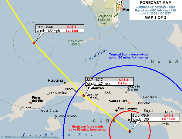
Dennis has made landfall near or just west of Cienfuegosa, Cuba (the same location as the radar below) and has weakened just a tad, but remains a strong Category 4 storm. New forecast track reasoning and analysis added from Clark Evans in the Met Blogs below.


Original Update
Dennis is a strong Category 4 storm with winds of 150mph as of 11am, and the track takes it to the eastern Gulf and eventually toward the Panhandle to New Orleans regions Sunday night and Monday morning. Radar imagery (below) and reconnaissance observations indicate a potential eyewall replacement cycle to come, though this might be interrupted by time over land this afternoon as it heads for the Gulf of Mexico. The track now takes it west of Key West.
Satellite imagery and upper air observations across the southern United States indicate that the ridge axis may be shrinking north-south with the approach of the storm, with a rather vigorous shortwave trough located along the Texas coast. It is not making much progress eastward at this time, though the southern extent over northern Mexico is building southward. Additional energy currently over the central Plains is headed south towards this shortwave and should help move it east -- how far east and how strong at that point will deternine when exactly Dennis makes its turn, as well as how sharp of a turn it will be.
The rest of the Gulf awaits as it crosses Cuba and everyone from Louisiana east to South Florida needs to pay close attention to the overall track of the storm through the day.
 
The following is a mirrored radar image from Cienfuegosa, Cuba, through 10:30am local time as Dennis approached, making landfall just west of the radar at 2pm ET. The radar continues to transmit images, but with a couple hours' delay.

Site Note News talkbacks are now in lockdown mode, which means that unregistered users cannot reply.
You can still post in the other forums besides talkbacks. This enables us to moderate a lot better. I hate doing this, but I can see obvious signs of "storm stress" on a few individuals. We'll make it open again as soon as it calms down.
Registration is open for anyone, you can register Using this link. Then you will be able to reply here.
Hopefully this will only last a short time.
Event Related Links
Emergency Management
FloridaDisaster.org - Florida Emergency Management
Monroe County/Florida Keys,
Panhandle Coastal Counties West to East
Escambia County, FL, Santa Rosa, County, Okaloosa County, FL,
Walton County, FL,
Bay County, FL, Gulf County, FL, Franklin County, FL...
StormCarib hurricane reports from observers in the Islands - Jamaican StormCarib Reports
Caribbean Island Weather Reports
Guantanamo Bay, Cuba Radar
Florida Keys Long Range Radar Loop
Tampa Bay, FL Long Range Radar
Miami, FL Long Range Radar
Melbourne, FL Long Range Radar
Tallahassee, FL Long Range Radar
Mobile, AL Long Range Radar
Dennis
High Speed Storm Relative Floater - RAMSDIS ONLINE
Animated Model Plot of Dennis
Model Plot Graphic from the South Florida Water Management District of Dennis
Dennis Spaghetti Model from boatus
Weather Underground Model Plots for Dennis
Quikskat Image of Dennis
Color Sat of Dennis
Floater Satellite (Visible) of Dennis with Storm Track Overlays
Cienfuegosa, Cuba Radar - (Animated)
RAMSDIS high speed visible Floater of Dennis
Forecast Discussions for (Show All Locations):
Tampa. Mobile Bay,
New Orleans, Key West, Tallahassee.
Melbourne
|
|
Liz
|
|
(Weather Watcher)
|
|
Fri Jul 08 2005 02:33 PM
|
|
|
|
|

|
|
|
Re: Dennis Deepens
|
|
Really appreciate that radar of Cuba. He is really BIG!
Liz
|
|
trinibaje
|
|
(Weather Guru)
|
|
Fri Jul 08 2005 02:34 PM
|
|
|
|
|
|
|
|
|
Re: Dennis Deepens
|
|
My prayers are with the Cuban people being affected.. He is huge and dangerous 
|
|
Katie
|
|
(Weather Guru)
|
|
Fri Jul 08 2005 02:39 PM
|
|
|
|
|

|
|
|
Re: Dennis Deepens
|
|
Wow, he looks pretty darn impressive. I feel sorry for everyone down there.
|
|
bn765
|
|
(Weather Hobbyist)
|
|
Fri Jul 08 2005 02:39 PM
|
|
|
|
|
|
|
|
|
Re: Dennis Deepens
|
|
Could be lookin at a Cat 5 very soon
|
|
pcola
|
|
(Storm Tracker)
|
|
Fri Jul 08 2005 02:43 PM
|
|
|
|
|

|
|
|
Re: Dennis Deepens
|
|
150 mph at the 11 am.
|
|
Liz
|
|
(Weather Watcher)
|
|
Fri Jul 08 2005 02:43 PM
|
|
|
|
|
|
|
|
|
Re: Dennis Deepens
|
|
I agree....My prayers go out to those there  Where do they evacuate to? Where do they evacuate to?
|
|
Droop31
|
|
(Weather Watcher)
|
|
Fri Jul 08 2005 02:45 PM
|
|
|
|
|
|
|
|
|
Re: Dennis Deepens
|
|
Yea I feel sorry for the folks in Cuba. Im a nervous wreck right now, Im praying this thing weakens some over Cuba. I dont want to deal with a cat4. Anyone see some reasons that would make it weaken in the gulf?
|
|
doug
|
|
(Weather Analyst)
|
|
Fri Jul 08 2005 02:45 PM
|
|
|
|
|
|
|
|
|
Re: Dennis Deepens
|
|
Radar confirms motion toward eventual exit between 81-82w, that is what I'm looking for...still think the generalized motion of the moisture off the coast from that point ahead of the system is NNW...all the way to the panhandle.
|
|
gavsie
|
|
(Verified CFHC User)
|
|
Fri Jul 08 2005 02:46 PM
|
|
|
|
|

|
|
|
Re: Dennis Deepens
|
|
Is there a new track out for Dennis?
|
|
Prospero
|
|
(Storm Tracker)
|
|
Fri Jul 08 2005 02:46 PM
|
|
|
|
|

|
|
|
Re: Dennis Deepens
|
|
Here in the Tampa Bay area you can "feel" something in the air. Whenever a storm approaches there is something different about how the air feels. I imagine wild animals and birds are getting a bit stirred up. Last night I watch a dolphin swimming just feet away from the shoreline off the Courtney Campbell Causeway. I bet the trees can feel it.
If I were in the mountains of Colorado where I lived for 20 years, I'd be preparing for several feet of snow. It is the same "feel" in the air.
Somethin's happening out there...
|
|
trinibaje
|
|
(Weather Guru)
|
|
Fri Jul 08 2005 02:47 PM
|
|
|
|
|
|
|
|
|
Re: Dennis Deepens
|
|
Quote:
I agree....My prayers go out to those there Where do they evacuate to?
I don't know about Cuba, but i know for many islands there are hurricane shelters... now how storm worthy are they? That's a whole different issue.
|
|
PFSThunder
|
|
(Weather Watcher)
|
|
Fri Jul 08 2005 02:47 PM
|
|
|
|
|

|
|
|
Re: Dennis Deepens
|
|
The eye is now visible on the Key West Long range radar loop.
http://www.srh.noaa.gov/ridge/byx_N0Z_lp.html
|
|
Clark
|
|
(Meteorologist)
|
|
Fri Jul 08 2005 02:51 PM
|
|
|
|
|
|
|
|
|
Re: Dennis Deepens
|
|
New track as of 11a is a little to the right of the previous track per the NHC discussion, but by the thinnest of margins. Best I can tell, it has landfall near the same point as Ivan, albeit at a different angle. We'll see what the 12z model runs bring with the system.
|
|
Ricreig
|
|
(User)
|
|
Fri Jul 08 2005 02:51 PM
|
|
|
|
|

|
|
|
Re: Dennis Deepens
|
|
Quote:
Dennis is a strong Category 4 storm with 150MPH winds, and a unbelievably low barometric pressure of 938 mb... for July.. and the track takes it to the eastern Gulf and eventually toward the Panhandle to New Orleans regions Sunday night and Monday morning.
This radar shows a track that will take the storm to about 24N 84W. The track should miss Key West far enough West of Key West to spare them the brunt of the storm but due to the size, probably will feel some hurricane force winds. On that track also, looking at the map superimposed on the radar display, it would seem to confirm that the rest of South Florida whould not be affected directly, Thankfully. Once it does get to about 85W, the peninsula cand start to breathe easier unless Dennis starts to move NNE which doesn't seem likely at the moment. Trends are friends but my thought is that there are VERY few friends you would trust your life to. So, stay alert. I agree with Mike on this one, Louisiana is NOT out of the running for this booby-prize but with the weakening ridge to the East, I wouldn't bet against a landfall in the panhandle of Florida either. Wherever it goes, someone is going to be hurt, especially if unprepared for a storm of this magnitude. Good luck to all in the path.
|
|
AgentB
|
|
(Weather Guru)
|
|
Fri Jul 08 2005 02:51 PM
|
|
|
|
|

|
|
|
Re: Dennis Deepens
|
|
Still looking NW, and has picked up just a bit to 15mph. Hurricane force winds extend outward to 50mi and t.s. force winds outward to 160mi. Definitely saying a prayer for the people of Cuba, and the other Carribbean islands. I'll be watching to see where Dennis crosses Cuba. Right now the forecast calls for him to come onshore just east of Playa Giron. I'm curious as to whether or not that comes to fruition. I've also been thinking a lot of the people I knew when I lived in Key West. Things aren't looking too great for them right now.
|
|
ftlaudbob
|
|
(Storm Chaser)
|
|
Fri Jul 08 2005 02:52 PM
|
|
|
|
|

|
|
|
Re: Dennis Deepens
|
|
Quote:
Is there a new track out for Dennis?
That is what I would like to know.
|
|
AgentB
|
|
(Weather Guru)
|
|
Fri Jul 08 2005 02:58 PM
|
|
|
|
|
|
|
|
|
Re: Dennis Deepens
|
|
Quote:
Quote:
Is there a new track out for Dennis?
That is what I would like to know.
I haven't seen one from the NHC. However, if you click on "coordinates" on the left of the screen, then click on "plot" by the storm name, you can loop the different models. Clicking "last" before you click "play" however gives you the most up-to-date frame of the models(I think).
|
|
|
|
Re: Dennis Deepens
|
|
11 AM is out.. Track edged slightly to East..
|
|
Ricreig
|
|
(User)
|
|
Fri Jul 08 2005 03:03 PM
|
|
|
|
|
|
|
|
|
Re: Dennis Deepens
|
|
Quote:
Quote:
Is there a new track out for Dennis?
That is what I would like to know.
Take a look at
http://www.nrlmry.navy.mil/tc_pages/ATL/04L.DENNIS/ssmi/gif/full/Latest.html
|
|
VandyBrad
|
|
(Weather Hobbyist)
|
|
Fri Jul 08 2005 03:04 PM
|
|
|
|
|

|
|
|
Re: Dennis Deepens
|
|
For those that were interested yesterday...
NASA has decided to leave the shuttle on the launch pad and is holding to its scheduled Wednesday launch.
http://www.orlandosentinel.com/news/custom/space/orl-bk-shuttle070805,0,5120048.story?coll=orl-home-headlines
|
|
pcola
|
|
(Storm Tracker)
|
|
Fri Jul 08 2005 03:07 PM
|
|
|
|
|
|
|
|
|
Re: Dennis Deepens
|
|
I find it amazing that the NHC has not moved its track to the pandle more than 60 miles for 5 days. They seem to be doing a great job..though it does not look good for me.
|
|
Ed in Va
|
|
(Weather Master)
|
|
Fri Jul 08 2005 03:08 PM
|
|
|
|
|
|
|
|
|
Re: Dennis Deepens
|
|
11 discussion here:http://www.crownweather.com/tropical.html
|
|
NewWatcher
|
|
(Storm Tracker)
|
|
Fri Jul 08 2005 03:10 PM
|
|
|
|
|

|
|
|
Re: Dennis Deepens
|
|
11 AM TRACK
http://www.nhc.noaa.gov/refresh/graphics_at4+shtml/144557.shtml?5day?large
|
|
Lysis
|
|
(User)
|
|
Fri Jul 08 2005 03:11 PM
|
|
|
|
|

|
|
|
Re: Dennis Deepens
|
|
If Dennis were to briefly achieve minimal Category 5 status just before landfall, would there be any way that we would know?
|
|
Ricreig
|
|
(User)
|
|
Fri Jul 08 2005 03:15 PM
|
|
|
|
|
|
|
|
|
Re: Dennis Deepens
|
|
Quote:
I find it amazing that the NHC has not moved its track to the pandle more than 60 miles for 5 days. They seem to be doing a great job..though it does not look good for me.
I agree, they have done a good job so far. Thier forecast has wiggled very little almost from day 1. The models have been all over the place,but even they have averaged out close to a similar track. If the forcast pans out as accurate, a lot of people have only a little more than a day and a half to CYOA and get their preparations completed and in some cases, 'outta Dodge' as well.
|
|
Jamiewx
|
|
(Storm Tracker)
|
|
Fri Jul 08 2005 03:16 PM
|
|
|
|
|

|
|
|
Re: Dennis Deepens
|
|
"THE LATEST RADAR DATA ALSO SUGGESTS THAT DENNIS MAY BE STARTING AN EYEWALL REPLACEMENT CYCLE...WHICH WOULD SUGGEST THAT DENNIS HAS LIKELY PEAKED IN INTENSITY. "
From the 11am Discussion
|
|
|
|
Re: Dennis Deepens
|
|
Actually if the forecast pans out, these people in the panhandle have had ample time to get their preparations in order, not just a day and a half. Unless they have been living with their head in the sand. NHC has had this track for a few days now..
|
|
ftlaudbob
|
|
(Storm Chaser)
|
|
Fri Jul 08 2005 03:18 PM
|
|
|
|
|
|
|
|
|
Re: Dennis Deepens
|
|
I just heard that 60% of the locals in Key West are staying.I just don't understand that.
|
|
Rich B
|
|
(British Meteorologist)
|
|
Fri Jul 08 2005 03:18 PM
|
|
|
|
|
|
|
|
|
Re: Dennis Deepens
|
|
Dennis is a monster! And still relatively compact with hurricane winds only out to 50 miles. It wouldnt be a surprise if Dennis breifly attains Cat5 status, but the indications of an ERC could put pay to that. Looks like nowhere in Cuba will escape untouched - either from the winds, or from the rain, or from the huge surge! Should be interesting to see what happens to the core when it crosses overland. I still think we'll see an expansion of the windfield, and a larger eyewall form.
|
|
|
|
Key West
|
|
Some interviews showed them saying after last years evacs they felt it was crying wolf...foolish if you ask me...that place is only like 7 miles wide at it's widest...depending on how close Dennis gets it could be devestating to that area.
Love it down there.
|
|
Lysis
|
|
(User)
|
|
Fri Jul 08 2005 03:23 PM
|
|
|
|
|
|
|
|
|
Re: Key West
|
|
Why would the West Atlantic be under a Tropical Storm Warning and the extreme south eastern counties of Florida under a hurricane watch, while the west coast is under only a tropical storm watch, with no advisories for the adjacent waters whatsoever?
|
|
Lisa NC
|
|
(Weather Guru)
|
|
Fri Jul 08 2005 03:23 PM
|
|
|
|
|
|
|
|
|
Re: Dennis Deepens
|
|
Does anyone know what the landscape is like where Dennis will cross Cuba? Is it normal for a hurricane to strengthen whille 1/3 of its mass is over land?
|
|
G. J.
|
|
(Weather Watcher)
|
|
Fri Jul 08 2005 03:24 PM
|
|
|
|
|

|
|
|
Re: Key West
|
|
Anyone here anything from friends, relatives, or through military channels how Gitmo has fared?
|
|
Ricreig
|
|
(User)
|
|
Fri Jul 08 2005 03:25 PM
|
|
|
|
|
|
|
|
|
Re: Dennis Deepens
|
|
Quote:
Actually if the forecast pans out, these people in the panhandle have had ample time to get their preparations in order, not just a day and a half. Unless they have been living with their head in the sand. NHC has had this track for a few days now..
It is also true that there are a substantial number of people that are blissfully ignorant until it is too late, OR, that choose to do the Osterich thing and bury their heads in the sand in the hopes that it will go away if they just ignore it long enough. Sad, but true. Denial kills.
|
|
pcola
|
|
(Storm Tracker)
|
|
Fri Jul 08 2005 03:27 PM
|
|
|
|
|
|
|
|
|
Re: Dennis Deepens
|
|
Trust me...the people in the panhandle are preparing...it has been hard to get gas for 3 days....more are evacuating.....Ivan is a recent memory...
|
|
Ricreig
|
|
(User)
|
|
Fri Jul 08 2005 03:28 PM
|
|
|
|
|
|
|
|
|
Re: Key West
|
|
Quote:
Why would the West Atlantic be under a Tropical Storm Warning and the extreme south eastern counties of Florida under a hurricane watch, while the west coast is under only a tropical storm watch, with no advisories for the adjacent waters whatsoever?
Relative position/distance from where the storm *is* at the moment. These warnings will shift and migrate as the storm moves.
|
|
lilyv
|
|
(Weather Watcher)
|
|
Fri Jul 08 2005 03:30 PM
|
|
|
|
|
|
|
|
|
Re: Dennis Deepens
|
|
Quote:
Actually if the forecast pans out, these people in the panhandle have had ample time to get their preparations in order, not just a day and a half. Unless they have been living with their head in the sand. NHC has had this track for a few days now..
Yes, but I was in P'cola a month ago, and I was truly shocked at the extent of destruction that is still evident. An entire apartment complex near Sacred Heart is abandoned, for example. All over town there are blue tarps on houses, windows still in need of repair, awnings that are half off, businesses that never re-opened, and so on. They can prepare, but more damage piled ontop of the old damage makes this current situation much more dangerous. Add into the equation that the folks are really tired from working so hard to recover from Ivan. The good folks of the panhandle are in my thoughts and prayers.
|
|
Katie
|
|
(Weather Guru)
|
|
Fri Jul 08 2005 03:31 PM
|
|
|
|
|
|
|
|
|
Re: Key West
|
|
FOX news just said that the Keys will be getting a direct hit with winds at 150 mph...I sure hope they evacuated. Any idea on high tide and when he is suppose to cross over. I am just curious what kind of damage he can cause on our islands down there.
Yeah, people in the Panhandle aren't joking with him. My former boss in Pensacola is packing up the family and heading elsewhere. They lost their house in Ivan and don't want to be around if Dennis makes his way up there.
|
|
doug
|
|
(Weather Analyst)
|
|
Fri Jul 08 2005 03:31 PM
|
|
|
|
|
|
|
|
|
Re: Dennis Deepens
|
|
The most interesting thing in the discussion was the comment about the deepening trough to the west and a couple of the models getting a handle on that: creating a slight deviation to the right in the solution...about 40 miles worth it looks like.
watching the water vapor suggests the jet is clearly now setting up cutting across the northern expense of the peninsula at the Big Bend area...this is the kind of thing which falls into my OOPS factor and if this is in fact deepening...well how many ways can we spell Charley, only this time further up the coast...??/ I am CONCERNED on this point and wish one of our Mets could address it....
Also the satellite presentation is showing an elongation to the NNW which is often an indicator of future direction...
The radar presentation shows steady progress directly toward the site.
|
|
damejune2
|
|
(Storm Tracker)
|
|
Fri Jul 08 2005 03:32 PM
|
|
|
|
|

|
|
|
Re: Dennis Deepens
|
|
I think there are some mountains in the region, but certainly not enough to really hinder the storm. Maybe if the storm was traveling at a really slow pace, like under 10mph, it's possible that you may see some drastic drop in intensity, but i doubt that will happen. Years ago i saw a cat 4 go through Dominican Rep/Haiti: mostly mountains and rugged terrain. When the storm emerged on the other side, it took less than one advisory for it to gain it's strength again. I think it was Georges and maybe it wasn't cat 4 at that time, but i know it hit those mountains and it did lose some kick, but it regained it all when it hit the water again.
|
|
drcrazibob
|
|
(Weather Watcher)
|
|
Fri Jul 08 2005 03:33 PM
|
|
|
|
|

|
|
|
Re: Key West
|
|
I've noticed that as well on the local weather. I'm in Daytona Beach and believe it or not, I've seen a few people starting to grab supplies at places like WalMart.
By the way, I've been watching this site for 2 years now. Although this is my first post, I have found the information on here to be outstanding! Keep the info coming!
|
|
|
|
Re: Key West
|
|
They'll get the effects from the weather 1st? Sure as time goes the watches/warnings will change as needed.
|
|
|
|
Re: Key West
|
|
Quote:
FOX news just said that the Keys will be getting a direct hit with winds at 150 mph...I sure hope they evacuated. Any idea on high tide and when he is suppose to cross over. I am just curious what kind of damage he can cause on our islands down there.
Yeah, people in the Panhandle aren't joking with him. My former boss in Pensacola is packing up the family and heading elsewhere. They lost their house in Ivan and don't want to be around if Dennis makes his way up there.
I wished my Family would do the same. They are in Grand Bay, AL and are "waiting to see where it goes." I know they will not have time to avacuate if necessary.
Anyone in the Mobile area - have you heard where the shelters are? I know during Ivan, there where hardly any shelters open and most of the Mobilians had to go to Baldwin CO for shelters.
|
|
tpratch
|
|
(Moderator)
|
|
Fri Jul 08 2005 03:38 PM
|
|
|
|
|

|
|
|
Re: Key West
|
|
Quote:
FOX news just said that the Keys will be getting a direct hit with winds at 150 mph...
Just remember to temper that statement with knowledge of the source.
That network does hurricane coverage in a highly melodramatic way. My friend in Connecticut remarked after watching Fox coverage of Frances, that he was surprised that I
A) stayed in my block-contrstucted house
B) wasn't blown away by the high winds
C) wasn't having to tread water due to the storm surge
D) was alive at all
Bear in mind, of course, that I was in Brevard County and about 1 mile inland from the river in an area with solid drainage.
Don't get me wrong, I get a kick out of watching that station, but I'm not so sure about the Keys getting a direct, 150mph hit... 
|
|
|
|
Cuba kick
|
|
I think it will kick slightly left to miss the mountains.....as it gets nearer and near to Cuba.....just look at the water vapor loop...the storm is gonna get knocked a little off course....and we won't know the real cone of disaster fully till it leaves Cuba...
as it gets into Cuba...what direction will the kick take..if any at all?....
to many variables...who really knows?....
|
|
pcola
|
|
(Storm Tracker)
|
|
Fri Jul 08 2005 03:39 PM
|
|
|
|
|
|
|
|
|
Re: Key West
|
|
Most shelters are not strong enough for a catagory 3. In Pensacola, the civic center lost iys roof during Ivan. They are better than a mobile home but if you are out of storm surge a good built house is safer.
|
|
|
|
Re: Key West
|
|
Quote:
Most shelters are not strong enough for a catagory 3. In Pensacola, the civic center lost iys roof during Ivan. They are better than a mobile home but if you are out of storm surge a good built house is safer.
Thats the problem..they are not...
|
|
tpratch
|
|
(Moderator)
|
|
Fri Jul 08 2005 03:44 PM
|
|
|
|
|
|
|
|
|
Re: Key West
|
|
Excellent point. The nearest shelter to my old house was a 5 year-old elementary school about a quarter mile away.
They lost part of their roof during Jeanne. Of course, the school was also right off of the main road with very few trees/buildings blocking the wind, so it took everything head-on, whereas my neighborhood had lots of winding roads to help reduce the amount of "wind tunnel" effect.
If you're going to stay, stay in the safest location possible.
|
|
cjzydeco
|
|
(Weather Guru)
|
|
Fri Jul 08 2005 03:44 PM
|
|
|
|
|

|
|
 Map of Cuba
|
|
Can't yet find a good topo map of cuba, but here is a shaded relief map of Cuba.
Shaded Relief Map of Cuba
|
|
SkeetoBite
|
|
(Master of Maps)
|
|
Fri Jul 08 2005 03:45 PM
|
|
|
|
|

|
|
|
Re: Key West
|
|
Quote:
FOX news just said that the Keys will be getting a direct hit with winds at 150 mph....
See updated maps at the top of this thread.
|
|
mbfly
|
|
(Weather Guru)
|
|
Fri Jul 08 2005 03:45 PM
|
|
|
|
|

|
|
|
Re: Key West
|
|
Last I heard, a lot of the Mobile County schools were going to open as shelters whereas a lot of Baldwin County will not. I'm sure Baker H.S. in west Mobile will, as it has no windows and is rated as a shelter. I'll probably be riding it out in West Mobile as well, because hubby is too stubborn to leave. *gulp*
|
|
Lysis
|
|
(User)
|
|
Fri Jul 08 2005 03:47 PM
|
|
|
|
|
|
|
|
|
Re: Key West
|
|
Hey Skeet, can you provide a map that includes the diameter of the storm through its whole track north?
EDIT: Yes, Katie... that was 150 nmi *out from the center*, not 150 mph winds.
|
|
|
|
Re: Dennis Deepens
|
|
Quote:
The most interesting thing in the discussion was the comment about the deepening trough to the west and a couple of the models getting a handle on that: creating a slight deviation to the right in the solution...about 40 miles worth it looks like.
watching the water vapor suggests the jet is clearly now setting up cutting across the northern expense of the peninsula at the Big Bend area...this is the kind of thing which falls into my OOPS factor and if this is in fact deepening...well how many ways can we spell Charley, only this time further up the coast...??/ I am CONCERNED on this point and wish one of our Mets could address it....
Also the satellite presentation is showing an elongation to the NNW which is often an indicator of future direction...
The radar presentation shows steady progress directly toward the site.
i was also notice'n a more nnw trend could be a woble .. who knows .. but i was curious about the jet .. stering the storm .. more towards the west coast of central FL .. any of our Mets have any imput on what doug stated ?
|
|
lawgator
|
|
(Weather Hobbyist)
|
|
Fri Jul 08 2005 03:48 PM
|
|
|
|
|
|
|
|
|
Re: Dennis Deepens
|
|
I love the box you added to the forecast track map with the storm making landfall right on top of Jim Cantore. A little gallows humor?
|
|
|
|
Re: Dennis Deepens
|
|
Quote:
I love the box you added to the forecast track map with the storm making landfall right on top of Jim Cantore. A little gallows humor?
I saw that too.....lol
|
|
AgentB
|
|
(Weather Guru)
|
|
Fri Jul 08 2005 03:53 PM
|
|
|
|
|
|
|
|
|
Re: Dennis Deepens
|
|
Quote:
I just heard that 60% of the locals in Key West are staying.I just don't understand that.
It's a very different mindset there. Some have boats that they don't want to leave, others don't want to be stuck on one of the bridges and not make it totally out of the Keys. They figure if they have a chance of getting stuck in the Keys it might as well be at their house, boat, houseboat, even if it is a bit closer to the eye.
|
|
Clark
|
|
(Meteorologist)
|
|
Fri Jul 08 2005 03:54 PM
|
|
|
|
|
|
|
|
|
Re: Dennis Deepens
|
|
Doug -- I think you hit the nail on the head with most of your analysis, though I wouldn't go for the Charley scenario at all right now. Dennis is probably a strong enough storm -- and will be one -- to be able to resist much of a sudden turn to the northeast. It is already strong enough to appear to be eating into the southern extent of the ridge, likely a result of weakening steering currents in the region as the pattern tries to change and the hurricane enters the area. What it all means...well, we'll just have to wait and see.
For what it's worth, the 12z GFS takes the storm almost north from here, bringing it very near Ft. Myers, then turning it back to the NW. Landfall ultimately occurs in ~54hr near Destin after riding up the coast from Apalachicola. It does slow it down west of Tampa, which would be interesting to see if it occurs, just for the final impact it'd have on the track.
|
|
mbfly
|
|
(Weather Guru)
|
|
Fri Jul 08 2005 03:55 PM
|
|
|
|
|
|
|
|
|
Re: Dennis Deepens
|
|
It would be funnier if I wasn't so close to it !!! 
|
|
yecatsjg
|
|
(Weather Watcher)
|
|
Fri Jul 08 2005 03:55 PM
|
|
|
|
|
|
|
|
|
Re: shelters
|
|
I work at a school in Sarasota and we already have our hurricane supplies from the county. We are a "special needs" shelter so we always open first. Staff was told to lock everything up just in case. Right now we aren't open, but will know around 4:00/5:00 if we will open. I was told it would be due to tropical storm winds and voluntary evacuations.
Stacey
|
|
HumanCookie
|
|
(Verified CFHC User)
|
|
Fri Jul 08 2005 03:57 PM
|
|
|
|
|

|
|
|
Re: Key West
|
|
http://www.chron.com/cs/CDA/ssistory.mpl/front/3257501
Quote:

High waves crash the shoreline of the Guantanamo Bay Naval Station, Cuba, as Hurricane Dennis slams into the island. The Category 4 storm is expected to hit the main island today and is on a path to threaten Florida this weekend, where evacuations are under way.
Quote:
GUANTANAMO BAY NAVAL STATION, Cuba — Packing devastating 135 mph winds, Hurricane Dennis tore down a guard tower at the U.S. detention camp for terror suspects as it stalked Cuba's south coast and prepared today to strike into the heart of the largest Caribbean island.
Thousands of residents and tourists fled the Florida Keys, fearing Dennis would skirt the island chain or hit it on its way to the Gulf of Mexico, on a path that raised fears of further disruption to U.S. oil operations.
A Category 4 storm with 135-mph winds, Dennis killed five people, collapsed a bridge and blocked roads with downed power lines and trees in Haiti and Jamaica on Thursday.
The eye was taking aim at central Cuba this morning from 60 miles at sea, a few miles short of the storm's most dangerous winds, the U.S. National Hurricane Center said.
"It's right off the coast, they'll be getting hurricane-force winds before long if they haven't already," meteorologist Trisha Wallace told The Associated Press by telephone from the center in Miami.
Hurricane-force winds extended 50 miles with tropical storm force winds stretching another 140 miles. Dennis was moving northwest near 12 mph.
The first hurricane of the season sideswiped Haiti and Jamaica on Thursday, then overnight crossed a sparsely populated Cuban cape at Cabo Cruz that juts out far west of the island, Wallace said.
Dennis was expected to strike again tonight and cross central and western Cuba, including Havana.
Forecasters predict the storm will intensify and hit the United States anywhere from Florida to Louisiana by Sunday or Monday, the fourth storm in as many weeks to disrupt oil production.
The Florida Keys were on hurricane warning and the rest of the peninsula on tropical storm watch.
Thunderstorms swept over the Dominican Republic, southern Haiti and northeast Jamaica on Thursday.
Today, the Cayman Islands downgraded its hurricane warning to a tropical storm watch, spared from a direct hit by the storm's overnight turn to the west.
Also spared overnight was the U.S. detention camp on Cuba's extreme southeast end, holding some 520 terror suspects.
Heaving surf tore away a lifeguard tower at Windmill Beach and storm force winds reaching 40 mph destroyed a bus shelter. A few power lines and tree branches were knocked down and there was minor flooding.
"Actually, everybody fared real well," said Navy Cmdr. Anne Reese.
On Thursday, troops watched from a cliff as the churning Atlantic Ocean threw up massive waves of salt spray that towered over the razor wire fence surrounding the camp at Guantanamo Bay.
The troops fixed metal shutters over the steel mesh windows of some prison cells overlooking the sea at Camp Delta, which is just 150 yards from the ocean.
Hurricane Center forecasters warned Cuba's southeast Sierra Maestra Mountains could get up to 15 inches of rain, with about 10 inches falling on Jamaica's coffee-producing Blue Mountains.
In the southwest Haitian town of Grand Goave, an Associated Press Television News reporter saw at least four people die when a wood and metal bridge collapsed.
Witnesses said the river suddenly came rushing over the bridge. That cut off Haiti's southwest peninsula from the rest of the country.
Elsewhere on the dangerously deforested island, wind gusts uprooted a palm tree and flung it into a mud hut, killing a fifth person in the southern town of Les Cayes, the Red Cross said.
Floodwaters rose to waist level in an abandoned church in Les Cayes and nearly reached a table where 63-year-old Eloge Larame lay down, ill. His family of five stood on chairs, their feet still in water.
Wind gusts ripped tin roofs from homes and whipped sheets of rain that flooded roads.
In Jamaica, floods and debris blocked the road leading from the capital, Kingston, to the storm-battered east.
A man there narrowly escaped from a car swept away by fast-flowing floodwater on Wednesday night, a day before the hurricane passed.
Cuba evacuated more than 100,000 people from the southeast on Thursday, civil defense officials said on state television. Hundreds of tourists were taken to hotels in Havana and northern Varadero beach resort.
Thousands of students at government boarding schools were being sent home, and livestock was moved to higher ground.
The largest and most populous Caribbean island with 11.2 million people, Cuba suffers few hurricane casualties because the government cautiously evacuates people en masse, sometimes forcefully.
Dennis came right behind Tropical Storm Cindy, which made landfall late Tuesday in Louisiana and hindered oil production and refining. On Thursday, remnants of Cindy dumped heavy rain on parts of the Carolinas, prompting flash flood and tornado watches.
The hurricane center's lead forecaster, Martin Nelson, said it was the first time the Atlantic hurricane season had four named storms this early since record-keeping began in 1851. The season runs from June 1 to Nov. 30.
Last year, three catastrophic hurricanes — Frances, Ivan and Jeanne — tore through the Caribbean with a collective ferocity not seen in years, causing hundreds of deaths and billions of dollars in damage.
|
|
|
|
Re: Dennis Deepens
|
|
Thanks Clark for your insite =D
|
|
adogg76
|
|
(Weather Hobbyist)
|
|
Fri Jul 08 2005 04:01 PM
|
|
|
|
|
|
|
|
|
Re: Map of Cuba
|
|
Seems like Dennis "wants" to miss those mountains in Cuba!!
|
|
msmith43
|
|
(Verified CFHC User)
|
|
Fri Jul 08 2005 04:02 PM
|
|
|
|
|
|
|
|
|
Re: Dennis Deepens
|
|
Agreed. I always anticipate comments from Clark.
|
|
rmbjoe1954
|
|
(Weather Master)
|
|
Fri Jul 08 2005 04:03 PM
|
|
|
|
|

|
|
|
Jet Stream Impact
|
|
I understand that there is that chance of the jet stream forcing a curve toward the north, but we are dealing with a powerful (who knows what category in the open gulf) hurricane that wouldn't follow conventional wisdom and allow the jet stream to turn it towards the west-central coast. Also, that trough may yet be a factor when the system gets into the SE GOM. The NHC has taken these events into account in determining the impact they will have in 48 hours.
I would wait to see what the models' solutions will look like when Dennis enters the GOM.
|
|
|
|
Re: Map of Cuba
|
|
it will miss the mountains....because they are resistance...it will feel its way around the mountains...and cross the mainland of Cuba where it is more flat....
worst case scenario....
enter the GOM as a major hurricane...and vascillate between category 4-5.....
and totally aggravate everyone from New Orleans to Tampa....
still think a Mississippi/AL state line hit...but I wouldn't discount Joe Bastardi's thoughts....
anyone have a connection to his thoughts this morning?
|
|
VandyBrad
|
|
(Weather Hobbyist)
|
|
Fri Jul 08 2005 04:07 PM
|
|
|
|
|
|
|
|
|
Re: Map of Cuba
|
|
This morning JB was saying much of what he has been saying all week. He is bashing the models for initializing Dennis too far north or east of its current position and this initilization resulting in a more eastward biased track. He still firmly believes in a doomsday scenario for New Orleans.
|
|
|
|
Re: Map of Cuba
|
|
Channel 9 out of Orlando just announced that the Space Shuttle will stay on the pad. The NASA officials do not believe the weather will be severe enough to move the shuttle. I am not doubting anything except the timeline that it takes to move it in the first place. But, if this is a signal that the bulk of the storm will miss Central Florida and we will just get Tropical force winds, rain and isolated tornados, that is good sleeping weather. However, I have family in the direction they are loosely describing just west of Pensacola. I am not a happy Camper and may attempt to drive up there since they are elderly and my dad is on oxygen24/7. I really do not know what decision to make yet.
|
|
MissBecky
|
|
(Weather Guru)
|
|
Fri Jul 08 2005 04:15 PM
|
|
|
|
|

|
|
|
Re: Dennis Deepens
|
|
Clark, this is not what I wanted to hear. Most people in my office are feeling overconfident about Dennis staying far away, and thinking we will only get "some rain" this weekend. I wish the NHC would upgrade our watch to a Hurricane Watch. It might make people pay more attention to what's going on out there.
|
|
Unregistered User
|
|
(Unregistered)
|
|
Fri Jul 08 2005 04:15 PM
|
|
|
|
|
|
|
|
|
Re: Dennis Deepens
|
|
#57 Published Friday July 08, 2005 at 10:45 am EDT
At the 11:00 am EDT advisory Hurricane Dennis has a sustained wind of 150 mph, a strong CAT 4 cyclone and just short of a CAT 5. It's at position 21.4 N 79.9 W with a minimum barometric pressure of 27.70". He continues on a NW heading or approximately 310 degrees at a speed of 16 mph. During the past 12 hours he has been wobbling on a heading between about 300-320 deg. as he has undergone eyewall reformation cycles and also interacted somewhat with land.
What is interesting to note is that even with the land interaction Dennis has continued to strengthen to just short of CAT 5, much like Ivan did last summer. As he comes ashore in west central Cuba today his heading should shift more north of west due to speed divergence and appear to be headed towards the southern Florida peninsula but then shift back more west of north as he enters the Florida Straits. Dennis is a small cyclone like Charley so is more easily pushed around so to speak. It was speed divergence that caused CAT 4 Charley to abruptly turn right and go ashore in the Charlotte Harbor area of SW Florida. I don't think that Dennis will get close enough to the land mass of Florida to pull another Charley.
Where is he headed? The models have shifted left and right during the last 12 hours and the NHC TPC forecast track has done the same. At the latest advisory the track has shifted a little to the right again with official landfall forecasted at Pensacola at approximately 2:00 pm EDT on Sunday.
It does now appear that the southern Florida Keys will experience hurricane conditions on Saturday. The whole of the west "coast" of Florida be in the most dangerous NE quadrant of the cyclone and will experience at least gale force wind conditions, storm surge of 3-5 feet, heavy rainfall and waterspouts. Inland areas of the western peninsula will experience wind gusts to gale force, very heavy rainfall and tornadoes in feeder bands. A track a little further west and the impact is less, a track a little further east and the impact is more.
Actual intensity of Dennis as it passes over or just west of Key West is a tough call. It will enter Cuba as a CAT 4 and exit a CAT 3. It all depends on how long the cyclone stays over land.
Bottom line? The Bermuda high pressure ridge over and east of Florida shows no further signs of weakening at this time. So no change in my forecast, it's still a landfall window between Pensacola and Fort Walton Beach on Sunday afternoon. Once in the Gulf Of Mexico Dennis will reach CAT 4 status again and maybe even flirt with CAT 5 status but should weaken to a CAT 3 by landfall due to less favorable conditions.
Take Care,
Thomas F. Giella, KN4LF
Retired Meteorologist & Space Plasma Physicist
Plant City, FL, USA
kn4lf@arrl.net
NWS Tampa Bay, FL SKYWARN Observer #HIL-249
Plant City, FL NWS CWOP Weather Station #AR692 Live Data: http://www.kn4lf.com/index1.html
Plant City, FL NWS CWOP Weather Station #AR692 3 Minute Data: http://www.kn4lf.com/index.html
Plant City, FL Daily Climatological Weather Data Archive Blog: http://www.kn4lf.com/kn4lf22.htm
Florida Daily Weather Discussion Blog: http://www.kn4lf.com/flwx1.htm
Florida Raw Weather Forecasting Product Links: http://www.kn4lf.com/kn4lf13.htm
Global Warming Refuted: http://www.kn4lf.com/kn4lf42.htm
|
|
WeatherNLU
|
|
(Meteorologist)
|
|
Fri Jul 08 2005 04:16 PM
|
|
|
|
|

|
|
|
Re: Dennis Deepens
|
|
Clark......I don't know about you but I am having a hard time buying the GFS since it can't even seem to nail the 6 and 12 hour forecasts. It seems to me to be too far north into Cuba right off of the bat. Maybe that's just me.
|
|
Wingman51
|
|
(Weather Guru)
|
|
Fri Jul 08 2005 04:19 PM
|
|
|
|
|

|
|
 Re: Key West
|
|
OK - - My Entire Office freaked out over the picture that "Was" posted with this story - - Wave or Clouds???? :?:
|
|
Ricreig
|
|
(User)
|
|
Fri Jul 08 2005 04:19 PM
|
|
|
|
|
|
|
|
|
Re: Map of Cuba
|
|
Quote:
really do not know what decision to make yet.
Here is I think, a win-win piece of advice. Drive now while you can. Take care of your parents. If the storm misses, you've visited family that may not be here forever, and if it does hit you will be able to evacuate them in time. Waiting may prevent both of those options. Ask yourself; "Can they do it withou my help?" Unless the answer is a resounding YES, Put a 5 gallon jerry can of gas in the car, refuel every 1/3 tank (in case stations in the destination are out of gas or lines robbing valuable time, and drive there like a life might depend on it.
|
|
|
|
Re: Key West
|
|
Thank you for the update on Gitmo. I'm glad to hear our soldiers are safe. I have to say, though, when I saw that picture, it really hit home how strong this storm is. Unbelievable...God Bless anyone in it's path.
|
|
|
|
Re: Dennis Deepens
|
|
Cuba has three major mountain ranges. In the west the Sierra de los Órganos range rises to the height of 800 m (2,500 ft) above sea level. In the south central region, the Sierra de Trinidad, or the Escambray mountains, tower 1,150 m (3,800 ft) above sea level and overlook the colonial city of Trinidad. In the east, Cuba’s tallest mountains are in the Sierra Maestra, topped by Real de Turquino peak at 2,005 m (6,578 ft) above sea level. The Sierra Maestra soar near the Caribbean’s Windward Passage, a strip of water that separates Cuba and Haiti. Cuba has several other prominent mountains and hills. Lying north of the Sierra Maestra are the Baracoa Highlands, which climb to 1,230 m (4,050 ft) above sea level. In the far western end of the island are large, haystack-shaped eruptions called mogotes in Spanish. These unique hills form the Sierra de los Órganos, which rise steeply from flat, lush valleys to heights of more than 300 m (1,000 ft).
On the southern shore are coral islands, reefs, and swamps. The largest harbors are Havana, Matanzas, Cienfuegos, Nuevitas, Guantánamo, and Santiago de Cuba. My wife is from Camaguey and has family there.
|
|
VandyBrad
|
|
(Weather Hobbyist)
|
|
Fri Jul 08 2005 04:22 PM
|
|
|
|
|
|
|
|
|
Re: Key West
|
|
Quote:
God Bless anyone in it's path.
Except maybe Castro...
|
|
WeatherNLU
|
|
(Meteorologist)
|
|
Fri Jul 08 2005 04:26 PM
|
|
|
|
|
|
|
|
|
Re: Map of Cuba
|
|
By the way per the 11AM press conferences:
Orleans Parish and most outlying parishes: Not requesting residents to do anything at this time except to make a plan and have it ready to execute if necessary.
Jefferson Parish: Asking residents who have the means to get out now to avoid to main rush. Asked state police to implement contraflow and they declined at this point. They have about five hours left to decide before the new 50 hour rule kicks in.
Should be an interesting afternoon.......they usually do these things together but they had seperate press conferences and seem to be on different pages regarding Dennis.
|
|
|
|
making landfall soon
|
|
looks to be with in the next 1 or 2 hours .. lookin @ the latest IR http://www.ssd.noaa.gov/PS/TROP/DATA/RT/float-ir2-loop.html
|
|
|
|
Aerial Photography Cuba & World
|
|
I am not sure if all of you are aware of this new program by Google. Download and take a look at Cuba aerial photography. It's free and VERY COOL.
http://earth.google.com/
Enjoy!
|
|
Lysis
|
|
(User)
|
|
Fri Jul 08 2005 04:29 PM
|
|
|
|
|
|
|
|
|
Re: Map of Cuba
|
|
Except maybe Castro
Ha! You know our relief budget for Cuba after Charley was laughable (I think it was something absurd like $30,000, and the Cuban government refused to accept it). I hope it isn't the same deal with Dennis.
|
|
VAgirl
|
|
(Registered User)
|
|
Fri Jul 08 2005 04:29 PM
|
|
|
|
|
|
|
|
 Re: Dennis Deepens
|
|
Just wondering if SNONUT is still around. Been reading his posts for several years now and miss his input/insight.
|
|
MissBecky
|
|
(Weather Guru)
|
|
Fri Jul 08 2005 04:29 PM
|
|
|
|
|
|
|
|
|
Re: Key West
|
|
Voluntary evacuations in Collier County will be beginning at 2:00 p.m., for anyone who lives in a manufactured home, or who lives near the coast.
|
|
|
|
Re: Key West
|
|
Also distances from coastlines would be great, if it can be added, thanks
|
|
HumanCookie
|
|
(Verified CFHC User)
|
|
Fri Jul 08 2005 04:31 PM
|
|
|
|
|
|
|
|
|
Re: Key West
|
|
It is High waves not cloud.
|
|
VandyBrad
|
|
(Weather Hobbyist)
|
|
Fri Jul 08 2005 04:32 PM
|
|
|
|
|
|
|
|
|
Re: making landfall soon
|
|
Looking at that IR loop... it appears that extrapolating the path of the eye takes it on a more N-NW course than the forcasted track.
|
|
|
|
Re: making landfall soon
|
|
not a good sign.. looks to me like ole'e Dennis is starting to make a more northerly turn instead of that WNW everyone wants to believe is going to happen. Somebody tell me this is NOT happening.
|
|
|
|
crossing cuba
|
|
after going wnw overnight the center is moving nw again.. looks like it will make landfall very close to cienfuegos. extrapolated path would take it back offshore near matanzas early in the evening. there is a saddle between uplands to the west near havana and the eastern two thirds of the island... dennis might thread the needle if it moves straight. then again, it will be landfalling near an eyewall replacement cycle.. last recon fix got 150kt flt lev winds and a 937 cpres. the storm will probably move offshore with its center in disarray... probably a 2/3. how quickly it spins back up is hard to say. environment and ssts in the se gulf will be supportive, so it will probably be 3/4 on saturday. the ssts in the northeast/north central gulf are 82-84, so it will probably be a 3 by that standard... then again it will be impacting the coast at more or less a right angle, which has been known to force minor strengthening. i'm really low confidence on this, but going to keep my target on walton/bay co florida as a cat 3 (105-110kt, 955mb or so), sunday afternoon. looked at joe b's thoughts and think they make sense too... aside from personal preferences the area around mobile/pensacola has been at the center of the model spread for a couple of days.
joe b is calling for the wave at 30w to develop over the coming days. i've been with him on that.. should really do much until it gets near 45w though. more northerly track, he says. yeah, models are doing that... did with pre-dennis, but i don't think this one will wait til the caribbean to develop. might bug luis next week... east coast worry if anything beyond that.
keep an eye on the western caribbean in the wake of dennis. a couple of models are following pressure falls there early next week (canadian, ukmet).. around the time that wave near 60w should be arriving on the scene.
by the way, also checked for 'analogs' last night. for cat 4 hurricanes in july, the ones in 1916 (gulf) and 1926 (bahamas, e fl) were the only two i spotted. audrey in '57 was very late june, so worth note in that sense. there were a few other seasons with early season activity like this one... 1959 for instance had it's 4th named storm form on july 5th (and get its name on july 7th).. 1966 had a 4 storm july.. and so did '95. 1933 was on its 5th storm by the end of july. '33 and '95, unfortunately, are probably our strongest analogs... 21 and 19 ts/hurricanes respectively. and back in '33 there was no satelite detection or recon, so that number may be low.
so what is this we're in now.. tsfh jr? starting to look like it.
HF 1733z08july
|
|
Lysis
|
|
(User)
|
|
Fri Jul 08 2005 04:34 PM
|
|
|
|
|
|
|
|
|
Re: making landfall soon
|
|
ok... it's not happening. Don't focus on every wobble... if something is consistent than that is cause for worry.
|
|
|
|
Re: making landfall soon
|
|
yes looks to be that way .. punching in @ about 80.5 or 80.75 degrees your guess as good as mine =P
|
|
adogg76
|
|
(Weather Hobbyist)
|
|
Fri Jul 08 2005 04:36 PM
|
|
|
|
|
|
|
|
|
Re: making landfall soon
|
|
He is gonna turn......AM NOT A PRO.....just an opinion......Dennis will be turning more NNW and northerly.....too many factors in west GOM and over North Texas......IMHO.....Tampa will get the experience they missed out on last year!!
|
|
FlaMommy
|
|
(Storm Tracker)
|
|
Fri Jul 08 2005 04:38 PM
|
|
|
|
|

|
|
 Re: making landfall soon
|
|
please i pray to the weather gods...dont let it hit tampa....i sure hope ur wrong adogg...prayer and thoughts are with those who lost loved ones in cuba.... 
|
|
Lysis
|
|
(User)
|
|
Fri Jul 08 2005 04:38 PM
|
|
|
|
|
|
|
|
|
Re: making landfall soon
|
|
Perhapes this will become the Decade From Hell?
|
|
WeatherNLU
|
|
(Meteorologist)
|
|
Fri Jul 08 2005 04:39 PM
|
|
|
|
|
|
|
|
|
Re: making landfall soon
|
|
I'd love to hear the explanation of these "factors" that you think will cause Dennis to turn northerly.
I understand you are not a pro, but what do you see to make you believe that Dennis is going to run right through high pressure to move north?
|
|
VandyBrad
|
|
(Weather Hobbyist)
|
|
Fri Jul 08 2005 04:39 PM
|
|
|
|
|
|
|
|
|
Re: making landfall soon
|
|
Quote:
ok... it's not happening. Don't focus on every wobble... if something is consistent than that is cause for worry.
Not focusing on every wobble. Extrapolating the eye movement from the last 5 hours definiitely appears to be more northerly than the forcast track and much more northerly than the WNW movement we were seeing overnight.
|
|
Terra
|
|
(Storm Tracker)
|
|
Fri Jul 08 2005 04:39 PM
|
|
|
|
|
|
|
|
|
Re: making landfall soon
|
|
There is a much larger northward component to the motion now.... seems to be following the NHC path much better than I thought it was last night (granted, it was slightly shifted because of that).
I find it interesting that Jeff and Orleans, LA are on different ends of the spectrum. It is going to be crazy! But, as long as the motion is beginning to be more northerly, I think panic is unnecessary at this point....
|
|
|
|
Re: making landfall soon
|
|
Quote:
He is gonna turn......AM NOT A PRO.....just an opinion......Dennis will be turning more NNW and northerly.....too many factors in west GOM and over North Texas......IMHO.....Tampa will get the experience they missed out on last year!!
Do not say that!
|
|
jeangfl
|
|
(Verified CFHC User)
|
|
Fri Jul 08 2005 04:41 PM
|
|
|
|
|

|
|
|
Re: Dennis Deepens
|
|
Clark, How close to Ft. Myers are you thinking? This is a scarey storm!
|
|
KC
|
|
(Weather Hobbyist)
|
|
Fri Jul 08 2005 04:41 PM
|
|
|
|
|
|
|
|
|
Re: Key West
|
|
Quote:
Voluntary evacuations in Collier County will be beginning at 2:00 p.m., for anyone who lives in a manufactured home, or who lives near the coast.
If anyone needs additional information regarding Collier County (Naples), check the following:
www.colliergov.net (goes directly to the special emergency resources page)
www.naplesnews.com
Karen
|
|
jth
|
|
(Storm Tracker)
|
|
Fri Jul 08 2005 04:42 PM
|
|
|
|
|
|
|
|
|
Re: making landfall soon
|
|
Looks like he may miss key West just barely west. I sure hope the residents changed their minds about staying. I believe they will get in the eye wall and in the NE Quadrunt at that. Then I still believe it will be a landfall near Destin as a strong cat 3. The parameters just are not in place for it to pull a Charley. He will go NW to NNW all the way to the coast and beyond. Look out Bham and Atlanta.
|
|
LizL
|
|
(Verified CFHC User)
|
|
Fri Jul 08 2005 04:44 PM
|
|
|
|
|

|
|
|
Re: making landfall soon
|
|
Its just to early to tell still, I have a bad feeling about this storm, animals are acting strange and kids are too quiet, i am prepared but this is strange. its really cloudy here today with a slight breeze. they are saying possible tornado warnngs here for saturday. So i sit and hope for all of us not to get this monster from the GOM.
|
|
pcola
|
|
(Storm Tracker)
|
|
Fri Jul 08 2005 04:44 PM
|
|
|
|
|
|
|
|
|
Re: making landfall soon
|
|
It seems to be following the NHC lforecast very closely....I think I will stick to that for now....the key is where it comes off Cuba
|
|
Terra
|
|
(Storm Tracker)
|
|
Fri Jul 08 2005 04:45 PM
|
|
|
|
|
|
|
|
|
Re: making landfall soon
|
|
Change in direction in the past three hours (from 8AM-11AM) was 0.5N, 0.4W. This is the first time since yesterday afternoon that the northern motion has won out, although slightly. The last few frames of the IR seem to be following this trend. I think the northerly component will still be winning at 2, unless there is a major shift.
|
|
VandyBrad
|
|
(Weather Hobbyist)
|
|
Fri Jul 08 2005 04:49 PM
|
|
|
|
|
|
|
|
|
Re: making landfall soon
|
|
Quote:
kids are too quiet
OMG, Now that is a cause for concern.
|
|
pcola
|
|
(Storm Tracker)
|
|
Fri Jul 08 2005 04:50 PM
|
|
|
|
|
|
|
|
|
Re: making landfall soon
|
|
Actually Terra it did the same before Jamaica, going more northerly than west. I have been thru 3 storms in Pcola and everyone of them took a "jog" to the right withing 25 miles of the coast..not sure if it has to due with temp of water or land or whatever....we need to see where it exits
|
|
|
|
Re: making landfall soon
|
|
..........."Don't focus on every wobble."
Yeah, right.. heard that one before. Been thru too many cains where we were told don't focus on wobbles and then we got slammed. When a storm of this magnatude is heading toward my home, I worry greatly about every single wobble he'll make because these wxmen have zero clue where it will go - they rely on history and model guidance. I try to rely on good ole' common sense and, good ole' common sense says when a Cat 4 or larger starts bearing down on you, you get out of its way, whether or not the wxmen are saying it will turn. 
|
|
Ricreig
|
|
(User)
|
|
Fri Jul 08 2005 04:50 PM
|
|
|
|
|
|
|
|
|
Re: making landfall soon
|
|
Quote:
Change in direction in the past three hours (from 8AM-11AM) was 0.5N, 0.4W. This is the first time since yesterday afternoon that the northern motion has won out, although slightly. The last few frames of the IR seem to be following this trend. I think the northerly component will still be winning at 2, unless there is a major shift.
Remember, this was predicted. It is also predicted it will resume a NW or even a WNW track after reentering the ocean north of Cuba. It *is* unnerving though, isn't it?
|
|
adogg76
|
|
(Weather Hobbyist)
|
|
Fri Jul 08 2005 04:50 PM
|
|
|
|
|
|
|
|
|
Re: making landfall soon
|
|
Let's see......
I "factor" OUT.....any mainstream meteorological media hype......I factor OUT, any models that can't even account cedibly for a days rainfall, let alone 2,3,5 days out....I walk outside for a couple minutes......let the sun toast my face.....let the humidity seep into my bones.......feel my torn acl in my knee flare up, my torn ligaments in my separated shoulder begin to ACHE......and I can tell with some certainty.....IT IS GONNA RAIN HERE IN CENTRAL FLORIDA!!!!!! And really......If I am huddling in a hallway with my family.....what is the difference between 90 mph and 140 mph......we are still scared and will still deal with the coming trials head on.....as opposed to hiding behind my next 5-day forecast!!!!
I have no meteorological degree.....no special access to radar or satellite....but I am SURE...I have been watching the Weather Channel for long enough to understand what is going on around me!!!!
Sorry for my attitude, but almost EVERYONE with any kind of "certified" knowledge on anything....usually is the most unqualified in my book!!!
Which way did Jeane go last year.....uhhhhh.....ALL WAYS!!!!
Easy, adogg. There is no 100% here, but the biggest indications are that it stays well enough west of the peninsula. -HF
|
|
VandyBrad
|
|
(Weather Hobbyist)
|
|
Fri Jul 08 2005 04:52 PM
|
|
|
|
|
|
|
|
|
Re: making landfall soon
|
|
Quote:
.....what is the difference between 90 mph and 140 mph......
That you still have a closet to huddle in...
|
|
adogg76
|
|
(Weather Hobbyist)
|
|
Fri Jul 08 2005 04:53 PM
|
|
|
|
|
|
|
|
|
Re: making landfall soon
|
|
Thanks for helping my point Vandy!!
Good Day!!
|
|
|
|
Re: making landfall soon
|
|
The wai-ai-ai-ting is the hardest part~~ Tom Petty
|
|
VandyBrad
|
|
(Weather Hobbyist)
|
|
Fri Jul 08 2005 04:54 PM
|
|
|
|
|
|
|
|
|
Re: making landfall soon
|
|
IR now shows that the eye is just touching the coastline.
|
|
VandyBrad
|
|
(Weather Hobbyist)
|
|
Fri Jul 08 2005 04:56 PM
|
|
|
|
|
|
|
|
|
Cienfuegosa, Cuba Radar
|
|
Anyone else curious as to why the last radar frame out of Cienfuegosa, Cuba was from 2 and a half hours ago?
|
|
|
|
Re: making landfall soon
|
|
Just looking at the IR, WV and Visibles, it appears the Dennis is going to make landfall in Cuba for the 2nd time in less than an hour.
WeatherNLU: I think that what a lot of people are seeing on the WV loops that are causing them to think that this will go more NW/NNW is the fact that the short wave troughs are digging much deeper into the GOM and you CAN see an erosion of the high pressure system just east of Daytona. Clark has talked about this happening, Ed has talked about this happening and so has JK. This was a possibility all along. I'm not saying it's going to happen, but it's not something we can't totally discount. It was also addressed in the 11AM discussion and some of the models are picking up on this.
I don't see JB's theory of it skirting the coast of Cuba happening right now. Nothing, however, is set in stone, so again...we all need to watch it carefully. It's going to be a squeaker.
|
|
adogg76
|
|
(Weather Hobbyist)
|
|
Fri Jul 08 2005 04:57 PM
|
|
|
|
|
|
|
|
|
Re: making landfall soon
|
|
Is Dennis "backbuilding"???
That may elicit a smirk or two from the pros...but in recent imagery, He looks as if he is strengthining on the LARGE eastern "half"......possible??
Gotta make sure to remember my camera this time!!
|
|
adogg76
|
|
(Weather Hobbyist)
|
|
Fri Jul 08 2005 04:58 PM
|
|
|
|
|
|
|
|
|
Re: making landfall soon
|
|
And are we gonna get a word on this new wave east of the lower antilles??
Been developing all morning......
|
|
jth
|
|
(Storm Tracker)
|
|
Fri Jul 08 2005 04:58 PM
|
|
|
|
|
|
|
|
|
Re: making landfall soon
|
|
Follow it via Key West Long Range Radar. Easy to see the continued NW motion. Wobbles aren't as apparent. That said, on radar he seems to be hugging the coast moving more WNW trying to saty off land. As if almost alive. 
|
|
Margie
|
|
(Senior Storm Chaser)
|
|
Fri Jul 08 2005 04:59 PM
|
|
|
|
|

|
|
|
Re: Dennis Deepens
|
|
I am very glad to have found this site. My brother is with the Sheriff's Dept in Jackson Co, MS, living in Pascagoula only blocks from the Gulf. This is where we grew up but I don't live there now. This site has been very helpful and I was able last night to learn quite a bit. I was able to find some good web pages to send to him.
Last year, with Ivan, I went to the NOAA web site and looked directly at all the GOM buoy info, and that is how I found the very large wave height that one buoy experienced south of Dauphin Island. That was a nail-biter. I was so relieved when it passed east of Pascagoula. A direct hit or a hit just west would really be devastating to them. My brother has to stay because of his job, and his job is very risky, and so of course every time one of these heads their way I am concerned.
I know it is too soon to tell, but it does appear more likely that it will pass to the east of the MS/AL state line.
I noticed one post from someone who wanted to know if it would be a good idea to drive down to Pensacola to experience the hurricane. Not a good idea at all. Actually can't believe anyone would want to do something like that. Living through the aftermath of Camille believe me you wouldn't want to be somewhere where there is the potential to end up with no electricity, roads under water or debris, no stores open to buy food, maybe no gas stations open, etc. I will never forget seeing the sections of the Ocean Springs Biloxi bridge each moved several feet up or down, or right or left, of the next one; I was 13 at the time.
|
|
Jamiewx
|
|
(Storm Tracker)
|
|
Fri Jul 08 2005 05:01 PM
|
|
|
|
|
|
|
|
|
Re: making landfall soon
|
|
Quote:
Let's see......
I have no meteorological degree.....no special access to radar or satellite....but I am SURE...I have been watching the Weather Channel for long enough to understand what is going on around me!!!!
Sorry for my attitude, but almost EVERYONE with any kind of "certified" knowledge on anything....usually is the most unqualified in my book!!!
TWC won't get you too far..and if people with certified knowledge are the most unqualified in the book and we had no radars or satellites, statistics for the number of weather related deaths would be much heigher than they are today. Mets contribute the most reliable info to this board and many others, their imput should be appreciated.
|
|
Lisa NC
|
|
(Weather Guru)
|
|
Fri Jul 08 2005 05:02 PM
|
|
|
|
|
|
|
|
|
Re: making landfall soon
|
|
Maybe he is turning a little to take the pathe with least resistances. It appears to be heading where the mountains and hills are the smallest
|
|
VandyBrad
|
|
(Weather Hobbyist)
|
|
Fri Jul 08 2005 05:04 PM
|
|
|
|
|
|
|
|
|
Re: making landfall soon
|
|
Yeah I see the Key West Radar, but my comment was more about wondering why the radar data is no longer coming out of Cuba. Did they loose it maybe?
|
|
Katie
|
|
(Weather Guru)
|
|
Fri Jul 08 2005 05:05 PM
|
|
|
|
|
|
|
|
|
Re: Key West
|
|
Well, I knew they exaggerated, but didn't know how bad.
|
|
adogg76
|
|
(Weather Hobbyist)
|
|
Fri Jul 08 2005 05:11 PM
|
|
|
|
|
|
|
|
|
Re: making landfall soon
|
|
ok.....off topic but seriously........did you "read" what you replied too??? I did not say we should not have radar and satellites....I did not insult ALL mets...but please......all this so Florida can keep that tourism machine operating....let the people know what is gonna happen!!!! Posted earlier are comments from someone in Ft Myers, (Run!) saying her office was only expecting a little rain......Surprise, heres a Cat 4 hurricane knocking Down your door.......
|
|
|
|
Re: making landfall soon
|
|
The person in Cuba Rotating the Radar Dish fell off the tower.. 
|
|
adogg76
|
|
(Weather Hobbyist)
|
|
Fri Jul 08 2005 05:13 PM
|
|
|
|
|
|
|
|
|
Re: making landfall soon
|
|
Can't they strap it to a burro?????
Good luck this weekend all.....going to lunch!!
|
|
AgentB
|
|
(Weather Guru)
|
|
Fri Jul 08 2005 05:15 PM
|
|
|
|
|
|
|
|
|
Re: making landfall soon
|
|
Still looking NW, probably more than N it has in the past(just equalizing the more W component from earlier). The high seems to have elongated more E-->W, but it's still there. Waiting to see what Cuba has in store. Sometimes I wake up in the morning with a headache, but I guarantee it's not because a hurricane is coming
|
|
|
|
Re: Cienfuegosa, Cuba Radar
|
|
It is very possible that they lost the feed and that is why we are not seeing it anymore.
As I type this, Dennis is making his 2nd landfall in Cuba.
|
|
|
|
knockin' cuba
|
|
i don't particulary like fidel's attitude or the relationship we have with cuba, but try not to dance on anybody's grave here. cienfuegos is getting the eyewall of this thing... that city is going to look like port charlotte did last year. to give them some credit, cuba does a good job protecting its population from hurricanes.
HF 1816z08july
|
|
SkeetoBite
|
|
(Master of Maps)
|
|
Fri Jul 08 2005 05:19 PM
|
|
|
|
|
|
|
|
|
Re: knockin' cuba
|
|
PEOPLE are being affected by Dennis. The purpose of this site is to help PEOPLE, Not Cubans or Americans, etc. Let's stay on target. A large number of people are in harms way.
|
|
Ed in Va
|
|
(Weather Master)
|
|
Fri Jul 08 2005 05:21 PM
|
|
|
|
|
|
|
|
|
Re: knockin' cuba
|
|
Looking at the Key West long range radar, I'm guessing that Dennis will take a path that will keep him over Cuba for quite a few hours. I'm thinking that he will lose more power than has been suggested.
|
|
Rabbit
|
|
(Weather Master)
|
|
Fri Jul 08 2005 05:22 PM
|
|
|
|
|

|
|
|
Re: knockin' cuba
|
|
flight winds up to 173 mph, which is about 156 mph at the surface...Cat V at 2pm??
|
|
ftlaudbob
|
|
(Storm Chaser)
|
|
Fri Jul 08 2005 05:26 PM
|
|
|
|
|
|
|
|
|
Re: knockin' cuba
|
|
I think all bets are off until we see what he does after going over Cuba.This is the time that I talked about yesterday,"South Florida will be holding there breathes".
|
|
Lysis
|
|
(User)
|
|
Fri Jul 08 2005 05:27 PM
|
|
|
|
|
|
|
|
|
Re: knockin' cuba
|
|
Remember... the Cubans are responsible for many of the early methods that we used in forecasting hurricanes. If not for the pioneering efforts of people like the Reverend Benito Vines, we would not have the basic understanding necessary for today’s complicated forecasts. Someone is going through a world of terror right now, and the least we can do is not make fun of them.
well, to be fair that's ancient history. cuba doesn't pioneer much of anything these days, due to its political isolation. -HF
|
|
G. J.
|
|
(Weather Watcher)
|
|
Fri Jul 08 2005 05:27 PM
|
|
|
|
|
|
|
|
|
Re: making landfall soon
|
|
Quote:
The person in Cuba Rotating the Radar Dish fell off the tower..
Funny
In all seriousness though, Cuba has been getting it's fanny pounded for almost a day. In another forum, there's a guy who's parents are in Cienfuegos (sp?) right now. Can't imagine the agony he's going through. I don't think I'd have to go out on a limb to say that damage will be catastrophic in Cuba. God bless everyone down there.
|
|
tornado00
|
|
(Weather Hobbyist)
|
|
Fri Jul 08 2005 05:29 PM
|
|
|
|
|
|
|
|
|
Re: making landfall soon
|
|
I'm holding my breath, and I live in orlando!
|
|
Rich B
|
|
(British Meteorologist)
|
|
Fri Jul 08 2005 05:32 PM
|
|
|
|
|
|
|
|
|
Re: making landfall soon
|
|
Recon would suggest and support that Dennis may have attained Cat5 intenisty! Whether it gets classed as such is a good question. This intensity will only be short lived as he is making landfall, and will be weakening somewhat as he treks over Cuba. Expect him to emerge into the GOM as a proable strong Cat 2 or low end Cat 3.
|
|
Rasvar
|
|
(Weather Master)
|
|
Fri Jul 08 2005 05:33 PM
|
|
|
|
|

|
|
|
Re: making landfall soon
|
|
For those saying there was no warning for Charley in Ft Myers last year, you were looking at the wrong thing. Ft Myers had always been in the "cone" of possiblility at all times last year.
Pay attention to the cone. If you are near the cone; but not it in, stay wary. If you are far from the cone, the chances are very slim that the core of the storm will be near you at all. If you are in the cone, prepare as if it is coming.
|
|
VandyBrad
|
|
(Weather Hobbyist)
|
|
Fri Jul 08 2005 05:33 PM
|
|
|
|
|
|
|
|
|
Re: making landfall soon
|
|
Gosh, he really doesn't want to cross inland...
|
|
rmbjoe1954
|
|
(Weather Master)
|
|
Fri Jul 08 2005 05:35 PM
|
|
|
|
|
|
|
|
|
Re: making landfall soon
|
|
It's as Joe Bastardi said it would do...hug the coast and punch through the western part of Cuba.
|
|
doug
|
|
(Weather Analyst)
|
|
Fri Jul 08 2005 05:35 PM
|
|
|
|
|
|
|
|
|
Re: making landfall soon
|
|
on shore: still targeting re emergence between 81-82W and to the east of the forecast trac.
The WV suggests what Clark noted earlier and moisture in the upper atmosphere releasing off the north coast of Cuba ahead of the Storm from the vicinity of expected emergence is moving northerly toward the peninsula.
I am preparing for the storm to be 1/2 as far off shore as predicted as it passes to the west meaning HF winds in gusts. Stil think land fall in the central panhandle.
|
|
ftlaudbob
|
|
(Storm Chaser)
|
|
Fri Jul 08 2005 05:37 PM
|
|
|
|
|
|
|
|
|
The eye is ashore
|
|
The eye looks to me to be ashore.Now,we wait and see.
|
|
tpratch
|
|
(Moderator)
|
|
Fri Jul 08 2005 05:39 PM
|
|
|
|
|
|
|
|
|
Re: knockin' cuba
|
|
I thought South Florida depended upon a crossing over Eastern Cuba. Now that it's following the forecast track and crossing Western Cuba, how does that continue to support your theory of a South Florida hit?
I'm not egging you on, I'm not flaming, I'm just honestly curious how you've developed this theory of yours.
|
|
|
|
Re: The eye is ashore
|
|
It is onshore...right near Trinidad, Cuba. Which is further east than predicted by the NHC track at 11am.
|
|
|
|
South Fl
|
|
Will come pretty dang close to if not directly to the Keys...last I looked they were still considered part of Fl...believe Key west is the "southernmost point".
|
|
ftlaudbob
|
|
(Storm Chaser)
|
|
Fri Jul 08 2005 05:42 PM
|
|
|
|
|
|
|
|
|
Re: knockin' cuba
|
|
If you go back to my earlier thread,you will see I said eastern or central Cuba.And it is NOT western Cuba is it?
|
|
G. J.
|
|
(Weather Watcher)
|
|
Fri Jul 08 2005 05:42 PM
|
|
|
|
|
|
|
|
|
Re: knockin' cuba
|
|
Does anyone have any maps concerning storm surge prediction charts for the FL west coast? I see we will be having pretty good high tides even without a storm
|
|
gfox
|
|
(Registered User)
|
|
Fri Jul 08 2005 05:43 PM
|
|
|
|
|
|
|
|
|
Re: making landfall soon
|
|
Maybe this is self-serving, since I'm a scientist (but not a meteorologist), but it seems to me that the meteorologists do an impressive job, considering the complexity of the systems involved and the difficulty of taking enough measurements. No, they can't predict with certainty exactly what's going to happen, but if we didn't have meteorologists and models, I don't have any doubt that there'd be much more death and destruction from these storms. We'd also have much more needless panic.
There's inherently a great deal of uncertainty in areas like meteorology. The scientists (but not necessarily the TV meteorologists) are usually pretty clear about which part of their statements they have confidence in and which part they don't. There's no question about it: the storm MAY trash my (Tampa) house this weekend, but I think it's exceptionally valuable that we have science that can tell us that, at present, that's fairly unlikely.
>almost EVERYONE with any kind of "certified" knowledge on anything....usually is the most unqualified in my book!!!
Well, to each their own, but I doubt that you take your car to get fixed by a plumber.
To make the point more seriously: meteorology is inherently probabilistic. There are times when they are more able to predict details of events and times when they are less able. What they do get remarkably well are the broad outlines (it's likely to rain in central FL tomorrow, or Dennis is likely to stay west of the peninsula), and sometimes even the details. It'd be nice if they could tell us with assurance what's going to happen, but deciding that they know nothihng because they can't know everything really isn't a sensible conclusion.
Bottom line: of course you should stay prepared and watchful, and don't be astonished if there is a surprise or two in the events. But I don't think it's reasonable to argue that meteorologists are somehow in a conspiracy to fool people in peninsular Florida into complacency!
Gordon
|
|
FlaMommy
|
|
(Storm Tracker)
|
|
Fri Jul 08 2005 05:43 PM
|
|
|
|
|
|
|
|
|
Re: South Fl
|
|
our local forecasters....saying its not going to impact florida...but channel 10 ...www.tampabay10.com is the only site who still has florida in the cone....altho NHC doesnt have florida in the cone....
|
|
|
|
Tampa / clearwater
|
|
Hello All, been a lurker for a couple of years now and I am so impressed with the knowledge here. I have a question for the "experts". I live on the gulf coast in a large house that faces south, it is about 10' in elevation. How concerned do i need to be? I am also in charge of our "hurricane prep" for our office, (less than 2 miles from the water). Now I know I am in the cone I am just wondering what the general opinion is as to the effects I am likely to see.
Thanks so much...
godspeed to all in the way of this monster....
|
|
Margie
|
|
(Senior Storm Chaser)
|
|
Fri Jul 08 2005 05:47 PM
|
|
|
|
|
|
|
|
|
Re: knockin' cuba
|
|
Encarta had a decent map of Cuba. From the sat image it appears that the eye made landfall to the west of the Sierra De Trinidad mountains, south of El Retiro, near Ganas. This looks to be about 10 mi to the east of Cienfuegos
|
|
|
|
Re: South Fl
|
|
Ahh well its all symantics but Key West and the Panhandle are all part of Florida. If not our state would look awful funny..
|
|
|
|
Re: South Fl
|
|
I feel it's premature to call as such yet...think it does a diservice to the general public who rely on their local mets & TWC...they even said 30 minutes ago only some rain for Fl????...let's see what happens after Cuba.
|
|
VandyBrad
|
|
(Weather Hobbyist)
|
|
Fri Jul 08 2005 05:50 PM
|
|
|
|
|
|
|
|
|
Re: South Fl
|
|
2pm still has it as a cat4 and weakened to 145mph, 941mb... "making landfall"
|
|
Lysis
|
|
(User)
|
|
Fri Jul 08 2005 05:50 PM
|
|
|
|
|
|
|
|
|
Re: South Fl
|
|
Fl grasshopper... this is for my area, but it is the same statement everywhere:
http://www.srh.noaa.gov/showsigwx.php?wa...Local+Statement
|
|
Baudelaire
|
|
(Registered User)
|
|
Fri Jul 08 2005 05:52 PM
|
|
|
|
|
|
|
|
|
Re: South Fl
|
|
Quote:
our local forecasters....saying its not going to impact florida...but channel 10 ...www.tampabay10.com is the only site who still has florida in the cone....altho NHC doesnt have florida in the cone....
There's more to FL than central or southern Florida. Last time I checked, where I live, Destin , was still considered FL.
|
|
nccathy
|
|
(Registered User)
|
|
Fri Jul 08 2005 05:53 PM
|
|
|
|
|
|
|
|
|
Re: The eye is ashore
|
|
Could you please direct me to the site you are monitoring this on. I am having trouble getting satellite images to load and none are more recent than an hour ago.
|
|
FlaMommy
|
|
(Storm Tracker)
|
|
Fri Jul 08 2005 05:54 PM
|
|
|
|
|
|
|
|
|
Re: South Fl
|
|
well im sorry i should have more clear on that....i sincerely apologize.....but what im basically saying is that "besides" the panhandle....florida is not in the cone anywhere but on channel 10....imsorry and stay safe...
|
|
|
|
Re: The eye is ashore
|
|
i don't think the heavy stuff is going to come down for quite a while now
|
|
scottsvb
|
|
(Weather Master)
|
|
Fri Jul 08 2005 05:57 PM
|
|
|
|
|
|
|
|
|
Re: South Fl
|
|
center is STILL off the coast. Has not come onshore as of 2pm. It could in next 30 min or stay hugging it.
|
|
Lysis
|
|
(User)
|
|
Fri Jul 08 2005 05:57 PM
|
|
|
|
|
|
|
|
|
Re: South Fl
|
|
Flamommy... keep in mind that just because it is improbable at this point that central Florida will get slammed with a direct hit by Dennis does not mean that it will receive "no impact" whatsoever.
|
|
ftlaudbob
|
|
(Storm Chaser)
|
|
Fri Jul 08 2005 06:00 PM
|
|
|
|
|
|
|
|
|
Re: South Fl
|
|
Scott,I think you are looking at older images,someone just complained about that.
|
|
pcola
|
|
(Storm Tracker)
|
|
Fri Jul 08 2005 06:00 PM
|
|
|
|
|
|
|
|
|
Re: South Fl
|
|
I saw that on the radar Scott...probably a west wobble....still very close to NHC forecast
|
|
|
|
too much immature wishcasting...
|
|
everything realistically still up in the air....isn't it....note this partial post from accuweather...
There continues to be different ideas on the exact track. The interaction with the higher terrain of Cuba could alter the hurricane's structure and cause it to react differently to the steering currents. The upper-level high pressure ridge has weakened over Florida and the eastern Gulf while a strong upper-level disturbance is now diving into eastern Texas. This will help to maintain a weakness in the upper-level wind flow over the central Gulf and Dennis will turn northward ahead of this weakness. If the Atlantic high pressure ridge fails to build farther west Dennis could track close to the west coast of Florida. If the upper-level high pressure ridge builds stronger to the west, then Dennis will be diverted more toward Louisiana. As far as intensity changes, Dennis is a Category 4 and should lose at least some strength over Cuba today and tonight. Once the storm moves back over the southeast Gulf it should regain some strength. It has been pointed out by various sources that the depth of very warm water is less over the eastern Gulf of Mexico and this might prevent Dennis from strengthening. However, this is all speculation.
|
|
Margie
|
|
(Senior Storm Chaser)
|
|
Fri Jul 08 2005 06:07 PM
|
|
|
|
|
|
|
|
|
Re: South Fl
|
|
Looks like you are right it was skirting the coast, however some of the eye wall was over land. Now the lastest sat looks like the eye is just to the west of Cienfuegos and on land.
|
|
rmbjoe1954
|
|
(Weather Master)
|
|
Fri Jul 08 2005 06:07 PM
|
|
|
|
|
|
|
|
|
Re: South Fl
|
|
Dennis is generally going the way NHC predicted it would- west Fl will get soaked and windy (up to TS strength) with the threat of tornadoes and flooding; but the panhandle will be under the gun- obviously, it is too early to say where.
|
|
tpratch
|
|
(Moderator)
|
|
Fri Jul 08 2005 06:09 PM
|
|
|
|
|
|
|
|
|
Re: knockin' cuba
|
|
Quote:
If you go back to my earlier thread,you will see I said eastern or central Cuba.And it is NOT western Cuba is it?
Sorry I missed your reply earlier.
I believe this shows that it is projected to wrap up the crossing in what is undeniably western cuba. (images from the latest visible and infrared loop with the track coming from actual and forecast points).
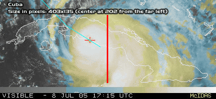
Sorry that it's quick and dirty but back to my question - how does a crossing of Western Cuba support a South Florida hit?
I just want to understand where you're coming from.
|
|
Lysis
|
|
(User)
|
|
Fri Jul 08 2005 06:09 PM
|
|
|
|
|
|
|
|
|
Re: South Fl
|
|
Right now I still think that he will come off east of Havana... a little east of the forcast.
|
|
Jamiewx
|
|
(Storm Tracker)
|
|
Fri Jul 08 2005 06:12 PM
|
|
|
|
|
|
|
|
|
Center location
|
|
This closer image from RAMSDIS is probably better than the floater.
Tropical RAMSDIS
Edit: Link is fixed
|
|
WeatherNLU
|
|
(Meteorologist)
|
|
Fri Jul 08 2005 06:13 PM
|
|
|
|
|
|
|
|
|
Re: making landfall soon
|
|
Quote:
WeatherNLU: I think that what a lot of people are seeing on the WV loops that are causing them to think that this will go more NW/NNW is the fact that the short wave troughs are digging much deeper into the GOM and you CAN see an erosion of the high pressure system just east of Daytona. Clark has talked about this happening, Ed has talked about this happening and so has JK. This was a possibility all along. I'm not saying it's going to happen, but it's not something we can't totally discount. It was also addressed in the 11AM discussion and some of the models are picking up on this.
I just must be blind. I certainly do not see the high eroding at all, at the worst it's holding it's own.
|
|
nccathy
|
|
(Registered User)
|
|
Fri Jul 08 2005 06:14 PM
|
|
|
|
|
|
|
|
|
Re: Center location
|
|
the link doesn't work
|
|
Baudelaire
|
|
(Registered User)
|
|
Fri Jul 08 2005 06:23 PM
|
|
|
|
|
|
|
|
|
Re: Center location
|
|
Wow I feel bad for those people getting beaten with that near category 5 eyewall right now.
|
|
StormDrain
|
|
(Registered User)
|
|
Fri Jul 08 2005 06:24 PM
|
|
|
|
|
|
|
|
|
Re: The eye is ashore
|
|
Everyone I've talked to is having issues with the sats loading. It takes a long time, but once you have it up leave it up and hit refresh for newer images. It took 15 minutes for mine to load, but it did come up. Maybe they are experiencing heavy traffic and it's effecting the site
|
|
jr928
|
|
(Weather Guru)
|
|
Fri Jul 08 2005 06:26 PM
|
|
|
|
|
|
|
|
 Re: South Fl
|
|
Which models predicted ivan and charley best?
|
|
VandyBrad
|
|
(Weather Hobbyist)
|
|
Fri Jul 08 2005 06:28 PM
|
|
|
|
|
|
|
|
|
Re: The eye is ashore
|
|
Wow, the last images on the sats totally loose the eye. It's almost like the eye got obliterated when it hit Cuba.
|
|
|
|
Re: South Fl
|
|
what is th eadress fro the 6 diff models you can run CMC, FSU Etc.. It allows you to run 24,48, 54 hours ahead of time. Anyone know where that is?????
|
|
Liz
|
|
(Weather Watcher)
|
|
Fri Jul 08 2005 06:29 PM
|
|
|
|
|
|
|
|
|
Re: Center location
|
|
Link is working for me. He is HUGE Does anyone know how large he is....how many miles across he is?
Liz
PS....quess I was off about my prediction of the 1st named Hurricane 
|
|
Storm Hunter
|
|
(Veteran Storm Chaser)
|
|
Fri Jul 08 2005 06:31 PM
|
|
|
|
|

|
|
|
Re: The eye is ashore
|
|
i have the floater up all morning and saw what i think were two small vortices inside the eye just before landfall....pretty kewl!
right now appears thw whole eye has made landfall
lastest rapid scan vis
http://hadar.cira.colostate.edu/ramsdis/online/data/rmtcrso/131.jpg
|
|
doug
|
|
(Weather Analyst)
|
|
Fri Jul 08 2005 06:31 PM
|
|
|
|
|
|
|
|
|
Re: making landfall soon
|
|
the high has become eliptical and is eroding to the east, kind of like a flat tire. use the RAMSDIS 14 k WV loop ...link is on the main page.
|
|
spencercape
|
|
(Verified CFHC User)
|
|
Fri Jul 08 2005 06:40 PM
|
|
|
|
|

|
|
|
Re: South Fl
|
|
http://moe.met.fsu.edu/tcgengifs/
---------
SpencerCape
www.techvr.com/weather.htm
|
|
TDW
|
|
(Weather Watcher)
|
|
Fri Jul 08 2005 06:42 PM
|
|
|
|
|
|
|
|
|
Re: Dennis Deepens
|
|
I notice the latest UKMET model now has shifted to landfall along the central Mississippi coast. Hadn't it been an outlier, with landfall in LA?
|
|
Clark
|
|
(Meteorologist)
|
|
Fri Jul 08 2005 06:47 PM
|
|
|
|
|
|
|
|
|
Re: making landfall soon
|
|
New blog posted answering some of the comments about the ridging, its evolution, and the related impacts on the track of Dennis...plus guidance on the model guidance. Hope this helps to clarify any thinking and analysis with regards to the storm at this time.
|
|
|
|
Re: Dennis Deepens
|
|
Quite an impressive buzz-saw hurricane. Hopefully it weakens considerablly over Cuba. Looks more like a NNW track to me, but could just be slight jogs over land.
|
|
WeatherNLU
|
|
(Meteorologist)
|
|
Fri Jul 08 2005 06:51 PM
|
|
|
|
|
|
|
|
|
Re: Dennis Deepens
|
|
Correct, and am I glad to see that!!! I hadn't noticed, but that's a good sign for us here. Now no models have New Orleans taking the eastern side of the storm. We can breathe a little easier.
|
|
ShanaTX
|
|
(Storm Tracker)
|
|
Fri Jul 08 2005 06:51 PM
|
|
|
|
|
|
|
|
|
Re: Dennis Deepens
|
|
From http://news.yahoo.com/news?tmpl=story&u=/ap/20050708/ap_on_re_us/hurricane_dennis_us_7
Quote:
An estimated 40,000 residents and tourists were ordered out of the beachside town of Gulf Shores, Ala., on Friday, and evacuation was also requested in a flood-prone parish south of New Orleans that is home to 458,000. Mississippi officials planned an announcement later in the day.
Inland-bound traffic along the coast was already growing heavy, and hotels were filling more than 150 miles to the north.
"All day long all of our phones have been ringing. The only thing we can tell people is that we are sold out," said Lasonya Lewis, a desk clerk at a Courtyard by Marriott in Montgomery, Ala.
In Florida, some gas stations had run out of fuel Friday, and cars lined up at those that still had supplies. State officials said fuel supplies and distribution were normal, and dry pumps would be restocked by Saturday.
'shana
|
|
|
|
followed coastline before landfall...notice?
|
|
which made Dennis somewhat change it's heading....
land could somewhat change the path...enough to throw the models and everyone into a slight "correction"
it will be interesting to see what path over Cuba Dennis takes....
gusts at 184 over cuba.....around 10:00....can you imagine hunkering down in that?.......
|
|
Lysis
|
|
(User)
|
|
Fri Jul 08 2005 06:58 PM
|
|
|
|
|
|
|
|
|
Re: followed coastline before landfall...notice?
|
|
Could you imagine hunkering down in that?
... Unfortunately, yes.
|
|
Katie
|
|
(Weather Guru)
|
|
Fri Jul 08 2005 06:58 PM
|
|
|
|
|
|
|
|
|
Re: followed coastline before landfall...notice?
|
|
Liz - I heard he was approximately 300 miles across....I could be wrong seeing as how, I heard that on Fox News...
|
|
tornado00
|
|
(Weather Hobbyist)
|
|
Fri Jul 08 2005 06:59 PM
|
|
|
|
|
|
|
|
|
Re: followed coastline before landfall...notice?
|
|
At that speed, there would be nothing to hunker down in.
|
|
Ed in Va
|
|
(Weather Master)
|
|
Fri Jul 08 2005 07:01 PM
|
|
|
|
|
|
|
|
|
Re: followed coastline before landfall...notice?
|
|
So how about a pool on when the eye gets back over water...I'll go with 11:30.
|
|
|
|
Re: followed coastline before landfall...notice?
|
|
Yes, that would be pretty scary. Had our share of Charlie, Francis, & Jeanne last year, all going through out County in Florida (Highlands). No gusts of 180, that is for sure though...
|
|
poetdi
|
|
(Verified CFHC User)
|
|
Fri Jul 08 2005 07:06 PM
|
|
|
|
|

|
|
|
Re: Dennis Deepens
|
|
Hi all - first post for this season - feeling deeply for those in Cuba and all those in Dennis' path.
This link describes Delta's policy on rescheduling airline tickets - thought you might find it interesting given the number of folks posting about whether they should change their travel plans or not. Probably most/all airlines have a similar policy of suspending change penalties due to this storm - a good thing.
http://www.delta.com/travel/before/travel_updates_flight_info/dennis_070605/index.jsp
Diane
|
|
|
|
New category for hurricanes....
|
|
cat 1---hohum
cat 2---shoot
cat 3---ouch
cat 4--outta here
cat 5--nutting left
and for Dennis
cat damn...
|
|
|
 Re: New category for hurricanes....
|
|
Sad but true!
|
|
Lysis
|
|
(User)
|
|
Fri Jul 08 2005 07:11 PM
|
|
|
|
|
|
|
|
|
Re: followed coastline before landfall...notice?
|
|
Charley made landfall here at that exact same intensity (145 mph, 941 mb).
If you are curious... this is comparable to what Cubans near Cienfuegosa are going through right now:
http://www.extremestorms.com/Charlie%20Core-%20Punta%20Gorda.wmv
|
|
|
 Re: New category for hurricanes....
|
|
Does anyone have the web address for the Florida DOT that has the traffic count rates going in and out of Florida?
|
|
MissBecky
|
|
(Weather Guru)
|
|
Fri Jul 08 2005 07:17 PM
|
|
|
|
|
|
|
|
|
Re: New category for hurricanes....
|
|
It just started *pouring* here. Very breezy, too.
|
|
Jenny
|
|
(Verified CFHC User)
|
|
Fri Jul 08 2005 07:18 PM
|
|
|
|
|
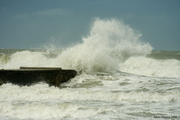
|
|
|
Re: New category for hurricanes....
|
|
http://www3.dot.state.fl.us/trafficinformation/
|
|
tornado00
|
|
(Weather Hobbyist)
|
|
Fri Jul 08 2005 07:18 PM
|
|
|
|
|
|
|
|
|
Re: New category for hurricanes....
|
|
Poetdi, what part of Maitland do you live in? We're probably right under each others noses.
|
|
Liz
|
|
(Weather Watcher)
|
|
Fri Jul 08 2005 07:19 PM
|
|
|
|
|
|
|
|
|
Re: followed coastline before landfall...notice?
|
|
Unbelievable !!!!!
I can't begin to imagine what 184 mph will do.
Liz
|
|
Lysis
|
|
(User)
|
|
Fri Jul 08 2005 07:20 PM
|
|
|
|
|
|
|
|
|
Re: New category for hurricanes....
|
|
Yes, everyone is south Florida take a look at the high cirrus clouds overhead, and the increasingly overcast sky. Southern Florida is already being affected by tropical moisture part of Dennis's circulation. The most amazing thing is track something across thousands of miles, and then see part if it at home… so check it out, and stay aware of what is happening around you and how it plays out in the big scheme of things (I suppose some of us will see more than we would like).
|
|
Katie
|
|
(Weather Guru)
|
|
Fri Jul 08 2005 07:22 PM
|
|
|
|
|
|
|
|
|
Rain, rain go away
|
|
Miss Becky - we just got our second span of rains this afternoon. It came down like cats and dogs and then just as quick as it started - it stopped. And now it is clear again. Pretty breezy too.
|
|
KC
|
|
(Weather Hobbyist)
|
|
Fri Jul 08 2005 07:24 PM
|
|
|
|
|
|
|
|
|
Re: New category for hurricanes....
|
|
Quote:
It just started *pouring* here. Very breezy, too.
We've been experiencing some interesting weather in Naples since about 2pm - brief torrential downpours, thunder and winds to 28mph.
|
|
Katie
|
|
(Weather Guru)
|
|
Fri Jul 08 2005 07:24 PM
|
|
|
|
|
|
|
|
|
Re: New category for hurricanes....
|
|
For the person who asked about FDOT -
http://www.dot.state.fl.us/
|
|
|
|
Re: followed coastline before landfall...notice?
|
|
anyone have any guesses if @ the 5pm there will be more of an eastward shift in the track ? it seems to be a lil off of the nhc track ... :?:
|
|
|
|
Re: Rain, rain go away
|
|
Sounds like we are going to have a nasty TStorm here, but that isn't Hurricane related...
I was surprised how little Lightning there was during the hurricanes we went through last year... Maybe it was muffled by the shingles coming off and slaming against the house...
|
|
jr928
|
|
(Weather Guru)
|
|
Fri Jul 08 2005 07:28 PM
|
|
|
|
|
|
|
|
|
Re: making landfall soon
|
|
why is joe b from accuweather always so doomsday. he' s been predicting new orleans catastrophe everytime one enters the gulf.
|
|
|
 Re: New category for hurricanes....
|
|
Thanks for the information...
According to the traffic count, it looks like that 75 north is starting to pick-up pretty good around Valdosta so it looks like that may be one of the evac routes of choice.
Also TWC reported winds of 149mph near Cienfuegos as well as damage reports saying that there has been significant damage to the telecommunications infrastructure on the island of Cuba.
|
|
Lysis
|
|
(User)
|
|
Fri Jul 08 2005 07:30 PM
|
|
|
|
|
|
|
|
|
Re: Rain, rain go away
|
|
Genneraly, hurricanes don't contain lightning, however it has been observed on rare occasions (I think with the inclusion of dry air, or going over a mountian or something like that).
|
|
nandav
|
|
(Weather Watcher)
|
|
Fri Jul 08 2005 07:31 PM
|
|
|
|
|
|
|
|
|
Re: followed coastline before landfall...notice?
|
|
Thanks for the reminder! Looks like what I saw out our back door! Where was that taken?
|
|
Jamiewx
|
|
(Storm Tracker)
|
|
Fri Jul 08 2005 07:32 PM
|
|
|
|
|
|
|
|
|
NWS MLB AFD
|
|
"SAT...POWERFUL HURRICANE DENNIS WILL BE MOVING ACROSS THE EAST GULF. LATEST TRACK KEEPS TROPICAL STORM FORCE WINDS WEST OF THE AREA. HAVE CONSIDERED ISSUING A WIND ADVISORY AS SUSTAINED WINDS ARE LIKELY TO BE 25-30 MPH...BUT WILL HOLD OFF FOR AT LEAST ONE MORE ADVISORY FROM THE HURRICANE CENTER.
MAIN ISSUE HOWEVER MIGHT TURN OUT TO BE THE CONVECTIVE BANDS ASSOCIATED WITH THE HURRICANE WHICH WILL BE ROTATING ACROSS THE AREA AND BRING THE POTENTIAL FOR WIND GUSTS EXCEEDING TROPICAL STORM FORCE. THE BANDS SHOULD START IN SOUTHERN SECTIONS BY EARLY MORNING AND LIFT TO NORTHERN SECTIONS BY AFTERNOON. WITH STRONG LOW LEVEL SHEAR...THERE IS ALSO A THREAT FOR DAMAGING TORNADOES.
HURRICANE HAS BEEN MOVING NEAR 15 MPH AND IS FORECAST TO MAINTAIN A NEARLY STEADY SPEED. THIS SHOULD LIMIT THE OVERALL RAINFALL AMOUNTS. LOCALLY HEAVY TOTALS OF 3-4 INCHES WILL BE POSSIBLE...WITH THE HEAVIEST AMOUNTS LIKELY NEAREST TO THE CORE OF THE HURRICANE...OVER WESTERN SECTIONS. OF COURSE COASTAL CONVERGENCE EFFECTS COULD LEAD TO AN INTENSE RAINBAND FURTHER EAST TOO. FLASH FLOOD AMOUNTS ARE GENERALLY 3 INCHES FOR ONE HOUR AND 4-5 INCHES FOR
6 HOURS. THEREFORE HAVE OPTED TO NOT ISSUE FLOOD WATCH."
|
|
poetdi
|
|
(Verified CFHC User)
|
|
Fri Jul 08 2005 07:38 PM
|
|
|
|
|
|
|
|
|
Re: New category for hurricanes....
|
|
Quote:
Poetdi, what part of Maitland do you live in? We're probably right under each others noses.
We're in Dommerich Estates - Charley went right over us last year - albeit in a weakened state. No power for 5 days. So many trees came down.
I know that many folks have had it so much worse than us, since we are so far inland. We are not happy about any storm but are glad this one appears to be staying away from us. 
Diane
|
|
|
|
Re: making landfall soon
|
|
Well, then, Shawn...I guess you should read Clark's latest met blog because he says almost exactly what I said and you discounted that.
I may not be a met, but I do have eyes and I can see things happening.
Now I'm dropping the subject because either it will or won't happen.
|
|
pcola
|
|
(Storm Tracker)
|
|
Fri Jul 08 2005 07:42 PM
|
|
|
|
|
|
|
|
|
Re: making landfall soon
|
|
The models all seem to be coming together between Panama City and Biloxi
|
|
|
|
Clouds are moving in
|
|
You can see the clouds coming from the south. It is just a matter of time before we start to see some rain.
|
|
jr928
|
|
(Weather Guru)
|
|
Fri Jul 08 2005 07:45 PM
|
|
|
|
|
|
|
|
|
Re: making landfall soon
|
|
You guys remember the hurricane that did a full 360 a few years back. Not many models had that in store either. Models are just that, MODELS.
|
|
KC
|
|
(Weather Hobbyist)
|
|
Fri Jul 08 2005 07:47 PM
|
|
|
|
|
|
|
|
|
Re: making landfall soon
|
|
A tornado watch (probably the first of who knows how many) was just issued for Collier, Miami-Dade and Monroe Counties until tomorrow morning.
|
|
Baudelaire
|
|
(Registered User)
|
|
Fri Jul 08 2005 07:47 PM
|
|
|
|
|
|
|
|
|
Re: making landfall soon
|
|
Quote:
You guys remember the hurricane that did a full 360 a few years back. Not many models had that in store either. Models are just that, MODELS.
That's what I'm saying.
|
|
rmbjoe1954
|
|
(Weather Master)
|
|
Fri Jul 08 2005 07:48 PM
|
|
|
|
|
|
|
|
|
Re: making landfall soon
|
|
I remember Gordon returning to Florida from the Carolinas.
|
|
Katie
|
|
(Weather Guru)
|
|
Fri Jul 08 2005 07:49 PM
|
|
|
|
|
|
|
|
|
Re: making landfall soon
|
|
What about Jeanne last year doing a completely loop-de-loop out there in the Atlantic before she figured out where she wanted to vacation.
|
|
jr928
|
|
(Weather Guru)
|
|
Fri Jul 08 2005 07:50 PM
|
|
|
|
|
|
|
|
|
Re: making landfall soon
|
|
Joe B says this time next week we'll be discussing another storm heading for the US coasts.
|
|
Rasvar
|
|
(Weather Master)
|
|
Fri Jul 08 2005 07:53 PM
|
|
|
|
|
|
|
|
|
Re: making landfall soon
|
|
Actually, if you are talking about the 360 that Jeanne made last year, most of the major models had seen it at one time or another. [Those models were the main reasons I left my boards up until Jeanne passed]
I still feel that this is a Mobile bay to Biloxi storm. However, I do not think NO is in the clear. Can not really judge based on the motion over land. Will get a better idea when he clears into to the Gulf tomorrow. I am having a hard time see a hard enough turn to really get anything but the lower Keys in the southern part of the state. I think that will only be a swipe of 70-90MPH winds. I think he will clear most of the West Florida coast by 150-200 miles. I just do not see a faster turn happening.
Granted, I would still double check my plans if I was on the West Florida coast.
|
|
rmbjoe1954
|
|
(Weather Master)
|
|
Fri Jul 08 2005 07:54 PM
|
|
|
|
|
|
|
|
|
Re: making landfall soon
|
|
I know. Take a look at what is about to enter the Carribean from the Windwards. And than there's the wave that came off Africa; by the way, how is that wave? 
|
|
nandav
|
|
(Weather Watcher)
|
|
Fri Jul 08 2005 07:54 PM
|
|
|
|
|
|
|
|
|
Re: Clouds are moving in
|
|
We just had some heavy rain in S. Ft Myers, & now it's really windy..dark.. time to head home, I think..
|
|
spencercape
|
|
(Verified CFHC User)
|
|
Fri Jul 08 2005 07:55 PM
|
|
|
|
|
|
|
|
|
Re: making landfall soon
|
|
And let me guess, Joe B says this next storm is headed directly for N.O., LA?
|
|
|
|
Re: making landfall soon
|
|
No he has been hyping the "Short Cut" Storm. Mid Atlantic States is where he thinks the action will be next..
|
|
palmetto
|
|
(Verified CFHC User)
|
|
Fri Jul 08 2005 07:57 PM
|
|
|
|
|
|
|
|
|
Re: making landfall soon
|
|
Hey, if he keeps guessing NO, he might actually guess right one day.
|
|
pcola
|
|
(Storm Tracker)
|
|
Fri Jul 08 2005 08:00 PM
|
|
|
|
|
|
|
|
|
Re: making landfall soon
|
|
i wish I knew where the FSU Suoerensamble was pointing..that one has been very good the last 4 storms.
|
|
WeatherNLU
|
|
(Meteorologist)
|
|
Fri Jul 08 2005 08:01 PM
|
|
|
|
|
|
|
|
|
Re: making landfall soon
|
|
Quote:
Well, then, Shawn...I guess you should read Clark's latest met blog because he says almost exactly what I said and you discounted that.
I may not be a met, but I do have eyes and I can see things happening.
Now I'm dropping the subject because either it will or won't happen.
LOL! Why is everyone around here so combative? I don't know what you do for a living but it really doesn't matter. I'd like to think I know a little bit about the subject after studying it for four years in college and many more since. I know Clark and believe me I respect every word that he says......however......him saying it doesn't make it good as gold and me thinking otherwise is part of the business. If we all thought the same, that would be pretty boring. Anyway, I am not here to argue, only give my opinion........take it for what it's worth.
|
|
spencercape
|
|
(Verified CFHC User)
|
|
Fri Jul 08 2005 08:01 PM
|
|
|
|
|
|
|
|
|
Re: making landfall soon
|
|
Mathematically, it's not likely.
Of course, if Dennis ends up in NO vs a bit closer to me here in SW FL (and I've thought a FL landing since the beginning), then I'll give him his credit, but I think I am safe for now.
-------------------------
SpencerCape
www.techvr.com/weather.htm
|
|
|
|
Re: making landfall soon
|
|
Quote:
You guys remember the hurricane that did a full 360 a few years back. Not many models had that in store either. Models are just that, MODELS.
You talking about Hurricane Elaina. It went to the W coast of Fl did a batman turn and came into Ms.
|
|
spencercape
|
|
(Verified CFHC User)
|
|
Fri Jul 08 2005 08:04 PM
|
|
|
|
|
|
|
|
|
Re: making landfall soon
|
|
Here's the FSU site.... it's pointing central panhandle at the miday run....
http://moe.met.fsu.edu/mm5/
----------------------
SpencerCape
www.techvr.com/weather.htm
|
|
pcola
|
|
(Storm Tracker)
|
|
Fri Jul 08 2005 08:06 PM
|
|
|
|
|
|
|
|
|
Re: making landfall soon
|
|
That is the mm5...not the superensamble....correct?
|
|
WeatherNLU
|
|
(Meteorologist)
|
|
Fri Jul 08 2005 08:07 PM
|
|
|
|
|
|
|
|
|
Re: making landfall soon
|
|
That's the MM5, Clark can explain better but it's not the SE.
|
|
|
|
fsu
|
|
superensamble is private eyes only.
|
|
|
|
Re: making landfall soon
|
|
Hey you all.... posting links is fine but try to use the PM feature for the short questions to one another instead of posting them. Thanks
|
|
spencercape
|
|
(Verified CFHC User)
|
|
Fri Jul 08 2005 08:11 PM
|
|
|
|
|
|
|
|
|
Re: making landfall soon
|
|
yes yes, you're right I sent the wrong link...apologies.
|
|
Jamiewx
|
|
(Storm Tracker)
|
|
Fri Jul 08 2005 08:20 PM
|
|
|
|
|
|
|
|
|
Re: making landfall soon
|
|
Wind advisory is now in effect for all of East Central Florida, check you local NWS forecast for specifics. In the MLB AFD they was going to wait for the 5pm package from the NHC before issuing this advisory, so obviously they know the details of the 5pm advisory and the track has not changed much.
|
|
Dougyd
|
|
(Verified CFHC User)
|
|
Fri Jul 08 2005 08:23 PM
|
|
|
|
|
|
|
|
|
Re: making landfall soon
|
|
I don't see any local folks watching but if you are in SW FL, check out this site.
doug
http://www.intellicast.com/Local/USLocal...mp;prodnav=none
|
|
tornado00
|
|
(Weather Hobbyist)
|
|
Fri Jul 08 2005 08:28 PM
|
|
|
|
|
|
|
|
|
Re: making landfall soon
|
|
Poetdi, I live about 5 minutes away from you in Maitland Club on Wymore. What a coincidence.
|
|
pcola
|
|
(Storm Tracker)
|
|
Fri Jul 08 2005 08:28 PM
|
|
|
|
|
|
|
|
|
Re: making landfall soon
|
|
Since landfall the Key West radar loop appears to show Dennis going west-northwest. That will keep it on land much longer. Hopefully decreasing the intensity.
|
|
tornado00
|
|
(Weather Hobbyist)
|
|
Fri Jul 08 2005 08:30 PM
|
|
|
|
|
|
|
|
|
Re: making landfall soon
|
|
Sorry about that Storm Trooper for sending short messages around the board like that. The person I'm sending it too doesn't have the PM module working. 
Storm Cooper
|
|
FireAng85
|
|
(Weather Hobbyist)
|
|
Fri Jul 08 2005 08:30 PM
|
|
|
|
|
|
|
|
|
Re: making landfall soon
|
|
Hey Poetdi and whoever else is in Maitland, I live in Sorrento and work in Apopka. Pretty close, huh?
|
|
Katie
|
|
(Weather Guru)
|
|
Fri Jul 08 2005 08:32 PM
|
|
|
|
|
|
|
|
|
Re: making landfall soon
|
|
Well, I am going to try to sneak over to my grandfather's house this weekend so i can check in. Still haven't ordered a new computer yet, but if I don't make it before he hits - best of luck to anyone in his path. Be safe and be careful.
Hoping for the best.
|
|
MikeC
|
|
(Admin)
|
|
Fri Jul 08 2005 08:36 PM
|
|
|
|
|
|
|
|
|
Re: making landfall soon
|
|
Dennis is over land still for the most part moving along the NHC's track. I hope it doesn't slow or stall in the Gulf. I don't think it will stall anyway. It's still going to rain here quite a bit in Central Florida, I think, and the pressure gradients will keep it a little breezy tomorrow and sunday.
It's ok, I'm living in Maitland (well on the maitland/altamonte border) too just off Mailtland Blvd and 434. But yea, that's off topic. Move that to the E/N forum.
|
|
|
|
Re: making landfall soon
|
|
Well..here's a weather update from Central Florida. I went to pick up my kids, and we just had a feeder band come through (at least that's what they're calling it on the local wx stations) that dropped at LEAST 1" of rain here. The trees were bending over quite a bit with the winds blowing so hard and the lightning was pretty intense. Also noticed that the rain was sideways, then blowing s/n, then back to n/s. The temperature in my car dropped from 97 to 69 in about 15 minutes time. I've driven through a lot of storms here, and I've never seen it drop THAT much.
If this is an indication of things to come, I'm not looking forward to it.
Not that anyone else is, either.
|
|
nandav
|
|
(Weather Watcher)
|
|
Fri Jul 08 2005 08:42 PM
|
|
|
|
|
|
|
|
|
Re: making landfall soon
|
|
The link that DougYD posted shows that what you just had and what we are seeing here in SW Florida are definitely feeder bands... imho
|
|
SkeetoBite
|
|
(Master of Maps)
|
|
Fri Jul 08 2005 08:44 PM
|
|
|
|
|
|
|
|
|
Re: making landfall soon
|
|
Colleen,
I was wondering if you were around to notice that. Absolutely the most energetic little piece of activity we've had so far this year. That was crazy.
|
|
rmbjoe1954
|
|
(Weather Master)
|
|
Fri Jul 08 2005 08:47 PM
|
|
|
|
|
|
|
|
|
Re: making landfall soon
|
|
It's going to be a wet and windy weekend for us in East Central Florida. Hold on to your hats in West Florida!
|
|
|
|
Re: making landfall soon
|
|
belle isle here - need admin work, let me know.
|
|
KC
|
|
(Weather Hobbyist)
|
|
Fri Jul 08 2005 08:48 PM
|
|
|
|
|
|
|
|
|
Re: making landfall soon
|
|
5pm update has been posted on wunderground.com.
|
|
FlaMommy
|
|
(Storm Tracker)
|
|
Fri Jul 08 2005 08:48 PM
|
|
|
|
|
|
|
|
|
Re: making landfall soon
|
|
Well here in Riverview we just got a little taste of the first band....and it rained for like a second literally...and now it has stopped....although on the radar we are expected a pretty intense storm....i hope all is safe and DENNIS STAY THE H*LL AWAY FROM US!!!!
|
|
|
|
Re: making landfall soon
|
|
5pm is out
WHILE SOME WOBBLING HAS CONTINUED TO OCCUR...AS IS TYPICAL OF A
MAJOR HURRICANE...DENNIS IS EXPECTED TO GENERALLY MOVE TOWARD THE
NORTHWEST NEAR 17 MPH...28 KM/HR. ON THIS TRACK...THE CENTER
SHOULD EMERGE OFF THE NORTH-CENTRAL COAST OF CUBA THIS EVENING.
MAXIMUM SUSTAINED WINDS HAVE DECREASED TO NEAR 135 MPH...215
KM/HR...WITH HIGHER GUSTS. ALTHOUGH DENNIS IS STILL A CATEGORY 4
HURRICANE ON THE SAFFIR-SIMPSON SCALE...SOME ADDITIONAL WEAKENING
IS FORECAST AS DENNIS MOVES OVER CUBA. HOWEVER...DENNIS IS EXPECTED
TO REMAIN A MAJOR HURRICANE AS IT EMERGES OVER THE STRAITS OF
FLORIDA AND THE SOUTHEASTERN GULF OF MEXICO THIS EVENING.
HURRICANE FORCE WINDS EXTEND OUTWARD UP TO 65 MILES...100 KM...
FROM THE CENTER...AND TROPICAL STORM FORCE WINDS EXTEND OUTWARD UP
TO 160 MILES...260 KM. EARLIER THIS AFTERNOON AS DENNIS MADE
LANDFALL ALONG THE SOUTH-CENTRAL COAST OF CUBA...A SUSTAINED WIND
OF 99 MPH...160 KM/HR...WITH A GUST WIND GUST TO 149 MPH...240
KM/HR...WAS MEASURED IN CIENFUEGOS...AND EXTENSIVE DAMAGE WAS ALSO
REPORTED.
THE ESTIMATED MINIMUM CENTRAL PRESSURE IS 949 MB...28.02 INCHES.
|
|
|
|
Re: making landfall soon
|
|
Yes, and every minute or so, the thunder is rumbling, brief downpour, gusts and then it stops. This is worse than what we got with Charley...my kids are hiding in the closet already! It completely flooded out the street I turn onto (Lake Seward) to go into my subdivision. And we're only supposed to get 1-3" or rain??? I don't think so....
|
|
pcola
|
|
(Storm Tracker)
|
|
Fri Jul 08 2005 08:54 PM
|
|
|
|
|
|
|
|
|
Re: making landfall soon
|
|
Well, the 5pm track is pretty much the same as it has been for 4 days..westen panhandle......
|
|
OcalaKT
|
|
(Weather Watcher)
|
|
Fri Jul 08 2005 08:55 PM
|
|
|
|
|

|
|
|
Re: making landfall soon
|
|
Quote:
You guys remember the hurricane that did a full 360 a few years back. Not many models had that in store either. Models are just that, MODELS.
I think that was Betsy, sometime in the 60's. She passed by Miami out in the Atlantic, went up even with Jacksonville, then did a 360 and came back and hit Miami, then went out into the Gulf and went up and hit Louisiana, I think. I went through Besty as a little girl.
|
|
|
|
Cool page of auto-updated images
|
|
here is a link to an interesting page I found last year (might have found it here). It has a large collection of current images that are auto-updated.
http://www.geocities.com/tropicwx/
Yes - my name is actually Dennis
|
|
jr928
|
|
(Weather Guru)
|
|
Fri Jul 08 2005 09:08 PM
|
|
|
|
|
|
|
|
 Re: making landfall soon
|
|
yes, betsy it was!
|
|
|
|
Re: making landfall soon
|
|
Had it here too...made the power surge off twice already.
|
|
Storm Hunter
|
|
(Veteran Storm Chaser)
|
|
Fri Jul 08 2005 09:15 PM
|
|
|
|
|
|
|
|
|
Re: Cool page of auto-updated images
|
|
read 5pm disc......
take a look over texas and the ohio valley (WV image)
http://hadar.cira.colostate.edu/ramsdis/online/data/rmtcrso/79.jpg
web site with more links
i think some shear will begin to effect the storm starting late, saturday, but i am starting to think that Mobile-Pensacola may be a little far west. I am going to go with Navarre to Destin landfall right now and will make one last call when the recon data from today gets into tonights model runs.... I have a hunch that an ULL near the texan coast with help push the storm to the NW more....problem is, where will the weakness in the ridge be for dennis when he hits the GOM and moves on a nw movement.......
here's good florida vis shot...
http://adds.aviationweather.gov/satellit...g&itype=vis
look at the T-storms over florida
|
|
Dawn
|
|
(Weather Watcher)
|
|
Fri Jul 08 2005 09:28 PM
|
|
|
|
|
|
|
|
|
Re: making landfall soon
|
|
Please you all - give me some guidance- I am so tired after making my parents and the customers at Home Depot happy, do I really need to worry or can I rest a minute before I secure our house. 27.88N x 82.87W. I have everything at home to live for five days but do I need more. Do I finish dropping the anwings or are we going be OK. My husband works with Hospice and won't be home till after the storm. It is up to me-please if you lived in St Petersburg would you worry?
|
|
jth
|
|
(Storm Tracker)
|
|
Fri Jul 08 2005 09:29 PM
|
|
|
|
|
|
|
|
|
Re: Cool page of auto-updated images
|
|
I agree. I don't think the NW motion is in much doubt anymore. Now it really will just depend on a wobble here or there to determine exact landfall location. NHC is beginning to have much less doubt as per the last discussion. That ULL over LA moving south is providing an even better avenue for a NW motion. Look for landfall between Mobile and PCB. f I had to pinpoint, I would stick with Destin. Local mets here in Bham are hyping significant damage throughout the state if Dennis goes in around Gulf Shores and moves NNW.
|
|
trinibaje
|
|
(Weather Guru)
|
|
Fri Jul 08 2005 09:30 PM
|
|
|
|
|
|
|
|
|
MIAMI CHECK IN
|
|
experiencing a band of rain through downtown right now..... very heavy and high winds. 
|
|
|
|
Re: Cool page of auto-updated images
|
|
looks interesting HUNTER more interesting if by any chance Denise slows down
|
|
|
|
Re: making landfall soon
|
|
I would say get ready for some heavy rains and some tropical storm force winds. I think you`ll be alright. Listen to your local METS and keep tuned to CFHC....Weatherchef
|
|
jth
|
|
(Storm Tracker)
|
|
Fri Jul 08 2005 09:38 PM
|
|
|
|
|
|
|
|
|
Chat Room
|
|
I bet the chat room is kickin tonight!
|
|
|
|
watch track for the last two or three hours....
|
|
it's going more west of nw....kinda feel like it'll leave Cuba more west than the tracks have forecasted...which will ultimately mean everything will shift west...
i sure hope not...
|
|
MichaelA
|
|
(Weather Analyst)
|
|
Fri Jul 08 2005 09:40 PM
|
|
|
|
|

|
|
|
Re: making landfall soon
|
|
Quote:
Please you all - give me some guidance- I am so tired after making my parents and the customers at Home Depot happy, do I really need to worry or can I rest a minute before I secure our house. 27.88N x 82.87W. I have everything at home to live for five days but do I need more. Do I finish dropping the anwings or are we going be OK. My husband works with Hospice and won't be home till after the storm. It is up to me-please if you lived in St Petersburg would you worry?
I'd remain vigilant this evening and early tomorrow just to see if the forecast track is verifying before making major storm preparations in Pinellas County (that's my plan). I can batten down in an hour if things require that.
|
|
FJVargas
|
|
(Registered User)
|
|
Fri Jul 08 2005 09:49 PM
|
|
|
|
|
|
|
|
|
Re: making landfall soon
|
|
they just talked about flhurricane.com on MSNBC...
|
|
MikeC
|
|
(Admin)
|
|
Fri Jul 08 2005 09:59 PM
|
|
|
|
|
|
|
|
|
Re: making landfall soon
|
|
New thread at the top. Yeah, found out about MSNBC too. I can take that and a slashdotting this year, so go for it.
|
|
LizL
|
|
(Verified CFHC User)
|
|
Fri Jul 08 2005 09:59 PM
|
|
|
|
|
|
|
|
|
Re: making landfall soon
|
|
i just saw a weather loop looks like we might get a bir more than they say.. but i am no weather expert but it worries me .
|
|
|
|
Re: making landfall soon
|
|
Mike has started a new thread.
|