MikeC
|
|
(Admin)
|
|
Fri Jul 08 2005 09:53 PM
|
|
|
|
|
|
|
|
 Dennis Over Cuba
|
|
Original Update
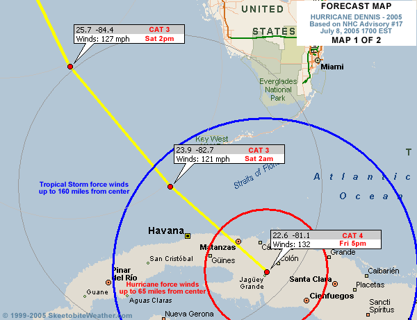
Hurricane Dennis, weakinging ever so slightly is moving rather quickly over Cuba, and is nearing Havana. The ridge north of Central Florida has held, which keeps the forecast track in check as is.
Jim Williams is doing an audio show tonight over at Hurricane City if you have real player, you can listen in With this link

Click for 8AM - 8PM loops of Cuban Radar
Central Florida will see winds tomorrow, but not quite tropical storm force, while the west coast of Florida will see tropical storm force winds. In fact, tropical storm watches are up along a lot of the west coast just for this reason. The Lower Keys may see hurricane force winds tonight and tomorrow.
Beyond that, the western Florida panhandle and northern Gulf coast -- Apalachicola west toward New Orleans -- is the real focus area, with the most likely path taking it near Pensacola as the landfall point. This would put it and points east in the worst part of the storm. Hurricane watches are now up for most of the aforementioned areas because of Dennis. This means everyone in the watch area needs to be prepared for the storm. Landfall is still forecast for sometime on Sunday.
 

I'm looking for good Dennis related links to place on the front page; this includes good images, radar, satellite, streaming audio,video, emergency information, etc. Reply and let us know.
Site Note News talkbacks are now in lockdown mode, which means that unregistered users cannot reply.
You can still post in the other forums besides talkbacks. This enables us to moderate a lot better. I hate doing this, but I can see obvious signs of "storm stress" on a few individuals. We'll make it open again as soon as it calms down.
Registration is open for anyone, you can register Using this link. Then you will be able to reply here.
Hopefully this will only last a short time.
Event Related Links
Emergency Management
Gulf Coast Storm Alert Network
FloridaDisaster.org - Florida Emergency Management
Monroe County/Florida Keys,
Panhandle Coastal Counties West to East
Escambia County, FL, Santa Rosa, County, Okaloosa County, FL,
Walton County, FL,
Bay County, FL, Gulf County, FL, Franklin County, FL...
StormCarib hurricane reports from observers in the Islands - Jamaican StormCarib Reports
Caribbean Island Weather Reports
Guantanamo Bay, Cuba Radar
Florida Keys Long Range Radar Loop
Tampa Bay, FL Long Range Radar
Miami, FL Long Range Radar
Melbourne, FL Long Range Radar
Tallahassee, FL Long Range Radar
Mobile, AL Long Range Radar
Casablanca, Cuba Radar
Dennis
High Speed Storm Relative Floater - RAMSDIS ONLINE
Animated Model Plot of Dennis
Model Plot Graphic from the South Florida Water Management District of Dennis
Dennis Spaghetti Model from boatus
Weather Underground Model Plots for Dennis
Quikskat Image of Dennis
Color Sat of Dennis
Floater Satellite (Visible) of Dennis with Storm Track Overlays
Cienfuegosa, Cuba Radar - (Animated)
RAMSDIS high speed visible Floater of Dennis
Webcams, Video, Audio
Mark Sudduth's at coastal Alabama again ready to move east or west, he has a mobile observation tower he'll be leaving along the coast when Dennis arrives - Hurricane Trak/Mark Suddth Car & Tower Cam
Suncam.tv's collection of Dennis cam's and Mobile (not the city) cams - Suncam.tv's Moble Car Cam
Hurricane City and Jim Williams do audio shows nightly around 8PM
Joseph Johnston's Mobile Bay Webcam
Key West Webcams
New Orleans webcams
Radio Habana, Cuba
Forecast Discussions for (Show All Locations):
Tampa, Mobile Bay,
New Orleans, Key West, Tallahassee.
Melbourne
|
|
Dougyd
|
|
(Verified CFHC User)
|
|
Fri Jul 08 2005 10:03 PM
|
|
|
|
|
|
|
|
|
Re: Dennis Over Cuba
|
|
If you are in South Florida, check this site.
doug
http://www.intellicast.com/Local/USLocal...mp;prodnav=none
|
|
trinibaje
|
|
(Weather Guru)
|
|
Fri Jul 08 2005 10:08 PM
|
|
|
|
|
|
|
|
|
Re: Dennis Over Cuba
|
|
Quote:
If you are in South Florida, check this site.
doug
http://www.intellicast.com/Local/USLocal...mp;prodnav=none
link is bad
|
|
|
|
Re: Dennis Over Cuba
|
|
Yeah tell me about it. There is a line of storms headed to Broward Cnty with gusts reported to 60mph in part of Miami-Dade. We are under a Severe Thunderstorm warning.
|
|
nl
|
|
(Storm Tracker)
|
|
Fri Jul 08 2005 10:12 PM
|
|
|
|
|

|
|
|
Re: Dennis Over Cuba
|
|
what is that big low thats on the floater?
|
|
|
|
Re: Dennis Over Cuba
|
|
Hey everybody..sorry...this is my first time on here trying to communicate so let me know if I screw it up or something. I live in Ellenton, FL. My 83 year old Dad lives in Port Charlotte and survived Charley last year. Any indication that we will have another "Right Turn Clyde" with Dennis?
not really. pretty confident the east central gulf gets it. you guys aren't quite in the green, but you sure aren't in the red. -HF
|
|
ShanaTX
|
|
(Storm Tracker)
|
|
Fri Jul 08 2005 10:15 PM
|
|
|
|
|
|
|
|
|
Re: Dennis Over Cuba
|
|
And if you're in the New Orleans area:
WWLTV has a lot of info - traffic, sandbag and video updates, Parish by Parish info, hotel
NOLA.com has upto the minute tropical newsflashes
'shana
|
|
Ron Basso
|
|
(Storm Tracker)
|
|
Fri Jul 08 2005 10:15 PM
|
|
|
|
|

|
|
|
Re: Dennis on Key West Short Range 88D
|
|
Check out the cool radar animation from the following link. You can just start to make out the northern eyewall on the Key West short range radar. Looks awesome.
http://www.srh.noaa.gov/radar/loop/DS.p19r0/si.kbyx.shtml
|
|
|
|
Re: Dennis Over Cuba
|
|
"UPPER-AIR DATA AT 12Z AND 18Z INDICATE THE MID-LEVEL
SUBTROPICAL RIDGE ACROSS NORTH-CENTRAL FLORIDA HAS CHANGED LITTLE
TODAY. ALSO...UPPER-AIR DATA INDICATE A COLD POOL OF -10C HAS
DEVELOPED OVER NORTHERN LOUSIANA ALONG A 500 MB TROUGH AXIS...WHICH
NONE OF THE MODELS INTIALIZED VERY WELL. THE COLDER AIR ALOFT
SHOULD HELP CREATE A SLIGHTLY STRONGER MID- TO UPPER-LEVEL LOW THAN
THE GLOBAL...GFDL...AND NAM MODELS ARE FORECASTING TO DROP SOUTH OF
LOUSIANA OVER THE NOTHWESTERN GULF. THE RESULT SHOULD BE A DEEP-
LAYER SOUTHEASTERLY STEERING FLOW REMAINING OVER THE EASTERN GULF
OF MEXICO THROUGHOUT THE FORECAST PERIOD. THE OFFICIAL FORECAST
TRACK IS SIMILAR TO THE PREVIOUS TRACK."
Does anyone know what they are talking about from the 5pm discussion? They went a little above my expertise.
|
|
Unregistered User
|
|
(Unregistered)
|
|
Fri Jul 08 2005 10:23 PM
|
|
|
|
|
|
|
|
|
Re: Dennis on Key West Short Range 88D
|
|
Some Key West web cams...
|
|
LizL
|
|
(Verified CFHC User)
|
|
Fri Jul 08 2005 10:23 PM
|
|
|
|
|

|
|
|
Re: Dennis Over Cuba
|
|
I personally have a strange feeing that it will get up towards right turn clyde and clam the upper west coast of florida above tamp area. that would be a awful scenario. but i am just going on a gut feeling.
|
|
|
|
re-emergence
|
|
the wnw/nw wobbles aren't in any way predictable, but best guess is that the center moves back offshore around 9-10 tonight between matanzas and havana. radar imagery makes it seem like the inner core is doing fine... but it's been on coastal lowlands all afternoon. some hill country to cross this evening before it can re-emerge.. probably cat 2/3 area with a pressure up around 965 when it goes back offshore. that concentric eyewall thing looks like it has more or less completed, so i reckon the shot cuba had at wrecking the inner core is past.
the forecast path stays glued to the fl/al border area. for two days the official has been kept there while the models have leaned back and forth around it. only folks who can really call themselves out of the woods are on the florida peninsula, where nothing worse than rainbands will keep it unsettled.
one good note in all this is that dennis seems to be targetting the area of coolest ssts in the gulf--we may see it inch back up to category 4, but not very likely it will landfall as one. category 3 looks most likely right now.
wave in the east altantic near 30-35w is quite active. nhc isn't mentioning it in the two, but the way things look they won't be able to ignore it for long. i have a feeling this one will be something luis can get krunked over.
if i was inland near the confluence of the ohio and mississippi rivers, i'd get ready for some serious rains. it isn't wholly consistent, but there has been enough model support for stalling/looping/slow, erratic movement of dennis inland around july 13-15 to take heed. inland flooding has been the big killer from tropical systems in the u.s. for the last 30 years or so; dennis has the potential to be both a drought-ender and a major flood event in the midsouth.
HF 2324z08july
|
|
|
|
Re: Dennis Over Cuba
|
|
It is basically saying that the high pressure over Florida is going to point the hurricane in the direction of the Northern Gulf Coast, and that little has changed in the atmosphere to keep it from going in the forecasted direction. But, do not rule out any directional changes until the eye re-emerges from Cuba and has had time to intensify if it is going to. The changes have very little to do with how much rain florida is going to get. The eye of the hurricane is what is tracked and is influenced or not influenced by differing changes in the atmosphere to its north. The higher pressures will influence speed and forward movement of the eye. All of it is subject to greater or lesser pressures.
|
|
Clark
|
|
(Meteorologist)
|
|
Fri Jul 08 2005 10:26 PM
|
|
|
|
|
|
|
|
|
Re: Dennis Over Cuba
|
|
What it means is that the models did not initialize (represent) the mid & upper level feature currently over eastern Texas quite to the strength that the observations show. That would suggest that it might have a stronger impact on the storm than the models are predicting...or that the response could be otherwise entirely different, we really don't know yet. It is the big player with regards to the storm, however, and is something being watched very closely by the NHC, NWS offices, as well as many others.
It also states that the ridge has largely remained unchanged during the day -- changes may be coming, but they are slow in doing so. This isn't any different than the forecasts, however.
|
|
ShanaTX
|
|
(Storm Tracker)
|
|
Fri Jul 08 2005 10:30 PM
|
|
|
|
|
|
|
|
|
Re: Dennis on Key West Short Range 88D
|
|
New Orleans webcams
Gulf Coast Storm Alert Network
|
|
nl
|
|
(Storm Tracker)
|
|
Fri Jul 08 2005 10:31 PM
|
|
|
|
|
|
|
|
|
Re: Dennis Over Cuba
|
|
so what u are saying is that the front from texas is stronger? tom terry on wftv here said it wont be a strong front. im not counting us out unitl it passes tampa. 
|
|
|
|
Re: Dennis on Key West Short Range 88D
|
|
Here is one right on Duval Street, the others did not open for me http://www.liveduvalstreet.com/live-duval-cam.htm
|
|
NewWatcher
|
|
(Storm Tracker)
|
|
Fri Jul 08 2005 10:35 PM
|
|
|
|
|

|
|
|
Re: Dennis Over Cuba
|
|
stupid question clark, but any idea when we will know something more significant
about the texas thing and its relationship to good ole dennis?
|
|
Ed G
|
|
(Weather Hobbyist)
|
|
Fri Jul 08 2005 10:36 PM
|
|
|
|
|
|
|
|
|
Re: Dennis on Key West Short Range 88D
|
|
Moderators, et al...
hasn't the time come to quit the "gut feeling" posts and concentrate on facts?
Just throwing out a thought.
Ed G
Clermont, Fl
|
|
|
|
warnings
|
|
the hurricane warning in the lower keys may be downgraded later this evening.. don't think they'll see any sustained hurricane winds (maybe some gusts close to hurricane force, though). i'm not sure how much longer this wnw jog will take it, but it seems to be going wide enough of the keys that they'll escape serious conditions.
HF 2337z08july
|
|
Ron Basso
|
|
(Storm Tracker)
|
|
Fri Jul 08 2005 10:40 PM
|
|
|
|
|
|
|
|
|
Re: Dennis Over Cuba
|
|
Quote:
What it means is that the models did not initialize (represent) the mid & upper level feature currently over eastern Texas quite to the strength that the observations show. That would suggest that it might have a stronger impact on the storm than the models are predicting...or that the response could be otherwise entirely different, we really don't know yet. It is the big player with regards to the storm, however, and is something being watched very closely by the NHC, NWS offices, as well as many others.
It also states that the ridge has largely remained unchanged during the day -- changes may be coming, but they are slow in doing so. This isn't any different than the forecasts, however.
Clark, thx for the explanation. Was this the situation you've been refering to since midnight last nite? That the models were underestimating the strength of the Upper Trof dropping into the western Gulf? I didn't understand the NHC discussion when the commentator said that this would maintain a "deep southeasterly flow over the eastern gulf". In my mind, it would erode the ridge more than the models anticipate and cause more of a northward motion. Am I correct in that logic?
|
|
Rich B
|
|
(British Meteorologist)
|
|
Fri Jul 08 2005 10:45 PM
|
|
|
|
|
|
|
|
|
Re: warnings
|
|
Dennis seems to be holding together quite well over Cuba, with the ye still quite discernable on the radar imagery, but not so evident on the satellite imagery. Loks like he will emnerge into the GOM as a Cat 3 - a little stronger than i anticpated earlier. Looks like most of the Florida west coast is gonna at least see Tropical Storm force gusts, if not sustained. The Keys, especially Key West, look set to just miss out on sustained hurricane winds, but expect plenty of Hurricane force gusts here. The real problem will be Sunday, as Dennis approaches land. Much of the FL big bend and panhandle look set to get swamped by really quite large waves, combined with onshore flows and storm surges. If Dennis moves inland east of Mobile, AL, then the bay will be out of the woods really. However, if he moves in to the west of Mobile, then Mobile Bay will certainly see a huge rise in water level, and will see some pretty severe flooding.
|
|
Clark
|
|
(Meteorologist)
|
|
Fri Jul 08 2005 10:46 PM
|
|
|
|
|
|
|
|
|
Re: Dennis Over Cuba
|
|
To answer three questions in the thread...
We will know more tomorrow about the evolution of the flow pattern as it relates to Dennis, both with the ridge and the trough.
It is not necessarily a cold front passing through Texas, but is an upper-level feature.
The stronger trough was alluded to last night, yes. It could dive south, it could move east, or it could move southeast. All have different results towards the track, whether taking the storm north, north-northwest, or northwest (not in any order) to landfall. It'd probably erode the ridge more than the models indicate, but you also have to keep in mind the possibility that the ridge ends up being stronger than the models indicate. That may not be the case, but is always a possibility until proven otherwise.
|
|
jth
|
|
(Storm Tracker)
|
|
Fri Jul 08 2005 10:46 PM
|
|
|
|
|
|
|
|
|
ULL over TX
|
|
The discussion mentioned that if this dips down in the gulf as expected, the winds around it will maintain or even enhance the SE flow and keep Dennis on the NW track.
|
|
|
|
Re: Dennis Over Cuba
|
|
I think we are are all hoping the ridge over Florida stays in place long enough to allow Dennis to pass us because the -10c in LA that has developed could throw Dennis in a right hand turn if it doesn't. Close Clark?
|
|
|
|
trough over western gulf..
|
|
well, you're thinking sort of right. the trough is deeper than thought and digging deeper.. when a trough digs somewhere whatever ridging is ahead will amplify some in response. the ridge over florida is overall weakening, but with the trough digging ahead of it, it should maintain for a while longer and turn the storm along its periphery. these influences are relative to the effect the storm is having on both of them... everything is really playing off of everything else. if that makes any sense...
clark will probably pad what i have to say, 'cause his knowledge runs much deeper than mine. hope i don't correcting... that's always humbling.
HF 2349z08july
|
|
|
 Re: Dennis Over Cuba
|
|
Thanks..I feel alot better

|
|
tornado00
|
|
(Weather Hobbyist)
|
|
Fri Jul 08 2005 10:56 PM
|
|
|
|
|
|
|
|
|
Re: Dennis Over Cuba
|
|
Is there any chance that the upper-level system over texas that's going to dip down weaken the ridge enough to make it move towards the NE?
|
|
Ron Basso
|
|
(Storm Tracker)
|
|
Fri Jul 08 2005 10:59 PM
|
|
|
|
|
|
|
|
|
Re: trough over western gulf..
|
|
Quote:
well, you're thinking sort of right. the trough is deeper than thought and digging deeper.. when a trough digs somewhere whatever ridging is ahead will amplify some in response. the ridge over florida is overall weakening, but with the trough digging ahead of it, it should maintain for a while longer and turn the storm along its periphery. these influences are relative to the effect the storm is having on both of them... everything is really playing off of everything else. if that makes any sense...
clark will probably pad what i have to say, 'cause his knowledge runs much deeper than mine. hope i don't correcting... that's always humbling.
HF 2349z08july
Thanks for the explanation. I'm also thinking the orientation of the trough has something to do with the directional winds ahead of it. Whether its negatively tilted, neutral, or positively tilted would influence whether the storm moves NW, N, or NE, correct?
|
|
Sadie
|
|
(Weather Watcher)
|
|
Fri Jul 08 2005 10:59 PM
|
|
|
|
|

|
|
|
Re: Dennis Over Cuba
|
|
That big bloom of storms coming across the state is amazing to watch on this link ....
http://orca.rsmas.miami.edu/wximages/jet/1_05/anis.html
|
|
tornado00
|
|
(Weather Hobbyist)
|
|
Fri Jul 08 2005 11:01 PM
|
|
|
|
|
|
|
|
|
Re: Dennis Over Cuba
|
|
While I was looking at the link above, I noticed that wave east of the lesser antilles, you know, where Dennis started out.. haha. This is one heck of a start to a season. 
|
|
MikeC
|
|
(Admin)
|
|
Fri Jul 08 2005 11:03 PM
|
|
|
|
|
|
|
|
|
Re: Dennis Over Cuba
|
|
Experimental Map Link using data from flhurricane http://www.lets-go-dancing.com/hurricane.php?n=4&y=2005
This is from Ken Robinson, I'm not going to link it anywhere else for now since it is unfinished, but still it's useful enough to mention. Mainly because if you click the "Satellite" mode in the top right you can see visually sat photos of the area and see the landscape that Dennis passed over. I can only imagine now what happened in some of those areas. A lot is sparse, thankfuly.
|
|
MikeC
|
|
(Admin)
|
|
Fri Jul 08 2005 11:11 PM
|
|
|
|
|
|
|
|
|
Re: Dennis Over Cuba
|
|
Map
Cindy
Ivan
Frances
Jeanne
Charley
|
|
TDW
|
|
(Weather Watcher)
|
|
Fri Jul 08 2005 11:14 PM
|
|
|
|
|
|
|
|
|
Re: Dennis Over Cuba
|
|
Nice work!
|
|
G. J.
|
|
(Weather Watcher)
|
|
Fri Jul 08 2005 11:15 PM
|
|
|
|
|

|
|
|
Re: Dennis Over Cuba
|
|
That is good stuff right there! Thanks for the link MikeC!!!!!
|
|
KC
|
|
(Weather Hobbyist)
|
|
Fri Jul 08 2005 11:16 PM
|
|
|
|
|
|
|
|
|
Re: Dennis Over Cuba
|
|
Wow - great job!
Karen
|
|
OrlandoDan
|
|
(Weather Master)
|
|
Fri Jul 08 2005 11:16 PM
|
|
|
|
|
|
|
|
|
Re: Dennis Over Cuba
|
|
Just got home from work and am sucking on a brewskie. I have not been on since 06:00 this morning. Can the experts give me the quick on their projected path. My 84 yr old mom is in Plant City in a double-wide and it's a 70+ mile drive on death highway (Interstate 4) for me to pick her up and bring her back to Orlando.
|
|
mud1967
|
|
(Weather Watcher)
|
|
Fri Jul 08 2005 11:17 PM
|
|
|
|
|
|
|
|
|
Re: Dennis Over Cuba
|
|
I like the site on the web that gives real time wind speeds. They are shown in MPH and what direction they are coming from. Just click on the squares that appear on the map to zoom in.
iwindsurf.com
|
|
Margie
|
|
(Senior Storm Chaser)
|
|
Fri Jul 08 2005 11:20 PM
|
|
|
|
|

|
|
|
Re: re-emergence
|
|
Quote:
one good note in all this is that dennis seems to be targetting the area of coolest ssts in the gulf--we may see it inch back up to category 4, but not very likely it will landfall as one. category 3 looks most likely right now.
HF 2324z08july
Do the warmer waters have any impact on the path? This morning I saw that the FL coast and TX coast had the warmest sst, but now it has changed to one large spot south of LA. I was wondering if hurricanes would tend to follow the warm water, but it sounds like the upper atmosphere is the key to steering the hurricane?
|
|
Littlebit
|
|
(Weather Watcher)
|
|
Fri Jul 08 2005 11:20 PM
|
|
|
|
|

|
|
|
Re: Dennis Over Cuba
|
|
I'm in Plant City and we're supposed to experience feeder bands, but nothing really worse than the afternoon thuderstorms we normally see. Just finishing up one storm and it wasn't anything out of the ordinary, pounding rain and wind gusts. As long as a tornado doesn't come through, I believe your mom should be ok.
Donna
|
|
|
|
Re: Dennis Over Cuba
|
|
If the trailer is tied down well. She is as safe there as she usually is in a Florida Thunderstorm. Check the news early tomorrow morning around 8 AM for an update of storm location.
|
|
h2ocean
|
|
(Weather Hobbyist)
|
|
Fri Jul 08 2005 11:27 PM
|
|
|
|
|
|
|
|
|
Re: Dennis Over Cuba
|
|
There is now a westward jog last few frames on radar and IR. That is good news for the Keys. Looks like it should stay west of Key West (though it will certainly be windy).
|
|
|
|
Re: Dennis Over Cuba
|
|
I hear a lot of concerns from folks like me in Central and South Florida and they are valid. The situation right now looks positive for these areas as far as any serious weather so lets not get ulcers. Be vigilant and stay up-to-date here and at the NHC site on whats happening.
You also might say a little prayer for our friends in the Panhandle and points west. My sister lives on the Coast in Gulfport, MS and others on the board here are under the gun.
As many have said here, be prepared, but be cool.
|
|
Brett
|
|
(Weather Watcher)
|
|
Fri Jul 08 2005 11:35 PM
|
|
|
|
|
|
|
|
|
Re: Dennis Over Cuba
|
|
Agreed. Let's all remember what we are dealing with here, and that no one...no one...wants anything like this to hit them dead on. We have to feel for those in Cuba, and those on the Gulf coast. Seems to me the NHC has been pretty dead on with this one. It will be interesting to see where he comes off Cuba, and what happens with his forward speed.
|
|
OrlandoDan
|
|
(Weather Master)
|
|
Fri Jul 08 2005 11:36 PM
|
|
|
|
|
|
|
|
|
Re: Dennis Over Cuba
|
|
Agreed. I have been through all three last year in Central Florida. As long as this bad-boy stays on its projected path, and we stay vigilant to the tornadoes that are most common in the NE quad 100-250 miles from the storm, we should all be just fine.
|
|
OrlandoDan
|
|
(Weather Master)
|
|
Fri Jul 08 2005 11:44 PM
|
|
|
|
|
|
|
|
|
Re: Dennis Over Cuba
|
|
Sooooo...does one of the experts want to offer an opinion on the NHC projected path?
Personally, my interpretation is that the main factor that could throw off the model guidance and the NHC official path is the land mass of Cuba. I understand, however, that the models have gotten a little better at accounting for land masses.
|
|
pcola
|
|
(Storm Tracker)
|
|
Fri Jul 08 2005 11:48 PM
|
|
|
|
|

|
|
|
Re: Dennis Over Cuba
|
|
I have a question. What is it with Jamaica? Ivan turned left and went around ir, Charley turned left and went around it, and Dennis went right and around it. Tpography, luck, VooDoo???????
|
|
AndyG
|
|
(Weather Watcher)
|
|
Fri Jul 08 2005 11:53 PM
|
|
|
|
|
|
|
|
|
Re: Dennis Over Cuba
|
|
Not that we here on the West Coast are clear, but with all the info so far, I want to tell everyone in the current forecast path that my family will be hoping that they all make it through this safely!
I also want to thank everyone for all the valuable information that is shared here. It's a truly great resource.
|
|
OrlandoDan
|
|
(Weather Master)
|
|
Fri Jul 08 2005 11:58 PM
|
|
|
|
|
|
|
|
|
Re: Dennis Over Cuba
|
|
Just saw Dr. Steve. He pointed out that Dennis has taken a westerly jog over the land mass of Cuba. He oferred the obvious that it wasn't good for Fidel's place (Havanna), but it was good for weakening the storm.
Seriously.: I pray for the people of Cuba and hope this does not knock Havanna out. (my polital views are breaking out)
|
|
AndyG
|
|
(Weather Watcher)
|
|
Sat Jul 09 2005 12:03 AM
|
|
|
|
|
|
|
|
 Re: Dennis Over Cuba
|
|
I would also like to know everyone's opinion of possibly boarding some (maybe south and west facing) windows up for possible tropical storm force winds just South of Tampa.
|
|
SeeSaw99
|
|
(Registered User)
|
|
Sat Jul 09 2005 12:03 AM
|
|
|
|
|
|
|
|
|
Re: Dennis Over Cuba
|
|
Any chance this more westward jog will weaken Dennis much more significantly than if he had gone more north? Say to a strong Cat. 1 or a weak Cat. 2?
|
|
Keith234
|
|
(Storm Chaser)
|
|
Sat Jul 09 2005 12:03 AM
|
|
|
|
|

|
|
|
Re: Dennis Over Cuba
|
|
That would be a topography effect the storm has the structure of the hurricane. It can be explained like a wheel cocked more to the left to prevent torque from turning it to the right. The topography weakens the storm in a certain quadarant, and the excessive wind or energy is driven away from the island, thus moving the storm away. If anyone can explain this better- be my guest. JB did a map disco on it, and it seems to have been battle proven-so to speak.
|
|
OrlandoDan
|
|
(Weather Master)
|
|
Sat Jul 09 2005 12:11 AM
|
|
|
|
|
|
|
|
|
Re: Dennis Over Cuba
|
|
Quote:
That would be a topography effect the storm has the structure of the hurricane. It can be explained like a wheel cocked more to the left to prevent torque from turning it to the right. The topography weakens the storm in a certain quadarant, and the excessive wind or energy is driven away from the island, thus moving the storm away. If anyone can explain this better- be my guest. JB did a map disco on it, and it seems to have been battle proven-so to speak.
Makes sense. Also, the entire weakening stage causes the hurricane to lose its tightely wound inner circle. You may see some expanding of severe weather in the next few hours from inside the eye to more miles outside of the center.
I am no expert, but from tracking storms for many years, learning from Mets, and from being on this great board (which I just lurked for many years - remember the days of the constant crashes and ugly interface), I have learned a few things.
|
|
Steve H1
|
|
(Storm Tracker)
|
|
Sat Jul 09 2005 12:12 AM
|
|
|
|
|
|
|
|
|
Re: Dennis Over Cuba
|
|
Finally got registered. I believe Dennis has now started that jog to the NW again. The westward movement (WNW) has ceased, and I don't think he'll make Havana. He may get closer to the peninsula and be stronger than many think. His sat presentation is still great even with being land. He should emerge in a couple of hours and crank right up. Cheers!!
|
|
Keith234
|
|
(Storm Chaser)
|
|
Sat Jul 09 2005 12:18 AM
|
|
|
|
|
|
|
|
|
Re: Dennis Over Cuba
|
|
I remember I had asked a question once about the size of the storm in relation to the intensity. Basically storm size has no determinable affect on strength of storm. Alas the storm would lose the tightly wind gradient somewhat in the center, and lose some of it's density as you said.
|
|
h2ocean
|
|
(Weather Hobbyist)
|
|
Sat Jul 09 2005 12:19 AM
|
|
|
|
|
|
|
|
|
Re: Dennis Over Cuba
|
|
Agree...that was just a few frames worth of a westward jog. It is back to NW again. Should regain some strength. We have a wind advisory here tomorrow but it shouldn't be too bad. If anyone is interested, I have a home weather station with an anemometer on the roof (located in Brevard County - EC FL). Here is the link...(http://home.cfl.rr.com/h2ocean/weather.html)
I just got my hurricane shutter mounting changed to panelmates from the lead anchors - learned my lesson last year. This will cut my time in half to put up the panels and they are MUCH stronger. I had several lead anchors pull out last year.
|
|
Kevin
|
|
(Weather Master)
|
|
Sat Jul 09 2005 12:23 AM
|
|
|
|
|

|
|
|
Re: Dennis Over Cuba
|
|
Agree with those who are talking about the recent movement more to the NW...I have been watching Key West radar (long range), and I see the same thing. The NHC track looks pretty good at this point. Still, Dennis must be watched carefully through the night.
|
|
|
|
Re: Dennis Over Cuba
|
|
Long time lurker, first time poster....
18z GFS and GFDL are certainly intriguing. Keeping in mind the models daytime-west, nightime-east pattern, these tracks bringing Dennis slightly closer to Florida's WC and are definitely something to keep an eye on.
|
|
MichaelA
|
|
(Weather Analyst)
|
|
Sat Jul 09 2005 12:28 AM
|
|
|
|
|

|
|
|
Re: Dennis Over Cuba
|
|
Quote:
Agree...that was just a few frames worth of a westward jog. It is back to NW again. Should regain some strength. We have a wind advisory here tomorrow but it shouldn't be too bad. If anyone is interested, I have a home weather station with an anemometer on the roof (located in Brevard County - EC FL). Here is the link...(http://home.cfl.rr.com/h2ocean/weather.html)
I just got my hurricane shutter mounting changed to panelmates from the lead anchors - learned my lesson last year. This will cut my time in half to put up the panels and they are MUCH stronger. I had several lead anchors pull out last year.
Tapcons. Not likely to get pulled out. 
|
|
Keith234
|
|
(Storm Chaser)
|
|
Sat Jul 09 2005 12:28 AM
|
|
|
|
|
|
|
|
|
Re: Dennis Over Cuba
|
|
Also been watching key west radar, and can verify movement in a wnw fashion. Those storms that Dennis's massive circulation is pulling in from Georgia downward are packing a punch, I'm surprised how vast of an area this storm can cover. This is will eventually circulate to the front side of the storm, and convection on the leading side of a storm (motion wise) is never good; especially after re-entering water. Gaston did that last year after re-developing off of the delmarva, and it wasn't fun out east on LI.
|
|
TDW
|
|
(Weather Watcher)
|
|
Sat Jul 09 2005 12:32 AM
|
|
|
|
|
|
|
|
|
Re: Dennis Over Cuba
|
|
Quote:
Quote:
Agree...that was just a few frames worth of a westward jog. It is back to NW again. Should regain some strength. We have a wind advisory here tomorrow but it shouldn't be too bad. If anyone is interested, I have a home weather station with an anemometer on the roof (located in Brevard County - EC FL). Here is the link...(http://home.cfl.rr.com/h2ocean/weather.html)
I just got my hurricane shutter mounting changed to panelmates from the lead anchors - learned my lesson last year. This will cut my time in half to put up the panels and they are MUCH stronger. I had several lead anchors pull out last year.
Tapcons. Not likely to get pulled out.
I've been using the plylox - no drilling requried.
|
|
|
|
Re: Dennis Over Cuba
|
|
I think it's interesting that Dr. Lyons said "it is staying over Cuba longer...maybe longer than we had anticipated" and than pointed out the westward movement. The reason I say this is because obviously Dennis is struggling right now and I wonder what affect this will have on him as he begins to exit the island. Will it give the trough to the west more time to dig down? Will the high over EC of Florida erode further west? Will Dennis try to find a more favorable environment to recompose himself? If I remember correctly, Dr. Lyons also said that the eye was almost completely gone...so what will happen when re-emerges off land?
So many questions...so little time for answers.
BTW..here in Lakeland, we got so much rain our pool overflowed. We got at least 2" easily...my husband had to pump out the water. Unbelievable. That all happened within an hour's time, too.
|
|
Keith234
|
|
(Storm Chaser)
|
|
Sat Jul 09 2005 12:35 AM
|
|
|
|
|
|
|
|
|
Re: Dennis Over Cuba
|
|
As the 5 p.m disco had mentioned, a 10 C cold pool had developed over LA. This would in turn deepen the ULL dropping down, and bring about the presence of a deep SEasterly steering flow. This i believe is being reflected in some models. The nighttime presistent westward movement maybe has something to do with problems with adibiatic heating of the 850 temperatures, which would affect the Upper level features differently; that's my take.
|
|
Keith234
|
|
(Storm Chaser)
|
|
Sat Jul 09 2005 12:37 AM
|
|
|
|
|
|
|
|
|
Re: Dennis Over Cuba
|
|
I'm no mod. but have been repremanded for quoting, especially during times of increased bandwidth. So please try and avoid quoting other's. Thanks a bunch.
keith
|
|
|
|
Re: Dennis Over Cuba
|
|
Colleen I felt the same effects up here in Port Richey was raining buckets and lightning was incredable
|
|
FireAng85
|
|
(Weather Hobbyist)
|
|
Sat Jul 09 2005 12:40 AM
|
|
|
|
|
|
|
|
|
Re: Dennis Over Cuba
|
|
Ummmm.... Big Red, could you say that in English? What does that mean? Thanks! 
|
|
Storm Hunter
|
|
(Veteran Storm Chaser)
|
|
Sat Jul 09 2005 12:41 AM
|
|
|
|
|

|
|
|
Re: Dennis Over Cuba
|
|
i think i just saw a G4 gulf stream jet fly into PCB from offshore (SE) and turn and head towards LA (WSW) from Panama City at (7:29cdt) i had a pair of binoculars and was able to see the tail, and aslo could tell that there appeared to be a noaa sign on the side of the jet....appeared to come down in alt. when got close to coast and then on the turn i heard the engines go to full power....i also took a digital picture.... will see if it got anything.... i am checking flight plane for noaa right now.... clear skies and calm winds here in PCB.....nice sunset too!
|
|
Ron Basso
|
|
(Storm Tracker)
|
|
Sat Jul 09 2005 12:46 AM
|
|
|
|
|
|
|
|
|
Re: Dennis Over Cuba
|
|
Quote:
Long time lurker, first time poster....
18z GFS and GFDL are certainly intriguing. Keeping in mind the models daytime-west, nightime-east pattern, these tracks bringing Dennis slightly closer to Florida's WC and are definitely something to keep an eye on.
Yeah, I took a look at the 18Z GFS and it has the storm running up pretty close to longboat key and then turning NW to Destin. The 18Z GFDL has swung pretty far east too from its earlier runs, taking the storm no farther west than 85W until it turns sharply NW just before Cape San Blas & hits Destin. That's a little too close for my comfort sitting here on the GOM north of Tampa. I wouldn't be so worried, but these two models are some of the best and both shifted to the east from their 00Z and 12Z runs. Maybe Clark is right?
|
|
MikeC
|
|
(Admin)
|
|
Sat Jul 09 2005 12:46 AM
|
|
|
|
|
|
|
|
|
Re: Dennis Over Cuba
|
|
I made a long loop 8AM-8PM animation of that cuban radar site. You can find the image
Here
|
|
Storm Hunter
|
|
(Veteran Storm Chaser)
|
|
Sat Jul 09 2005 12:46 AM
|
|
|
|
|
|
|
|
|
Re: Dennis Over Cuba
|
|
just check hrd flight plans for noaa and nothing looks or shows anything too close to PCB, but i am sure it wasn't a private jet!!! Maybe the "brass from TAFB" leaving then.... oh well
|
|
Keith234
|
|
(Storm Chaser)
|
|
Sat Jul 09 2005 12:47 AM
|
|
|
|
|
|
|
|
|
Re: Dennis Over Cuba
|
|
As they say "Mackerel sky and mare's tails make lofty ships carry low sails."
|
|
Keith234
|
|
(Storm Chaser)
|
|
Sat Jul 09 2005 12:47 AM
|
|
|
|
|
|
|
|
|
Re: Dennis Over Cuba
|
|
Are you referring to my post or big red's post?
|
|
|
|
Re: Dennis Over Cuba
|
|
FireAng85, I'm no expert, but here's my best explanation. The latest runs of two of the many computer models (GFS and GFDL), have shifted the track of Dennis a bit closer to the west peninsula (still with Panhandle landfall, but these tracks bring tropical storm force winds to the coast).
Here is the GFDL: http://moe.met.fsu.edu/cgi-bin/gfdltc2.c...;hour=Animation
And the GFS http://moe.met.fsu.edu/cgi-bin/gfstc2.cg...ation</a>
Click on the "FWD" button on the right hand side.
|
|
Frank P
|
|
(Veteran Storm Chaser)
|
|
Sat Jul 09 2005 12:50 AM
|
|
|
|
|
|
|
|
|
Re: Dennis Over Cuba
|
|
Yeah Colleen, I hope Cuba tears Dennis up... the longer he stays on the island the weaker he'll get, and hopefully he won't regain his former self...... after passing over Fl Andrew was never able to get back like he was when he first went inland.. I'd sure as heck like to see him no greater than a Cat 2 when he impact the Gulf Coast.. one can only hope...
|
|
pcola
|
|
(Storm Tracker)
|
|
Sat Jul 09 2005 12:53 AM
|
|
|
|
|
|
|
|
|
Re: Dennis Over Cuba
|
|
Visible still shows Dennis eye fairly well. It is farther west than the NHC forecast and looks to hit Havana directly. It will exit Cuba farther west than all the model projections except for the UKMET
|
|
FireAng85
|
|
(Weather Hobbyist)
|
|
Sat Jul 09 2005 12:54 AM
|
|
|
|
|
|
|
|
|
Re: Dennis Over Cuba
|
|
Big Red's post. I am no met, most of the time I can get a jist of what you guys are talking about, but his last post was completely greek! :?:
|
|
OrlandoDan
|
|
(Weather Master)
|
|
Sat Jul 09 2005 12:56 AM
|
|
|
|
|
|
|
|
|
Re: Dennis Over Cuba
|
|
Are these models out of date already? Ii previously posted that the models have a tough time with land masses
|
|
Ron Basso
|
|
(Storm Tracker)
|
|
Sat Jul 09 2005 12:56 AM
|
|
|
|
|
|
|
|
|
Re: Weakening Dennis Over Cuba
|
|
The infared SAT really shows warming cloud tops within the CDO and convection has waned in the northwest semi-circle. The eye appears to have become cloud filled. All are signs of a significant weakening trend - but by midnite it may reach open water again.
|
|
FireAng85
|
|
(Weather Hobbyist)
|
|
Sat Jul 09 2005 12:56 AM
|
|
|
|
|
|
|
|
 Re: Dennis Over Cuba
|
|
Holy Moly! Those are way too close for comfort! Thanks for sharing...... what do you guys make of it???
|
|
Frank P
|
|
(Veteran Storm Chaser)
|
|
Sat Jul 09 2005 12:57 AM
|
|
|
|
|
|
|
|
|
Re: Dennis Over Cuba
|
|
Yeah I agree and was going to comment on the same thing... sure looks to be aiming at Havana, unless he can pull some good NW or NNW jogs ... reviewing the long radar Key radar he loops he appears to be moving somewhere in between WNW and NW... this is a cool radar presentation, here's the link...
click on Loop Long Range, takes a few minutes to load
http://www.srh.noaa.gov/ridge/byx.html
sorry, I forgot to attach the link 
|
|
Margie
|
|
(Senior Storm Chaser)
|
|
Sat Jul 09 2005 12:59 AM
|
|
|
|
|
|
|
|
|
Re: Dennis Over Cuba
|
|
I have another question (even tho my first about sst didn't get answered yet...). Wouldn't it be worse, not better, for Havana for the eye to pass just to the east? Even if west of the eye is not as strong as the east, if the eye is passing close enough, and there are strong winds all around the eye, then could the north winds create more of a problem with water, since the coastline is on the north, not the south? Or is storm surge not an issue in this case since the storm came from the south over land?
|
|
MarcoResi
|
|
(Weather Watcher)
|
|
Sat Jul 09 2005 01:00 AM
|
|
|
|
|

|
|
|
Re: Dennis Over Cuba
|
|
its starting to rain hard here in marco, no winds yet but the rain is horrendous........... hold on to ya hat those in N gulf coast 
|
|
pcola
|
|
(Storm Tracker)
|
|
Sat Jul 09 2005 01:03 AM
|
|
|
|
|
|
|
|
|
Re: Dennis Over Cuba
|
|
Local news here in Pc gave a 8pm Cen (9 eastern) advisory with winds at 115mph....they get NHC updates every 30 minutes
|
|
|
|
Re: Dennis Over Cuba
|
|
That sounds like a good direction to go in to me(115mph) ( hope thats not knots.)Everyone on the northern coast get out your oscillating fans and blow that cane someplace where they can use the rain.
|
|
MarcoResi
|
|
(Weather Watcher)
|
|
Sat Jul 09 2005 01:08 AM
|
|
|
|
|
|
|
|
|
Re: Dennis Over Cuba
|
|
The biggest problem foe SW fl is gonna be the rain with 3 to 6 inches predicted, Collier County is allready saturated! Any 1 in key west to give update?
|
|
Ron Basso
|
|
(Storm Tracker)
|
|
Sat Jul 09 2005 01:08 AM
|
|
|
|
|
|
|
|
|
Re: Recent GFS & GFDL Model Runs
|
|
Quote:
Holy Moly! Those are way too close for comfort! Thanks for sharing...... what do you guys make of it???
It's a little disconcerting. Clark alluded to this possible track yesterday - taking the storm closer to the west coast on more of a northerly heading (rather than NNW or NW). The models have been flip-flopping a little east or west so we'll need to really check out next runs.
|
|
NewWatcher
|
|
(Storm Tracker)
|
|
Sat Jul 09 2005 01:09 AM
|
|
|
|
|
|
|
|
|
Re: Dennis Over Cuba
|
|
hmmm 9 p.m. northwest at 14, is he slowing down?
|
|
|
|
Re: Recent GFS & GFDL Model Runs
|
|
Also the slim chance Clark alluded to of a stall or loss of steering currents after Dennis enters the SE Gulf is interesting. I wonder, given the way Dennis has ambled through Cuba tonight, if this is still a possibility.
|
|
MarcoResi
|
|
(Weather Watcher)
|
|
Sat Jul 09 2005 01:11 AM
|
|
|
|
|
|
|
|
|
Re: Dennis Over Cuba
|
|
Quote:
hmmm 9 p.m. northwest at 14, is he slowing down?
if he is slowin will that weaken him or is that bad news for when he gets out over open water?
|
|
|
|
Re: Dennis Over Cuba
|
|
hopefully. Key west is reporting wind from E at 39mph gusting to 47mph pressure down to 1006mb Key West Weather link
|
|
pcola
|
|
(Storm Tracker)
|
|
Sat Jul 09 2005 01:13 AM
|
|
|
|
|
|
|
|
|
Re: Dennis Over Cuba
|
|
Dennis speed has been between 12 and 17 for the last 2 days..probably no big deal,,,
|
|
|
|
Re: Dennis Over Cuba
|
|
Did I just hear Seidel say Ala Gov issued Man Evac????????
|
|
StormHound
|
|
(Weather Guru)
|
|
Sat Jul 09 2005 01:16 AM
|
|
|
|
|
|
|
|
|
Re: Dennis Over Cuba
|
|
Marco, the main problem with slowing is that it causes havoc with forecast tracks. The faster he gets to where he's going, the less the environment around him changes. If he's moving slower, you have to wait until some feature convinces him to move one way or the other and that gets dicey, ala Frances last year. Slower will let him strengthen more, but if he sits in the same spot for a while, he will cool the water down and eventually start to weaken. So, in the long run, he's probably a Cat 3 for most of his Gulf visit regardless. Slowdowns are bad for forecasting.
|
|
pcola
|
|
(Storm Tracker)
|
|
Sat Jul 09 2005 01:19 AM
|
|
|
|
|
|
|
|
|
Re: Dennis Over Cuba
|
|
Yes, you heard it correct..that would be in Baldwin County on the FL border, for everything south of I10. Problem is I10 is 30 miles north of the coast in Baldwin County.
|
|
Ron Basso
|
|
(Storm Tracker)
|
|
Sat Jul 09 2005 01:21 AM
|
|
|
|
|
|
|
|
|
Re: 9 PM Observations
|
|
Did anyone see Flamingos recent winds SE 36, G 61!
|
|
MarcoResi
|
|
(Weather Watcher)
|
|
Sat Jul 09 2005 01:22 AM
|
|
|
|
|
|
|
|
|
Re: Dennis Over Cuba
|
|
I just hope that easten high stays there, i ant put any shutters up. 
just looked at key west weather seems a bit calm
|
|
Kevin
|
|
(Weather Master)
|
|
Sat Jul 09 2005 01:23 AM
|
|
|
|
|
|
|
|
|
Re: Dennis Over Cuba
|
|
This evening's GFS and GFDL runs are pretty interesting. The GFS moreso than the GFDL. I'm looking carefully at that GFS run, and it wants to take the storm NNW from h 18-30, and then turn it more NW. That takes the storm much closer to the West Coast of Florida than the previous GFS run. To be honest, though, I can't really justify picking one model over another this evening. Watching is simply the best thing that the public can do. Even if the 18Z GFS track does occur, the NHC's error cone seems to cover this possibility.
The storm has slowed slightly. I guess we are just being given a few more things to look at.
|
|
|
|
Re: 9 PM Observations
|
|
here a florida bouy link. storm link at the top. sand key is reporting winds at 42kts(48mph) bouy reports (florida)
|
|
MarcoResi
|
|
(Weather Watcher)
|
|
Sat Jul 09 2005 01:24 AM
|
|
|
|
|
|
|
|
|
Re: Dennis Over Cuba
|
|
Check this link and slow it down, you can clearly see him moving more wnw than nw!
http://www.ssd.noaa.gov/PS/TROP/DATA/RT/float2-vis-loop.html
|
|
Kevin
|
|
(Weather Master)
|
|
Sat Jul 09 2005 01:27 AM
|
|
|
|
|
|
|
|
|
Re: Dennis Over Cuba
|
|
I've been reviewing the long range Key West radar, and it is amazing to me how little northward progress Dennis has made. If you freeze the frames in between and oscillate between the first and last frame, you will notice that Dennis is moving with a true WNW motion right now. And to my bare eye, the storm also seems to be slowing.
EDIT: Key West radar link:
http://www.srh.noaa.gov/radar/loop/DS.p20-r/si.kbyx.shtml
|
|
|
|
Re: Dennis Over Cuba
|
|
Margie...if the storm passes east of Havana, you are right...the winds will begin shoving all that water into the coast. It would be MUCH better for it to past to the west of Havana.
Didn't see your earlier post about SST's...so I'm not sure what the question was. 
|
|
susieq
|
|
(Weather Watcher)
|
|
Sat Jul 09 2005 01:28 AM
|
|
|
|
|
|
|
|
|
Re: Dennis Over Cuba
|
|
There is a distinct shift to the west, but until the eyewall clears the coast, we can't be sure.
|
|
Ron Basso
|
|
(Storm Tracker)
|
|
Sat Jul 09 2005 01:30 AM
|
|
|
|
|
|
|
|
|
Re: 9 PM Observations
|
|
Sombrero Key winds at 9 PM 51 knots sustained, gusting to 57
|
|
Rasvar
|
|
(Weather Master)
|
|
Sat Jul 09 2005 01:31 AM
|
|
|
|
|

|
|
|
Re: Dennis Over Cuba
|
|
I've been watching the live radar on WFTV DT 9.2. Looks like a general NW course with wobbles WNW. However, I think that he may stay over land a little more then expected. I would not be surprised to see a cat 2 system when it emerges. Some nasty squalls along south Florida right now. that would explain the gust at Flamingo.
It is looking more and more like the Keys will be spared hurricane force winds. I am still leaning towards a landfall near Billoxi. Maybe MS/AL border. However, I think with conditions in the area, he will be a low Cat 3 high Cat 2 at landfall.
|
|
|
|
Re: Dennis Over Cuba
|
|
it seems to be slowing down so it may take it a little longer to clear the coast and if it is moving more westerly that will also add time to it treck across cuba.
|
|
mbfly
|
|
(Weather Guru)
|
|
Sat Jul 09 2005 01:32 AM
|
|
|
|
|

|
|
|
Re: Dennis Over Cuba
|
|
I have heard mandatory evacuation in Mobile County for everyone south of 1-10 
|
|
MarcoResi
|
|
(Weather Watcher)
|
|
Sat Jul 09 2005 01:33 AM
|
|
|
|
|
|
|
|
|
Re: Dennis Over Cuba
|
|
 Getting some nasty lightning here now must be a new band comin off him! Getting some nasty lightning here now must be a new band comin off him!
|
|
Margie
|
|
(Senior Storm Chaser)
|
|
Sat Jul 09 2005 01:33 AM
|
|
|
|
|
|
|
|
|
Re: Dennis Over Cuba
|
|
Quote:
Margie...if the storm passes east of Havana, you are right...the winds will begin shoving all that water into the coast. It would be MUCH better for it to past to the west of Havana.
Didn't see your earlier post about SST's...so I'm not sure what the question was.
Thanks for replying. I was wondering if the storm would steer towards areas of warmer sst, or if the higher atmosphere is more of a key in determining the storm's path.
|
|
pcola
|
|
(Storm Tracker)
|
|
Sat Jul 09 2005 01:36 AM
|
|
|
|
|
|
|
|
|
Re: Dennis Over Cuba
|
|
The models are jumping again. The NOGAPS has moved clear to Southern Mississippi. Also...the track is farther west in Cuba than thought. Dr Steve says since the cloud tops have lowered to 35,000 ft, Dennis is following the low level flow more than the upper level flow, thus more west than north.
|
|
Rasvar
|
|
(Weather Master)
|
|
Sat Jul 09 2005 01:36 AM
|
|
|
|
|
|
|
|
|
Re: Dennis Over Cuba
|
|
Last few radar jogs seem to be barely north of west, though. I think Dennis is looking to menace El Presidente.
|
|
Ron Basso
|
|
(Storm Tracker)
|
|
Sat Jul 09 2005 01:36 AM
|
|
|
|
|
|
|
|
|
Re: Dennis Over Cuba
|
|
Quote:
I've been reviewing the long range Key West radar, and it is amazing to me how little northward progress Dennis has made. If you freeze the frames in between and oscillate between the first and last frame, you will notice that Dennis is moving with a true WNW motion right now. And to my bare eye, the storm also seems to be slowing.
EDIT: Key West radar link:
http://www.srh.noaa.gov/radar/loop/DS.p20-r/si.kbyx.shtml
No doubt about the recent W-NW motion - but is it a wobble or real shift? Looks like it wants to run over Havana for some reason
|
|
|
|
Re: Dennis on Key West Short Range 88D
|
|
What's going to change the obvious WNW direction now? It seems like Dennis could go out into the Western Gulf now.
|
|
|
|
Re: Dennis Over Cuba
|
|
The way the storm moves is all dependent on the steering flows..rigdes/troughs etc. Think of a Cat 4 in the Atlantic Ocean in September...the water temps may be extremely high, but it's the steering currents in the atmosphere that determine where it goes.
|
|
|
|
Re: Dennis Over Cuba
|
|
i think the same thing.
|
|
ftlaudbob
|
|
(Storm Chaser)
|
|
Sat Jul 09 2005 01:38 AM
|
|
|
|
|

|
|
|
Re: Dennis Over Cuba
|
|
A ESE gust of 36mph here in Ft laud.Had a bad feeder come through Broward around 6:00pm.Rain was blowing side ways and very windy.I was inland at the time.Amazing even that far away.
|
|
MarcoResi
|
|
(Weather Watcher)
|
|
Sat Jul 09 2005 01:38 AM
|
|
|
|
|
|
|
|
|
Re: Dennis Over Cuba
|
|
hope Fidel's put hes shutters up! 
|
|
pcola
|
|
(Storm Tracker)
|
|
Sat Jul 09 2005 01:39 AM
|
|
|
|
|
|
|
|
|
Re: Dennis on Key West Short Range 88D
|
|
Dennis will still be picked up by the trough in the Gulf. It may just be a bit farther west, but probably not much. Also, it will not be a 3 when it reenters the gulf.
|
|
OrlandoDan
|
|
(Weather Master)
|
|
Sat Jul 09 2005 01:39 AM
|
|
|
|
|
|
|
|
|
Re: Dennis on Key West Short Range 88D
|
|
Just saw Dr. Steve. He said they believed the more W direction is due to the lessening of the height of the cloud tops and Dennis being affected by more lower level winds.
Expert comments?
|
|
Rasvar
|
|
(Weather Master)
|
|
Sat Jul 09 2005 01:41 AM
|
|
|
|
|
|
|
|
|
Re: Dennis on Key West Short Range 88D
|
|
I am not even sure it is a Cat 3 right now. The long trek over Cuba is spinning off a lot of energy. Speaking of spinning, looks to be a lot of tornadic signatures on radar in the eye wall right now.
|
|
ftlaudbob
|
|
(Storm Chaser)
|
|
Sat Jul 09 2005 01:42 AM
|
|
|
|
|
|
|
|
|
Tornado Warning
|
|
A tornado WARNING was just issued for north Miami-dade.
|
|
jth
|
|
(Storm Tracker)
|
|
Sat Jul 09 2005 01:42 AM
|
|
|
|
|
|
|
|
|
restrengthen
|
|
Dennis will still probably be a 3 when he makes landafall. What are the water temps like in the central gulf? 83-85 I believe...plenty warm to strengthen again.
|
|
OrlandoDan
|
|
(Weather Master)
|
|
Sat Jul 09 2005 01:42 AM
|
|
|
|
|
|
|
|
|
Re: Dennis Over Cuba
|
|
There are too may factors - troughs, highs, land - that factor into where hurricanes trek. If it were as simple as steering currents, all models would converge.
|
|
Rasvar
|
|
(Weather Master)
|
|
Sat Jul 09 2005 01:47 AM
|
|
|
|
|
|
|
|
|
Re: Dennis on Key West Short Range 88D
|
|
WFTV queued up the radar wind estimate on queue there. Still showing a good core of hurricane winds and a pretty wide area of 100 and higher winds. Still maintaining better then I would expect after this long.
|
|
|
|
Re: Dennis Over Cuba
|
|
that NOGAPS from this morning though, right?
|
|
|
|
Re: Dennis on Key West Short Range 88D
|
|
Dennis slowed down at the 9pm advisory...and he looks even slower now. The question is this: how long will he stay over Cuba and if the trough does pick him up, how far south will it have had time to dive and how much more of the erosion of the EC high pressure will have occured?
Remember earlier in the week they talked about it stalling and meandering...well, maybe this is what it is doing. I wouldn't say it's moving in true WNW direction..it's hardly moving at all from looking at it.
I guess it's a crapshoot...maybe it'll end up in Mexico by the time this is all over with. Sheesh! 
|
|
MarcoResi
|
|
(Weather Watcher)
|
|
Sat Jul 09 2005 01:52 AM
|
|
|
|
|
|
|
|
 Re: Dennis on Key West Short Range 88D
|
|
My Dad thinks it will stall just of the coast of cuba and head into the west gulf as a cat 2
|
|
|
|
Re: Dennis Over Cuba
|
|
I understand that...the question was if a hurricane is steered by SST's or atmospheric levels. Lord help us if they were all steered by SST's!
|
|
|
 Re: Dennis on Key West Short Range 88D
|
|
I'm hearing a possible Panama City landfall early Sunday am. But in the 00Z runs look like the NHC has shifted back to the left. Is anyone here getting any of this?
|
|
|
|
Re: Dennis on Key West Short Range 88D
|
|
Evening all, been in and out all day. Just an fyi, since 8/1745 basically initial land time N 22.0 W 80.6,,,8/2345 N 22.8 W 81.6 basically 2 degrees W for every 1 N. .8 N,,,1.6 W
|
|
|
|
Re: Dennis on Key West Short Range 88D
|
|
If Dennis does stall... would the west coast of Florida be at an increased risk?
|
|
Rasvar
|
|
(Weather Master)
|
|
Sat Jul 09 2005 01:56 AM
|
|
|
|
|
|
|
|
|
Re: Dennis Over Cuba
|
|
I wonder how useful high level recon is in this storm right now if Dr. Lyons is correct. Unfortunately, that would mean all of the storm dynamics are occuring at a level below where we can have recon. Air Force Reserve can not resume low level recon in the center until after the storm clears the Cuban coast.
|
|
Margie
|
|
(Senior Storm Chaser)
|
|
Sat Jul 09 2005 01:56 AM
|
|
|
|
|
|
|
|
|
Re: Dennis Over Cuba
|
|
Quote:
The way the storm moves is all dependent on the steering flows..rigdes/troughs etc. Think of a Cat 4 in the Atlantic Ocean in September...the water temps may be extremely high, but it's the steering currents in the atmosphere that determine where it goes.
Thanks. So basically a hurricane won't steer towards warmer water, but if it happens to go over the warmer water, then that will help it intensify.
|
|
|
|
Tornado watches
|
|
Tornado watches for inland central Fl till 9 a.m.
|
|
Ron Basso
|
|
(Storm Tracker)
|
|
Sat Jul 09 2005 01:59 AM
|
|
|
|
|
|
|
|
|
Re: Dennis on Key West Short Range 88D
|
|
Quote:
Dennis slowed down at the 9pm advisory...and he looks even slower now. The question is this: how long will he stay over Cuba and if the trough does pick him up, how far south will it have had time to dive and how much more of the erosion of the EC high pressure will have occured?
Remember earlier in the week they talked about it stalling and meandering...well, maybe this is what it is doing. I wouldn't say it's moving in true WNW direction..it's hardly moving at all from looking at it.
I guess it's a crapshoot...maybe it'll end up in Mexico by the time this is all over with. Sheesh!
From Clarks Blog today, he said the storm may slow down as it approaches the SE Gulf - He didn't think it was likely to stall. The significance of the slowing down is that it may be changing course to a more northward movement since it is approaching the edge of the Ridge. Hmmm...
|
|
Jamiewx
|
|
(Storm Tracker)
|
|
Sat Jul 09 2005 01:59 AM
|
|
|
|
|

|
|
|
Re: Tornado watches
|
|
Are you talking about this Tornado watch, #626 would be for South Florida.
http://www.spc.noaa.gov/products/watch/ww0626_radar.gif
|
|
Margie
|
|
(Senior Storm Chaser)
|
|
Sat Jul 09 2005 02:00 AM
|
|
|
|
|
|
|
|
|
Re: Dennis Over Cuba
|
|
Quote:
I wonder how useful high level recon is in this storm right now if Dr. Lyons is correct. Unfortunately, that would mean all of the storm dynamics are occuring at a level below where we can have recon. Air Force Reserve can not resume low level recon in the center until after the storm clears the Cuban coast.
I guess it will be mid-morning tomorrow before there will be any clues where it might hit on the Gulf Coast. I am worried if it gets west of Cuba it will be on a track like Ivan or Camille, and be a threat to my brother in Pascagoula, plus will have more of an opportunity to intensify because of the warmer water.
|
|
|
|
Re: Dennis on Key West Short Range 88D
|
|
I know nobody even wants to think or here of this right now. Mets, anything long range say around 144 hrs north of Va putting this into the Atl?
|
|
Elaine H
|
|
(Verified CFHC User)
|
|
Sat Jul 09 2005 02:01 AM
|
|
|
|
|
|
|
|
|
Re: Tornado watches
|
|
Seems strange that tornado warnings would only be until 9am. After all Denis will not even be parallel to central until tomorrow afternoon at the latest
|
|
Unregistered User
|
|
(Unregistered)
|
|
Sat Jul 09 2005 02:01 AM
|
|
|
|
|
|
|
|
|
Re: Dennis Over Cuba
|
|
Just came in from outside looking up at the clouds here in Cocoa, very eerie !
Extremely low clouds traveling at a good clip.
|
|
|
|
Re: Tornado watches
|
|
I would expect most of the state from Orlando down will be under watches all night and all day tomorrow..
|
|
|
|
Re: Tornado watches
|
|
Yes...since I lft Miami I guess I consider this central Fl..upper end of the box.
|
|
Rasvar
|
|
(Weather Master)
|
|
Sat Jul 09 2005 02:04 AM
|
|
|
|
|
|
|
|
|
Re: Tornado watches
|
|
Storm Prediction Center will not usually issue a watch that exceeds 12 hours. If it needs to be expanded, they will issue a new watch when needed.
|
|
MarcoResi
|
|
(Weather Watcher)
|
|
Sat Jul 09 2005 02:06 AM
|
|
|
|
|
|
|
|
|
Re: Dennis Over Cuba
|
|
the Sky looks very stange clouds heading in opposite directions to eath other, guess its perfect for tornados
|
|
h2ocean
|
|
(Weather Hobbyist)
|
|
Sat Jul 09 2005 02:06 AM
|
|
|
|
|
|
|
|
|
Re: Tornado watches
|
|
Wow, we just had a downpour here on S. Merritt Island from a storm that moved NNW up the coast. The anemometer registered 35 mph and we are all the way up in East-Central FL! News just came on and said these stroms are showing rotation.
|
|
MarcoResi
|
|
(Weather Watcher)
|
|
Sat Jul 09 2005 02:08 AM
|
|
|
|
|
|
|
|
|
Re: Tornado watches
|
|
does any one know when the next NHC update will be? willl be very intresting
|
|
jth
|
|
(Storm Tracker)
|
|
Sat Jul 09 2005 02:08 AM
|
|
|
|
|
|
|
|
|
85 degree water
|
|
I just checked the bouys in the central gulf. They all show right at 85 degree water temps. UNless I'm mistaken, this should be plenty of heat to strengthen Dennis back to a strong cat 3 or even cat 4. While he has weakened, his core remains very intact and should restrengthen quickly once back over open water.
|
|
Rasvar
|
|
(Weather Master)
|
|
Sat Jul 09 2005 02:09 AM
|
|
|
|
|
|
|
|
|
Re: Tornado watches
|
|
Looking at the latest radar loop. It looks like he will emerge to the Gulf to the east of Havana. Actually appears to be dead on the 5:00 PM EDT forcast track from the NHC, though.
|
|
OrlandoDan
|
|
(Weather Master)
|
|
Sat Jul 09 2005 02:09 AM
|
|
|
|
|
|
|
|
|
Re: Tornado watches
|
|
15 dead in Haiti.Standing on a bridge over a very swollen river when the bridge collapsed.
Personal opinion only: Idiots!!!!
|
|
Storm Hunter
|
|
(Veteran Storm Chaser)
|
|
Sat Jul 09 2005 02:10 AM
|
|
|
|
|
|
|
|
|
Re: Dennis on Key West Short Range 88D
|
|
wow...going to be an intersting night. Havana is fixing to get rocked. Based on radar obs...center should pass close, if not over havana in next 2-3hrs in be back into GOM with 3-5 hrs.... i hear the talk all about the feature over near texas and how it appears to be getting stronger, but i look at WV from RSO and have to say that the ULL over Mich. that is pushing southward looks more interesting to me than i first thought....left over cindy has gone through, now how will ridge and features build?
few hrs ago..... hrd research
ftp://ftp.aoml.noaa.gov/pub/hrd/hwind/2005/al04.2005/0708/2230/col02deg.png
|
|
TDW
|
|
(Weather Watcher)
|
|
Sat Jul 09 2005 02:10 AM
|
|
|
|
|
|
|
|
|
Re: 85 degree water
|
|
Gov. of AL just issued a man. evac. of all of Mobile County, not just the south! "We are not God." - Gov. Riley
|
|
MarcoResi
|
|
(Weather Watcher)
|
|
Sat Jul 09 2005 02:11 AM
|
|
|
|
|
|
|
|
|
Re: Tornado watches
|
|
tut tut youd think they would learn!
|
|
|
 Re: Going West
|
|
It does look like Dennis has pinwheeled west, but he is still close to the Forecast Track and with a wobble would be right on. Isn't this great fun watching a giant mass of weather knowing you have no control. I guess thats why I sometimes scoff at Global Warming, as if we had the power to change the weather.
I guess tomorrow will be another day of radar gazing and wobble watching!
|
|
MarcoResi
|
|
(Weather Watcher)
|
|
Sat Jul 09 2005 02:13 AM
|
|
|
|
|
|
|
|
|
Re: Tornado watches
|
|
Im gonna wait for the 11 clock update, shold tell us if its gonna exit east or west of havana
|
|
leetdan
|
|
(Weather Guru)
|
|
Sat Jul 09 2005 02:14 AM
|
|
|
|
|

|
|
|
Re: Tornado watches
|
|
Yup, western Broward, southwestern Palm Beach, and eastern Collier and Hendry countries just went under Tornado Watch / Severe TStorm Warning. There's a nice band coming up the middle of the peninsula, looks like the coast has a few more hours in the clear this far north.
|
|
MarcoResi
|
|
(Weather Watcher)
|
|
Sat Jul 09 2005 02:15 AM
|
|
|
|
|
|
|
|
|
Re: Going West
|
|
Stoped raining here in marco can see vast amounts of lightning over the gulf through.
|
|
|
|
Re: Tornado watches
|
|
I believe that the NWS Tampa Bay said they would issue the next Hurricane Advisory between 11-11:30pm. That is probably when they will issue Tornado Watches for our area, and I would think that NWS Melbourne would do the same thing, also.
Isn't it weird though, that they issued flood advisories and wind advisories for Saturday and Sunday tonight? Or maybe that is standard procedure during a hurricane so people can be prepared and get things out of the yard and if you live in low-lying areas.
Yup. I just answered my own questions.
|
|
msmith43
|
|
(Verified CFHC User)
|
|
Sat Jul 09 2005 02:15 AM
|
|
|
|
|
|
|
|
|
Re: Tornado watches
|
|
Which radar is everyone watching tonight?
|
|
Rasvar
|
|
(Weather Master)
|
|
Sat Jul 09 2005 02:18 AM
|
|
|
|
|
|
|
|
|
Re: Tornado watches
|
|
Flood and wind advisories are issued by the local forecast offices. Tornado and serve thunderstorm watches are only issued by the severe storms forecast center in Oklahoma. Just as all tropical watches and warnings are issued by NHC.
|
|
MarcoResi
|
|
(Weather Watcher)
|
|
Sat Jul 09 2005 02:18 AM
|
|
|
|
|
|
|
|
|
Re: Tornado watches
|
|
Quote:
Which radar is everyone watching tonight?
http://weather.noaa.gov/radar/mosaic/DS.p19r0/ar.us.conus.shtml
|
|
Frank P
|
|
(Veteran Storm Chaser)
|
|
Sat Jul 09 2005 02:19 AM
|
|
|
|
|
|
|
|
|
Re: Going West
|
|
My take ....
On radar he doesn't look like he is going to stall and continues to progress forward, and last couple of loops he looks to be jogging back to the NW... I think he'll be east of Havana, but not that far off west from the NHC track.... I would not expect the track to shift to the left much at all at 11:00, at best maybe to Mobile Bay, but no farther west than 88.0 in the final anaysis (this is an antiwishcast because I certainly don't want him in Biloxi)... could this be the second coming of Fredrick? Sure has that feel to it at the moment...
|
|
Rasvar
|
|
(Weather Master)
|
|
Sat Jul 09 2005 02:20 AM
|
|
|
|
|
|
|
|
|
Re: Tornado watches
|
|
Watching the radar loops out of the Key West radar. I am watching in TV, so no link. I know others can get a link. Probably can get a link at www.noaa.gov/eyw
|
|
Storm Hunter
|
|
(Veteran Storm Chaser)
|
|
Sat Jul 09 2005 02:20 AM
|
|
|
|
|
|
|
|
|
Re: Tornado watches
|
|
based on ridge instr range and bearing from key west..... center was less than 30miles away from havana... to the ese... center near 81.98west 22.93n... at 10:06pm edt
oh yeah... eyewall should be affecting havana now
|
|
|
|
Re: Tornado watches
|
|
I think the best radar would be out of Key West right now. That's where all the action is for the moment..plus you see almost the entire peninsula on that one, too.
There's a cheery thought, eh? 
Are they not doing a 10:00pm advisory? They did 8, 9 but not 10? Dang. Have to wait another hour.
|
|
MarcoResi
|
|
(Weather Watcher)
|
|
Sat Jul 09 2005 02:21 AM
|
|
|
|
|
|
|
|
|
Re: Going West
|
|
http://www.srh.noaa.gov/radar/latest/DS.p19r0/si.kbyx.shtml
CHEC THIS NOW some nasty bands on there way!
|
|
msmith43
|
|
(Verified CFHC User)
|
|
Sat Jul 09 2005 02:23 AM
|
|
|
|
|
|
|
|
|
Re: Tornado watches
|
|
Thanks everyone
|
|
MarcoResi
|
|
(Weather Watcher)
|
|
Sat Jul 09 2005 02:25 AM
|
|
|
|
|
|
|
|
|
Re: Tornado watches
|
|
lol who flicked the swith was calm a min ago now got vertical rain 
|
|
|
|
Re: Going West
|
|
Hey, buddy! Hope you're doing okay up there...I sure wish this thing would go away! I don't think he's going to go much more either way...unless something drastic happens when he comes off the coast of Cuba (if that ever happens).
I know you're okay, my friend, I still worry about you, though. And Rick, too. Mom says "Hi" and hopes you fare okay.
Just how much more of this do we have to go through? Hopefully, Cuba will kick Dennis' butt and he'll come off crying for Mr. Wilson.
|
|
Ron Basso
|
|
(Storm Tracker)
|
|
Sat Jul 09 2005 02:27 AM
|
|
|
|
|
|
|
|
 Re: Storm Surge
|
|
Did I miss something earlier but this sentence cuaght my eye from the NHC 9 PM update:
A
STORM SURGE OF 4 TO 7 FEET IS POSSIBLE ALONG THE SOUTHWEST COAST OF
FLORIDA TONIGHT AND SATURDAY.
Wow, that's no tropical storm type surge. If I was on the coast in Marco or Sanibel, I might want to put on my life jacket.
|
|
OrlandoDan
|
|
(Weather Master)
|
|
Sat Jul 09 2005 02:27 AM
|
|
|
|
|
|
|
|
|
Re: 85 degree water
|
|
Safe move, for both political and real reasons.
|
|
mbfly
|
|
(Weather Guru)
|
|
Sat Jul 09 2005 02:29 AM
|
|
|
|
|
|
|
|
|
Re: 85 degree water
|
|
Quote:
Gov. of AL just issued a man. evac. of all of Mobile County, not just the south! "We are not God." - Gov. Riley
HUH ?? Where did you hear THAT ?? So far, all I've seen/heard on the local TV channels regarding Mobile is that south of I-10 has been ordered to evacuate !!
|
|
MarcoResi
|
|
(Weather Watcher)
|
|
Sat Jul 09 2005 02:29 AM
|
|
|
|
|
|
|
|
|
Re: 85 degree water
|
|
i live on the water in marco and im a bit worried as my house is only 6 feet above high tide!!
|
|
traka
|
|
(Registered User)
|
|
Sat Jul 09 2005 02:30 AM
|
|
|
|
|
|
|
|
|
Re: Tornado watches
|
|
Speaking of people learing... I have been watching the devall street webcam (posted earlier by Tazmanian93, thanks!) and there are people still walking up and down the street. I was seeing about 1 person every 30 seconds to a minute. The power has been out down there for about an hour. Is this normal behavior? I would have assumed that with the chances of such a terrible storm hitting the keys in just a few hours, that there wouldn't be anyone in keywest let alone walking the streets. Sorry if it is too off topic.
Oh and as I posted last year (under a login that I forgot) if you are evacuating.. STAY OFF MAJOR ROADS. I relieze that if you are in the keys there is only one road, but else where heed my words. I evacuated one time last year. I started on the turnpike. It took hours to go 20 miles. I was scared to death I was going to run out of gas. I got off of it and got on an old highway. There wan't anyone else there. All of the stations had gas. I was driving at 65mph. When I thought about getting on 75 at the Florida border, I quickly changed my mind after seeing it. 75 was in gridlock up to macon.
|
|
BillD
|
|
(User)
|
|
Sat Jul 09 2005 02:30 AM
|
|
|
|
|
|
|
|
|
Re: Tornado watches
|
|
They did a 10:00PM location fix. They are doing advisories every two hours, with location fixes on the hour in between.
AT 10 PM EDT...0200 UTC...THE CENTER OF HURRICANE DENNIS WAS
ESTIMATED NEAR LATITUDE 22.9 NORTH...LONGITUDE 81.9 WEST. THIS IS
ABOUT 30 MILES...50 KM EAST OF HAVANA CUBA AND ABOUT 115 MILES...
185 KM SOUTH OF KEY WEST FLORIDA.
FORECASTER BEVEN
A slight northerly component from 9:00 PM, but short term (last couple of hours) still more WNW.
Bill
|
|
Frank P
|
|
(Veteran Storm Chaser)
|
|
Sat Jul 09 2005 02:31 AM
|
|
|
|
|
|
|
|
|
Re: Going West
|
|
thanks Colleen, tell Mom Hi for me... After seeing the devistation in Pensacola from Ivan I just don't want any part of a major anymore... I'll about as prepared as I can be... still keeping my fingers crossed it stays east, even if its only 20 miles east I don't get the south winds... I think he's been a pretty good boy forecast wise, I just don't want any surprises.. I still like the AL/FL line but the real bottom line .... this really sucks...
|
|
|
|
Re: Going West
|
|
the nasty bands seem to be traveling about 1 mile every 2 minutes - roughly. They are about 200 mautical miles from Orlando so that would be 6.5 hours before they get there.
I propose that if they continue up the center of the state, Orlando will see the squalls about 4 - 5 am.
|
|
Rasvar
|
|
(Weather Master)
|
|
Sat Jul 09 2005 02:32 AM
|
|
|
|
|
|
|
|
|
Re: Tornado watches
|
|
The folks in the Conch Republic are a bit of an odd brew. I don't think this storm was going to scare many of them away. Not surprised they are wandering the street.
|
|
|
|
Trough
|
|
I am curious as to what the effect of the trough will be on Dennis. Will this hamper intensification after he leaves Cuba? How might this change the forecast path?
|
|
jr928
|
|
(Weather Guru)
|
|
Sat Jul 09 2005 02:34 AM
|
|
|
|
|
|
|
|
 Re: Going West
|
|
water vapor shows steering from tx-la taking dennis right into ivan path. very sad
|
|
TDW
|
|
(Weather Watcher)
|
|
Sat Jul 09 2005 02:35 AM
|
|
|
|
|
|
|
|
|
Re: 85 degree water
|
|
mbfly, Local news and a couple of web sites just announced it at 9:30 CDT.
|
|
SirCane
|
|
(Storm Tracker)
|
|
Sat Jul 09 2005 02:35 AM
|
|
|
|
|

|
|
|
Re: Tornado watches
|
|
Well, we're all ready here as much as we hate this after Ivan. Going to be interesting to see what happens to Dennis in the Gulf. History is being made that's for sure.
|
|
bn765
|
|
(Weather Hobbyist)
|
|
Sat Jul 09 2005 02:36 AM
|
|
|
|
|
|
|
|
|
Re: Going West
|
|
Once this thing hits the gulf i know it will strengthen but how much does everyone think it will?? I predict it will be pretty significant and it will go back up to at least high category 3.
|
|
Rasvar
|
|
(Weather Master)
|
|
Sat Jul 09 2005 02:36 AM
|
|
|
|
|
|
|
|
|
Re: Tornado watches
|
|
Down to Cat 2 at 11:00pm advisory. Not surprised. Spent too much time over Cuba.
|
|
NewWatcher
|
|
(Storm Tracker)
|
|
Sat Jul 09 2005 02:37 AM
|
|
|
|
|
|
|
|
|
Re: 85 degree water
|
|
11 pm out at wunderground
|
|
|
|
Good Links
|
|
Here's a great link to some awesome satellite imagery:
Wunderground Pix
Almost everything you want on one page.
|
|
|
|
Re: 85 degree water
|
|
http://www.nola.com/newsflash/louisiana/...ylist=louisiana
|
|
Frank P
|
|
(Veteran Storm Chaser)
|
|
Sat Jul 09 2005 02:37 AM
|
|
|
|
|
|
|
|
|
11:00 forecast summary
|
|
July 8, 2005, 9:11 pm
Quick notes from the 9:00 NHC conference call.. all of this will be "official" on the 10:00 pm advisory.
Winds down to 95 knots
Pressure up to 962 mb
Latest position 23.0 N 82.1 W
Moving 310 degrees (NW) at 12 knots
Little change in forecast movement and track
Model consensus is still around Mobile to Pensacola
Considerable degradation over Cuba; even though satellite presentation showed "significant degradation," the inner core is still tight, and thus should lead to a quick reintensification once back over water.
Models... GFDL and GFS are to the right of the NHC track; the UKMET is to the left
Bottom line is no real change to previous thinking....
|
|
OrlandoDan
|
|
(Weather Master)
|
|
Sat Jul 09 2005 02:38 AM
|
|
|
|
|
|
|
|
|
Re: 85 degree water
|
|
Does anyone know how to get English radio over the Net out of Havanna? I mean, does some Canadian or Mexican or anybody other than a US Citizen know how to get Havanna English radio? I assume there must be English Havanna radio, but......Oh well, I will quickly digrese to my political views.
|
|
mbfly
|
|
(Weather Guru)
|
|
Sat Jul 09 2005 02:39 AM
|
|
|
|
|
|
|
|
|
Re: 85 degree water
|
|
Quote:
mbfly, Local news and a couple of web sites just announced it at 9:30 CDT.
Well, obviously I will need to pay attention at the upcoming report at 10 pm...... especially since I was planning on hunkering down right here in west Mobile !!!
|
|
Rasvar
|
|
(Weather Master)
|
|
Sat Jul 09 2005 02:41 AM
|
|
|
|
|
|
|
|
|
Re: 85 degree water
|
|
I have never heard any english stations out of Cuba. There may be some; but certainly not any of the booming clear channel stations on AM radio.
|
|
WeatherNLU
|
|
(Meteorologist)
|
|
Sat Jul 09 2005 02:43 AM
|
|
|
|
|

|
|
|
Re: 85 degree water
|
|
New Orleans now under a Tropical Storm Watch.....interesting to me that they added us to the watches.
|
|
Terra
|
|
(Storm Tracker)
|
|
Sat Jul 09 2005 02:43 AM
|
|
|
|
|
|
|
|
|
Re: 85 degree water
|
|
Does this thing move more north during the day and more west at night? It's northwest motion is so unpredictable...
|
|
Rasvar
|
|
(Weather Master)
|
|
Sat Jul 09 2005 02:45 AM
|
|
|
|
|
|
|
|
|
Re: 11:00 forecast summary
|
|
My rough guess is that at current motion and speed, Denis emerges from Cuba in about two-three hours. I am sure he has left a very nasty swath through Cuba. I was listening to what i could get from the hurricane net on my ham radio early. My antenna stinks, so I really was unable to pick up any of the Cuban stations. Was hearing mostly reports from the Keys, though.
|
|
|
|
Re: 11:00 forecast summary
|
|
Thanks for that post, Frank. I'm not even going to ask you how you got in on the conference call; you might have to kill me.
So basically, everyone's in the same boat we were 6 hours ago. At least most of us knowwhat to expect. I just hope it doesn't bomb out again on it's way up to the Panhandle. My heart really goes out to everyone up there in harms way.
Check back in a little while.
|
|
|
|
Re: 85 degree water
|
|
http://www.radiohc.org/english.html
|
|
bamffl
|
|
(Verified CFHC User)
|
|
Sat Jul 09 2005 02:48 AM
|
|
|
|
|

|
|
|
Maybe it's just me...
|
|
Does anyone know if the powers that be (NWS, NHC, etc.) buy discount keyboards that have stuck Caps-Lock keys? Very minor nit-pick, I know, but why in the heck are all the advisories in all caps? Sorry, this is probably WAY OT...
|
|
msmith43
|
|
(Verified CFHC User)
|
|
Sat Jul 09 2005 02:48 AM
|
|
|
|
|
|
|
|
|
Re: 11:00 forecast summary
|
|
Anything in the recent advisories/conference calls/etc. to explain the "little bump" in the GFS model?
|
|
Frank P
|
|
(Veteran Storm Chaser)
|
|
Sat Jul 09 2005 02:52 AM
|
|
|
|
|
|
|
|
|
Thus far NHC has been magnificant...
|
|
Got to give kudos to the NHC, thus far they have pretty much nailed this storm relative to its projected track... now they are going to have to earn their pay because a lot of lives are at stake..... I think the forecast track may have shifted a few miles west, but basically insignificant... For Pensacola's sake I hope it starts trending back to the east... boy, I just can't image the stress on those poor people...
|
|
Rasvar
|
|
(Weather Master)
|
|
Sat Jul 09 2005 02:53 AM
|
|
|
|
|
|
|
|
|
Re: Maybe it's just me...
|
|
Holdover from the teletype weather wire days. I think it is an international standard that advisories be issued in all caps. Probably would have to be a change at the World Meteorlogical Organization level to change it.
|
|
MarcoResi
|
|
(Weather Watcher)
|
|
Sat Jul 09 2005 02:58 AM
|
|
|
|
|
|
|
|
|
massive thunderstorm!!
|
|
Marco is getting a lot of lightning right now and the palms have started to sway a little. I just hope that Easten high stays there
|
|
OrlandoDan
|
|
(Weather Master)
|
|
Sat Jul 09 2005 02:58 AM
|
|
|
|
|
|
|
|
|
Re: Maybe it's just me...
|
|
I Agree. This is a hold-over of the old COBOL/Assembler/FORTRAN LANGUAGE DAYS. wOOPS. I AM TYPEING IN ALL CAPS....:)
|
|
Storm Hunter
|
|
(Veteran Storm Chaser)
|
|
Sat Jul 09 2005 02:59 AM
|
|
|
|
|
|
|
|
|
Re: Maybe it's just me...
|
|
latest radar from key west.....my own obs... northern inner eyewall has or is starting to reach the coast.... also i am looking at topo maps and looks like the center is on the north side of the mountains that are SE of havana.... he's not too far from havana neither... think around 18-20miles now... watching now to see how the northern eyewall responds to the coast and GOM... should begin to exit within 2 hrs now i think
|
|
susieq
|
|
(Weather Watcher)
|
|
Sat Jul 09 2005 02:59 AM
|
|
|
|
|
|
|
|
|
Re: Thus far NHC has been magnificant...
|
|
As a former Gulf Breeze Bay Street resident, I really don't want another one. Ivan brought a storm surge up to our gutters and then twisted around the contents of our home as if in a blender. But I don't wish this one on anyone else either....
|
|
Baudelaire
|
|
(Registered User)
|
|
Sat Jul 09 2005 03:00 AM
|
|
|
|
|
|
|
|
|
Re: Thus far NHC has been magnificant...
|
|
To leave or not to leave? We're in Ft. Walton Beach/Destin (or if you dont know those, Pensacola), not on the beach. We have a place to stay with family but not sure if it's even neccessary to go now. What do you guys think?
|
|
Bev
|
|
(Weather Guru)
|
|
Sat Jul 09 2005 03:01 AM
|
|
|
|
|

|
|
|
Re: Maybe it's just me...
|
|
Quote:
Does anyone know if the powers that be (NWS, NHC, etc.) buy discount keyboards that have stuck Caps-Lock keys? Very minor nit-pick, I know, but why in the heck are all the advisories in all caps? Sorry, this is probably WAY OT...
Is easier to translate the data into other types of machines since lower and upper case are completely different binary codes. Since those text messages are auto-imported into so many different programs and types of machines, is the sensible way to do it. Makes transcoding between unix and windows type machines easier.
I hope that was in english. :-)
-Bev
Computer Science Engineer - which makes me very bad at weather forecasting. :-)
|
|
TDW
|
|
(Weather Watcher)
|
|
Sat Jul 09 2005 03:03 AM
|
|
|
|
|
|
|
|
|
Re: Thus far NHC has been magnificant...
|
|
I'm quite familiar with the FWB and Destin area. I don't think there is anywhere south of I10 that is safe if you are on the east side of the storm.
|
|
MarcoResi
|
|
(Weather Watcher)
|
|
Sat Jul 09 2005 03:03 AM
|
|
|
|
|
|
|
|
|
Re: Maybe it's just me...
|
|
Any 1 here in key west? would like an update plz
|
|
pcola
|
|
(Storm Tracker)
|
|
Sat Jul 09 2005 03:05 AM
|
|
|
|
|
|
|
|
|
Re: Maybe it's just me...
|
|
Just got back from the Wal Mart in Gulf Breeze....pretty empty (people and shelves) but the line at the gas station was around the block...most are still leaving
|
|
jkbtrb
|
|
(Registered User)
|
|
Sat Jul 09 2005 03:07 AM
|
|
|
|
|
|
|
|
|
Re: Maybe it's just me...
|
|
We live in Pensacola...We live in a brick apartment building on the North side of town. Would we be safe to stay here or should we go to my family's house in Pine Hill, AL which is about 100 miles North of Mobile? I have never been in a situtation like this. Any input or advice would be appreciated.
|
|
mbfly
|
|
(Weather Guru)
|
|
Sat Jul 09 2005 03:08 AM
|
|
|
|
|
|
|
|
|
Re: 85 degree water
|
|
"mbfly, Local news and a couple of web sites just announced it at 9:30 CDT. "
_________________________________________________
Well I'll be !! Just heard it with my own ears -- MANDATORY evac for ALL of Mobile County at 6 a.m. tomorrow. NOW I am afraid............ very afraid !!
|
|
MikeC
|
|
(Admin)
|
|
Sat Jul 09 2005 03:10 AM
|
|
|
|
|
|
|
|
|
Re: 85 degree water
|
|
Where from, I took down the mobile story on the front page because I got conflicting reports...
|
|
msmith43
|
|
(Verified CFHC User)
|
|
Sat Jul 09 2005 03:11 AM
|
|
|
|
|
|
|
|
|
Re: Maybe it's just me...
|
|
I've lived in Florida all my life... "when in doubt -- get the hell out."
|
|
tpratch
|
|
(Moderator)
|
|
Sat Jul 09 2005 03:13 AM
|
|
|
|
|

|
|
|
Re: Maybe it's just me...
|
|
I just whipped up a quick javascript file (embedded in a webpage) that will convert for you. I don't have ftp on this machine, but I should be able to attach the file...
Doesn't look like I can. give me a few and I'll upload the file to the below address...
http://www.ten15.net/convert.html
Reload that in a few minutes
|
|
MarcoResi
|
|
(Weather Watcher)
|
|
Sat Jul 09 2005 03:13 AM
|
|
|
|
|
|
|
|
|
Re: Maybe it's just me...
|
|
Dennis is appoching the cuban cost at 14 mph with the eyewall appox 10 mile inland should be over open water for midnight
|
|
Steve H1
|
|
(Storm Tracker)
|
|
Sat Jul 09 2005 03:14 AM
|
|
|
|
|
|
|
|
|
Re: 11:00 forecast summary
|
|
Don't be so sure its going to the panhandle and you can breathe easy yet Colleen. Did you read Ed's Blog this evening. Everything is still up in the air.
|
|
pcola
|
|
(Storm Tracker)
|
|
Sat Jul 09 2005 03:15 AM
|
|
|
|
|
|
|
|
|
Re: Maybe it's just me...
|
|
Mike..the Mobile news outlets are reporting a mandatory evac for all south of I10 in Mobile and Baldwin Cty AL..I think they listen to Accuweather because they have been calling for a landfall there
|
|
FlaMommy
|
|
(Storm Tracker)
|
|
Sat Jul 09 2005 03:15 AM
|
|
|
|
|

|
|
|
Re: 11:00 forecast summary
|
|
Can someone update me on whats going on so far....and whether the cone has changed since 6pm....also is west coast florida still in the running and so forth....stay safe and i agree with mssmith...."when in doubt....get the hell out"!!!! Nice one!!!
|
|
TDW
|
|
(Weather Watcher)
|
|
Sat Jul 09 2005 03:15 AM
|
|
|
|
|
|
|
|
|
Re: 85 degree water
|
|
http://www.ema.alabama.gov/ - The second article down talks of the evacs.
|
|
MarcoResi
|
|
(Weather Watcher)
|
|
Sat Jul 09 2005 03:16 AM
|
|
|
|
|
|
|
|
|
Re: 11:00 forecast summary
|
|
im pretty sure hes gonna hit the panhandle unless something PoPs up
|
|
dolfinatic
|
|
(Weather Guru)
|
|
Sat Jul 09 2005 03:16 AM
|
|
|
|
|
|
|
|
|
Re: Maybe it's just me...
|
|
Has anyone seen the latest gom water vapor loop? Not an expert but sure does look like it is diving south and east fairly quickly now. Wonder what this will do to Dennis as he emerges from Cuba.
|
|
bamffl
|
|
(Verified CFHC User)
|
|
Sat Jul 09 2005 03:16 AM
|
|
|
|
|
|
|
|
|
Re: Maybe it's just me...
|
|
Sorry Bev, that doesn't work for me... A quick UCase() and everything is taken care of on the recieving side. Also, if they really wanted to complicate their lives, the ASCII values for upper and lower case letters have the same delta offsets.
BTW, *not* giving you a hard time! Just coming around to a firm theory that the guys over there are typing with one hand. ;-)
Great forecasting, though!!!
|
|
MarcoResi
|
|
(Weather Watcher)
|
|
Sat Jul 09 2005 03:17 AM
|
|
|
|
|
|
|
|
|
Re: Maybe it's just me...
|
|
Quote:
Has anyone seen the latest gom water vapor loop? Not an expert but sure does look like it is diving south and east fairly quickly now. Wonder what this will do to Dennis as he emerges from Cuba.
ccan we have a link plz=]
|
|
Frank P
|
|
(Veteran Storm Chaser)
|
|
Sat Jul 09 2005 03:17 AM
|
|
|
|
|
|
|
|
|
Re: Thus far NHC has been magnificant...
|
|
susieq I feel your pain, good luck, it doesn't look good for you again but you got to hope for the best... things can and do change with these system, hopefully they will for you this time to... godspeed and best of luck.... I just can't imagine going thru this twice in one year... geesh
|
|
pcola
|
|
(Storm Tracker)
|
|
Sat Jul 09 2005 03:19 AM
|
|
|
|
|
|
|
|
|
Re: Thus far NHC has been magnificant...
|
|
The latest track is going right thru my neighborhood in Tiger Point-Gulf Breeze...again! I'm going back to the mountains if this one hits here.
|
|
mud1967
|
|
(Weather Watcher)
|
|
Sat Jul 09 2005 03:19 AM
|
|
|
|
|
|
|
|
|
Re: Maybe it's just me...
|
|
My parents live in P'cola. Thier house is near the back entrance to NAS off of Fairfield. Ivan took off the Florida room and the roof with it. They are long gone. The folks around them that stayed for Ivan are leaving too. One of the best reasons (other than safety) is living with out power and debris everywhere is so much better. At least for a few days.
|
|
tpratch
|
|
(Moderator)
|
|
Sat Jul 09 2005 03:19 AM
|
|
|
|
|
|
|
|
|
Re: Maybe it's just me...
|
|
Convert UPPERCASE to lowercase
It's up now.
If I have time tomorrow, I'll edit that to be a regular expression which much tighter control over what gets changed (allow initial cap and look for proper nouns from a library).
But hey, that's not what you get for 103 seconds worth of work.
|
|
mbfly
|
|
(Weather Guru)
|
|
Sat Jul 09 2005 03:19 AM
|
|
|
|
|
|
|
|
|
Re: 85 degree water
|
|
was just announced on news station WPMI here in Mobile, and I made sure to listen closely. They clearly said "MANDATORY evacuation of all of Mobile County". Almost couldn't believe my ears; sounded a little extreme given that the official track is still to our east. On the other hand, the track looks like it will actually go more over the north parts of the county and maybe that's what they are thinking.
|
|
MarcoResi
|
|
(Weather Watcher)
|
|
Sat Jul 09 2005 03:20 AM
|
|
|
|
|
|
|
|
|
Re: Thus far NHC has been magnificant...
|
|
have a look at this SLOW IT DOWN
http://www.ssd.noaa.gov/PS/TROP/DATA/RT/float2-vis-loop.html
|
|
Bev
|
|
(Weather Guru)
|
|
Sat Jul 09 2005 03:21 AM
|
|
|
|
|
|
|
|
|
Re: Maybe it's just me...
|
|
Quote:
Sorry Bev, that doesn't work for me... A quick UCase() and everything is taken care of on the recieving side. Also, if they really wanted to complicate their lives, the ASCII values for upper and lower case letters have the same delta offsets.
BTW, *not* giving you a hard time! Just coming around to a firm theory that the guys over there are typing with one hand. ;-)
Great forecasting, though!!!
ROFL... well thank you for the lesson, and my forecast is... I'm heading to TN for the summer. Had enough of this weather last year. Btw, my specialty is network security and NOT programming, obviously. :-)
Those poor fellows typing with one hand are most likely praying their forecasts are right with the other.
-Bev
|
|
Margie
|
|
(Senior Storm Chaser)
|
|
Sat Jul 09 2005 03:22 AM
|
|
|
|
|
|
|
|
|
Re: Thus far NHC has been magnificant...
|
|
New topic has been posted
|
|
Frank P
|
|
(Veteran Storm Chaser)
|
|
Sat Jul 09 2005 03:24 AM
|
|
|
|
|
|
|
|
|
Re: 85 degree water
|
|
but you could very well be in the eye wall of this system, and if its a strong 3, no part of the eye wall would be a good thing... even more all it would take would be a wobble to the west a few miles and you could take a direct... this thing could very easily hit the MS/AL state line and its Fredrick all over again... I'm not saying this is going to happen but its certainly possible..
|
|
mom2als
|
|
(Registered User)
|
|
Sat Jul 09 2005 03:24 AM
|
|
|
|
|
|
|
|
|
Re: Thus far NHC has been magnificant...
|
|
Baudelaire,
Just in case you didn't know, they put out mandatory evacs for both Hurlburt and Eglin AFB for a min distance of at least 100 miles away. Not sure if you were there last summer for Ivan, but our house is near FWB high school and we lost 3 big trees and that wasnt even a direct hit. Whatever you decide, I hope you stay safe.
|
|
dolfinatic
|
|
(Weather Guru)
|
|
Sat Jul 09 2005 03:25 AM
|
|
|
|
|
|
|
|
|
Re: Maybe it's just me...
|
|
This is the wp for gom http://www.ssd.noaa.gov/PS/TROP/DATA/RT/gmex-wv-loop.html
|
|
mbfly
|
|
(Weather Guru)
|
|
Sat Jul 09 2005 03:27 AM
|
|
|
|
|
|
|
|
|
Re: 85 degree water
|
|
Quote:
http://www.ema.alabama.gov/ - The second article down talks of the evacs.
And here is yet another, at http://www.wpmi.com/news/local/story.aspx?content_id=60635E5E-6C8A-4CA8-9BE5-E8DD43AC4BDD
which says in part, "
GULF SHORES, Ala. (AP) - About a half-million people on the Alabama coast were ordered to evacuate Friday as Hurricane Dennis took aim at beach resorts still trying to patch roofs, restore dunes and rebuild high-rise condos wrecked by Ivan last year.
Gov. Bob Riley, with recommendations from emergency management officials, ordered the mandatory evacuation of all of Mobile County, with more than 400,000 residents, and the part of Baldwin County that is south of Interstate 10, a coastal area with about 100,000 people. It was uncertain how many would leave, with traffic already bumper-to-bumper in some places. While the evacuation is mandatory, such orders in past hurricanes have been followed mostly by those at the beach resorts, low-lying coastal areas or in mobile homes in the two counties, which surround Mobile Bay and include fragile Gulf islands. But many even in urban Mobile have boarded up and fled, too. Alabama Department of Public Safety spokeswoman Martha Earnhardt said law enforcement officers can arrest anyone who disobeys an evacuation order. But she said the troopers' focus will not be on making arrests but making sure the evacuation continues smoothly.The evacuation order takes effect at 6 a.m. Saturday. At that time, state troopers will begin turning Interstate 65 into a one-way north to Montgomery, about 170 miles from Mobile. I-65 will return to two-way traffic at 5 p.m.
|
|
dolfinatic
|
|
(Weather Guru)
|
|
Sat Jul 09 2005 03:28 AM
|
|
|
|
|
|
|
|
|
Re: Maybe it's just me...
|
|
oops wrong link here is the right one http://www.ssd.noaa.gov/PS/TROP/DATA/RT/gmex-wv-loop.html
|
|
MarcoResi
|
|
(Weather Watcher)
|
|
Sat Jul 09 2005 03:30 AM
|
|
|
|
|
|
|
|
|
NEW POST
|
|
NEW POSTNEW POST NEW POST
|
|
Storm Hunter
|
|
(Veteran Storm Chaser)
|
|
Sat Jul 09 2005 03:33 AM
|
|
|
|
|
|
|
|
|
Re: Thus far NHC has been magnificant...
|
|
If your in Ft. Walton/Destin i would leave and head east, towards Orlando, i would only be worried about heavy rain and tornadoe's down there.... better than 100mph sust. winds for many hrs. in Destin area
|
|
OrlandoDan
|
|
(Weather Master)
|
|
Sat Jul 09 2005 03:33 AM
|
|
|
|
|
|
|
|
|
Re: Maybe it's just me...
|
|
Bev,
It's more basic than that. Old languaguges (like Assembler and Cobol) are uppercase. I will bet you that certain portions of systems in the NHC are Cobol, Fortran/and or Assembler.
|
|
RevUp
|
|
(Weather Guru)
|
|
Sat Jul 09 2005 03:34 AM
|
|
|
|
|
|
|
|
|
Re: Maybe it's just me...
|
|
Sometimes the choice is made for you about whether you evacuate or not. If you're undecided, plan for the worst, especially in case of a CAT 3 or higher. You're probably hearing a lot of this from public officials. ... Survey the immediate area where you live and secure any loose items/debris. You should evacuate to at least 30 miles inland from the coast to avoid life threatening surge, flooding and wind damage, but be careful you don't evacuate INTO the possible path of the storm. Watch out for tornadoes along feeder bands, sometimes far from the storm center. If you're in an area expecting winds over 75 mph, anticipate damage to buildings from nearby trees and other debris around your home blown around by the wind (even worse if you live in a mobile home). Plan to be without power for at least a week.
Unfortunately, this became a way of life for many of us in Florida last year. Ultimately, you have to make the decision about when and where to go; and if you go, realize you might not be able to get back to your home for several days.
We'll be praying for the best.
|