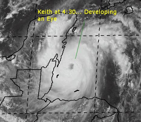
CFHC Talkback For News Story #124:
Newest Talkback: 10:47 AM 10-01 EDT

Keith Strengthens
04:46 PM EDT - 30 September 2000

Hurricane Keith has developed an Eye and is looking very impressive on the satellite. It has strengthened to a category 2 hurricane with 100MPH winds. It is projected to clip the NE tip of the Yucatan moving North Northwest as a Category 3 storm.

Keith's movement is still almost non-existant. Belize still has Hurricane Warnings up, and the Yucatan as well. Trends still suggest that it will wind up in the Gulf and eventually affect land between Lousiana and the Western coast of Florida. Keith has the potential to be one of the few "event" storms, so all eyes need to be on it anywhere in the Northwest Caribbean and Gulf. To be painfully redundant, it still isn't moving and until a trend is spotted it is all speculation. This may take a few days, so we'll be watching it very very closely.

Joyce is still a very weak tropical storm and may have trouble surviving into the Caribbean. Its weakened state has allowed it to slide westward and into the Caribbean. I'm not sure it will ever restregthen, but it will need to be watched. Isaac's nearing the end of its life as a tropical system, and will soon be an extratropical one.

More thoughts to come on this as time goes by...

Keith in the afternoon!

Comments or Questions? Everyone is invited to use it. Use the comment button by the story Headline.


NRL Monterey Marine Meteorology Division Forecast Track of Active Systems (Good Forecast Track Graphic and Satellite Photos)
Map with nearly all model projected tracks plotted for Isaac., Joyce, or Keith From Michael Bryson.
Crown Weather Services Tropical Update (Includes Map with multiple forecast model tracks)
Snonut's Hurricane Reports
Other commentary at: Mike Anderson's East Coast Tropical Weather Center - Stormwarn2000 - SCOTTSVB's Hurricane Update Center - Jim Williams' Hurricane City - Gary Gray's Millennium Weather - Even More on our Links Page
Satellite images at: [Visible] (visible -- Daytime Only) [Infrared] (infrared), and [Water Vapor] (water vapor)
Loops: Visible Loop - Infrared Loop - Water Vapor Loop
NASA GHCC Interactive Satellite images at:
[NAtl visible] (visible -- Daytime Only) [NAtl infrared] (infrared), and [NAtl water vapor] (water vapor)--Nasa source.
Defiant Visible Infrared More...
Ocean Surface Winds Derived from the SeaWinds Scatterometer (Experimental)
StormCarib.com has reports from folks in the Caribbean islands themselves and is worth checking out when storms approach the Caribbean.
Ouragans.com Français -- L'information sur des ouragans comprenant beaucoup de liens.
Tormenta.net Español -- Gran información sobre huracanes aquí.
Live Webcam image from Florida Emergency Management's Emergency Operations Center
Florida Emergency Management Activation Page / Situation Updates

Some Forecast models: (NGM, AVN, MRF, ECMWF, ETA)
DoD weather models (NOGAPS, AVN, MRF)
AVN, ECMWF, GFDL, NOGAPS, UKMET

- [mac]


Show All Comments | Show Previous 1 Comment

Displaying Talkbacks #2 - #2 (of 22 total)

Notes (#2)
Posted by:
Mike C. (http://flhurricane.com) Location: Newport News, VA (Currently)
Posted On 05:24PM 30-Sep-2000 with id (RTNRNUSNVY*)


I went ahead and added New Orleans and Mobile back into the popup lists. It gets big, I know, but it's good to get discussions from different points of view on the storm. Worst case is New Orleans, I think- but if it does affect the US Gulf coast, I tend to think a bit east. Still too much speculation involved.

intensity check (#3)
Posted by: HankFrank Location: Tallahassee
Posted On 05:36PM 30-Sep-2000 with id (QRXNQXVNQRSNSW*)


okay, cat 2 now. the pressure has fallen 15 mb in about as many hours.. interpolate that out and by noon tomorrow keith is a solid category three (though i dont think it will keep intensifying that fast). if keith comes up faster.. lets not even think of that happening. this isnt a mitch, its more compact, but the sluggish movement is just as troublesome. no movement for 12h? keith will have to begin moving after that or upwelling will start taking the storm back down. the nhc is leaning on the gfdl, it seems. just from looking at the intensity forecast from gfdl, id rather it not verify. it doesnt hack much strength off of keith over the northeast yucatan, neither does the nhc official. we dont need an already powerful hurricane in the lower gulf, moving slowly northward over 28-29C waters. come on keith, do the roxanne and leave us alone.
take it easy folks, be wary gulf coast.


Show All Comments | Show Next 1 Comment | Show Previous 1 Comment


Return to Central Florida Hurricane Center Main Page