CFHC Talkback For News Story #46:
Newest Talkback: 07:54 AM 06-26 EDT

Nothing going on.
09:30 AM EDT - 23 June 2001

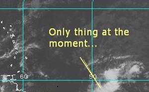
Only have one slight bit of action going on nearing the Caribbean, but like most systems this time of year it isn't all that likley do that much. It is worth noting hower because of some of the characteristics that it is showing. The system close to 50W, will be the only thing going on for the next few days.

On my scale for development potential:

(forget it) 0 1 2 3 4 5 6 7 8 9 10 (sure thing)
           [----*-----------------]
June???


We had some network connection problems earlier in the week that have now been resolved, the site should be much faster than it has been.


NASA GHCC Interactive Satellite images at:
[NAtl visible] (visible -- Daytime Only) [NAtl infrared] (infrared), and [NAtl water vapor] (water vapor)--Nasa source.
Defiant Visible Infrared More...
Some Forecast models: (NGM, AVN, MRF, ECMWF, ETA)
DoD weather models (NOGAPS, AVN, MRF)
AVN, ECMWF, GFDL, NOGAPS, UKMET

- [mac]


Show All Comments

Displaying Talkbacks #1 - #12 (of 12 total)

The wave (#1)
Posted by: Alex K
Posted On 11:08AM 23-Jun-2001 with id (VSNTRNQTTNYV*)


The wave east of the Caribbean at about 10 north is looking a bit more organizid on satalite this morning. There even appears that there may be a weak circulation associated with the northern convection. All in all, I'll give it a 10-20% chance of becoming a depression, but once it reaches the Caribbean, it appears shear is high.

Wave (#2)
Posted by: Steve H.
Posted On 01:10PM 23-Jun-2001 with id (QURNQVSNRPQNTX*)


Latest sat image/loop I have (16:15) shows a pretty concentric system taking shape, with some outflow exhaust. I'd change that 2 to a 6 or 7. Let's see what the next 12 hours show. Cheers!!

Wave (#3)
Posted by:
Colleen Location: Lakeland
Posted On 02:04PM 23-Jun-2001 with id (QURNQVSNQYTNRQS*)


I agree Steve...I just looked at the IR and WV loops; it's definitely looking healthier at this time. The Visible loops are not as informative (that's not really the word I'm looking for, but you know what I mean) as the other two. The convection is increasing and there is some outflow. I wouldn't write this one off just yet.

Colleen :-)

persistence (#4)
Posted by: HankFrank Location: Aiken, SC
Posted On 04:48PM 23-Jun-2001 with id (RPTNQQVNQVNQPW*)


i didnt really expect that wave to still be there by now, but it is. doesnt look better than it did 12h ago, but it has another 36-48hrs before it runs into the hurricane graveyard in the SE caribbean. a closed low developing on this wave would probably mean depression status, so it has an ok chance. another 24hrs of steady convection would probably trigger that... so it might beat the law of averages. anyhow, id keep an eyeball on the bermuda triangle area into next week too, as the upper low in the eastern u.s. retrogrades and the bermuda high backs up to the north.

Wave and Triangle (#5)
Posted by: Steve H.
Posted On 08:23PM 23-Jun-2001 with id (VTNQRNQPVNSS*)


Wave seems to be losing it's convection now, so we'll await and see if it folds or maintains/refires. Needs to be a few degrees further north, but we'll see. The convection off the east coast down through the Caicos looks interesting. Something may get churning in the next few days. Cheers!!

it gone (#6)
Posted by: HankFrank Location: Aiken, SC
Posted On 12:17AM 24-Jun-2001 with id (RPTNQQVNQVNYV*)


so much for persistence. as of midnight nothing looks potent. theres an eastpac system fixing to fire, though. cosme if it gets together.

? none (#7)
Posted by: scottsvb (
http://communities.msn.com/HURRICANEUPDATECENTER) Location: tampa
Posted On 03:49AM 24-Jun-2001 with id (QRNWWNQSXNQQR*)


Nothing of intrest going on but hype.
Maybe in a few days.

the wave (#8)
Posted by: joe Location: tampa florida
Posted On 06:34AM 25-Jun-2001 with id (RTNRXNQSNTY*)


dont look like it is going to do anything at this timeits just a tickler for now

Wave is Persistent (#9)
Posted by: Steve H.
Posted On 09:56AM 25-Jun-2001 with id (QSRNRRXNWPNQX*)


Wave still alive in the eastern Caribbean, and is looking formidable again. With high pressure expected to build in the western atantic during the week, things could get interesting. I still think development of this area is quite possible. Cheers!!

Eastern Caribbean Wave (#10)
Posted by: Joe Location: St.Petersburg, FL
Posted On 03:17PM 25-Jun-2001 with id (VTNRTTNQNQTV*)


It's not to organizid but like Steve said when the high builds into the western atlantic over the next couple of day's things may become intresting. If any thing they'll boost are rain chances up here in Central and Southern Florida my late week.

shear (#11)
Posted by: HankFrank Location: Aiken, SC
Posted On 12:33AM 26-Jun-2001 with id (RPTNQQVNQVNQQQ*)


either theres a lot more convection getting torn up to make it apparent, or there wasnt as much shear in the basin a few days ago. quite nasty almost everywhere. until this cools off some nothing has a chance. looks like the TUTT is settling in, with shear across the caribbean and the upper low east of bermuda. everything at low latitudes is fairly well screwed. if anything goes in the near future it'll be the mid-latitude conversion type storm.

Shear (#12)
Posted by: Steve H.
Posted On 07:54AM 26-Jun-2001 with id (QSRNRRXNWPNQX*)


Right on Hank, the shear is definitely tearing the crap out of these waves. Good call Mike C. on the disturbance, it did not develop as I thought. I jumped the gun. Here's where I qualify it though. As Hank said a mid-level conversion storm would be the only way, and this may still happen as there seems to be a mid-level circulation from the wave racing to the west SE of Jamaica, and the northern branch of the wave that passed the Turks earlier. As high pressure builds (and I think it will by tomorrow)in the western Atlantic. The shear bear should settle down and at least give these waves the opportunity to develop. Early pix show convection both NE and SW of Cuba. Again its a waiting game, and timing is everything, as this wave may be way gone before conditions become favorable again. There are other interesting waves in the Atlantic as well, but too far out to even discuss at this point. We'll see if the ridge develops across the Carolinas out into the Atlantic first. If this doesn't occur, the discussion moot, as it may be anyhow. Cheers!!


Show All Comments


Return to Central Florida Hurricane Center Main Page