CFHC Talkback For News Story #53:
Newest Talkback: 09:43 PM 07-28 EDT

Next Week may be Interesting
08:45 AM EDT - 11 July 2001

Space Shuttle Atlantis on mission STS-104 s a launch for the International Space Station scheduled tomorrow, the first with the new Block II style engines. Weather could be a factor today and tomorrow, so it could be pushed back until Friday, July 13. Along with the new engines the Moroccan emergency landing site will be nonfunctional too (due to threats). I for one hope the weather and rain holds off enough for it to get off tomorrow fine.

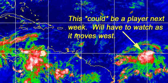
It's still blasé this week as far as storms, but it doesn't mean there is nothing to watch out for. I give you the wave near 40 degrees west...

Wave Mongers, awaken!
Ok, so what does this mean? Well not much in the immediate future, however, when you couple it with dropping fronts as this may approach Florida sometime next week, then you will have to watch. If this thing does anything it won't be any time soon. (However I could be surprised) It will be the thing to watch the next few days and over the weekend and especially into next week for us here. The Caribbean should be on the watch too in case the environment does become more favorable for development.

If it does develop I don't expect it to be soon (can't rule that out, though), and it's more likely that it won't, but here's the scale anyway.
(forget it) 0 1 2 3 4 5 6 7 8 9 10 (sure thing)
           [---------*------------]

The MRF is the one that does the most with it, but still its a little far off to speculate. I do think it will need to be watched.

The tell tale sign though is to watch for persistence of the thunderstorm activity in the wave.

Michael Bryson (creator of the Stormtrakker Hurricane Tracking Software, and who runs a pretty good site for original graphics) has moved his webpage and is now at
http://personal.bellsouth.net/mia/j/_/j_bryson/ He also has a new piece of software up called Nexrad3 which is a small Windows app that lets you quickly visibly review radar data from any NWS office.

Caribbean Hurricane Page - Updates from the various Caribbean Islands.

NRL Monterey Marine Meteorology Division Forecast Track of Active Systems (Good Forecast Track Graphic and Satellite Photos)

NASA GHCC Interactive Satellite images at:
[NAtl visible] (visible -- Daytime Only) [NAtl infrared] (infrared), and [NAtl water vapor] (water vapor)--Nasa source.
Defiant Visible Infrared More...
Other commentary at: Mike Anderson's East Coast Tropical Weather Center - Accuweather's Joe Bastardi - SCOTTSVB's Hurricane Update Center - Jim Williams' Hurricane City - Gary Gray's Millennium Weather - Even More on our Links Page

Some Forecast models: (NGM, AVN, MRF, ECMWF, ETA)
DoD weather models (NOGAPS, AVN, MRF)
AVN, ECMWF, GFDL, NOGAPS, UKMET

- [mac]


Show All Comments

Displaying Talkbacks #1 - #1 (of 43 total)

NRL (#1)
Posted by: NICK Location: ORLANDO FL
Posted On 11:03AM 11-Jul-2001 with id (RPUNQXXNQYYNRY*)


well the navy is in on it , just went up on there site as an invest/ the watching begins

Tropical Development (#2)
Posted by:
Mark Ruck Location: Cape Coral Florida
Posted On 11:33AM 11-Jul-2001 with id (QRNWWNQSRNQYR*)


TROPICAL WAVE PREVIOUSLY ALONG 38W/39W NOW ALONG 39W S OF 14N
MOVING W 10-15 KT. 1012 MB LOW PRESSURE CENTER ALONG WAVE NEAR
9N39W. THIS LOW PRESSURE CENTER IS IN AN ENVIRONMENT FAVORABLE
FOR TROPICAL DEVELOPMENT AND WILL BE MONITORED CLOSELY BY
NATIONAL HURRICANE CENTER DURING NEXT SEVERAL DAYS. SCATTERED
MODERATE/STRONG CONVECTION FROM 8N TO 10N BETWEEN 39W AND 43W

Well here we go. Upper air forcasts look favorable over the next 3-4 days and thunderstorms have increased some over night so we may have the beginings of our next system. Most models don't pick up this system but the MRF is showing some sign of development over the next few days. Conditions look favorable and with a weak low pressure evident all we can do is wait to see what happens. Its just in time to make my vacation interesting next week in the Bahama's!!


Show All Comments | Show Next 1 Comment


Return to Central Florida Hurricane Center Main Page