CFHC Talkback For News Story #53:
Newest Talkback: 09:43 PM 07-28 EDT

Next Week may be Interesting
08:45 AM EDT - 11 July 2001

Space Shuttle Atlantis on mission STS-104 s a launch for the International Space Station scheduled tomorrow, the first with the new Block II style engines. Weather could be a factor today and tomorrow, so it could be pushed back until Friday, July 13. Along with the new engines the Moroccan emergency landing site will be nonfunctional too (due to threats). I for one hope the weather and rain holds off enough for it to get off tomorrow fine.

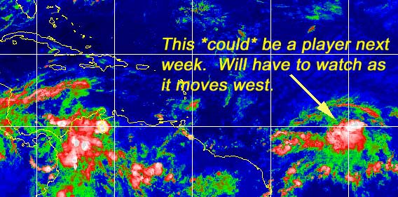
It's still blasé this week as far as storms, but it doesn't mean there is nothing to watch out for. I give you the wave near 40 degrees west...

Wave Mongers, awaken!
Ok, so what does this mean? Well not much in the immediate future, however, when you couple it with dropping fronts as this may approach Florida sometime next week, then you will have to watch. If this thing does anything it won't be any time soon. (However I could be surprised) It will be the thing to watch the next few days and over the weekend and especially into next week for us here. The Caribbean should be on the watch too in case the environment does become more favorable for development.

If it does develop I don't expect it to be soon (can't rule that out, though), and it's more likely that it won't, but here's the scale anyway.
(forget it) 0 1 2 3 4 5 6 7 8 9 10 (sure thing)
           [---------*------------]

The MRF is the one that does the most with it, but still its a little far off to speculate. I do think it will need to be watched.

The tell tale sign though is to watch for persistence of the thunderstorm activity in the wave.

Michael Bryson (creator of the Stormtrakker Hurricane Tracking Software, and who runs a pretty good site for original graphics) has moved his webpage and is now at
http://personal.bellsouth.net/mia/j/_/j_bryson/ He also has a new piece of software up called Nexrad3 which is a small Windows app that lets you quickly visibly review radar data from any NWS office.

Caribbean Hurricane Page - Updates from the various Caribbean Islands.

NRL Monterey Marine Meteorology Division Forecast Track of Active Systems (Good Forecast Track Graphic and Satellite Photos)

NASA GHCC Interactive Satellite images at:
[NAtl visible] (visible -- Daytime Only) [NAtl infrared] (infrared), and [NAtl water vapor] (water vapor)--Nasa source.
Defiant Visible Infrared More...
Other commentary at: Mike Anderson's East Coast Tropical Weather Center - Accuweather's Joe Bastardi - SCOTTSVB's Hurricane Update Center - Jim Williams' Hurricane City - Gary Gray's Millennium Weather - Even More on our Links Page

Some Forecast models: (NGM, AVN, MRF, ECMWF, ETA)
DoD weather models (NOGAPS, AVN, MRF)
AVN, ECMWF, GFDL, NOGAPS, UKMET

- [mac]


Show All Comments | Show Previous 39 Comments

Displaying Talkbacks #23 - #43 (of 43 total)

You're Welcome! (#23)
Posted by:
Colleen Location: Lakeland, FL
Posted On 08:58PM 11-Jul-2001 with id (RPUNQXXNRPPNQXQ*)


No problem ...actually, it helped me, too. He's very good at explaining things so I understand them.

Colleen :-)

convection (#24)
Posted by: Alex K
Posted On 09:12PM 11-Jul-2001 with id (VSNRSRNQQQNRSV*)


Look at the latest colorized infared for the low. Convection seems to be currently waxing. I'll say it has a 35-40% chance to be upgraded at 11, and a 60-70% chance by tommorrow, if the convection persists. Also, thank you Colleen;you are always very helpful.

Convection & Something Else (#25)
Posted by:
Colleen Location: Lakeland, FL
Posted On 09:16PM 11-Jul-2001 with id (RPUNQXXNRPPNQXQ*)


Actually, Alex..I thought (and I could be wrong) that the convection we're seeing now is more impressive than what we saw in the last loop. The last loops showed mostly blues? and this latest loop is showing more yellow/orange. If this continues overnight, we may have TD#2 by tomorrow. (although I could be wrong, the last time I looked before now was about 6:30 or 7.)

One other thing I saw out there: the wave that just came off the coast of Africa looks very nice...(well, as nice as waves can look, if you get my drift). It's lower in latitudes than the other system....but is there any chance for development of this new one, and if it did develop, would it hinder the other storm?

Colleen :-)

Next System on the way (#26)
Posted by: Joe Location: St.Petersburg, FL
Posted On 09:21PM 11-Jul-2001 with id (RQVNSNQXRNUU*)


Well after looking at the infrared satellite. Convection looks real nice inflow and ouflow look good, also shear is fairly light near and around the system. I'am thinking update at 11 PM will bring our second system this year, but they may hold off till 5 AM to see if convection holds its own as mentioned ubove in earlier posts

I'm not angry-just wanted to point out something (#27)
Posted by: Alex K
Posted On 09:38PM 11-Jul-2001 with id (VSNRSRNQQQNRSV*)


Colleen, sorry if you interpreted me incorrectly, I might have not made myself clear enough when I said the convection was increasing. That was what I was trying to say.

:)

Agree Alex (#28)
Posted by: Joe Location: St.Petersburg, FL
Posted On 09:40PM 11-Jul-2001 with id (RQVNSNQXRNUU*)


Convection has decreased in intensity just a bit has there was more in the way of reds earlier. Never the less fairly well organized. Colleen the system off africa is looking fairly intense but I'am not to confident it will develope do to the system ahead of, but I could be wrong. Needs to pull a bit further north like the system ahead of it did.

TD#2? (#29)
Posted by:
Mark Location: Cape Coral Florida
Posted On 09:44PM 11-Jul-2001 with id (QRNWWNQWWNRU*)


Pressure measured down to 1010mb and dropping. I see thunderstorms redeveloping near the center. Upper air favorable and will become more favorable as it approaches the islands with a southerly flow which should increase outflow and allow for development to continue. Folks in my opinion we have one....VERY SOON!!

organizing (#30)
Posted by:
Keith Location: orlando
Posted On 09:47PM 11-Jul-2001 with id (RPUNQXXNQYRNQUT*)


On the last loops, the system appeared to be flaring up just a little after waning. There also appeared to be a bit of tightening. What does everybody think?

Thanks
Keith

Wave (#31)
Posted by:
Mike C. (http://flhurricane.com) Location: New Smyrna Beach, FL
Posted On 09:47PM 11-Jul-2001 with id (RPYNQUVNRTPNQY*)


Yep, I think my chances for development tonight are around 60%, and tomorrow morning around 75%.

Pretty good odds for this system. Actually I think it'll have a harder time in the long run if it develops now than if it waited a bit.


Your right Keith (#32)
Posted by: Joe Location: St.Petersburg, FL
Posted On 10:04PM 11-Jul-2001 with id (RQVNSNQXRNUU*)


After looking at the latest satellite, the system is flaring up again and like you said it is tightening. I guess I spoke just a bit soon should have waited for new satellite image. Still think theres a 60% or so chance of this developing at 11 PM. We shall see...

Update (#33)
Posted by:
Rick D. (http://flhurricane.com/rad/) Location: St. Petersburg FL .
Posted On 10:06PM 11-Jul-2001 with id (VUNSTNXYNRPQ*)


Hey Mike , I see another update coming? Looks as if it is developing into something

Classification? (#34)
Posted by: Alex K
Posted On 10:37PM 11-Jul-2001 with id (VSNRSRNQQQNRSV*)


Has the low been classified as a depression? Thanks

depression or storm (#35)
Posted by:
Keith Location: orlando
Posted On 10:39PM 11-Jul-2001 with id (RPUNQXXNRPPNSQ*)


I am far from an expert but my guess is that this is at least a depression right now if not a minimal storm. It has a disernable rotation to it already and convection continues to flare in the p.m. hours. We'll see! How does that saying go, "if it walks like a duck....."

It has been classified (#36)
Posted by: Alex K
Posted On 10:43PM 11-Jul-2001 with id (VSNRSRNQQQNRSV*)


I guess the answer to my question is yes.

TD #2 (#37)
Posted by:
Rick D. (http://flhurricane.com/rad/) Location: St. Petersburg FL .
Posted On 10:45PM 11-Jul-2001 with id (VUNSTNXYNRPQ*)


#2 is here

TD Number 2 (#38)
Posted by: Joe Location: St.Petersburg, FL
Posted On 10:49PM 11-Jul-2001 with id (RQVNSNQXRNUU*)


We got a TD.


TD Number 2 (#39)
Posted by: Joe Location: St.Petersburg, FL
Posted On 10:49PM 11-Jul-2001 with id (RQVNSNQXRNUU*)


We got a TD.


TD2 (#40)
Posted by:
John C. (http://flhurricane.com) Location: Cocoa
Posted On 10:53PM 11-Jul-2001 with id (VUNSSNQWNYW*)


Yep, TD 2 is here, Mike is writing a new artical as I type this. Stand by:

The Discussion (#41)
Posted by: Joe Location: St.Petersburg, FL
Posted On 11:01PM 11-Jul-2001 with id (RQVNSNQXRNUU*)


NHC is saying that it will go into tropical storm formaion tomorrow which I can see for sure. Then they go onto say it will be effected by the upper low in a few days. I think thats a bit early to say if it will effect it or not. Never the less TD#2 has formed.

Alex...You're Right (#42)
Posted by:
Colleen Location: Lakeland, FL
Posted On 11:37PM 11-Jul-2001 with id (QURNQVSNRQSNUQ*)


I did misinterpret your post...I saw "waning" not "waxing"....duh! Sorry! ;-)

test (#43)
Posted by:
Mike C. (http://flhurricane.com) Location: Cocoa
Posted On 05:43PM 28-Jul-2001 with id (VUNSSNQWNYW*)


test


Show All Comments | Show Previous 39 Comments


Return to Central Florida Hurricane Center Main Page