CFHC Talkback For News Story #57:
Newest Talkback: 04:49 AM 07-20 EDT

A Lot of "Maybe"
02:43 PM EDT - 16 July 2001

What we have this week is a lot of maybe something, nothing definite, and nothing immediate. However it's nearing the latter half of July, so we normally want to start looking around more, although we are still one month away fromt the start of the peak season.

Right now take a look...

Wave Mongers, awaken!

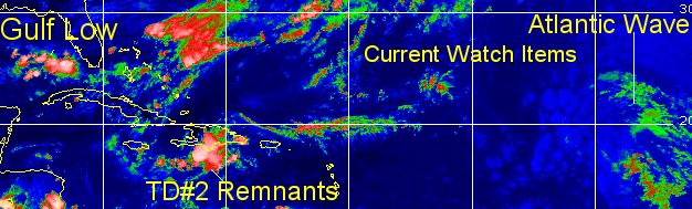
What do we have here. Well the low in the Gulf with a system that I mentioned last week forming off the front that came down.

Let me state my thoughts on that one by using the potential for development graph:

(forget it) 0 1 2 3 4 5 6 7 8 9 10 (sure thing)
           [-*--------------------]

Just remember our luck with Gulf systems so far, but I'm fairly certain that one is a bust.

Still Nope. It's not gonna happen... so lets look elsewhere...

TD#2's remnants are showing some signs of life south of Hispaniola, and if it were to make it north of the islands somehow, the spark with the front remnants would cause something. However...

(forget it) 0 1 2 3 4 5 6 7 8 9 10 (sure thing)
           [--*-------------------]

That's not going to happen, and the Caribbean is hostile for development until it reaches the extreme western portion. I don't expect anything there either.

The last wave, in the Atlantic has a lot of amplitude, but no signs of development. Ie no core storms around what would be the center. If this were August, we'd be singing a different tune on it. But it could move into an area more favorible for development EXCEPT for the water temps.
(forget it) 0 1 2 3 4 5 6 7 8 9 10 (sure thing)
           [---*------------------]


Just not much going on, with a lot of maybe's. The front stalling out didn't do anything, and TD#2 remnants are doomed in several ways. We'll keep watching though, since we've been surprised before. But nothing will happen today or tomorrow in my opinion.

NRL Monterey Marine Meteorology Division Forecast Track of Active Systems (Good Forecast Track Graphic and Satellite Photos)

NASA GHCC Interactive Satellite images at:
[NAtl visible] (visible -- Daytime Only) [NAtl infrared] (infrared), and [NAtl water vapor] (water vapor)--Nasa source.
Defiant Visible Infrared More...
Other commentary at: Mike Anderson's East Coast Tropical Weather Center - Accuweather's Joe Bastardi - SCOTTSVB's Hurricane Update Center - Jim Williams' Hurricane City - Gary Gray's Millennium Weather - Even More on our Links Page

Some Forecast models: (NGM, AVN, MRF, ECMWF, ETA)
DoD weather models (NOGAPS, AVN, MRF)
AVN, ECMWF, GFDL, NOGAPS, UKMET

- [mac]


Show All Comments

Displaying Talkbacks #1 - #20 (of 20 total)

Possible Circulation? (#1)
Posted by:
Rich Byett (http://www.stormwarn2000.com) Location: Gloucester, England, UK
Posted On 10:41AM 17-Jul-2001 with id (RQSNQRRNUXNQYU*)


Looking at the latest visible imagery (1km, 14:01 UTC, 17th July) i think i see a circulation near 18.4N 80.1W east of Jamaica and south of the Caymans. This is associated with the wave that is the remnants of TD2. There appears to be currently just two very small pockets of convection, one to the north of the centre, and one to the ease/southeast of the centre. Might be interesting to see if this area fires up again during today.

Rich

high amp wave (#2)
Posted by: HankFrank Location: Aiken, SC
Posted On 06:47PM 17-Jul-2001 with id (RPTNQQVNQVNQQR*)


watch the wave near 50w to see if it starts firing as it nears the islands. on vapor a mid level circulation is passing near 16n 52w, heading wnw.. it is choked by subsidence currently, but a good convective flareup might bring it to life at the surface. the upper low moving in tandem to the west might provide the spark. might is right. everything is a weak maybe.. the dying front in the southeast has been sheared over, none of the little whirls has had any convective support. might be eating crow over all of this inactivity.

Wave (#3)
Posted by: Steve H.
Posted On 09:53PM 17-Jul-2001 with id (RPUNQXXNQYWNSQ*)


The wave you mentioned HankFrank is quite impressive. If the trough pulls out on lessens its negative effect (strong SW shear) than the wave could indeed develop a tropical system...need to watch it durign the next few days. Other than that, we'll have to look near Africa for any possible development. Strong convection is firing below 10N at about 20W. Another strong impulse looks like it will come off the coast in 6-10 hours. Yes its early for that area, but the ITCZ has pulled northward in that area and conditions are favorable at least at upper levels for some development during the next few days. From the islands west, the environment is hostile. We're getting closer to spawning time now. Cheers!!

high amp 2 (#4)
Posted by: HankFrank Location: Aiken, SC
Posted On 03:22AM 18-Jul-2001 with id (RPTNQQVNQVNQQQ*)


the big wave nearing the islands is finally starting to break free of the subsidence that has been plaguing it for most of its existence. its mid level core on wv is around 18/56, heading wnw.. it should pass just north of the upper low around puerto rico, which is part of a long trough axis. when the wave crosses this area, some section will flare up, probably the part that crosses the diffluent flow around the north edge of the upper low. several of the models continue tracking this wave towards the bahamas, and then sort of mix it in with the next frontal system which should back into the southeast over the next weekend (yes, another). like the last front, another large area that could support development is in the works, provided that the westerlies dont descend to slash everything to ribbons again. the long range avn and nogaps and even ngm are placing lows around the southeast over the weekend, should provide us with something to look for at least. this time of year it's all wave mongering.

Watch the Wave (#5)
Posted by: Steve H.
Posted On 07:31AM 18-Jul-2001 with id (QSRNRRXNWPNQX*)


The Strong wave approaching the islands around 18N is developing a circulation. Watch out for this one folks. It seems to be gathering convection rather quickly. Any other thoughts on this one? The IR loop looks impressive this morning/no vis loop available yet. Also, watch the eastern Atlantic. Back to work. Cheers!!

SWIRL (#6)
Posted by: NICK Location: ORLANDO FL
Posted On 09:26AM 18-Jul-2001 with id (QURNQVSNRQSNRQR*)


I agree steve , in satelite loops it looks pretty
impressive and it looks like storms are slowly starting to fire up around that circulation, anybody know if this system has a chance or not


Swirl? (#7)
Posted by:
gary Location: jacksonville
Posted On 10:00AM 18-Jul-2001 with id (RPUNQURNVUNR*)


It looks on the water vapor like it could be something. Could be fun to watch...

what about caribbean? (#8)
Posted by:
shawn samuels Location: houston,tx
Posted On 11:24AM 18-Jul-2001 with id (RPWNRQXNRSUNRS*)


is there some sort of swirl in the extreme northwest caribbean? not much storm activity with it but as it moves into the gulf things could change.i believe high pressure aloft is centered in the gulf.does anyone else believe we might see something down the road here?

AVN & MRF 4-6 Day Models (#9)
Posted by: Steve Location: Old Metairie, LA
Posted On 02:49PM 18-Jul-2001 with id (RPXNRTXNRSQNUX*)


These two models show a low just south of the LA Coast between 1009mb and 1011mb starting on Day #4. Because these lows don't appear to be coming from anywhere in particular, does anyone have any ideas? I'm thinking the low may be a result of former TD #2 or possibly the cluster currently south of the keys, but none of that is moving all that deliberately westward.

Steve

Circulation (#10)
Posted by:
Dave
Posted On 03:55PM 18-Jul-2001 with id (QRNTQNYQNRST*)


Hello,

Just a quick question.
It looks like there is some real circulation going on at 64/18 (ish). You can see it with this link: http://sgihss3f.wwb.noaa.gov/data4/images/TROPICAL/float/float-ir4-loop.html

Does this have any "real" potential?

SATELLITE LOOP (#11)
Posted by:
LONNY Location: HOLLYWOOD,FL
Posted On 05:08PM 18-Jul-2001 with id (RPUNQXXNQYRNUY*)


I saw the IR sat.loop. I think it is a upper or mid level low. If you look at it on the water vapor loop it looks more like a mid-level low. Who knows maybe it will make it to a surface low. The NHC has said nothing on the "outlooks" try reading their "discussion".

Boring!!! (#12)
Posted by:
shawn samuels Location: houston,tx
Posted On 05:43PM 18-Jul-2001 with id (RPWNRQXNRPVNQYV*)


Is it dead out there or what? I thought there might be some hope for the cluster of storms around the Florida Keys but that is even losing its punch.The remains of TD#2 seem to be gone and I see nothing else in the works for a great while.If someone can see any glimmer of hope for some excitement out in the tropics,please post where you think it may happen.

August is coming (#13)
Posted by:
Rick D. (http://flhurricane.com/rad/) Location: St. Petersburg FL .
Posted On 08:31PM 18-Jul-2001 with id (VUNSTNXYNY*)


Wont be long now !!

or not (#14)
Posted by: HankFrank Location: Aiken, SC
Posted On 01:18AM 19-Jul-2001 with id (RPTNQQVNQVNWQ*)


there hasnt been anything overwhelming from that wave. the way things look tonight, there wont be anything tomorrow. sorry shawn, no glimmer here. if you want action, watch your home team.. the astros put on a good show tonight. oh yah, steve.. the td 2 remnant wave became low amplitude and crossed south america.. it is crossing central america this evening, heading into the pacific. so maybe td 2 will be reborn as.. whatever the eastpac D name is. that stuff in the gulf is probably related to whatever the big upper high brings down from the continent.. not of tropical origin. if you extrapolate the wave around 63w it does end up in the area in a few days, so maybe it's part of the equation too.
anyhow, you folks know a good recipe for crow? over the weekend i predicted that we'd get something within a week.. its thursday and nothing is on the horizon.


sleep time? (#15)
Posted by: shawn samuels Location: houston,tx
Posted On 12:28PM 19-Jul-2001 with id (RPWNRQXNRSVNQVY*)


Can someone wake me up when there is even any clouds to discuss in the Atlantic Basin.It's been a long time since I have seen it so absent of clouds trough the basin during hurricane season.Correct me if I'm wrong but didn't Dr. Gray's forecast call for above activity during the first half of the season?I guess he can even be wrong sometimes.Please,anyone,give us some action.By the way,way to go Bagwell and the rest of the Astros.

ZZZZ... (#16)
Posted by: Doug Location: Tallahassee
Posted On 03:34PM 19-Jul-2001 with id (RPXNQWPNWXNTY*)


dum...de...dum...dum...

Ive Never Been so Bored (#17)
Posted by: Robert
Posted On 09:44PM 19-Jul-2001 with id (RTNTXNQUQNV*)


I hate the end of july, school has been out for months its to hot to go out side,and there is no waves to surf on ,theres no hurricanes to make waves.it rains all afternoon anyways so you just sit there totaly dazed waiting for something to happen.

Bored? (#18)
Posted by: Ross Location: Fort Lauderdale
Posted On 10:34PM 19-Jul-2001 with id (VVNSRNTQNYV*)


Um, last I checked, no hurricanes was a *good* thing. If that's boring, I'll take it. Keeps my insurance down, anyway....

yes i am bored (#19)
Posted by: Robert
Posted On 11:32PM 19-Jul-2001 with id (RTNTXNQUQNV*)


i am very bored the hurricanes are gonna come anyways i might as well have some funn when they come. have you ever scene the swels made by the fish systems way far out, the swells are huge for florida

the late report (#20)
Posted by: HankFrank Location: Aiken, SC
Posted On 12:49AM 20-Jul-2001 with id (RPTNQQVNQVNXX*)


well, theres actually something to look at tonight. southeast of bermuda, heading north in the mid atlantic... say 29n60w. a mid level circulation, possibly low level, has spun up in the middle of that weakened upper trough, along the remains of that wave axis ive been watching for days. if the convection doesnt puke out overnight, first light visible in a few hours should tell us if something is forming. i can still see the part of the wave i was paying the most attention to as well.. it's moving in tandem with the well cut upper low to its southwest over hispaniola.. i'd say the spot i'm tracking is 21/65, moving wnw. should it hit the upper lull that it's companion to the north did, it might try something as well. turned out to be useless speculation last time, but another front is headed for florida in and the NE gulf. the latest models say a low will be around the big bend by sunday.. as with last weekend, something to watch. right. woo hoo.


Show All Comments


Return to Central Florida Hurricane Center Main Page