CFHC Talkback For News Story #70:
Newest Talkback: 04:55 AM 08-24 EDT

Debby Weakens Temporarily
11:08 AM EDT - 23 August 2000

5PM Update:

The NHC lowered windspeed to 50MPH, but Debby is still not looking good at all. If it goes into Cuba I doubt it can survive. The other choices are going north or south of Cuba, and that's about a 50/50 shot for either. Debby did the unexpected, will the unexpected happen again?

1PM Update:

Mandatory Evacuation Ordered for all non-Florida Keys residents in the Florida Keys effective at Noon Today

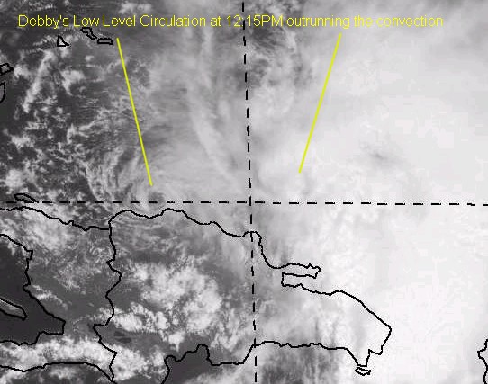
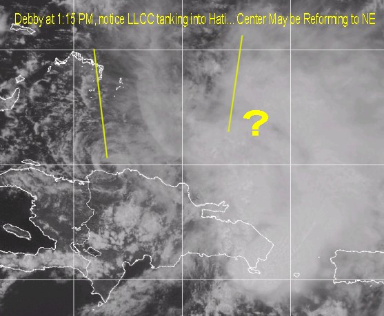
Debby is encountering more sheer and land effects, and isn't looking as good as it did before. The center of cirulation is on the west side of the convection, so it is having trouble again. Debby looks like it won't restrengthen until tomorrow. This is an unexpected twist in the story of Debby (or at least, I didn't expect this) and the storm may wind up repositioning itself to survive, if it survives. Thanks Steve H. & Brian for bringing this to our attention.

Alberto has become Extratropical as well and is no longer being tracked.

Debby's Low Level Circulation Center racing away
Debby's Low Level Circulation Center Diving into Hispaniola Reform possible?


Original Update:

Due to some interaction with Hispaniola and a bit of shear Debby went down to Tropical Storm this morning. A strong tropical storm. It should rebound later tonight and tomorrow when it moves away from Hispaniola and strengthen. The southern inflow is being affected by the mountains there.

The current NHC forecast track takes it up South Florida (over Key Largo) over Florida toward the core of the state to the western side with a hint of a northerly turn. This could be shifted left or right more later... So the Keys must take it seriously too.

There are some indications that Debby may slow forward motion too, so it looks Friday Night- Saturday timeframe for landfall at the moment.

Several Models put it into the Gulf, including the MRF, which means folks in the panhandle, Alabama, etc. will want to watch it too.

Still a lot of speculation. It still could go into the Gulf, but the South Florida scenario is still more likely. (Getting to be 50/50 chance wise). Still a lot up in the air.

We are tentively scheduling a chat at 7PM tonight lasting for as long as we feel the need. Jim Williams at
Hurricane City will be doing another live broadcast at 8PM.

Comments or Questions? Everyone is invited to use it. Use the comment button by the story Headline.

NRL Monterey Marine Meteorology Division Forecast Track of Debby (Good Forecast Track Graphic)

Ouragans.com Français -- L'information sur des ouragans comprenant beaucoup de liens.
Tormenta.net Español -- Gran información sobre huracanes aquí.

Crown Weather Services Tropical Update (Includes Map with multiple forecast model tracks)
Snonut's Hurricane Reports
Weathervine Storm Intercept Team's Audio and Video broadcasts
Live Webcam image from Florida Emergency Management's Emergency Operations Center
Florida Emergency Management Activation Page / Situation Updates
Nice Satellite Image of Atlantic (IR Colorized)

Satellite images at: [N.A. visible] (visible -- Daytime Only) [N.A. infrared] (infrared), and [N.A. water vapor] (water vapor)--Nasa source.

Some Forecast models: (NGM, AVN, MRF, ECMWF, ETA)
DoD weather models (NOGAPS, AVN, MRF)
AVN, ECMWF, GFDL, NOGAPS, UKMET

- [mac]


Show All Comments

Displaying Talkbacks #1 - #1 (of 64 total)

Core of the state? (#1)
Posted by:
alan Location: orlando
Posted On 11:13AM 23-Aug-2000 with id (RPVNRQUNRRQNRUR*)


Where do you see core of the state. The 72 hour prediction has it in Florida bay heading NW. It would have to turn due north to go up the core of the state.
Just wondering if I'm missing something.

50/50 (#2)
Posted by: Steve h.
Posted On 11:15AM 23-Aug-2000 with id (QSRNRRXNWPNQX*)


Mike C., do you still foresee a nw turn at some point ? I don't see strong evidence for that, but I haven't looked at data about the trough that is supposed to dig southward to ALA/GA. However if it slows and waits then reacts to the trough later, the east FL coast could see her miami northward. ANy thoughts on this? Is the FL east coast out of the woods?


Show All Comments | Show Next 1 Comment


Return to Central Florida Hurricane Center Main Page