 |
||
 |
||
Debby Weakens Temporarily
11:08 AM EDT - 23 August 2000
5PM Update:
The NHC lowered windspeed to 50MPH, but Debby is still not looking good at all. If it goes into Cuba I doubt it can survive. The other choices are going north or south of Cuba, and that's about a 50/50 shot for either. Debby did the unexpected, will the unexpected happen again?
1PM Update:
Mandatory Evacuation Ordered for all non-Florida Keys residents in the Florida Keys effective at Noon Today
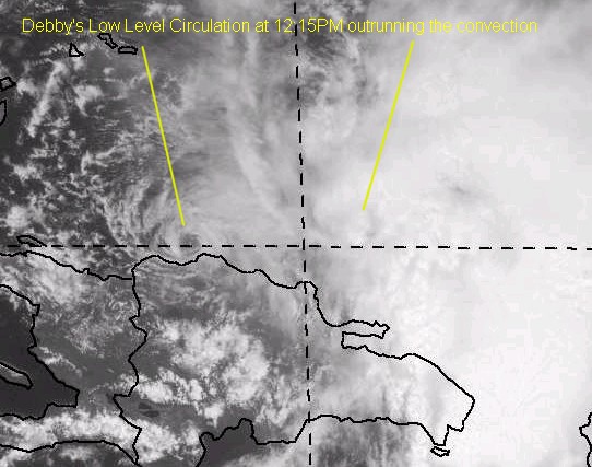
Debby is encountering more sheer and land effects, and isn't looking as good as it did before. The center of cirulation is on the west side of the convection, so it is having trouble again. Debby looks like it won't restrengthen until tomorrow. This is an unexpected twist in the story of Debby (or at least, I didn't expect this) and the storm may wind up repositioning itself to survive, if it survives. Thanks Steve H. & Brian for bringing this to our attention.
Alberto has become Extratropical as well and is no longer being tracked.
|
||
|
||
Comments or Questions? Everyone is invited to use it. Use the comment button by the story Headline.
NRL Monterey Marine Meteorology Division Forecast Track of Debby (Good Forecast Track Graphic)Satellite images at: [N.A. visible] (visible -- Daytime Only) [N.A. infrared] (infrared), and [N.A. water vapor] (water vapor)--Nasa source.
Some Forecast models: (NGM, AVN, MRF, ECMWF, ETA)- [mac]
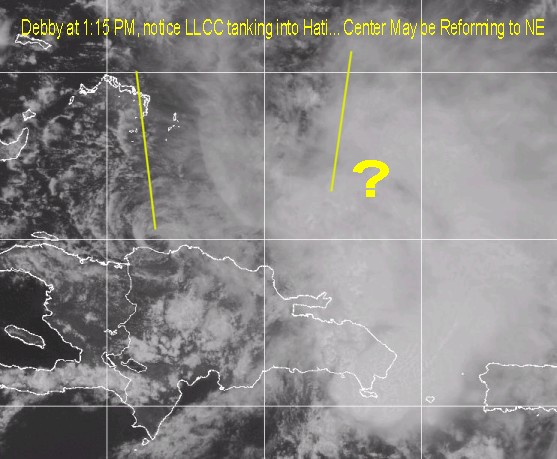
Mike-
I sure did notice that. Extremely interesting. I'm not exactly sure what to make of it except....it sure is not getting back to hurricane status very soon thats for sure.
I guess two possibilities exist....LL cloud swirl will continue west and develop more
convection over time...like 12-24 hours and become a "new" Debby....or the more likely scenario for a new center to re-form under the deep convection as you said.
Ramifications for Florida....If LL swirl takes over down the road it is going to be of little concern to Florida as it will head WEST into the gulf...by way of south of or over cuba...this is best case scenario for florida...and that LL Swirl will make good headway
being pushed by the LL steering.
On the other hand...if a new center forms under the deep convection we're back where we started only a day or so behind schedule...since the center will be clear of the islands and will head on a more w.n.w. track from a further north starting point.
Very interesting to say the least...I've not seen anything like this in a long time.
Gonna make for some interesting updates in the hours ahead!