CFHC Talkback For News Story #94:
Newest Talkback: 01:28 PM 09-15 EDT

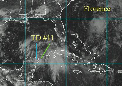
TD#11 Over Land or Not?
05:23 PM EDT - 14 September 2000

An interesting occurance is happening with Tropical Depression Eleven. Mainly the fact that its Low Level Circulation Center (LLCC) is over land, but the mid level circulation is over water. Since its a relatively weak depression, this brings out some interesting possibilities. Officially the low level center is over land, and surface observations verify this.
1. It could die out over night over land. This is possible, and from Debby earlier in the year it can be shown to happen. Not a likely solution, but possible none-the-less.
2. It could keep its circulation center and move back over land and eventually form into a tropical storm. (Slightly more likely).
3. Most interesting of all, it could reform its center under the much better defined mid-level circulation out over the water now and slowly work its way into the central Gulf. This possibility allows it to become a hurricane. And the official statement from the NHC has it somewhere between 2 and 3, and calls for a hurricane to form later on.

Therefore, tomorrow will be an interesting day to watch this system. Folks along the Gulf could see anything from a damp rainstorm, to hurricane force winds sometime next week. I'm tending to think this will be a slow mover, and taunt us for a while. Expect the unexpected with this system. Models are virtually no help at the moment because the center is questionable. The entire Gulf needs to watch it.

TD#11

Comments or Questions? Everyone is invited to use it. Use the comment button by the story Headline.

NRL Monterey Marine Meteorology Division Forecast Track of Active Systems (Good Forecast Track Graphic and Satellite Photos)

Map with nearly all model projected tracks plotted for TD#11. From Michael Bryson.

Crown Weather Services Tropical Update (Includes Map with multiple forecast model tracks)
Snonut's Hurricane Reports

Satellite images at: [N.A. visible] (visible -- Daytime Only) [N.A. infrared] (infrared), and [N.A. water vapor] (water vapor)--Nasa source.

A nice animated Water Vapor Image
Ocean Surface Winds Derived from the SeaWinds Scatterometer (Experimental)

Some Forecast models: (NGM, AVN, MRF, ECMWF, ETA)
DoD weather models (NOGAPS, AVN, MRF)
AVN, ECMWF, GFDL, NOGAPS, UKMET

- [mac]


Show All Comments | Show Next 8 Comments

Displaying Talkbacks #1 - #8 (of 29 total)

TD#11 (#1)
Posted by: Mark Ruck Location: Ft Myers Florida
Posted On 05:31PM 14-Sep-2000 with id (QRNWWNQSTNQS*)


Hello All,
Well what I see is a very disorganized system at the present but I tend to believe that what I thought could happen is happening already. The original center is falling apart and a new one is trying to form well to the northeast near 21.2north 86.0 west. If this takes place then we have a new ball game.. Models have no idea on this one due to its unsure center but if this system is more north and east at present than we may still see a n-nw to a ne movement over the next 48 hours. This one is going to be as unpredictable as all the rest so hang on for the show.

This may be slightly off topic.. (#2)
Posted by:
Jim Mogle Location: Kissimmee
Posted On 05:48PM 14-Sep-2000 with id (RPUNRTRNRRXNTT*)


but my eyes need a break from TD11. ;) I find myself wondering what atmospheric dynamics have changed in the last few years. Maybe it was just dumb luck; but it sure seemed that the forecasts from about five up to about two years ago were verifying pretty well. It seems that in the last two years, we have had some pretty odd and hard to forecast systems. Irene and Debby come to mind. Granted everything to do with forecasting requires as much data as possible to make the most informed decision. Is it that the storms are just not in spots where the data is as reliable? Is there actually less data available due to budget cutbacks? Is there some other influence on the atmosphere right now that is not readily apparent or undiscovered?

It seems that tropical model development has slowed as of late. I know that FSU has there "Superesemble." As a Florida resident and a former FSU student, I am a little ticked that they are holding it 'for-profit.' Granted, they are sharing the info with NHC. It just makes me wonder. If there is no way for a univeristy or group to "profit" from what they are doing now, will it start to go by the wayside? There really isn't a lot of profit in weather.

I guess I'm rambling a bit. Just a little concerned in the apparent drop in the quality of forecasts. Not wanting to start a flame war or point fingers. Kind of just wondering.

As far as TD 11 goes, my thinking is llcc dissapates ala Debby or reformation occurs under the mid-level circulation. I can't see it surviving on its own across the Yucatan.

TD11 addendum (#3)
Posted by:
Jim Mogle Location: Kissimmee
Posted On 06:08PM 14-Sep-2000 with id (RPUNRTRNRRXNSY*)


It might just be the sun going down; but I am losing being able to see the llcc in the visible pics. Is anyone else seeing that?

TD 11 Forms Over Land??????? (#4)
Posted by: Richie Location: Boynton Beach, FL
Posted On 06:15PM 14-Sep-2000 with id (QURNQVSNRPWNUQ*)


When is the last time a system formed over land? That is what happened today. The first NHC coordinates were over land not water. Why would anyone think this storm will die out when it formed over land to start with. It must be that Mexican drinking water that helped formation.

LLCC (#5)
Posted by:
John Cornelius [CFHC} (http://www.flhurricane.com) Location: Cocoa, FL
Posted On 06:18PM 14-Sep-2000 with id (RTNRWNRRTNXY*)


Looks like the LLCC is getting pulled back into the MLCC. Looking at the latest Sat Vis loop.

Brief Comment / Speculation (#6)
Posted by: JJ
Posted On 06:34PM 14-Sep-2000 with id (QRYNQQUNUSNXV*)


First, I'd like to thank Scott, et al for your compliments.

I'll try to keep this as tentative as possible, since the LLCC is apparently inland. Consequently, there isn't much analysis, and *I'm not making any predictions / forecasts at this point*. This is merely some food for thought.
Possible scenarios:

1.) TD 11 makes it into the Gulf.

If this happens, will intensification be rapid? Perhaps. It's impossible to say with certainty; intensity forecasting is a problem that tropical meteorology fans and experts alike can't even hope to have a good handle on right now. From a cursory overview of 11, I doesn't *look* like much is in place for rapid intensification. The mid and low-level centers are not aligned; until 11 solves this problem, intensification will be hindered.

However, I see one *possibility* for 11. There are strong westerlies to the north, and according to the NHC, they will be approaching soon. Contrary to what many might think, some strong westerlies nearby can be a great boon for a storm. If the westerlies "hook-up" with the storm's outflow, the mass removal could be greatly enhanced, allowing for a rapid pressure fall. Combined with warm SSTs--11 may pass over the Loop Current if it stays north of the NHC track-- and a slow rate of movement, quick strengthening is a *remote* possibility.

There's a caveat here, though, too. Storms that rapidly intensify, tend to do so when they're already hurricanes, or at least strong TSs. This TC is neither, and a rapid spin-up from depression to strong hurricane seems unlikely.

2. The LLCC dissipates over land.
This is also a possibility. However, I concur with others that the mid-level circulation is much more impressive, and *if* a LLCC forms beneath it, things could get interesting. Then again, it took this TC a long time to develop a surface circulation--what makes us think it should suddenly spawn one again after entering the Gulf?

As for the possible track, I'll leave that to people more qualified than myself.

Above all, I recommend that we take this one day at a time, as usual. I'll have more comments when and if this thing makes it over water.

LLCC VS. MLCC (#7)
Posted by: Rudy Location: Cocoa Beach
Posted On 06:50PM 14-Sep-2000 with id (VSNQVRNRRVNQPQ*)


In the sat views, I have not been able to
see the LLCC, I am just using the NHC data for
the postition. I don't see how the LLCC can
make it across land without good convection unless the MLCC follows it, and it looks like the MLCC has it's own ideas and is not following the LLCC over land. If I had to pick the one with the best chance of making it to the next level,
my vote is for the MLCC. It has the convection and the water.

Just my amiture guess

Rudy

Good Guess (#8)
Posted by:
Colleen Location: Lakeland, Florida
Posted On 07:36PM 14-Sep-2000 with id (RPUNQXXNQYXNQVW*)


Actually, look at Flo...no one thought she would form and/or keep her intensity. I think (and the local weather people here in Tampa) that the mid level circulation is the one to look at right now. As far as I am concerned, I am throwing all models tonight out the window. There are three areas to look at, the least one to worry about is the LLCC inland. Look east. Then look NE..then look at the cold front that is suppossed to come down giving Texas frost. It's late, it's been an impossible day for forecasting; however, DO NOT LET YOUR GUARD DOWN IF YOU LIVE IN ANY AREA EAST OF LA ALL THE WAY DOWN TO THE KEYS. This is far from over, IMO. We have gotten used to the ritual of storms getting us all revved up and then a huge let down (and I do not mean that in terms of landfall, so don't even think about saying anything about that) that when an actual storm *potentially* threatens us, we revert to the previous patterns. Don't. JJ, excellent analysis of the situation. Scott, et all, we all work hard at what we do, and all input is important. Sorry for the preaching (didn't mean to start off that way!) just typing out things in my head....

outflow (#9)
Posted by: Gary (
http://†ÿ€©@hè˜) Location: Hernando Beach
Posted On 07:44PM 14-Sep-2000 with id (RTNQVTNVNRTV*)


I was just sitting on my front porch looking over looking the gulf and I can see the outflow from TD11 and the sunset...watch out Florida. Thats what the TWC just implicated


Show All Comments | Show Next 8 Comments


Return to Central Florida Hurricane Center Main Page