
Tropical Depression BONNIE (2010)
07/24 5:00 PM EDT - Bonnie Degenerates Into A Disorganized Area Of Low Pressure
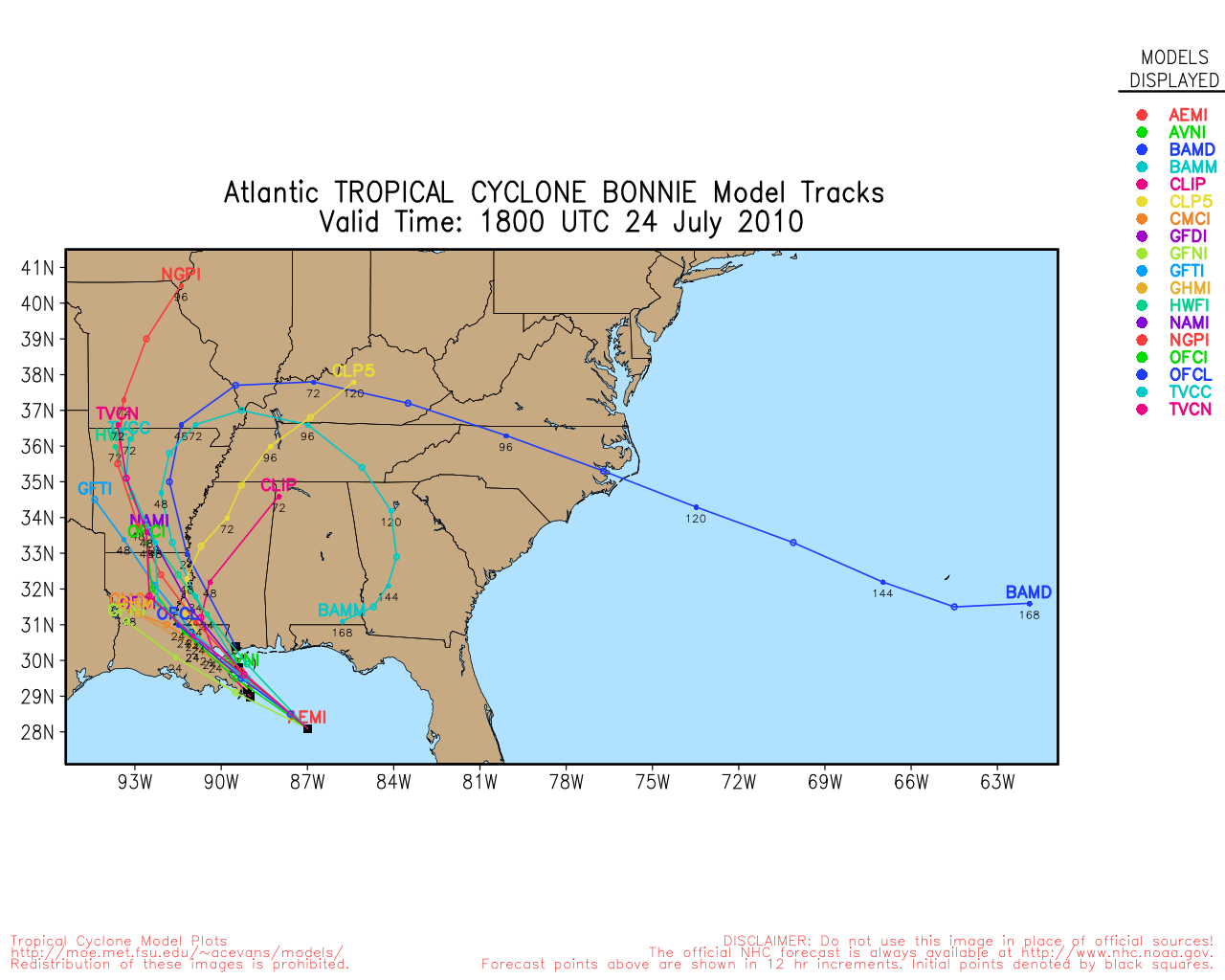
28.5N 87.6W
Windspeed: 30 MPH - Pressure: 1011mb
Movement: Wnw at 14 MPH
| Public Storm Advisory | BONNIE B C | Dvorak T-Numbers | TAFB ssd UW-CIMSS |
| Governmental Storm Discussion | BONNIE B C | ||
| Forecast Advisory | BONNIE B | ||
The letters B C D and so on stand for alternate information sites, in case one is inoperative during
a internet swamping for storm info you can try another. These advisories come from the National Hurricane center: Usually they
are updated at 5AM, 11AM, 5PM and 11PM eastern.
When land areas are under a hurricane watch, it is updated every 3 hours.
See 1 animated recording related to BONNIE --
Tropical Tidbits Info Page for BONNIE
- Weather Underground Wundermap
- NHC Interactive Map PlotWhen land areas are under a hurricane watch, it is updated every 3 hours.
Buoy Reports Near BONNIE - CIMSS Data for BONNIE - RAMMB Info and Satellites for BONNIE
Potential Storm Surge Flooding Map (Inundation) - NHC Track Map (See this animated)


 fa
fa
CIMSS Animated Satellite:

Weather Underground Animated Radar:


Coordinate History
| Adv# | Date | Lat | Long | Wind | Pres | Movement | Type | Name | Received | Forecaster |
| 1 | 07/22 11:00 AM | 21.9N | 75.0W | 35MPH | 1008mb | Wnw at 15 MPH | TD | TD#3 | 07/22 11:08 AM | Avila/roberts |
| 1A | 07/22 2:00 PM | 22.3N | 74.9W | 35MPH | 1008mb | Wnw at 15 MPH | TD | TD#3 | 07/22 1:45 PM | Avila/roberts |
| 2 | 07/22 5:00 PM | 22.7N | 75.4W | 35MPH | 1006mb | Nw at 14 MPH | TD | TD#3 | 07/22 4:37 PM | Avila/roberts |
| 2S | 07/22 6:15 PM | 22.9N | 75.4W | 40MPH | 1005mb | Nw at 14 MPH | TS | Bonnie | 07/22 6:38 PM | Kimberlain/beven |
| 2A | 07/22 8:00 PM | 23.1N | 75.9W | 40MPH | 1007mb | Nw at 14 MPH | TS | Bonnie | 07/22 7:52 PM | Beven |
| 3 | 07/22 11:00 PM | 23.4N | 76.5W | 40MPH | 1007mb | Nw at 14 MPH | TS | Bonnie | 07/22 10:47 PM | Beven |
| 3A | 07/23 2:00 AM | 23.8N | 77.5W | 40MPH | 1007mb | Nw at 16 MPH | TS | Bonnie | 07/23 2:08 AM | Brown/landsea |
| 4 | 07/23 5:00 AM | 24.1N | 78.6W | 40MPH | 1008mb | Wnw at 18 MPH | TS | Bonnie | 07/23 4:55 AM | Brown/landsea |
| 4A | 07/23 8:00 AM | 24.7N | 79.8W | 40MPH | 1008mb | Wnw at 19 MPH | TS | Bonnie | 07/23 7:43 AM | Avila/roberts |
| 5 | 07/23 11:00 AM | 25.4N | 80.3W | 40MPH | 1008mb | Wnw at 18 MPH | TS | Bonnie | 07/23 10:55 AM | Avila/roberts |
| 5A | 07/23 2:00 PM | 25.8N | 81.1W | 40MPH | 1008mb | Wnw at 18 MPH | TS | Bonnie | 07/23 1:49 PM | Avila/roberts |
| 6 | 07/23 5:00 PM | 26.2N | 81.9W | 35MPH | 1009mb | Wnw at 18 MPH | TD | BONNIE | 07/23 4:40 PM | Avila/roberts |
| 6A | 07/23 8:00 PM | 26.4N | 82.5W | 35MPH | 1009mb | Wnw at 17 MPH | TD | BONNIE | 07/23 7:48 PM | Beven |
| 7 | 07/23 11:00 PM | 26.4N | 83.4W | 35MPH | 1010mb | Wnw at 17 MPH | TD | BONNIE | 07/23 10:40 PM | Beven |
| 7A | 07/24 2:00 AM | 26.7N | 84.4W | 35MPH | 1013mb | Wnw at 17 MPH | TD | BONNIE | 07/24 1:49 AM | Brown/cangialosi |
| 8 | 07/24 5:00 AM | 27.0N | 85.1W | 35MPH | 1013mb | Wnw at 17 MPH | TD | BONNIE | 07/24 4:50 AM | Brown/cangialosi |
| 8A | 07/24 8:00 AM | 27.6N | 86.1W | 30MPH | 1013mb | Wnw at 18 MPH | TD | BONNIE | 07/24 7:37 AM | Avila/roberts |
| 9 | 07/24 11:00 AM | 28.0N | 86.7W | 30MPH | 1014mb | Wnw at 17 MPH | TD | BONNIE | 07/24 10:41 AM | Avila/roberts |
| 10 | 07/24 5:00 PM | 28.5N | 87.6W | 30MPH | 1011mb | Wnw at 14 MPH | TD | BONNIE | 07/24 4:41 PM | Avila/roberts |