CFHC Talkback For News Story #109:
Newest Talkback: 02:48 AM 09-22 EDT

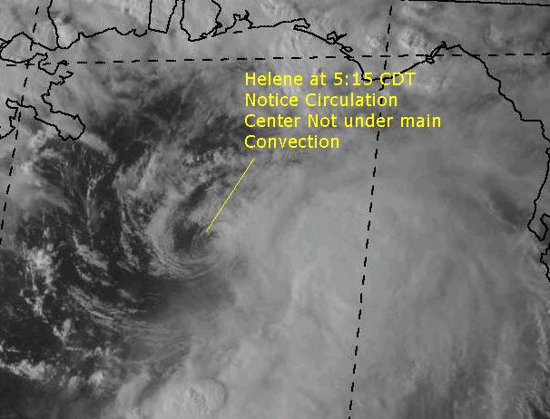
Helene Does Something Typical
06:41 PM EDT - 21 September 2000

By this, I mean the system's circulation center is away from the convection, which has been the story with a lot of storms this season. This is somewhat good news, as it means it cannot strengthen very easily now. It's slowed just a bit too, but this may cause it to weaken more than anything at this point. It still could strengthen, but I wouldn't bet on it.

Helene

Comments or Questions? Everyone is invited to use it. Use the comment button by the story Headline.

Joseph Johnston's Mobile Alabama Webcam (Hosted on CFHC)

NRL Monterey Marine Meteorology Division Forecast Track of Active Systems (Good Forecast Track Graphic and Satellite Photos)
Map with nearly all model projected tracks plotted for Helene. And TD#13 From Michael Bryson.
Crown Weather Services Tropical Update (Includes Map with multiple forecast model tracks)
Snonut's Hurricane Reports
Satellite images at: [Visible] (visible -- Daytime Only) [Infrared] (infrared), and [Water Vapor] (water vapor)
Loops: Visible Loop - Infrared Loop - Water Vapor Loop
NASA GHCC Interactive Satellite images at:
[NAtl visible] (visible -- Daytime Only) [NAtl infrared] (infrared), and [NAtl water vapor] (water vapor)--Nasa source.
Ocean Surface Winds Derived from the SeaWinds Scatterometer (Experimental)
Tormenta.net Español -- Gran información sobre huracanes aquí.

Some Forecast models: (NGM, AVN, MRF, ECMWF, ETA)
DoD weather models (NOGAPS, AVN, MRF)
AVN, ECMWF, GFDL, NOGAPS, UKMET

- [mac]


Show All Comments

Displaying Talkbacks #1 - #5 (of 5 total)

Don't see the slow down.... yet (#1)
Posted by:
Frank Location: Biloxi MS
Posted On 06:54PM 21-Sep-2000 with id (QURNQVSNQYUNRPR*)


Latest vis sat loops still indicate a steadly moving LLC... My estimated center is at 28.0 N and 87.19 W.. Thus has moved north from 27.6 to 28.0 in the past 100 minutes or so, which is approx 24 miles and indicates to me it continues on its predicted forward motion of about 13 mph..
System not very impressive right now without any CDO near the LLC...

Weird Storm (#2)
Posted by: L.T. (
http://www.ssd.noaa.gov/SAB/TROP/DATA/img/GMEXIR4.html) Location: Pensacola, FL
Posted On 07:00PM 21-Sep-2000 with id (QURNQVSNQYUNRPR*)


As Usually this year, every storm this year has had problems with shear, totally WEIRD. The Center may go over Pensacola but all the activity will be to the EAST!!!

Coming back!! (#3)
Posted by: L.T. (
http://www.ssd.noaa.gov/SAB/TROP/DATA/img/GMEXIR4.html) Location: Pensacola, FL
Posted On 10:02PM 21-Sep-2000 with id (RPUNQXXNRPPNUY*)


I see convection going back around the Center south of Pensacola!

Isaac Soon! (#4)
Posted by:
Ed Dunham Location: Melbourne, FL
Posted On 10:06PM 21-Sep-2000 with id (VSNQVRNRRVNUR*)


If you get a chance, take a look at the Metsat out of Dundee - Td13 already looks like a strong TS. A bit unusual for that far east. Outflow is quite impressive. This one seems destined for major league status in a few days.
Cheers,
ED

classes cancelled (#5)
Posted by: Frank Location: Tallahassee
Posted On 10:48PM 21-Sep-2000 with id (QRXNQXVNQRSNSW*)


ah, they did cancel classes before noon tomorrow.. great, i dont have any on friday. still, good for some folks. have fun, panhandle dwellers.
by the way, may be getting our isaac in just a few. take it easy, cfhc.


Show All Comments


Return to Central Florida Hurricane Center Main Page