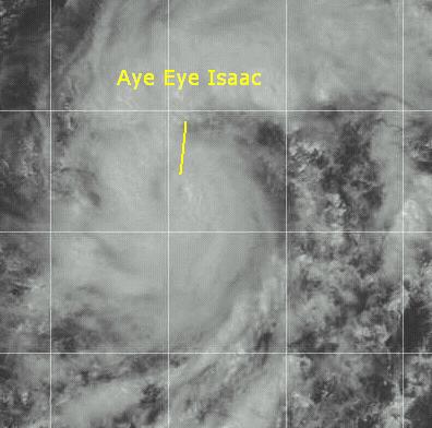
CFHC Talkback For News Story #112:
Newest Talkback: 02:25 AM 09-30 EDT

Aye Eye Isaac
01:26 PM EDT - 23 September 2000

Isaac has been upgraded to a hurricane. An eye is now apparant on satellite photos, which means that at the next advisory Isaac will be considered a hurricane. It's future still takes it west, with the shear less of a problem than originally thought. It's still a long way away from land and it still appears that it will not affect the Leeward islands. Never the less, it must be watched.

Hurricane Isaac in the East Atlantic

Comments or Questions? Everyone is invited to use it. Use the comment button by the story Headline.


NRL Monterey Marine Meteorology Division Forecast Track of Active Systems (Good Forecast Track Graphic and Satellite Photos)
Map with nearly all model projected tracks plotted for Isaac. From Michael Bryson.
Crown Weather Services Tropical Update (Includes Map with multiple forecast model tracks)
Snonut's Hurricane Reports
Satellite images at: [Visible] (visible -- Daytime Only) [Infrared] (infrared), and [Water Vapor] (water vapor)
Loops: Visible Loop - Infrared Loop - Water Vapor Loop
NASA GHCC Interactive Satellite images at:
[NAtl visible] (visible -- Daytime Only) [NAtl infrared] (infrared), and [NAtl water vapor] (water vapor)--Nasa source.
Ocean Surface Winds Derived from the SeaWinds Scatterometer (Experimental)
Tormenta.net Español -- Gran información sobre huracanes aquí.

Some Forecast models: (NGM, AVN, MRF, ECMWF, ETA)
DoD weather models (NOGAPS, AVN, MRF)
AVN, ECMWF, GFDL, NOGAPS, UKMET

- [mac]


Show All Comments | Show Next 5 Comments | Show Previous 7 Comments

Displaying Talkbacks #11 - #15 (of 26 total)

Helene Returns? (#11)
Posted by:
Richard Byett (http://www.stormwarn2000.com) Location: Gloucester, England, UK
Posted On 07:30PM 23-Sep-2000 with id (RQRNQSYNTPNYP*)


The Diamond Shoals Light, NC, bouy reports winds sustained at 46 kts / 53 mph! Pressure has fallen nearly 0.2 inches in 2 hours! The centre of what was Helene should pass this area as it head out to see. However given the figures and the imagery i am a little surprised NHC have not reclassified this system! A Tropical Storm Warning is in effect on my site for the area between Cape Lookout nd the NC / VA Border, but i expect the strongest winds to not reach either of these areas but to remain somewhere in between.
Does any one else have any information on this system?


Climatology limits Isaac? Not really... (#12)
Posted by: Buffo Location: Charleston, SC
Posted On 08:38PM 23-Sep-2000 with id (QRNSTNQYNRTY*)


I've seen it posted here (and elsewhere) that many believe Isaac will not threaten land because he formed so far east of 40W. (The claim being that no storms have ever struck the east coast after forming this late in the season and also so far east...) I would like to point out that Hurricane Hugo (1989) formed slightly *FURTHER* east than Isaac did, and still managed to make it all the way to the coast. Ok - I'll grant you that Hugo formed 10 days earlier in September than Isaac did, but is that terribly significant? I don't think so. We are still in the peak of the season; I can't understand this stubborn reliance on climatology when Isaac is so close to the percieved "limits" on course track.

issac (#13)
Posted by: scottsvb (
http://communities.msn.com/HURRICANEUPDATECENTER)
Posted On 09:22PM 23-Sep-2000 with id (VSNRSNQXYNQSU*)


Issac should continue to move wnw in the next 3 days then a turn nw by monday,,,,should have little to no affect on the US,....scottsvb

Difficult to Predict the Future! (#14)
Posted by:
Mitch McCauslin (http://home.cfl.rr.com/h2ocean/weather.html) Location: Cape Canaveral, FL
Posted On 10:21PM 23-Sep-2000 with id (RTNYUNRSQNST*)


Some people are saying it will recurve, others not so. It is just way too early to say either way! There are too many factors involved to predict whether or not Isaac will impact the Caribbean or U.S.; that is too far in the forecast period since the atmosphere is very dynamic. Yes there will be a trough that has a good chance too pull the system northward. However, don't forget that when systems become very powerful, it can modify the atmosphere around the system. There are just too many variables to say if there will be a U.S. impact or not, at this time.

isaac (#15)
Posted by:
gary Location: jacksonville
Posted On 10:52PM 23-Sep-2000 with id (QURNQVSNRQSNVV*)


when it comes to predicting anything this year , you might as well toss a coin in the air to figure where things are going....

issac (#16)
Posted by:
gary Location: jacksonville
Posted On 10:53PM 23-Sep-2000 with id (QURNQVSNRQSNVV*)


is now a cat 3, this should be fun to track.


Show All Comments | Show Next 5 Comments | Show Previous 7 Comments


Return to Central Florida Hurricane Center Main Page