CFHC Talkback For News Story #112:
Newest Talkback: 02:25 AM 09-30 EDT

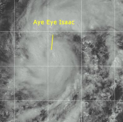
Aye Eye Isaac
01:26 PM EDT - 23 September 2000

Isaac has been upgraded to a hurricane. An eye is now apparant on satellite photos, which means that at the next advisory Isaac will be considered a hurricane. It's future still takes it west, with the shear less of a problem than originally thought. It's still a long way away from land and it still appears that it will not affect the Leeward islands. Never the less, it must be watched.

Hurricane Isaac in the East Atlantic

Comments or Questions? Everyone is invited to use it. Use the comment button by the story Headline.


NRL Monterey Marine Meteorology Division Forecast Track of Active Systems (Good Forecast Track Graphic and Satellite Photos)
Map with nearly all model projected tracks plotted for Isaac. From Michael Bryson.
Crown Weather Services Tropical Update (Includes Map with multiple forecast model tracks)
Snonut's Hurricane Reports
Satellite images at: [Visible] (visible -- Daytime Only) [Infrared] (infrared), and [Water Vapor] (water vapor)
Loops: Visible Loop - Infrared Loop - Water Vapor Loop
NASA GHCC Interactive Satellite images at:
[NAtl visible] (visible -- Daytime Only) [NAtl infrared] (infrared), and [NAtl water vapor] (water vapor)--Nasa source.
Ocean Surface Winds Derived from the SeaWinds Scatterometer (Experimental)
Tormenta.net Español -- Gran información sobre huracanes aquí.

Some Forecast models: (NGM, AVN, MRF, ECMWF, ETA)
DoD weather models (NOGAPS, AVN, MRF)
AVN, ECMWF, GFDL, NOGAPS, UKMET

- [mac]


Show All Comments | Show Next 5 Comments | Show Previous 7 Comments

Displaying Talkbacks #6 - #10 (of 26 total)

Isaac (#6)
Posted by: Joe Location: St.petersburg, Fl
Posted On 03:42PM 23-Sep-2000 with id (RQVNSNQXRNQUY*)


Isaac looks like its getting stronger,I think that will refelect in the 5pm advisory.I think they will have the winds at 80-85mph in the next update.Not to much sunlight left out there so we won't have the visible much longer. Joe

LOOK AT THESE T#'S!!!!!!!!!!!!!!!!!!!!!!!!!!!!!!!!!!!!!!!!!!!!!!!!!!!!!!!!!!!!!!!!!!!!!!! (#7)
Posted by:
Colleen Location: Lakeland, Florida
Posted On 04:20PM 23-Sep-2000 with id (QURNQVSNQYWNWS*)


Ok guys...look at this:

673

TPNT KGWC 231815

A. TROPICAL STORM ISAAC

B. 23/1733Z (120)

C. 14.6N/1

D. 34.1W/8

E. TWO/ME7

F. T4.5/4.5/D2.0 24HRS -23/1733Z-

G. IR/EIR/VIS/MSI


07/ PBO 15NM CLOUD-FILLED EYE. EYE HAS EMERGED FROM UNDER THE CDO. MG EYE IS EMBDD 38NM INTO LG RING. WHITE RING USED FOR EYE ADJUSTMENT, YIELDING A DT OF T5.0. FINAL T IS BASED ON PT. MET YIELDS T4.0. FINAL T CONSTRAINTS BROKEN.


MASSURA

Now, look at this:

CI MWS MSLP MSLP Saffir-Simpson
Number (Knots) (Atlantic) (NW Pacific) Category
1 25 K (Approximate)
1.5 25 K
2 30 K 1009 mb 1000 mb
2.5 35 K 1005 mb 997 mb
3 45 K 1000 mb 991 mb
3.5 55 K 994 mb 984 mb
4 65 K 987 mb 976 mb 1 (64-83 Kts)
4.5 77 K 979 mb 966 mb 1 (64-83 Kts); 2 (84-96 Kts)
5 90 K 970 mb 954 mb 2 (84-96 Kts); 3 (97-113 Kts)
5.5 102 K 960 mb 941 mb 3 (97-113 Kts)
6 115 K 948 mb 927 mb 4 (114-135 Kts)
6.5 127 K 935 mb 914 mb 4 (114-135 Kts)
7 140 K 921 mb 898 mb 5 (136+ Kts)
7.5 155 K 906 mb 879 mb 5 (136+ Kts)
8 170 K 890 mb 858 mb 5 (136+ Kts)

If I am reading this correctly, (and I may not be) they are saying that either 1) it's already at 4.5 classification with a likelihood of developing 2.0 in 24 hours, putting at a Cat 4 in 24 hours; or 2)it's at 4.0 right now, putting it at 6.0 in 24 hours at Cat 4 or 3) they think it's 5.0 now and that would put it at 7.0 in 24 hours which would a Cat 5.

Which is it? Either way, it's strong. Comments!!!!!

Isaac (#8)
Posted by: Joe Location: St.petersburg, Fl
Posted On 04:46PM 23-Sep-2000 with id (RQVNSNQXRNXY*)


I can't belive it

Hurricane Isaac (#9)
Posted by: Joe Location: St.petersburg, Fl
Posted On 04:55PM 23-Sep-2000 with id (RQVNSNQXRNXY*)


Winds 100mph. Pressure 980mb. This is going to a VERY LARGE STORM!!!!!!!!!!!!!!!!!!! jOE

Isaac, and Helene? (#10)
Posted by:
Richard Byett (http://www.stormwarn2000.com) Location: Gloucester, England, UK
Posted On 05:16PM 23-Sep-2000 with id (RQRNQSYNQXWNY*)


Well i posted earlier my views on Isaac, and he is indeed intensifying rapidly... he is going to be a major storm, lets just hope he does not hit land!
And i also posted earlier that the remnants of Helene looked to be reorganising as she neared the North Carolina coast. Well now NHC have issued a Tropical DisturbanceStatement confirming this, and when the low pressure centre is near to the coast, or just offshore, i think it will become a Tropical Storm once again. winds in the area are already near gale force!


Helene Returns? (#11)
Posted by:
Richard Byett (http://www.stormwarn2000.com) Location: Gloucester, England, UK
Posted On 07:30PM 23-Sep-2000 with id (RQRNQSYNTPNYP*)


The Diamond Shoals Light, NC, bouy reports winds sustained at 46 kts / 53 mph! Pressure has fallen nearly 0.2 inches in 2 hours! The centre of what was Helene should pass this area as it head out to see. However given the figures and the imagery i am a little surprised NHC have not reclassified this system! A Tropical Storm Warning is in effect on my site for the area between Cape Lookout nd the NC / VA Border, but i expect the strongest winds to not reach either of these areas but to remain somewhere in between.
Does any one else have any information on this system?


Show All Comments | Show Next 5 Comments | Show Previous 7 Comments


Return to Central Florida Hurricane Center Main Page